Frontiers of the Roman Empire

The Frontiers of the Roman Empire comprise significant remains of the Limes Romanus, a border defense or delimiting system of Ancient Rome.
It includes the Upper German-Raetian Limes, Hadrian’s Wall, and Antonine Wall, all built in the 2nd century CE in the northwestern part of the Empire. The Romans constructed military installations (forts, barriers, watchtowers, ditches) and related civilian settlements, linked by roads, to separate their citizens from the “barbarians”.
Community Perspective: The Roman Fort of Saalburg is the most visited part of the German component. The remains of Hadrian’s Wall can be admired on a hike (Ian), by the AD 122 bus, or by some selective exploration (James). A part of the (less well-preserved) Antonine Wall has been covered by Jay and Allan.


")
Map of Frontiers of the Roman Empire
Community Reviews
Puessergio

I visited the Ostkastell in Welzheim, Germany, and it turned out to be a pleasant surprise. The site is vast, and while I only explored a single fort, it was still an interesting experience. The walk through the area was enjoyable, with informative signposts and a few statues adding to the atmosphere. I wrapped up my visit with a run through the nearby woods, which made for a great combination of history and nature.
Bernard Joseph Esposo Guerrero

In driving around southern Germany, I managed to see two components of the Upper Germanic-Rhaetian Limes, dubbed as the longest monument in Europe at 550 kilometers long. The first one is Castra Vetoniana in Pfünz (Bavaria) and the other is the Double Fort in Osterburken (Baden-Wurttemburg). The weather forecast was not promising when we headed out for Ingolstadt. On the way, as predicted, it started to rain and we could only hope for that it would stop as we got nearer. Lying on top of a hill, Castra Vetoniana provides a commanding view over the village of Pfünz. Thanks to the rain, the parking lot was empty and so we had the whole site to ourselves. Luckily, after five minutes, the sky cleared up, and the structures were better revealed to us — indeed, a most pleasant introduction to the Limes!
As with most Roman cohort camps, Castra Vetoniana had defensive ditches and walls, as well as several buildings within. A section has been carefully reconstructed, allowing visitors to visually interpret the site. The recreated section comprises a tower, a gate, and the curtain wall that connects the two structures. We walked by the wall and then along the earthen trenches, reading a few information boards installed on the way. The patina-covered remains of the other three gates have been recovered and exposed for viewing too. It was also in Pfünz were I first saw a Römersäule (first photo), one of the nine historic stelas erected in the early 1900s, commemorating the initial interest made in mapping the Limes.
In figuring how to get to Maulbronn from Würzburg, my friend suggested a route that would pass through old towns. As I was not too keen on seeing more timber-framed houses, I took another look at the map and saw Osterburken instead, where I was drawn to more Roman ruins. Osterburken houses a unique double fort. It also has a reconstructed Roman watchtower and sections of its ditches on the side of a hill, and the views from our short walk from the parking lot toward it were delightful. Just like in Pfünz, we were the only visitors then.
The remains of the double fort in town, on the other hand, are probably the most authentic constructions dating back to Roman period. The outline of the Annex Fort is clearly visible as its foundations are still intact. The site of the annex fort was landscaped as a Limes Park, allowing locals and visitors to fully enjoy the archaeological site (with Children's playground) while preserving whatever remains of it. The adjacent main fort, however, lost almost all its structures as modern houses have long taken up the site where it once stood. Only the remains of the wall that it shared with the annex fort stands nowadays. There is a museum located a few meters away at a site of a former Roman bath.
It is free to visit both sites, sans the museum.
Read more from Bernard Joseph Esposo Guerrero here.
Solivagant

If you zoom in on the Map of Hadrian’s Wall on this Web site above you will note, on the far right, separated from the closely spaced locations along the Wall, another black dot titled “Roman Fort South Shields” – more commonly known as “Arbeia”. Whilst in no way suggesting that anyone should miss out the iconic central section of the Wall (situated in “wild country”) by giving this site (situated in a housing estate!!) preference, knowledge of its existence and merits might be prove to be of use to those with particular interest in “matters Romano-British” or whose travel logistics suit a visit to this most easterly element of the Hadrian’s Wall inscription.
Despite having lived within 40 miles of it for over 30 years we had never visited, but did so in March 2024 and were reasonably impressed. We had previously dismissed it as a “minor fort” which had received investment in 1986 in the form of a reconstructed Gateway looking similar (Photo), but in “pale comparison” to the massive reconstruction at Saalburg initiated by Kaiser Wilhelm II in 1897. Now, he had his own late 19th C German nationalistic and militaristic “reasons” for his project but, more recently, such reconstructions have been regarded as controversial. Apart from occasional examples where Hadrian's Wall has been filled in/stabilized for mainly conservation purposes, I think I am correct in stating that this is the only place to have been given a “full” reconstruction for “presentation” reasons. I had always been a bit “sniffy” about this, possibly “Disneyfied”, presentation of a Roman Fort and had given it a miss. A mistake I think.
So - why visit?
a. It is Free – unlike forts at nearby Segedunum (£6.95) and of course, Housesteads (£8.60)
b. It is easily reachable from Central Newcastle by Metro if you are staying in the city. Indeed an interesting “day tour” could be Metro to South Shields for Arbeia, cross the Tyne on the Ferry to North Shields/Tynemouth, Metro to Segedunum at Wallsend and back to the city. (Get a Metro day ticket - it includes the ferry!), This link provides a fuller guide to all the "Wall related" sights around Newcastle - including the Hancock Museum which has a "Wall Gallery"
c. If you are by-passing Newcastle to the east using the Tyne Tunnel e.g on your way north to the Northumbrian Coast or Edinburgh it is just a few miles off the direct route with no need to go into Newcastle itself.
d. It does, IMO, provide an interesting extra piece in the overall "Hadrian's wall jigsaw". A "thorough" visit will take around 1 to 1.5 hours, most of which will be spent in the museum and reconstructed buildings.
As indicated above, the Fort is situated rather unpromisingly in a housing estate near the centre of the industrial town of South Shields. Free parking nearby is easy. It is located on the first high bluff (“The Lawe”) on the south side of the Tyne estuary and its situation above the river can be seen best from a viewpoint a few hundred metres beyond the entrance. Although Hadrian’s Wall per se ended on the North side of the Tyne some 4 miles to the West at Wallsend, Arbeia was developed by the Romans to protect the major port which had been developed to supply the Wall and was then situated just below the fort (much of the present day land you will see below is infill compared with Roman days, created from ballast from “empty” ships arriving to take coal back to London). As such it is regarded as a part of “Hadrian’s Wall” even though it isn’t actually situated along it! At the entrance you will see a sign for “Hadrian’s Cycleway” where you can go “Coast to coast the Roman way” for 174 miles to the Glannaventa Bathhouse at Ravensglass (already reviewed on this Web site)!!
A visit starts with a small museum which sets out the history of the Fort and contains some interesting, if not “top class”, artifacts. Among the more significant are the Regina Tombstone with the only bilingual (Latin-Aramaic) inscription discovered in Britain (“To the spirits of the departed and Regina, freed woman and wife of Barates of Palmyra, a Catuvellaunian by race, thirty years old”). There are also seals of the Emperor Septimus Severus who, in AD208-10, came to Arbeia with an army of c40000 to personally manage the campaign to conquer Scotland. This was initially successful, but he died at York in 211, to be succeeded (initially jointly) by his sons Caracalla and Geta who had been campaaigning with him. They made peace with the Caledonians (Rome was never to advance beyond Hadrian's Wall again) and returned to Rome with their father's ashes - to be placed in the Castel Sant'Angelo. Many of the display cases are filled with items reflecting daily life as it was for the inhabitants. A nice “local” aspect is a fine collection of jet jewelry traded up from Whitby. There is also a 4th C Christian altar – unusual apparently for Roman Britain as the spread of Christianity within the Empire took place mainly in its South and East. There is a suggestion that the very name “Arbeia” comes from a late 3rd C garrisoning of the fort by soldiers from Mesopotamia (“Arabia”) – some of whom might well have been Christian. Generally an interesting “take out” from the visit is the extent of cultural exchange and mixing which occurred within the Roman world – reaching even these northern areas!!
Beyond the museum, the rectangular outline (c 150 x 100m) of the fort foundations are fully visible with its corner towers and the gates in each wall. Within, the foundations of many of fort’s buildings, consisting of quarters for the soldiers and granaries for storage, packed closely together, are also clear. But as a “working fort”, there are no particularly noteworthy remains in situ - mosaics, statues, carved friezes etc. A couple of Roman pillars have been discovered and erected and there are the usual Roman latrines! It appears that the fort was reorganized and extended from a near square at the time of the Severus campaign to develop its role as a supply base with a reduction in soldiers’ quarters and the building of extra granaries (with design features to aid drying etc). There are also later remains of kilns for tile making. Around half is unexcavated and under grass, but all the houses which once partially covered it, have been demolished. Excavations commenced as early as the 1870s and the the preservation of the site by local initiative was one of the earliest examples of this happening in UK.
Which takes us to the reconstructed buildings. As mentioned above, I was aware of the West Gate from 1988 but did NOT know that it had been followed in the early “2000s” by construction of a Barrack Block and (part of) a “Commanding Officer’s House”. This quote describes each -
“West Gate: Climb the reconstructed West Gate and get a feel for how soldiers would have entered and exited the fort
Barracks Block: Explore a reconstructed barracks block to understand the living conditions of Roman soldiers stationed there
Commanding Officer's House: See what life was like for the high-ranking officer with a reconstruction of their much more luxurious home compared to the barracks”
All have been built on the original foundations but without using any original materials. It is said that appropriate building techniques were used and that the reconstructions contributed knowledge via “Experimental Archaeology”. There was opposition to the original Gate rebuild but I haven’t found evidence of there being any for the subsequent Barracks/Officer’s House – possibly surprising since they significantly post-dated the UNESCO inscription. The opening of the West gate came just after the original Hadrian’s Wall inscription in 1987 but must have been well under way at the time of the AB Evaluation - however, neither that nor the Nomination file even mention it!!! Either ICOMOS didn’t care ….or didn’t know!
This article gives a general impression of the rebuilds. This describes the Barracks and this concentrates on the Commanding Officers House. Each of us will make up their own mind about the value of and justification for the “reconstructions”. In my view they seem
a. Not to have damaged or compromised the underlying authentic remains and thus do no “physical harm”
b. To have been done with expert knowledge and care, albeit that some details might be subject to academic debate as to their authenticity
c. To add value to visitors by providing background and context to what would otherwise just be a jumble of low stones and thus contribute to a possibly undervalued purpose of presenting such remains – viz “education”.
In the case of the Commanding Officer's house I can wonder whether the reconstruction has perhaps gone overboard on the decorative plaster work and room furnishings etc for what would have primarily been a “working fort” at the edge of “Roman civilization”. But it was still worth seeing, even if I suspect that the main beneficiaries are the school parties "playing" at being Romans!
James Bowyer

Much has been said about the highlights of Hadrian’s Wall, particularly the area around Housesteads and Vindolanda, and these are indeed best-preserved sections so should be top of the list for anybody who has not visited before. Rather than add to this, I thought I would offer some insight into the more obscure sites for those in the area for longer. Starting at the easternmost edge, the fort of Arbeia guarded the mouth of the River Tyne and features some original foundations as well as a reconstructed gatehouse and barracks. Arbeia is close to South Shields metro station, which has regular connections into the centre of Newcastle via Bede station, from which it is a short walk to the tentative WHS of Jarrow Monastery. Across the Tyne to the north, the fort of Segedunum marks the start of the cross-country Hadrian’s Wall long distance walking path but is less impressive as only the shape of the foundations survives with few original remains but the signage at the nearby Wallsend metro station is in both English and Latin, which offers some amusement. Depending on who you ask, the area is perhaps more famous for Wallsend Boys Club, the football (soccer) club that produced such great players as Alan Shearer. Further west, but still within the urban sprawl of Newcastle, a small shrine (see attached picture), section of vallum crossing, and parts of the wall can all be seen in the area of Benwell. Whilst not the most impressive remains, it is quite surreal to see fragments of a nearly 2000-year-old border fortification now surrounded by the semi-detached houses of English suburbia.
The farmland of southern Northumberland and Cumbria is dotted with occasional stetches of wall in various states of repair as well as the vallum earthworks, many free to access in the open countryside. The Hadrian's Wall Path provides a public right of way along the whole length of the wall, some 135 kilometres from coast to coast. Most of the wall was slowly dismantled following the Roman withdrawal from Britain, with stones going to build medieval farmhouses, dry stone walls and churches. The largest scale destruction was carried out in the 18th Century to build General Wade’s military road to move troops up to Scotland to crush the Jacobite uprisings. It was a clerk and laywer from Newcastle, John Clayton, who began the first efforts to save what was left of the wall in the 19th Century, buying land from farmers to stop continuing extraction of the Roman stone and began various archaeological excavations. Today, the various major forts that Clayton preserved are well-signposted from the roads and many are also served by the AD122 bus as others have mentioned. Further west, the area between the villages of Lanercost and Gisland, the latter reachable by the 185 Tynedale Links bus, near Birdoswald fort features the tallest and longest continuous surviving parts of the wall, including the impressive remains of a bridge abutment at Willowford Farm. Lanercost itself is home to a large 12th Century abbey built from the stones of the nearby wall. To the north at Hare Hill is the westernmost remains of the wall still visible above ground. Some way south of the path of the wall, and close to Brampton railway station, the written rock of Gelt features Roman engravings in the location where stone for the wall was quarried but the writing is difficult to see amongst the vegetation from the riverside path and is quite high above head height so more of academic interest than worth seeing in person.
There are various components inscribed westwards through Carlisle, reaching the coast at Bowness-on-Solway. However, there is very little to be seen above ground from Hare Hill onwards so these are best skipped unless keen to walk the whole length of the wall that was. The southernmost location for Hadrian’s Wall is further west still with the remains of a bath house at Ravenglass, again conveniently close to a railway station and offering the opportunity for a double tick being inside the core zone of the English Lake District. I have yet to see the German limes and have had only one encounter with the Antonine Wall, visiting Rough Castle just outside of Falkirk some years ago and recall the earthworks being quite imposing, larger than most of the vallum that can be seen along Hadrian’s Wall. The 439 individual components of this site seem excessive, with many of those inscribed having no visible remains and being of interest only to archaeologists. Perhaps a more selective approach would have been preferable, if only to make maps of WHS locations less crowded. That minor complaint aside, those parts of Hadrian’s Wall that do survive are quite magnificent and, at nearly two millennia old, they are a remarkable testament to the power and scale of the Roman Empire that it could build and maintain fortifications in such difficult and distant terrain from the windswept moorland of northern England and Scotland to the deep dark forests of Germania and Dacia and the (not-yet-inscribed) deserts of Africa and Arabia.
Jakob Frenzel

March 2018 - After our stay at the Lake District we continued our Journey to Newcastle.
We looked for the nicest route which was always along the Hadranwall. Most parts however were not very spectecular, but some other parts whereas were quite interesting. We made a few foto stops, but at the end the whole drive to Newcastle was very fast.
The German Limes we haven't really visited yet.
Allan & Lucia

Of all the WHS on the list, I’ve been to Hadrian’s Wall the most. Growing up, it was the closest, and as such, I’ve visited most of the best preserved sections: Birdoswald, Walltown, Halsteads, Vindolanda, Chesters. How best to officially ‘mark off’ such a familiar site?
We chose to walk a 10 mile section of the wall, from the Walltown Quarry section all the way to Halsteads fort, on a blustery but clear December afternoon, which really added to the atmosphere. This section represents the wall at its best preserved and most dramatic, and truly gives an impression of what the Roman soldiers posted along the wall must have felt, being on the fringes of the empire. The walk along the top of the ridge was very pleasant, though can be a little taxing in places. Halsteads is personally my favourite of the surviving fort remains, though if you’re not a member of English Heritage, it will cost you to get in. I would wholeheartedly recommend it. The AD 122 bus is very helpful for getting about, and let us get back to our parked car with little issue.
Earlier that year, we also visited the Antonine Wall in Scotland. Stretching from the Clyde to the Forth, the Antonine Wall is the northerly sibling to the more famous Hadrian’s Wall. Occupied for far less time, the Romans constructed a more temporary structure, and as such, much of it was constructed out of dirt rather than stone. Compounding the problem, the central belt of Scotland is far more populated than Cumbria and Northumberland, and thus any stonework that did exist was mostly repurposed into building material. The two best preserved sections, Bar Hill and Rough Castle, are easily visited by car from either Glasgow or Edinburgh. They were perhaps a little more difficult to appreciate as remains, but none the less they both made for a very pleasant and enjoyable day trip.
Frederik Dawson

In August 2006 I visited the Roman fort of Saalburg, a part of Upper German-Raetian, and at that time I wrote a review that the German section of this World Heritage Site was not well known compared to its counterpart in England because the German Roman frontiers were hard to see as it was almost entirely built by wood and right now most of them are just many small traces on the grassland or the few stones in the forest. It was really hard for normal people to appreciate this site. The only place you can get some imagination of Roman fortress is Saalburg, just north of Frankfurt, which has a fully reconstructed fort and good museum. Saalburg Fort has been mentioned in ICOMOS document as the only new reconstruction part of German-Raetian that ICOMOS accepted as a WHS, so it tells you something about the quality of this place. At that time, the best way to see Saalburg was to take a train to to Saalburg via Bad Homburg and followed the hiking route to "Romerkasteel Saalburg" for about 2 km. I remembered that I walked through lovely forest and saw some traces of the Raetian which was quite fascinating to see some ruins left in the German forest, after a good long walk in nature it was quite shocking to discover that Saalburg fort is just next to a very busy German Highway.
A decade later in December 2016, I have visited the most famous part of this UNESCO site, the Hadrian’s Wall in Northern England and the lesser-known Antoine Wall in Scotland, it was a totally different experience with the German one. Hadrian’s Wall was located on the beautiful grassland hills with the long line of stone wall that seem to be endless. Something that really remarkable to see and easy to appreciate. I drove from New Castle to Carlisle and saw many well-preserved sections of this great heritage site. I did many brief stops to hike along the wall and to admire the breathtaking surrounding of Northumberland and Cambrian landscapes. One of my favorite parts is the Cawfields section near the town of Haltwhistle. Not only has the Hadrian’s Wall reached one of the highest hills, the view of long line of stone wall was almost similar to the Great Wall of China, the nearby Cawfields Quarry where the Roman cut the stone to make the wall were also interesting to see. While the Hadrian’s Wall offered a remarkable experience, the Antoine Wall brought me back the memory of the German part. The Scottish section actually was quite similar to the sites in Germany. There was almost nothing to see except some earth mounds. I would rather say the German part is actually maybe better at least there were some stone foundation left, but for Scotland, there was really nothing. Fortunately, I combined my trip with the Falkirk Wheel and the contemporary giant art of the Kelpies which made my trip more enjoyable.
I believe that this World Heritage Site is going to expand to include other Roman Frontier especially in Eastern Europe and the one in Netherlands. While I have no objection to add more sites as their historical values are quite obvious, the question of is there anything left to see is my main concern. I really enjoyed Hadrian’s Wall because it is something that really exist, something I can see, touch even climb on it, and actually one of the best World Heritage Site of England. But in Germany and Scotland, sometimes I need to use a lot of imagination to appreciate the empty sites. I hope this great site in the future will not become the collections of obscure pits or holes or anything that archaeologists and historians can link to the Roman.
Clyde

I visited the Hadrian's wall in June 2016. I'm glad I had visited Germany's Limes first as my expectations were low and moreover I could appreciate the OUV of this transnational site. I was lucky to visit on the only day without rain for days on end, so much so that I spent a whole day here instead of a couple of hours before heading to Durham. As I drove westwards from Newcastle I made a couple of stops along the road to Carlisle. Most of the car parks are not free, however the pay and display ticket is valid for all the car parks. I visited the remains at Carrowburgh: Temple of Mithras and walked quite a stretch along the hadrian's wall path there to see the parts where the wall is still covered by grass and soil and a great grazing spot for sheep. After a long walk, I went back to the car park and drove to the Roman auxiliary fort of Vindolanda. Although this is the largest set of ruins and also the oldest (it predates Hadrian's wall!), I felt it was geared too much at attracting childrens' attention and at times it felt like a school outing hotspot. Next I drove a couple of kilometres past Housesteads Roman Fort and parked next to a visible part of Hadrian's wall with very big stones, a few metres from the main road. This helped me appreciate the seemingly neverending length of the wall across the rolling hills of Northumberland. The sight of the remains of Housesteads was a welcome change and it surely must have been an imposing fort as there are lovely views from there. I think that visiting Housesteads Roman Fort is a must to get a very good overview of several elements of this inscription. There's a very small museum next to the fort with some remains and also the UNESCO plaque in shocking pink. I also visited the Roman sites in Corbridge before heading towards Durham. All in all, I really enjoyed my visit and look forward to visit the Antonine wall in the near future.
Jay T

The Antonine Wall in Scotland, constructed almost 1900 years ago, was the northernmost Roman barrier in Europe, and became the newest extension to the Frontiers of the Roman Empire World Heritage Site in 2008. I visited one section of the wall at Rough Castle Fort on a sunny afternoon in September 2015. Rough Castle is very close to the Falkirk Wheel, so I parked by the wheel and continued on the path above the canal to the site of the fort on the Antonine Wall. Unfortunately, because the wall was turf-covered and the wood structures are no longer extant, not much is left to see. The most striking feature is a defensive ditch with a turf-covered rampart. Beyond the rampart are foundations for former structures, such as a barracks and a bath house, and most have helpful placards to provide context. I found the section of the Antonine Wall at Rough Castle Fort to be peaceful and interesting to explore, and I look forward to some day seeing other components of this World Heritage Site in England and Germany.
Logistics: The Antonine Wall stretches across Scotland between the Firths of Forth and Clyde, and is accessible by car and foot; the sensational Falkirk Wheel made a good base for parking and hiking to Rough Castle Fort.
Michael Turtle

There are lots of ways to see this WHS - in two countries. I have been to the UK's Hadrian's Wall site, but for the German bit, I focused on Saalburg Roman Fortress near Bad Homburg. It is the only Roman fortress in the world to be rebuilt and is imposing on a hill with large external walls guarding the buildings inside.
If a reconstructed Roman fort is not your thing but you’re in the area near Saalburg, another option is to go exploring yourself. In the forests nearby are relatively untouched Roman ruins and visitors are free to hike along the trails and discover things for themselves.
In fact, it’s the same along much of the original boundary wall that stretches across the Germany. Although there are official sites that have been protected or restored, there’s still a lot which is just out in the open. Because the original route of The Limes covers so much of the country, it’s easy to come across a part of it on your travels and see what there is to visit in the area.
Read more from Michael Turtle here.
Tom Livesey
I visited Hadrian's Wall in October 2015 whilst in the area for a family reunion. We walked a circular route of about 10km, starting in the Northumbrian hamlet of 'Once Brewed', walking along the wall and taking in two of the ruined Roman forts - Housesteads and Vindolanda (although without paying to enter them).
There is quite a view of the lakes below from the ridgeline between Once Brewed and Housesteads, so I can recommend it as a section worth visiting. Having said that, there was little to see but fog when we went.
Hopefully somebody can visit and review the Antonine Wall for us, since nobody seems to have covered this recent addition yet.
Read more from Tom Livesey here.
Clyde

I visited the German Limes and Roman Fort of Saalburg in Bad Homburg in October 2013. The Limes are the only original stone remains still in place today in Germany. The rest was mainly made of wood and therefore only reconstructions can be seen. Having said this, the Roman Fort in Saalburg really gives you a concrete idea of the importance attached to control the borders of the Roman Empire. There are several informative posters in German and English as well as several artefacts excavated from this site. The price is reasonable and parking is free. Hopefully I'll have the opportunity to visit Hadrian's Wall in the near future but I'm glad I visited the German sites first.
Ingemar Eriksson
I visited the Roman Museum in Aalen which is east of Stuttgart along B29 road. It is a museum built at the site of a roman cavalry fort along the Limes. Actual ruins of the fort outside. Several other places along the Limes i identified and preserved or rebuilt. There is also a Trail along at least parts of the Limes in Germany, look for "Limeswanderweg" in your search programme.
As Limes mainly was built of wood, it is not likely much could survive up to now. They have rebuilt tower for guardians some 10 km east of Aalen and in the same areas are some other sites to look at.
Ian Cade

I had previously resisted the temptation to tick off this site by visiting the remnants of Hadrian’s Wall in suburban Tyneside, so to do the site some justice I decided to walk a craggy 20km stretch of the wall between Once Brewed and Chollerford on an overcast Saturday in June.
This was an exceptionally rewarding walk taking in the wall at its scenic best. The first section from Once Brewed until Housesteads was particularly impressive, especially the dip down to Sycamore Gap. It was a fairly strenuous trek, but the wall was continuously visible on this stretch and viewing it meandering up and down the hills was really rewarding. It was surprising just how much archaeology there is at this site. We had a look at ruins at Houseteads and Chesters, both of which were large sets of ruins and would be worthy of inscription by themselves, however there were turrets, milecastles and remains of temples popping up consistently along the 20km we walked. It must be a real delight for archaeologist to know just how much information they can gain from these sites.
Like many others here we used the AD 122 bus which was a very useful way of getting to the start of our walk, and I imagine would be exceptionally useful if wanting explore the sites along the wall without your own transport. I runs from Newcastle which I think is one of England’s most interesting cities so gives you a chance to mix and urban stay with a bit of rural sight-seeing.
I am pretty sure I will return to Hadrian’s wall at some stage in the future, and I would also be keen to visit the sites in Scotland and Germany to see the other incarnations of the roman frontier. The walk along the middle section of the wall was a really great way to get some exercise and also visit one of Britain’s best historic sights.
[Site 7: Experience 8]
John booth

Having now visited the boundaries of the Roman Empire in Britain and Germany I must say that the British wall is much more visible, and accessible thanks to the AD122 bus. Saalburg is indeed an interesting reconstructed fort in a pleasant forest location on a hilltop. I reached it by bus from Bad Homburg. From the fort I walked downhill through the forest passing several marked watchtower foundations along the way, to reach Saalburg station.
Near Neuwied on the Rhine I found some excavations of Roman Baths in Niederbieber, and a reconstructed watchtower on a hilltop in Oberbieber. Both were reached by bus # 101 from Neuwied.
In Miltenberg on the Main river there is an interesting museum displaying a number of Roman artifacts found along the Limes in that area.
In Aschaffenburg I visited the Pompejanum, a reconstructed Roman villa.
Near Konigstein in the Taunus I visited Kleine Feldberg, an excavated fort and bathhouse up a track from the Rote Kreutz bus stop at Glasshutten.
There are many other locations worth investigating listed on the Limesstrasse website, but they recommend travelling by bicycle if you want to travel the whole distance.
Jay Wills
As a proud Northumbrian I have a keen interest in what happens to Hadrian's Wall. This summer I have been looking at it in depth for part of my University work. Visiting Vindolanda for the first time in about ten years, as well as Housesteads for the first time ever, has been very enjoyable - despite the dismal weather during my visit to the former. For anyone who does not have the benefit of a car to get around, using the AD122 bus is a must.
Also, this summer I took a trip to Germany to visit Saalburg for myself. It is genuinely a fascinating place. In terms of value for money it was excellent. The bus fare from Bad Homburg station, as well as the entry fee, were both very reasonable. For any aficianados of Roman history, visiting Hadrian's Wall and Saalburg are a must!
David Berlanda
Italy / Czech Republic - 01-May-05 -

In our trip to Germany we have visited the Roman fort of Saalburg, part of the 220 kilometres Limes barrier Raeatian section, one of the walls that have been marking the boundaries of the Roman empire for some centuries. The original fort (90 AD) covered an area of about 0,70 hectares and had a rectangular plan with corner towers. In 135 AD was built a larger fort, of 3,2 hectares (221 by 147 metres), over the earlier one, with four gates, a stone and timber defence wall with rampart walk and a double ditch. The remains of many internal buildings have been excavated and entirely reconstructed in stone and timber under the emperor William II. There are the granary, the commander’s quarters, the barrack blocks for the common soldiers and the headquarters buildings with the monumental assembly room the colonnaded courtyard, the rooms, the offices and the armouries. Interesting are the reconstructions of a barrack room, home to a squad of eight soldiers who lived in close quarters, of the richly decorated officer’s dining room, of the regimental shrine, the spiritual and religious centre of the fort, of the ovens and of the “restaurant”. Between the remains of the civilian settlement just outside the fort there is a bath house, a guest house, the cellars and the wells of the private houses and the reconstructions of the Jupiter column and of the Temple of Mithras. Near the fort there is a reconstruction of the limes at an ancient border crossing and a long elevation of the soil where it passed.
I quite liked the fort because it’s an impressive example of a Roman border fort, even if we have visited the remains outside the fort quite in a hurry, because they are in a wood and it was raining. The fort is worth of visit if you are in Hesse and I think that the Limes absolutely justifies the inscription, but in my opinion with the Limes in Germany and the Hadrian’s Wall in UK can be inscribed the whole boundaries of the Roman Empire in many countries. The state of conservation of the building is sometimes very good (the reconstructions), and sometimes they are ruined, but I think that the reconstruction of the fort, even if it has a historical value because it is of the 19th century, was a completely wrong decision that compromises completely its authenticity and the only authentic buildings are those ruined outside the fort. It is easy to reach Saalburg: you have to exit from the highway A5 going from Darmstadt to Bad Hersfeld at Bad Homburg and then take the road B456; you have to pay to visit the fort, but not the remains around it (if you want to see them well, walk on the Saalburg Circuit Road, 2,4 kilometres long, that brings you to the Limes and to the other remains).
Photo: Saalburg - Fort walls
Els Slots

I toured the eastern part of Hadrian's Wall by bus from Newcastle, in the appropriately named AD122. This public bus stops at all things worth seeing along the way, so you can hop off and catch a later bus after you've visited the site. A good service I think.
My first stop was at Housesteads, the remains of a fort just at the wall. Because it was built on a hill, there are fine views over the countryside here.
Vindolanda is a bigger complex, somewhat inland from the wall. This Roman site is actually older than Hadrian's wall itself. Archeological excavations are still underway here, and some reconstruction has been done so it is easier to imagine what it looked like in ancient times. It's also the finding place of the historically quite spectacular Roman writing tablets, that tell about daily life in this area in Roman times.
Klaus Freisinger
After a long period of aggressive expansion, the time had to come for one Roman emperor to put a stop to it and say out loud that Rome was not actually destined to rule the entire world and that the Empire had to have stable borders. This man was Hadrian, and to secure the borders of the Province of Britannia, he had this magnificent wall built between the coasts of the North and Irish Seas to separate, as the famous statement goes, "the Romans from the Barbarians". (Later, though, the borders were pushed even further north, when the Romans built the Antonine Wall in today's Glasgow-Edinburgh area and the south of Scotland was also part of the Empire). Breathtaking views make a hike along the wall a wonderful experience (and you can see the oaktree featured in "Robin Hood, Prince of Thieves"...) that nourishes your body as well as your mind. Roman history and their way of thinking rarely can be appreciated so closely. It is surprisingly easy to visit the Wall, at least coming (as I did) from Newcastle, where the AD122 bus waits for you. The sites of Vindolanda, Housesteads, and Chesters are especially interesting and give a great overview of the area's history and archaeology, especially about the Romans' daily life. Many letters from the soldiers posted here have survived, and some are quite funny, such as the auxiliary troops from Spain and Syria complaining about the miserable weather. I went there on a glorious (but probably rare) summer day, but I think the area is interesting even in winter. One of the best sights I have seen in all Britain.
On a separate trip to Germany, I visited the Saalburg, a reconstructed border castle near Bad Homburg. It was actually built around 1900 on the orders of Kaiser Wilhelm, and provides interesting insights into Roman life on the frontier. Some original features are still preserved, both inside and outside the castle, as well as some actual remains of the Limes itself, about a 10-minute walk away from the castle through the forest (complete with "You are now leaving the Roman Empire" signs).
On yet another trip, I went to see the Antonine Wall. From Falkirk station (on the line between Glasgow and Edinburgh), I took a taxi to the site of Rough Castle and took a walk around - there is really not much left to see, basically only trenches and other changes in the landscape, no built structures. There are some helpful signs, but you need a bit of imagination here.
Community Rating
- : Eric Lurio BobSmithseestheworld Chrysalis_kat Damientournay
- : Anne JR's HERITAGE SITES
- : Klaus Freisinger Frederik Dawson Sachin Argo SirLoydd WalGra Christoph KoenigMarke Rodinia Luki501 Aslak Fozzak Viaje al Patrimonio Rafał Kałczuga Andrew_Kerr Sturuss
- : Ian Cade Martina Rúčková Wojciech Fedoruk Xiquinho Silva Jay T Allan & Lucia Daniel Gabi Antonio J. Joebobs Jarrod_Byham Richard Stone Forest80 James Bowyer Digits Eatexplore57 Zach Ljowers CyBeRr Laurine Ming_9734 Manuelfunk RyanJ WestcountryWanderer KngAlaric Bropyk
- : Solivagant Gary Arndt Khuft Peter Lööv Craig Harder Bernard Joseph Esposo Guerrero Randi Thomsen Svein Elias Alexander Parsons Ralf Regele Shandos Cleaver Can SARICA Christravelblog MaxHeAnouBen VLabhard MoPython Hanming Bill Maurmann Dutchnick John Rvieira Sbshipway Rich Forrest Emily Cullen Ssong.x Awestix CeeCeeSR Puessergio BMuramatsu Gautamiyer23
- : Jakob Frenzel Daniel C-Hazard Ivan Rucek Hubert Clyde Jean Lecaillon George Gdanski Lucio Gorla HaraldOest AT8 Aspasia Kbtwhs Shoaibmnagi Adrian Turtschi Ralf Rotheimer GerhardM Federico P.
- : Els Slots David Berlanda Philipp Peterer Jan Zimmermann Caspar Dechmann Mike Nolan B. Stanislaw Warwas Lukasz Palczewski Ilya Burlak Alexander Lehmann Anna Olshäll Mahuhe Philipp Leu Max Trekkie900 ReallyDeepThoughts
- : Nan Tony0001 Dwight Zehuan Xiao Tarquinio_Superbo CugelVance Allnamesused
- : João Aender Zoë Sheng Dorejd Aidan Coohill Sebasfhb Simonh Yevhen Ivanovych GZ
- : Mstrebl1990
Site Info
- Full Name
- Frontiers of the Roman Empire
- Unesco ID
- 430
- Country
- Germany United Kingdom
- Inscribed
- 1987
- Type
- Cultural
- Criteria
-
2 3 4
- Categories
- Archaeological site - Ancient Rome Structure - Military and Fortifications
- Link
- By ID
Site History
2008 Extended
To include the Antonine Wall
2005 Extended
To include two sections of the Limes in Germany
1987 Inscribed
Site Links
Unesco Website
Official Website
Related
In the News
Locations
The site has 438 locations
Connections
The site has 56 connections
Art and Architecture
Constructions
Ecology
Geography
History
Human Activity
Individual People
Literature and Film
Religion and Belief
Science and Technology
Timeline
Trivia
Visiting conditions
WHS Hotspots
WHS Names
WHS on Other Lists
World Heritage Process
Visitors
556 Community Members have visited.
The Plaque
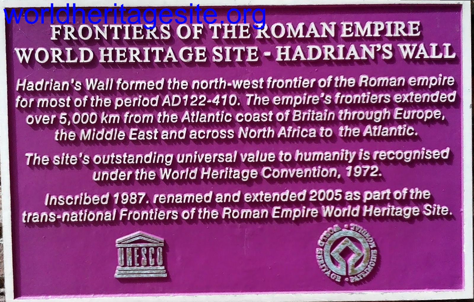 (photo by Solivagant)
 (photo by Squiffy)
 (external source)
 (external source)