Al-Faw

The Cultural Landscape of Al-Faw comprises the remains of a pre-Islamic caravan station, which was important for the frankincense trade. It lies at the fringe of the Empty Quarter.
Community Perspective: Zoë has described her non-visit, one of Tamas's party crawled in but found nothing of note, and Philipp has confirmed that in 2024 the site still is fully closed to tourists and nothing of its OUV can be seen from behind the fence. For future reference on how to get there once it opens (2030?), there's an airport relatively nearby at Wadi Al-Dawasir with daily flights to Riyadh and Jeddah.
Badain Jaran Desert

Badain Jaran Desert is located in the Alashan Plateau in the hyper-arid and temperate desert region of northwestern China and contains a concentrated distribution of mega-dunes with a relative height of more than 200 metres, and the inter-dunal lake basins.
It is an ideal place to study the ongoing evolutionary processes of desert geomorphology in the temperate extreme arid desert region.
Community Perspective: Zoë went "years ago" and suggests seeing the various lakes and the singing dunes.
Beijing Central Axis

Beijing Central Axis: A Building Ensemble Exhibiting the Ideal Order of the Chinese Capital showcases urban planning along Confucian ideas.
The design is based on a symmetrical north-south axis with a ‘centre’. The Axis is 7.8 kilometres long and stretches from the Bell and Drum Towers to the Yongdingmen Gate, with 15 major landmarks along the way such as the Forbidden City, the Temple of Heaven and Tian'anmen Square.
Community Perspective: Reviewers wonder why this needed to be a separate inscription, as parts have been inscribed as other WHS also. Kyle has highlighted the additional parts.
Brâncusi Monumental Ensemble of Târgu Jiu

The Brâncusi Monumental Ensemble of Târgu Jiu is the master work of sculptor Constantin Brancusi.
It was created in 1937 in memory of the heroes who fell during the First World War. The ensemble comprises three sculptures, The Table of Silence, The Gate of the Kiss and the Endless Column, and the visual axis that connects them.
Community Perspective: A divisive site, Els applauded the introduction of outdoor art to the List. Others had a harder time getting to grips with it, which was worsened by its earlier marketing as a Site of Memory.
Cultural Landscape of Kenozero Lake

The Cultural Landscape of Kenozero Lake is renowned for its collection of historic wooden buildings.
They comprise both domestic and religious buildings (some with distinct interior paintings), made by Slavic settlers from the 12th century onwards. Adding to the sacred landscape are wooden crosses, cemeteries and sacred groves. They are located in the scenic landscape of Lake Kenozero.
Community Perspective: Martina found a lovely area geared to ecotourism.
Dacian Limes

The Dacian limes is the longest land Roman border sector of Europe, stretching over more than 1000 km.
It comprises hundreds of Roman sites all across Romania. Various geographical conditions had to be overcome to create man-made barriers and fortifications.
Community Perspective: Nan checked a few remnants here and there and finally settled on Alba Iulia, while Els visited Porolissum which is the main site in the Northwest and probably the best-preserved overall.
Gedi

The Historic Town and Archaeological Site of Gedi comprises the remains of a Swahili coastal settlement and maritime trade center that flourished between the 12th and 15th centuries.
The town, abandoned in the 17th century, had inner and outer city walls. Residential areas show segmentation between the social classes. Also, the distinct street layout, pillar tombs, the palace, and two Great Mosques have been preserved. Most buildings were made of coral stone from the Indian Ocean. The town was built 6km inland from the sea, possibly for defensive reasons.
Community Perspective: Go and see these atmospheric, overgrown ruins.
Hegmataneh

Hegmataneh or Ecbatana comprises the ruins of a city of the civilization of the Medes.
Later it became the (summer) capital of Achaemenids and Parthians as well. Excavations so far have been limited, but have revealed a massive defensive wall made of mud-bricks and a checkerboard urban plan.
Community Perspective: Solivagant has deep-dived into its history.
Lençóis Maranhenses National Park

Lençóis Maranhenses National Park has a 70km long coastline known for its high amount of dunes.
During the rainy season, colourful lagoons arise amidst the dune fields in temporary ponds above a layer of impermeable rock. The park also has a variety of mammal, bird and plant species.
Community Perspective: Best reached from the hub of Barrerinhas, where frequent (half) day tours will lead you to the dunes and the lakes. Rafabram has described the experience of such a tour, while Els explains how to get to the area from Sao Luis.
Marquesas Islands

Te Henua Enata – The Marquesas Islands are an archipelago of volcanic origin in the South Pacific Ocean, politically part of French Polynesia.
Due to the great geographical isolation and its rugged topography, the archipelago has developed a unique terrestrial and marine ecosystem. Many endemic species, flora and fauna, are specific to the archipelago, sometimes to a single island, or even to a single peak. Its inhabitants developed a specific culture and artistic style. Most remarkable are the ‘Tiki’ stone sculptures, most of which can be found on the island of Hiva Oa.
Community Perspective: This site has been unreviewed so far. Take a good look at the official site maps before planning a visit since the islands are only inscribed partially.
Melka Kunture and Balchit

Melka Kunture and Balchit: Archaeological and Palaeontological Sites in the Highland Area of Ethiopia represents an ancient volcanic landscape in the Awash Valley used by humans since prehistory.
Tens of thousands of lithic tools, faunal and some human fossilized remains have been discovered. The tools were mainly made of obsidian, of which the primary source is at Balchit.
Community Perspective: Daytrips from Addis to the WHS of Tiya also often include Melka Kunture as it is on the way. Boj recommends the on site museum.
Moidams

Moidams – the Mound-Burial System of the Ahom Dynasty comprises the remains of a royal necropolis.
The more than 90 burial mounds were built by the Tai-Ahom, who migrated to Charaideo in the 13th century from the Northeast. They used the natural, hilly topography to create a sacred landscape.
Community Perspective: Tamas has provided a full overview of the site's history and visiting situation from early 2024. Be aware that there are still two entrances as the site is split between two parties, as Els reported in November 2024., and that payment for the part managed by the ASI can be done online only. Furthermore, don't miss the other (uninscribed) Ahom monuments in nearby Sivsagar and Garhgaon, as they are much more impressive.
Nelson Mandela Legacy Sites

Human Rights, Liberation Struggle and Reconciliation: Nelson Mandela Legacy Sites commemorates the struggle to end Apartheid and the emergence of the post-colonial nation.
Its experience contributed significantly to other global human rights struggles. It is a serial site of 14 components in Johannesburg (including Soweto), Pretoria and other locations in the east of South Africa, linked to events such as the Sharpeville Massacre and the proclamation of the end of Apartheid.
Community Perspective: Bernard visited 5 components in Pretoria and Johannesburg, while Lauren organized a long day trip to see some more outside of the city.
Niah Caves

The Archaeological Heritage of Niah National Park’s Caves Complex highlights the adaptation of very early humans to living in the tropical rainforest.
The limestone caves hold the remains of prehistoric human burials, stone tools and cave wall paintings. Evidence for the transition from foraging to farming has also been found. The caves have been used by humans from at least 50,000 years ago. Its ca. 40,000 year-old “Deep Skull” is regarded as the oldest anatomically modern human recovered from the Island Southeast Asia.
Community Perspective: Solivagant wrote about the site's history, while Els (by public transport) and Randi (by rental car) focused on the visitor experience in 2023.
Phu Phrabat

Phu Phrabat, a testimony to the Sīma stone tradition of the Dvaravati period, comprises a wooded sandstone hill containing huge bare rocks in spectacular overhanging positions.
Since prehistoric times, the landscape has been a place of sanctity for the local inhabitants. The park contains rock paintings from the prehistoric period and religious icons from successive cultural periods, including two symbolic footprints of Lord Buddha.
Community Perspective: This is an easy and popular site from Udon Thani, given that it already had 5 reviews and 23 visitors before inscription. Stanislaw has explained how to reach it by public transport.
Sado Island Gold Mines

The Sado Island Gold Mines offer examples of traditional unmechanised mining technologies in gold production, such as surface mining.
They blossomed during the Tokugawa or Edo Shogunate (1603 to 1868) when Sado became one of the main global gold producers. The Tokugawa Shogunate kept an isolationist approach and only introduced methods from abroad in a limited way. A rich collection of archival documents, which vividly documented how the mining operations were implemented, has survived.
Community Perspective: Zoë recommends renting a car and visiting 'Mine B'. Philipp visited right after the inscription and reported back on all 3 components. Els explains how to do it on public transport and covers the enigmatic Sado Bugyosho.
Schwerin Residence Ensemble

The Schwerin Residence Ensemble represents a 19th-century grand ducal court in the style of romantic historicism.
Schwerin's lake landscape provides the picturesque backdrop for the ensemble of palace, town and gardens. The Schwerin Castle is the heart of the property, but the ensemble also includes the Cathedral and the Schelf Church with the ducal tombs, the barracks, administrative and functional buildings such as the stables and the court laundry.
Community Perspective: Reviewers are torn between the "sometimes kitchy historism" and the pleasant lakeside setting.
Tell Umm Amer

Tell Umm Amer is an archaeological site in the Gaza Strip that comprises the remains of the Monastery of Saint Hilarion.
In the Byzantine period, it was one of the largest monastic complexes in the Levant. The oldest remains date from the fourth century and are attributed to Saint Hilarion, who is considered the founder of monasticism in Palestine.
Community Perspective: This site has been unreviewed so far.
The Flow Country

The Flow Country in northern Scotland is considered the largest area of blanket bog in the world, representing 1.5% of the global total.
Covering 4,000km2 the bog landscape and surrounding heathland remains largely undisturbed and its wide range of vegetation provides habitat to a large range of birds, including an abundance of raptors, waterfowl and waders.
Community Perspective: The visitor center at Forsinard is a logical port of call, and can even be reached by train from Inverness as James has attested. To see more, it's best to rent a car and drive through this landscape of wild “Wuthering heights” charm like Caspar did.
The Pleistocene Occupation Sites of South Africa

The Emergence of Modern Human Behaviour: The Pleistocene Occupation Sites of South Africa comprises three sites related to the origins of modern human behaviour.
They are caves and rock shelters, where stone tools, charcoals, ashes, skulls and bones of homo sapiens have been found. Some caves showed evidence of bone tools, arrowheads, marine shell beads, grass bedding and medicinal plants.
Community Perspective: The easiest component to visit is Pinnacle Point in Mossel Bay, as described by Jay and Lauren. Tamas made a surprise visit to Sidubu Cave in 2002.
The Royal Court of Tiébélé

The Royal Court of Tiébélé represents a form of vernacular architecture and traditions from the 16th century. It comprises a large compound of painted houses, which are traditionally decorated by the women. The buildings are made of earth, wood and straw.
Community Perspective: This small compound is easily accessible by public transport from nearby Po (Jarek) or by 4h taxi from Ouagadougou (Ammon). There's an entrance fee and an obligatory guide, though the site doesn't seem to be maintained well.
Umm Al-Jimāl

Umm Al-Jimāl comprises the well-preserved remains of a rural settlement on the Hauran plateau dating back to the 5th-8th century.
Its non-monumental architecture evolved organically, with the construction of churches and houses in a distinct local basaltic style and the reuse of buildings left by the Ancient Romans. Its buildings' pragmatic and durable character reflects the agro-pastoral lifestyle of the people who lived in this arid region that spans parts of southern Syria and northern Jordan.
Community Perspective: Wojciech visited in 2017 and found a huge site that takes 2-3 hours to explore. Despite its proximity to the Syrian border, Philipp found it easy to reach by rental car, and he enjoyed the black basalt building material the most. Els has provided public transport access info.
Via Appia

The Via Appia is the first and most important of the great roads built by the Ancient Romans, also known as "regina viarum" (or "queen of roads").
It was built in 312 BC to ensure swift and direct communication between Rome and Capua, an ancient town to the north of Naples. A revolution in road construction, the road was paved with close-fitting slabs of dressed basalt, ensuring it remained passable in all weather conditions, plus it was a public, toll-free road.
Community Perspective: Hubert describes a visit to the Via Appia Antica by bike from Rome, while Matejicek visited the end of the road at Brindisi, and Clyde hiked to the sights close to Rome.
Vjetrenica Cave

The Vjetrenica Cave in Ravno is one of the most biodiverse in the world, with more than 200 animal species (37 endemic), including 92 troglobites.
The cave is the largest in Bosnia and Herzegovina, with 7.6 km of passages. It is part of the Dinaric Alps mountain range.
Community Perspective: Zoë went looking for aquatic salamanders in the dark in the off-season. Tarquinio_Superbo has added information on how to get there (a car is necessary) and the hours of the guided tours.
Extended Sites in 2024
Migratory Bird Sanctuaries China
The Migratory Bird Sanctuaries along the Coast of Yellow Sea - Bohai Gulf of China cover a mudflat system serving as bird foraging and resting areas.
The sanctuaries are part of the largest intertidal mudflat system in the world. Its habitats are crucial for the survival of migratory birds such as the Spoon-billed Sandpiper and Nordmann’s Greenshank.
Community Perspective: Zoë visited the "National Nature Reserve for Rare Birds" near Yancheng, a visitor center for the area, and advises to come in November (but she did see red-crowned cranes and Siberian cranes in September). Zos has gone into more detail about where the core zone starts around this reserve, while Els gave the latest update on getting there. Philipp tried to visit Chongming Dongtan Bird Habitat....
Zoë Sheng Chinese-Canadian - 04-Oct-19

There was some confusion about where the places are until I checked the official map, and even now there is confusion. China news outlets reported the Dafeng Milu Nature Reserve to be included but actually it is not. There is an interesting history about that deer park (deer got eaten to extinction!!) and you do get to see many, many birds there but I am very sure it is not part of the inscription. My friend's family owns an eco lodge in a similar forest reserve in Jiangsu and you see many birds there of this caliber but they are obviously also not inscribed. To add to this, the entire "Yancheng Coast" is a bird paradise including several islands that are famous birdwatching destinations
Read OnMoravian Church Settlements
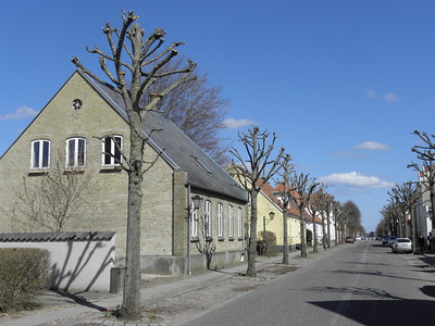
The Moravian Church Settlements are townscapes that resulted from planned idealized Protestant colonies.
From the German village of Herrnhut, the first Moravian missions were directed to northern Europe and Christiansfeld in Denmark is the best-preserved example of such settlements. New Moravian congregations were subsequently established in continental Europe, Great Britain and Northern Ireland (Gracehill), and North America (Bethlehem).
Community Perspective: In Christiansfeld there is a heritage trail with 27 locations that you can follow around town, but it still covers two streets only. Caspar stayed overnight and Jay compares Christiansfeld with a visit to Moravian Bethlehem and Solivagant has covered Gracehill and Matejicek Herrnhut.
Els Slots The Netherlands - 28-Apr-13

In southern Denmark lies a small town where in 1773 the Protestant Herrnhutter started a new church community. Their town plan and characteristic light brick houses have been preserved until today. It is a quiet place where linden trees line the streets on both sides, and where the huge wooden Moravian Church is still the focal point. Christiansfeld a Moravian Settlement is one of no less than three Danish nominations for 2015
The Herrnhutter or Moravian Brethren are a Protestant denomination originating from Bohemia, whose members settled in Saxony (now Germany) after being persecuted in the Catholic Habsburg lands
Read On