Blog WHS website
Updated Tentative Lists H1 2025
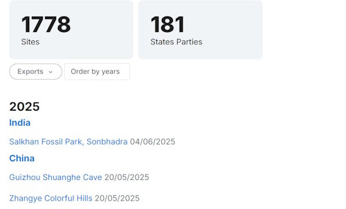
Every morning around 11 a.m. I do a quick check of this direct link to see whether UNESCO has registered any new Tentative Sites. When they do, I try to add the new records to our website as quickly as possible as well. The people in Paris rarely update before 11 a.m., and afternoon changes only occur when they have a lot to add. The Tentative Sites, for some reason, do not appear in chronological order – sometimes they post things that have been submitted months before. Let’s have a closer look at what the crop of the first half of 2025 brought us.
The Numbers
I have written about the trends in Tentative Sites before, trying to determine The Value of a TWHS. So does the first half of 2025 confirm this pattern?
At the time of writing (June 28, 2025), all Tentative Lists combined add up to 1778 sites. In the first half of 2025, 49 new Tentative Sites were added. 9 of those were 1-on-1 replacements of earlier ones. An additional 15 TWHS were removed and became Former TWHS.
49 new ones in the first half of the year are significantly above average, as are the 15 removals. The trend over the last 10 years was that an average of 66 new TWHS were added yearly, with a net result of 30; 66 were added, 14 removed, and 22 were inscribed and thus disappeared from the Tentative List as well.
Full make-overs
Generally, it’s a steady trickle of new sites popping up. But now and then we see full make-overs, where countries are replacing their complete Tentative List. Countries generally don’t seem to like to drastically get rid of outdated entries; they just let them linger forever (looking at you, Egypt!).
- Austria took a bold move in January and removed 8 of its 10 TWHS. It is working on a completely new Tentative List, with only the Iron Trail still in the queue for a WHC (Preliminary Assessment 2025, so 2029?).
- Portugal did something similar, removing 7 older and vague entries from its list, such as the Route of Magellan and Sites of Globalization. But with 11 sites left, there is still plenty to choose from.
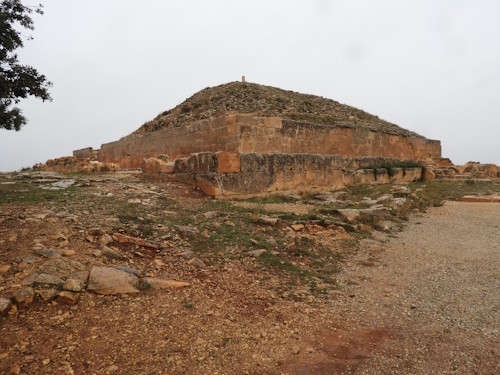
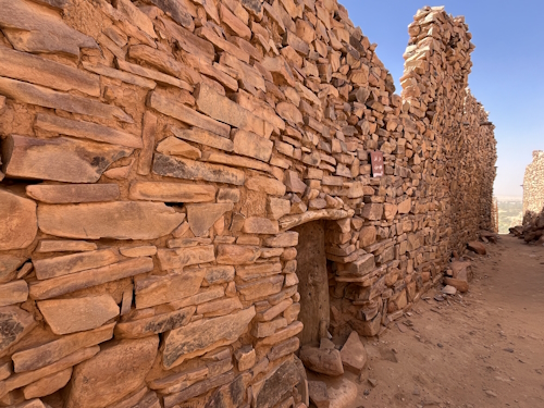
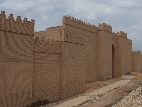
- Algeria refreshed its full list last week. All 6 previous sites were renewed, but seem better defined now. The Royal Mausoleums of Ancient Algeria (photo 2) is its most urgent candidate, possibly going up for nomination in 2027. Also, they included 5 completely new sites, such as the fortified granaries (Ighamaouen) and Djurdjura National Park.
- Guinea did a major update as well, although it couldn’t withstand holding on to some of the old ones. 4 new sites were added.
We also learned that New Zealand is seeking candidates for a new Tentative List; results are expected in 2026.
Notable individual new entries
When we look at the individual new entries, there’s a lot of preparation for upcoming nominations. We see:
- Victorian Goldfields: with a solid budget behind it, this might become Australia's candidate around 2029.
- Belgian Workers’ Assembly Halls: the final candidate of the first group that will take part in the transnational nomination of these Assembly Halls, scheduled for 2028.
- The Mongolian section of the Great Tea Route: as the name already suggests, this is part of a serial transnational effort together with China and Russia, who still have to put forward their candidates.
Among the more imaginative new entries are:
- Phra Prang of Wat Arun Ratchawararam: This is Bangkok's landmark temple complex Wat Arun, and it would lead to a first WHS for this great and popular Asian capital.
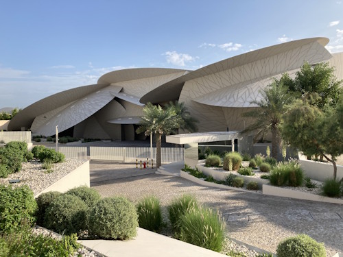
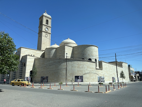
- National Museum of Qatar (photo 3): a 21st-century building, encapsulating a restored older palace. It would become the youngest WHS ever with its opening date of 2019.
- The Secondo-Lido Lighthouse in Mogadishu: overlooking the Indian Ocean and once guiding sailors, merchants and pilgrims, it would be the first WHS of Somalia. Unfortunately, it partially collapsed 2 years ago.
Furthermore, India, China and Türkiye keep on adding and adding individual entries to their already long Tentative Lists without removing any.
Looking at the list of sites added in 2025, are there any Tentative Sites that stand out for you?
Els - 29 June 2025
Comments
Ian Cade 29 June 2025
I had completely missed the Qatar National Museum.
It looks really interesting and I think something that does actually reflect the culture and financial power of the 21st century.
Twobaconsandaboston 29 June 2025
Thank you for your insight. Agree, there certainly large Tentative lists and I can see the local advantage of such. Some more to add to the planning.
Nan 29 June 2025
Yep: Adding to a tentative list is a virtue of itself. Turkey shows Tentative Sites on Location as Unesco sites.
Personally, I dont mind long tentative lists if the tentative sites are worthwhile. At least, in Turkey I found most of the tentative sites I visisted pretty great on their own merit. It's just that they are up for tough competition from the prior Turkish inscriptions.
Els Slots 29 June 2025
And regarding "why each state party does not progress existing TWHS to get their first inscribed site, rather than just adding to the Tentative List?" - in my earlier blog post The Value of a TWHS https://www.worldheritagesite.org/blog/id/498 I suggested that "These unrealistically long T Lists seem to serve mostly a domestic purpose: getting on a Tentative List is already a prize for some local or regional authority within a large country."
Els Slots 29 June 2025
Hi Twobaconsandaboston! There is indeed a strategy to give preference to countries that have not yet had a site inscribed. Within the yearly maximum of 35 new WHS to be discussed, they get a higher priority than the 61st site of Italy. However, this system does not work very well as (a) often there are fewer than 35 new candidates, so no prioritization has to take place, and (b) the 'new' countries often submit dossiers that are either incomplete or lacking (because they are inexperienced or don't have much budget).
Twobaconsandaboston 29 June 2025
I have not digested each site yet to determine if any in particular stand out to me, other than potentially mapping out my visit list. I do note though that both Kuwait and Somalia have continued to add to their tentative lists whilst each of them have yet to have an inscribed site. It may have been covered in other blogs (which I have not found) but is there a trend to prioritise countries nominations that do not have any inscribed sites, similar to the policy (it appears) of prioritising sites in conflict zones? And further I would wonder why each state party does not progress existing TWHS to get their first inscribed site, rather than just adding to the Tentative List? There are only 28 State Parties out of 196 to the WHC that have no inscribed sites.
Blog Countries
Top Tips for Kenya
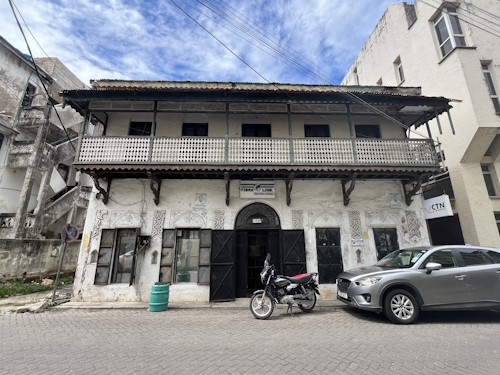
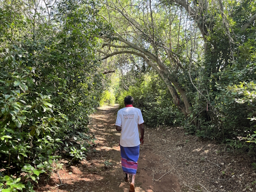
Kenya almost killed me. The murder attempt actually was done by a Kenyan goat, which, while I was walking the streets of Old Mombasa (pictured below), decided to make a run for its freedom and jumped down to street level from a balcony. Its hoof bruised my hand black and blue, but it could as well have landed on my head. It must have been an absurd scene to watch, but the Kenyans aren’t disturbed by a bit of chaos and unpredictability.
Still want to go? Here are some tips for travelling to Kenya as a WH Traveller.
1. Be flexible
Kenya overall is an easy country to travel in: they’re used to tourists, almost everybody speaks English and is willing to help you out (often hoping there’s a little extra in it for them, but not pushing for it). But it certainly doesn’t run like clockwork: departure times of all my 3 domestic flights and the international flight were changed significantly at least once, access to a site that was granted can be revoked for vague reasons (see my Kaya Kauma story), I had an airport transfer who didn’t know how to get to the airport, etc. So be sure to allocate a buffer in both time and money for your trip, as a too-tight schedule might end in missing out on a WHS tick.
2. You need to spice it up a bit
Thematically, there is nothing wrong with Kenya’s set of 8 WHS (a bit of Swahili culture past and present, the Great Rift Valley, Mount Kenya), but they will not bring you to the highlights of Kenya per se. The average rating of its WHS is mediocre at 3.1, and I gave most of the sites between 2 and 3 stars. Visit times were also often short, leaving you to wonder what to do the rest of the day. The set leans more towards cultural sites than natural, and the East Coast seems to be a favoured place to promote. So, especially for a first visit to the country, you might want to spice your itinerary up a bit with a few extra national parks. Notably missing is the Masai Mara, of course, but also habitats further north, such as in Samburu or Meru, could be worth it.

3. Be prepared to go fully digital
To pay for goods and services, Kenyans use M-Pesa as a digital payment system. Even the preacher who came to bless us for a matatu trip to Nakuru accepted tips via M-Pesa. If you’re going to be travelling independently, it’s best to set up your own M-Pesa account (you need a SafariCom physical SIM card). For shorter trips or guided safaris, you can still work your way around it by using cash, a credit card and Wise money transfer.
Also, virtually all parks and cultural monuments can only be paid via the Ecitizen portal. You will already set up an account here when you’re applying for the ETA to get into the country. Ecitizen for foreigners either works or it doesn’t – 90% or so have no problems but there are lots of complaints to be found online; it worked for my ETA but I never got it to function for park payments. The whole system (it is meant for Kenyans to apply for public services such as getting a new passport and all kinds of permits) is way too elaborate to just pay an entry ticket. The workaround is to get a Kenyan to secure a ticket, sometimes at the last step you can then finish it yourself by handing over your physical credit card to the cashier.
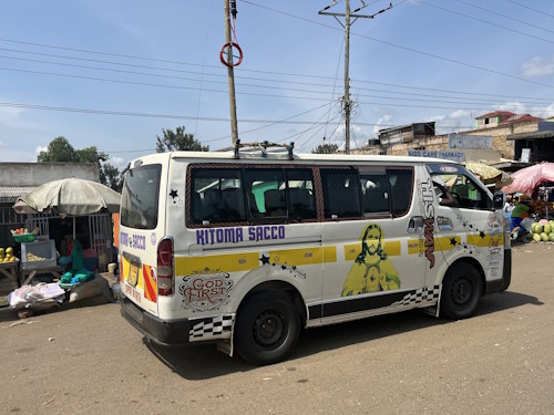
4. Public transport is easy.
Kenya is densely populated, which also means that there is a need for frequent public transport. I mostly used matatus, minibuses (pictured below), which are doable as long as you’re not very tall or have a lot of luggage. They no longer take more passengers than they have seats (the police perform frequent checks) and most of them are express ones, which means no stops en route. They’re hard to beat regarding speed and cost. In the cities, it’s easiest to just jump on the back of a motorbike (boda boda). I was most proud of my 100 KSh (0,70 EUR) transfer (shared taxi) from Kenyatta Airport to the Central Business District in Nairobi, for which the airport taxis normally will ask 20-25 USD. The itinerary that I posted on the Forum shows my route along 7 WHS on public transport. For a comprehensive self-drive one, I recommend the one Zoë posted earlier.
5. Pricing is all over the place
‘Safari’ is the main business of Kenya’s tourism industry, so a Kenya trip can get expensive if you use safari companies to organize it for you (one quoted me 400USD to get to Arubuko Soko Reserve for a day). But the WHS are a whole different cup of tea and most of these sites can be accessed independently. Entrance fees add up to the overall costs due to foreigner pricing, which is routinely applied in Kenya. Especially the National Parks are expensive and they will raise their prices again by the 1st of July. On the other hand, food is inexpensive and the accommodation I found good value for money. Overall, the cost of my 7 WHS fell way below my 650 EUR per WHS limit. I did skip the Lake Turkana WHS, though, for cost reasons and because I think that region deserves more time than a quick one-day in and out.
Els - 22 June 2025
Blog WHS Visits
WHS #974: Mount Kenya
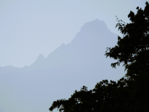
The Community Perspective of our Mount Kenya site page only states: “This site requires an up-to-date review.” – I have hinted at it already several times, wondering how a site that has been ticked by 63 members has only had one, tiny review dating back to 2006. I would guess that 90% of the “visits” here were drive-by ones. Even then, the mountain, with its characteristic rugged, glaciated peaks, isn’t always easy to see, as it is often covered in clouds. This is the best I could get, at 7 in the morning from the pool area of my lodge:
Mount Kenya is known for its several vegetation bands with Afro-alpine flora from the base to the peak. I stayed for 3 nights at the Naro Moru River Lodge, a little oasis outside of the park borders, where you can experience the vegetation and wildlife of the lower regions of the mountain at 1,970m altitude. At night, you may hear the screaming of the tree hyraxes, and during the day, you’ll find many birds typical for the region (the lodge’s bird list includes a significant number of 399 species). The Cinnamon-chested bee-eaters put on a good show, but my favourite was the White-eyed Slaty-Flycatcher with its distinctive white ring around the eyes.
To enter the core zone of the WHS, there are three options: Mount Kenya National Park, Lewa Wildlife Conservancy, and Ngare Ndare Forest. The latter two were extensions and also include the Elephant corridor, where African elephants migrate with the season, away from the mountain when it gets too cold, and back when it gets too dry in the lowlands. They even have an elephant tunnel here, to avoid the main road! I decided against visiting the National Park as any hikes there seemed tough (uphill at high altitude). Lewa Conservancy is a formerly private reserve now owned by an NGO, with only exclusive accommodation on its grounds and very high entrance fees (198 USD per day). So that left me with Ngare Ndare forest, which is managed by a community organization that promotes ecotourism.
I went there with a driver/guide from my lodge. When you see the density of population in this area and the many farms (mostly producing flowers and linseed oil), you will immediately understand what a conservation success it has been that the remaining forest of Ngare Ndare is now protected. We picked up an armed ranger at the entrance, as all exploring here is done on foot and there are wild animals about (including the fairly dangerous elephants and black rhinos). The ranger started by telling that he had to fire a warning shot yesterday when he encountered a family of elephants while guiding a group of tourists. The program offered at Ngare Ndare is fixed: there's a 3km forest hike to a natural pool, and afterwards you will be sent to do the Canopy Walkway. You pay per tourist per day, plus a vehicle and a guide fee (all only collected via M-Pesa). I think you have to announce a few days beforehand that you will be visiting, at least their website suggests so and they need to have rangers available of course.
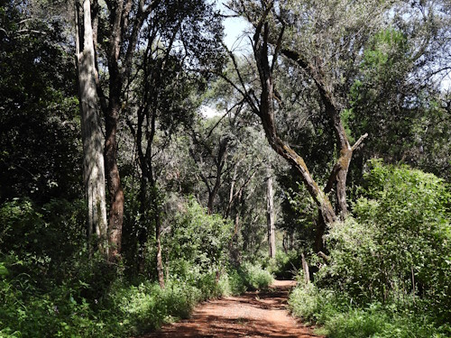
The hike was a bit of a mix of a walking safari and a forest trail. Except for one giraffe, we did not encounter any large animals, but we saw their tracks. They've managed to get the number of black rhinos at the combination of Lewa Conservancy & Ngare Ndare up to over 270 over the years (there were only 74 when the site was inscribed in 2013). Among the trees, the African olive trees and the Red cedars stood out.
I finished my visit at the Canopy walkway (they call it "the bridge"). It seems to have been made from iron wire, like a fence. And it is long, 450 meters. Due to the time of day, we did not see many birds from the bridge, although I came eye-to-eye with a pretty Hartlaub's turaco.
Els - 15 June 2025
Blog WHS Visits
WHS #971: Kaya Forests
The Sacred Mijikenda Kaya Forests along the East Coast of Kenya comprise former fortified settlements (kayas) in an undisturbed forest setting, which still fulfill a sacred role in the belief of Mijikenda peoples. It's such a messy WHS: it is what you get after an AB overrule where the documents haven’t been adjusted to the final decision. When I started preparing for my June 2025 visit, I found out that we had its site history and name (it starts with “Sacred”) all wrong, a rare occurrence nowadays. Originally, it had 36 locations, now there are 8 according to the map section at the UNESCO website, but that’s an error also. Kaya Kinondo was explicitly excluded in the inscription decision. I have alerted the UNESCO WH Bureau to the mistake, but never got a reply and the error persists.
Instead of Kaya Kinondo, which is an easy-to-access site just outside the popular beach resort of Diani Beach, I had to find another Kaya suitable for a visit. All remaining Kayas lie north of Mombasa, so that city or one of the northern coastal towns, such as Watamu, are the best bases. Kaya Kauma stood out immediately as it welcomes visitors regularly as well. I went there on a private half-day tour from Mombasa with Diani Summer Tours.
Kaya Kauma is managed by the Council of Elders of the Kauma people, one of the nine groups that together are known as the Mijikenda. It lies about a 2-hour drive north of Mombasa. My driver started his introduction with “I have never been there, but I have the plan”. Fortunately, he was a persistent guy, because we had barely left the big city when he was called by his contact, the secretary of the Council of Elders. The secretary stated that although a visit was agreed upon beforehand, it wasn’t such a great day as today was a Muslim holiday ánd there had been a death in the village. The driver replied that he had a tourist with him and was coming anyway. Half an hour later, he got another phone call, with the message that the agreed-upon price wasn’t going to do it – the guy from Kauma now demanded 25,000 KSh (about 175 EUR). A ridiculous amount by Kenyan standards, which neither the tour company nor I wanted to pay, but the driver just kept on driving to our target. Later, he got a more reassuring call from another guy from the village near the Kaya (Jaribuni), who said that we could work things out.
The final 12km to the Kaya is on a horrible road that needs a high clearance vehicle and an experienced driver. There’s no signage anywhere, and I guided my driver using Google Maps navigation. In Jaribuni, the local contact hopped in our car and we drove on to the Forest. In the last km, we finally saw a ‘Kaya Kauma – the Sacred Mijikenda Forests’ road sign. We ended up at the edge of the forest where we could park and the Chairperson of the Kaya Kauma Conservation Committee was waiting for us. After a friendly welcome, the financial negotiations restarted. It turned out that the Kauma take a “Bhutanese” approach to tourism: "high-value, low-impact". My driver, who came from Diani Beach, argued that the Kayas in his region (known for mass tourism) are easy to access and against a low fee. The Kauma wanted 25,000 KSh for a visit to the sacred inner area of the Kaya, or 15,000 KSh for a visit to the forest only. I opted for the latter, and we managed to get the price down eventually to 8,000 KSh.
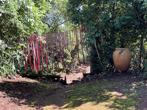
We then followed the Kauma official into the forest. Although all Kayas were made by different groups, they share similar characteristics. One of those is a traditional path, the mwara; usually, there are only two such paths leading to the Kaya. That path first led us past the tree nursery, as the Kauma ‘restock’ the natural forest with plants and trees that bear edible fruits. The forest itself is dense but not very tall. Parts of it are ‘fenced off’ by strips of red cloth. We ended up at the entrance to the sacred area (photo 2), and as agreed, we weren’t allowed to enter. People who may enter have to leave their shoes behind and make an offering in the large jar. The entrance has a whole row of strips of red cloth, plus remains of a stockade that in the past was used to keep strangers out.
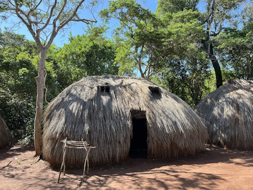
Just in front of the entrance is also the (unmarked) burial place for the clan leaders – our guide said that his ancestors were buried there. A side road led us to a clearing in the forest, where the Kaya Kauma Committee now meets. One elderly man lives there permanently. For him and the use of the committee, four formidable straw huts were built in the traditional manner. They have strong doors made of twigs and even ‘windows’. We sat with the man for a while and talked. A visitor's guestbook was produced: for 2025, I was the 6th person to write in the book. I browsed through it but did not recognize any of the names as WH community members. The years 2023 and 2024 didn’t look much busier than 2025, probably some 20 entries a year. So the site is a clear candidate for our ‘1,000 visitors or fewer’ connection. After 1.5 hours, we said goodbye and went on our way back to Mombasa.
All things considered, it was a memorable visit. I’d love to see reviews of other Kayas coming in at this website: how can they be visited and what was the experience?
Els - 8 June 2025
Blog WHS website
Nomination Dossiers
While preparing for my upcoming Kenya trip, I was studying the Arabuko-Sokoke Forest (part of the Coastal Forests of Kenya TWHS). It turns out that they are looking towards a nomination, but estimate that they would need 100k-300k USD to complete it (and subsequently wondered how they would get access to so much money). The nomination dossiers have also been addressed in the WHC 2025 documents that were published this week, where a change of the format is considered for a myriad of reasons, including "to promote possibly shorter and less costly nomination dossiers".
Maybe it’s time to have a closer look at those Nomination Dossiers (I wrote about Incomplete Dossiers before).
History of the Nomination Dossier
The nomination dossier, as we now know it as an extensive glossy brochure, came into existence in 1998. After the first years of WHS, an overall need to get a grip on several aspects of the nomination process grew. In 1996, a fixed format for nominations was decided upon. That format is mostly still in use, although more specific questions are now being asked about risk preparedness, indigenous peoples, financial resources, etc.
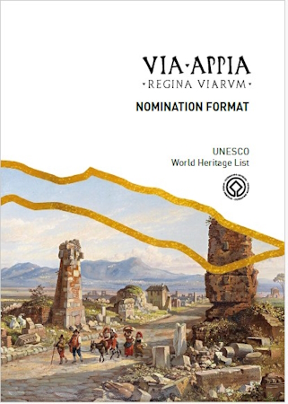
When we look at a few examples of nomination dossiers from the first year, 1998, Semmering sent in 62 pages, Woudagemaal 31, Troy only 12, East Rennell 48, and the Flemish Beguinages 42. Comparing those with those of the successful nominations of 2024, there has indeed been a significant growth in the size of the documents. The number of pages (excluding annexes, maps, management plans) varied from 103 (the emergency nomination of Tell Um Amer) to 751 (Via Appia) and 759 (Marquesas Islands). The average is 286.
The current guidelines found here do expect a dossier to include the following, which sets an expectation for a considerable length:
- Description of the property: "should not exceed 16,000 words (about 50 A4 pages) for a single site nomination or 24,000 words (about 75 A4 pages) for a serial site nomination"
- History and Development: "should not exceed 6,400 words (about 20 A4 pages)"
However, the Operational Guidelines state as well that “Nomination dossiers to the World Heritage List are evaluated on content rather than on appearance of the dossier or the quantity of annexes”.

The cost of a Nomination
The aforementioned 100k-300k USD to complete the nomination of Arabuko-Sokoke Forest probably isn’t only meant for direct costs such as writing the dossier and associated costs such as all the meetings, hiring a professional photographer, map maker etc. There are also costs to upgrade the site and its management to meet the requirements to become a WHS.
A few examples from recent inscriptions seem to confirm that the Kenya estimate isn’t unrealistic. I found the following budget indications (publicized before nomination, so the actual costs may have been higher):
- Eisinga Planetarium in Franeker, a small building that was already well-protected: about 100k EUR (paid 50/50 by city and province).
- Schwerin: 1.2 million EUR (450k from the city, 750k from donations).
- Anticosti Island: $600,000 CAD (= 384k EUR).
- Grand Pré: estimated at $1.3 million CAD (= 832k EUR)
And for upcoming nominations:
- Via Francigena (serial, within Italy): 1.1 million EUR from the Ministry of Culture.
- The Australian government committed $1.2 million (AUD) (686k EUR) to support the Broken Hill and Victorian Trades Halls, part of a larger transnational nomination of Workers' Assembly Halls.
- For the Okefenokee Swamp in the US, an estimated $500,000 USD was raised from private donations and foundations to prepare the UNESCO nomination document, a process that takes three or more years.
Furthermore, the nomination is sometimes taken as an “excuse” to beautify the site, to make improvements that are not necessary to get an inscription. A great example of the latter is Anticosti, where “the province also invested $7.2 million (CAD) to expand visitor accommodations and the municipality is spending $1 million (CAD) on a hiking and cycling trail. The province's decision to end oil and gas exploration on the island, in part to support the bid, also resulted in compensation payments to oil and gas companies, totaling approximately $62 million (CAD).”
The issue with extensive Nomination Dossiers
Back to the Nomination Dossiers: What are the issues?
- Current WHS prospects are held up to standards that the older ones have never been and never will be.
- The high expectations on content and size of the dossiers favor the richer countries.
- They take time from everybody who claims to be overburdened anyway.
- The longer the text, the more false claims and errors will creep in.
Maybe it’s best to go back to the basics and only ask for what is really needed: a simple form, a Draft Statement of Outstanding Universal Value, a clear map; those three items could do the scoping of the potential WHS. Plus some appendices, such as the applicable law that regulates its protection. In the end, the dossiers aren't presenting new scientific results, they’re just reiterating facts that are well-known to the reviewers. And do you write things like Management Plans only for the bid and then leave them in a drawer?
Personally, I only skim the Nomination Dossiers when looking for a specific piece of information. And I remember the one of Qhapaq Nan, which file is so large and the format so unclear that it is hardly usable. Do you ever read a Nomination Dossier? If so, is there one that stood out positively?
Els - 1 June 2025
Comments
Astraftis 4 June 2025
Sometimes I look for the dossiers, especially when curiousity strikes: they are kinds of monographs, if you want, and I like moographs.
I have read only one thouroghly, from thefirst to the last page, though: the dossier for evaporitic carsts in Emilia-Romagna. I think it explained a lot and I ended up wiser after reading it, but I also found it quite dry and with many repetitions. This is an effect I see from being composed bymany different parts, and probably written by a group of people.
I agree that some more concise format would be beneficial for everybody, but I'd still expect something in the order of a masters' thesis. For sure a lot could be delegated to a rich and commented bibliography.
Carlo Sarion 1 June 2025
Ah, this is such a good read Els.
I do read nomination dossiers when I am bored or preparing a trip. A couple of nomination dossiers that I could think of at the moment that I found well-prepared. This is primarily based on a few things: (1) effective in communicating the site's OUV and could convey technical concepts well; (2) written in plain English [definitely no to verbose and euphuistic style of writing for me]; and (3) provides good photos and clear maps.
1. Eise Eisinga Planetarium - the photos(1) and how concise the explanations are
2. 20th century architecture of Frank Lloyd Wright - well-organised methinks
3. Pimachiowin Aki - I thought this one was effective at relating the perspectives and worldview of Anishinaabe First Nations.
I will have a look at others again to add a couple more to the list.
It may also be an interesting discussion to talk about maps that accompany the dossiers. In this day and age of cartographical advancement you'd expect state parties would be able to provide clear and well-rendered maps. But of course, it is very much still a matter of resources and funding.
Blog WHS website
How Can You Participate?
We’ve seen quite a lot of new members to our WH Community over the past year, and I have noticed that it can be hard to find your way around the website as a newbie. The main thing to understand is that this is a community-based website that is driven by Community Contribution. There’s no hidden, paid team behind the scenes that creates all the content. Even the technical side is supported purely voluntarily.
You can contribute to any subject where your expertise or interest lies, and any amount of time is fine. Ways in which you can participate include:
1. Create a User Profile
To become a registered member, it is as simple as creating a user profile. To be shown in Our Community list of members, you will then need to add the number of World Heritage Sites (WHS) you have visited via Update your count. You can use a nickname, but we don’t allow anonymous contributions.
With this account, you’re also eligible to rate the quality of the WHS and Tentative Sites (TWHS) you have visited, which will be reflected in the ‘quality scores’ these sites have. Also, you will be able to vote in polls like the Top Missing or Most Valuable 200 that we have organized in the past.
With a User Profile, you can also get access to the Forum by creating a separate account via the User Dashboard.
2. Write a Review
“Reviews” are the most visible form of community participation on this website. The idea is that you reflect on your visit to a WHS or a TWHS by submitting a short story (300-800 words would be optimal). One of the treasures of this website is seeing the visitor experience to a specific WHS change over the years by reading about visits spanning 20 years or so.
As most sites have been reviewed already many times, try to focus on:
- WHS and TWHS that have not been reviewed yet, or not recently (you can see here which ones are)
- Aspects of WHS and TWHS that have not been highlighted before: a different location, a new way of approach, specific circumstances of the day, updated access information, etc.
Always add a photo (I cannot believe you haven’t got one, it’s 2025) and be as specific as possible. 98% of the reviews will be published, but in times of high supply, the lead time to publication may be up to 3 weeks.
3. Supply Photos
This website's photo policy aims to show original and “meaningful” photos of the (T)WHS. Ideally, all photos shown have been taken by community members.
You can supply main site photos for WHS and TWHS and banner photos, and, if published, your name will be shown in the photo credits. Look at this list (sort on the last column) where we are still missing photos or where you can replace one from the Public Domain. Or at the Looking for Photos topic at the Forum for specific requests.
If you have any photos (full size so not cropped, preferably landscape - horizontal, and no selfies!), please send them via Contact.
4. Be a Detective
Fortunately, the updates on the World Heritage List and Tentative Lists by official sources have become more transparent over the years, but a special goal of our community is to be ahead of the game. We want to know as early as possible how the new Belgian Tentative List will look, or which sites are in the running to be nominated to be in the World Heritage List in 2028.
So some people regularly scour the news (in many languages!) for updates and share them in dedicated topics on the Forum, such as the WHC forecasts and Aspiring to be on the T List.
5. Share WH-related travel details
The place to do it is at the dedicated topic at the Forum of the relevant country. We are especially interested in WHS-focused itineraries and practical experiences. This would also be the place to share a snippet of information about a WHS visit that would not warrant a substantial review. And it is where to seek help, advice, and encouragement from others for your upcoming trip, or just to make sense of the country's (T)WHS.
6. Make Connections
People who enjoy following the World Heritage List often enjoy lists in general. We’ve had a feature called ‘Connections’ for a long time, where we connect at least 3 WHS around a piece of trivia. The Connection Suggestion topic on the Forum is the place to suggest a new connection: announce it publicly, so other people can verify whether they are valid and suggest additions.
7. Improve the geographic data
We have learned that the “official” coordinates, as presented by UNESCO and brought forward by the respective countries, aren’t accurate all the time. So on this website, we aim to present the best possible set of geographic data about WHS and TWHS. With community members travelling to (T)WHS all the time, they are in the best position to verify the geographic locations of the sites. Just alerting to an error in an individual location is already worthwhile.
Soon we will introduce more advanced features, such as displaying the full core zones. While in the past, a simple comment with the coordinates was enough, this is no longer the case. Geospatial data needs to be provided in a standard file format (KML or better GeoJson). You can use tools such as Google Earth or QGIS to create these file types.
8. Find a Plaque
If you’re a true WH nerd, you will spend part of your time at a WHS to find the Plaque. A plaque should be present at every WHS to commemorate its inscription, but they come in many shapes and sizes (or are not there at all). We’ve managed to create a large inventory of these plaques and their locations, and we are always looking for more. It’s best to share a finding on the dedicated Forum topic. A new, original photo of a plaque can be sent to the general contact e-mail address.
9. Participate in a Project
Over the years, we have had projects like “writing introduction texts to all TWHS” to add large amounts of new content to the website. These projects will be announced on the Forum, and you can bring forward ideas for new projects there as well.
10. Organize a meet-up
Travelling to World Heritage Sites together is also fun, and we have had several meet-ups in real life already. We are always open to such initiatives, especially those that will give interested community members access to a site that is hard to visit. Think of sites with restricted access (you gotta know someone to get in) or those that require chartering a boat.
11. Help with the IT side
This website is fully built and run independently, from the operating system upwards. If you have experience with CSS/HTML/JavaScript, Python or Linux hosting and can be a reliable help, please step forward. We are working on the new version of the website and any help is appreciated.
12. Help with the editorial side
The World Heritage topic is very dynamic. For example, think of all the new Tentative Sites that pop up during the year: for each, an introduction text has to be written. Purely from scratch, as (like with the photos) we value originality, authenticity and accuracy. And then there’s the editing of all the connection intro texts and rationales of site connections. These could be much more complete and consistent than they are now. Or interview a WH traveller? So if you like writing texts in your spare time, you’re welcome to lend a hand.
If you're inspired, just dive in! There are tons of things to do. Soon, we will have a Content Management System in place that will support giving community members greater responsibilities as well.
Els - 25 May 2025
Comments
Astraftis 26 May 2025
I am in for any editorial work (it is probably more feasible for me than new reviews currently). And also for any pictures, starting maybe from WWI funerary monuments! :-D
Bernard Joseph Esposo Guerrero 25 May 2025
Let me know how I can be of help, editorial or even with upcoming projects. For meet-ups, any member who is planning to come to the Philippines and making their way up to see Vigan and the Baroque Churches up north, do let me know -- you would be on my turf! Would be nice to be able to host a sizeable meet-up one day!
Blog WHS Visits
WHS #967: Khinalig
Khinalig isn’t visited much by our community – it is too remote to feature on a first itinerary of Azerbaijan. A direct drive from Baku takes 4 hours, so it should be in our Remote Cultural WHS connection. I got there via a day tour from Baku by the Azerbaijan Travel Company (booked via the cheaper GetYourGuide). They run daily group tours with an English-speaking guide, which are surprisingly popular. It included some other short stops as well (Candycane Mountain and the Red Village (the town of the Mountain Jews, where the synagogue now has been closed and is guarded by Azeri soldiers because of Gaza tensions)), but when you go on your own I’d recommend doing Khinalig only as it is by far the most interesting part.
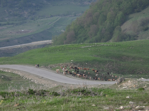
The name of the village and its people isn’t pronounced “Khee-nah-leek” as I had always thought, it is something like “Geh-nuh-leg” (the g as in the guttural Arabic/Dutch g). Despite the town of Khinalig being the obvious focus of the WHS, the core zone is much larger as it also includes both their winter and summer pastures, plus the narrow way between them which is over 200km! I tried to follow on the map whether the access road is part of that zone, but it isn’t: it meanders southeastward through an area with only minor roads. We still saw plenty of sheep and cows being moved around though.
Although there is a paved road nowadays all the way to the village, parts had washed away recently so we still had to rely on 4x4’s getting there. Taxi drivers with 4x4 Lada’s have a good business going on in the city of Quba to provide them. The road seemed doable with any car with a strong engine (our minibus probably was too heavy), but it was quite fun actually to be driven around in an old Lada. It’s still a 50km drive from Quba to get to Khinalig. Most is steeply uphill and there was still plenty of snow in early May, sometimes also covering half of the road. It’s a pretty landscape dominated by U-shaped valleys and mountain meadows.
Khinalig village lies at the top of a hill. The road in the town itself is unpaved and very steep, so you might need to park at the foot of the hill and walk up. A few houses have opened up as guesthouses and a boy was following us around selling knitwear. We had lunch in one of the traditional houses where they had all kinds of local memorabilia hanging on the walls. They showed us a “meteorite”, a very heavy, rounded stone. According to our guide it had fallen from the sky in the 19th century and destroyed some houses, but I have found no evidence to corroborate that. These stones however do feature in the nomination file: they “are considered sacred (“coming directly from heaven”), and they are found in every mosque and shrine in Khinalig. The people pick up the rounded stones that they find in nature and bring them with themselves when they come to the shrines”.
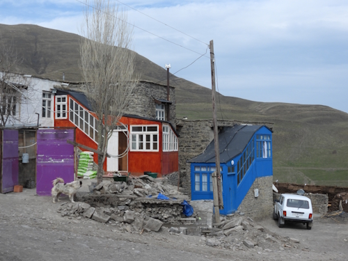
The buildings are mostly made out of local river stones, stacked together with some mud and straw. The roofs are all flat and are accessed via a ladder attached to the exterior – they serve as courtyards for the neighbouring houses. A typical house also has a “glassed gallery” – a wooden structure, now often brightly painted (photo 3), that has a covered staircase and serves as a kitchen and storage area. Cow manure is left to dry everywhere in town and is used for heating.
Before you go and visit, I can recommend reading the nomination file first, as it is very well done (if you ignore some funny misspellings). It explains the cultural landscape of Khinalig better than what you find with your own eyes or from a tour guide. To boost tourism a bit more, I think it would also be beneficial if hikes could be organized to visit some of the shrines, cemeteries, etc. along the migration route.
Els - 18 May 2025
Comments
Astraftis 19 May 2025
With regard to pronunciation, I do not know too much about Azeri, but I find interesting this name has a very Mongolic feel to it, so I wonder about its origin. In that case the initial kh is very similar to the Flemish g as in "zegt". Anyway, I just discovered that Khinalug language is a Northeast Caucasian one, and they call that place "catch"!
But yeah, Azeri has a posterior vowel harmony in that word and those i's are actually dotless ı, more similar to a schwa.
CugelVance 18 May 2025
A couple if years ago I visited Khinalig with a russia tour group as a day-trip from Baku.....the female tour guide was totally incompetent but she gave us plenty of time to discover Khinalig and we made quite a lot of stops around that mountain village.
Funnily, Khinalig didn't impress me much and not much is still there in my memory.However,the russian group was extremely nice and warm-hearted.All in all a wonderful day-trip despite the totally useless tour guide
Blog Connections
In the Red Zone
Nan told me we need more icons alerting to WHS with specific Visiting Conditions. Dodging his request for ‘WHS with biosafety hazards’, I have settled for ‘Do Not Travel: WHS in the Red Zone of travel advisory systems’. Most Western countries apply such a system, supported by a public website, that advises their citizens about travel to foreign countries. These advices include up-to-date visa, customs and health information (usually more reliable than what you’d find in private sources). Still, they are mostly known for their overall advice often given in Red, Orange, Yellow and Green. Red means “Do not Travel”.
Pros and cons of the travel advisory systems
While many experienced travellers take this advice with a pinch of salt, others are more cautious and like to be aware of the specific risks involved in travelling to a certain country. A contributing factor is that most general travel and health insurance companies use the system to determine whether your insurance is valid in the country/region.
Criticisms of these advisories in general include:
- The application of double standards to "friendly" countries (debris from missiles flying overhead is an issue for Iraq and Iran, but apparently not for Jordan, which lies on the same flyway).
- Outdated / bearing a grudge for decades (a single incident in 2014 will be in a warning text forever).
- Not being specific within a country (often whole countries are struck out, while on the ground parts of it are significantly safer than others).
To compile the connection, I have used the travel advisories of Germany and Australia. When both issue a Do Not Travel warning, I have included the WHS. The choice of Germany and Australia may seem arbitrary, but they both have an extensive system in place, are on the strict side (more so than NL or UK for example), and their citizens are less specifically targeted abroad than those of the USA, UK and France so they might offer a more general perspective. I have also had a look at a non-Western advisory, that of India, but it is too limited for our purposes.
The German system does not use colour coding and has no maps. It uses the term “wird gewarnt” instead to indicate the highest level of warnings. But its descriptions of the risks and the areas involved are very specific. For both the Australian and German systems, I think it would be better if they’d explicitly name tourist sights (such as Lalibela) instead of referring only to provinces or geographic features (“North of the Benue river”).
Fully off-limits countries
The following countries, including all of their WHS, have been earmarked “Do not Travel” and are thus fully off-limits:
- Afghanistan
- Belarus
- Central African Republic
- DRC
- Haiti
- Iran
- Libya
- Mali
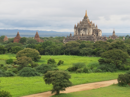
- Myanmar (photo 1 shows Bagan)
- Niger
- Palestine
- Sudan
- Syria
- Ukraine
- Yemen
Together, they represent 81 WHS (6.6% of the total).
WHS in affected areas
In addition, the following WHS lie in parts of countries marked as “Do not Travel”:
- Algeria: Tassili N’Ajjer (border area with Libya)
- Benin: W-Arli-Pendjari Complex
- Burkina Faso: all WHS (Germany "allows" you to travel to the big cities)
- Cameroon: Sangha Trinational, as it is in the border region with the C.A.R.
- Chad: all WHS (Germany "allows" you to travel in the south)
- Cote d'Ivoire: Comoé NP
- Ethiopia: Lalibela, Fasil Ghebbi, Bale Mountains, Aksum, Simien NP (less clear in the German advice, but implied)
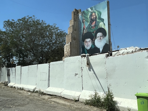
- Iraq: all but Erbil Citadel (photo 2 shows the Welcome to Samarra)
- Lebanon: Baalbek, Anjar, Tyre
- Nigeria: Sukur (not clear in German but implied)
- Pakistan: Takht-i-Bahi (all in Khyber Pakhtunkhwa Province)
This brings the total up to 103 WHS (8.4%).
Differences in severity
I found several differences between the Australian and German recommendations. In all cases, Australia was stricter / less precise. This includes:
- Benin: Koutammakou (North Benin starts already at the city of Natitingou, according to Australia)
- Colombia: Los Katios (Australia warns against both sides of the Darien Gap)
- Cote d'Ivoire: Sudanese style mosques (Germany only warns against the Northeast, Australia has the Northwest as well)
- DPRK: Australia bans all of the DPRK, Germany does not
- Iraq: Erbil (Australia advises against travel to Iraq Kurdistan as a whole)
- Lebanon: Australia warns against all, Germany only far south and east (Tyre, Baalbek, Anjar)
- Mauritania: Australia avoids the Ksour of Chinguetti, Ouadane (photo 3), etc, while Germany draws the line further northeast
- Panama: Darien NP (Australia warns against both sides of the Darien Gap)
- Russia: Australia bans all Russia, Germany does not
- Venezuela: Australia bans all Venezuela; Germany does not
Does your country have a travel advisory system, and do you see significant different conclusions from those above?
Els - 11 May 2025
Comments
Els Slots 17 May 2025
Thanks Philipp! The Swiss system seems similar to the German one.
Philipp Peterer 16 May 2025
Switzerland has them of course. Never checked them out as I am usually not visiting risky countries. https://www.eda.admin.ch/eda/de/home/vertretungen-und-reisehinweise/laenderunabhaengigereiseinformationen.html
Astraftis 12 May 2025
Ah! I didn't check DPRK, and I wasn't expecting it. To be more precise, the wording is that Italian citizens are "blocked2 from going there. Apparently there is no diplomatic mission between the two countries and I understand it is simply not possible to get a visum.
Solivagant 12 May 2025
Following the comment below by Afraftis I had a look through th Italian site he mentioned....indeed Italy doesn't seem to go higher than "not recommended"....
"It is recommended to postpone all travel to the Russian Federation."
Palestine - " compatriots are recommended to postpone their trip, unless dictated by compelling reasons that cannot be postponed."
"all travel to Sudan is not recommended."
" Travel to Myanmar is not recommended"
EXCEPT .....amazingly ...... for DPRK
"At the moment, Italian citizens are prevented from traveling to the country." ("Al momento, per i cittadini italiani, resta preclusa la possibilità di recarsi nel Paese.")
Astraftis 11 May 2025
Italy has Viaggiare Sicuri "travel safely" (https://www.viaggiaresicuri.it/), which does not use colours. It is rather discursive in the explanations and I think it does a rather good job. For most of the countries in this post it says that "travelling is disouraged". The situation is described with quite some detail, highlighting unsafe regions. For Belarus and Russia traveling is also "discouraged", but then it is said that they are safe, so the political reasons are made explicit, while for Burma and Sudan it's pretty clear you have nothing to do there. I don't know anything particular about insurances.
The style of this official source is probably very, very cautious and a little exaggerated. It can make me wary even of a trip to Lithuania... Of some places like Brazil it does not discourage travelling, but it gives a very bleak image which I'd say could keep most visitors away. Anyway, I think that local operators are also a good source: mine for Sudan was very clear in stating where we could or could not organise a trip, and I had a good feeling of responsibility on their side.
Twobaconsandaboston 11 May 2025
Thanks Els, Thought provoking as always. I think the key to this is that these country assessments are "Advisory" and that each individual still needs to undertake their own research and assess their own situation and experience. One key area though for me is travel Insurance costs, which can be a kicker and I won't travel without it.
Wojciech Fedoruk 11 May 2025
Poland has it and I consider it very strict. But, there are significant differences comparing to these two. E.g. all Mauritania and Ivory Coast is only orange, while many other countries are considered red in parts, e.g. Uganda near DRC
border (Bwindi), Lamu and Turkana in Kenya, etc.
Blog Countries
Top Tips for Travelling to Iraq
My first visit to Iraq was in 2014, when I covered semi-autonomous Iraqi Kurdistan. In April 2025, I went to what in tourism is known as ‘Federal Iraq’ (although that would be a more appropriate name for the entire country, including the Kurdish governorate). As it covers the major sites of Ancient Mesopotamia, it is definitely the most interesting part and it holds 5 out of the country's 6 WHS. Herewith are some tips for travelling to Iraq as a WH Traveller.
1. Don’t expect it to be pretty
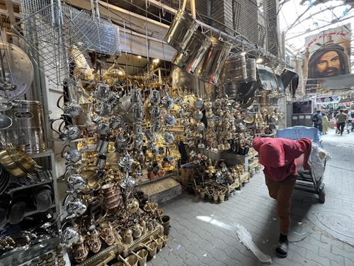
Most of it is a typical flat Arab desert landscape, littered with plastic waste. The monuments generally also lack the refinement and colour of those in neighbouring Iran. Unless roadside portraits of Shia clerics particularly enamour you, your best bet for beauty are the statues and sculptures in the National Museum in Baghdad.
2. The safety situation normalizes rapidly
Many western countries (such as Germany, Australia, USA) still raise a red flag for all travel to Iraq, although the UK, for example, has lowered its warnings for the southern areas, including Baghdad, Babylon, Najaf, and the Marshes. On the ground, it all feels calm and safe and the people are friendly to foreigners, no matter where they are from. Nowhere does it feel oppressive, and you can walk the streets freely. Our local guide said that it had been like this for about 4-5 years, and that it normalizes more and more every quarter. The only reminder of worse times is the high number of checkpoints along the roads between governorates and while entering cities. These do slow you down a bit, but we passed all without incident within a few minutes and they never did look at us individually (just a chat with the driver/local guide and browse through a selection of the passports).

3. There’s a lot of potential for more WHS
The coverage of the most important periods in Iraqi history is fairly balanced, but 6 WHS isn’t a lot for a country of its size and importance (Iran has 28 WHS!). I think Iraq can easily have 8-10 more. Ordered by historical period, candidates are:
- Prehistory (0): the Shanidar Cave as an important Neanderthal site (one of the largest single-site collections of Neanderthal fossils ever found), not on T List but also a prominent role in the Iraq National Museum.
- Ancient Mesopotamia (3): Sumerian at Ur/Uruk, Assyrian at Ashur, Neo-Babylonian at Babylon. Well-covered, but as it is Iraq’s unique specialty, maybe Nineveh, Nimrud or Nippur could be added as well (though these are in a poor state).
- There’s nothing from the 2 centuries-long rule of the Persian Achaemenids: worth a mention here are the rock-cut tombs of Qizqapan in Kurdistan region.
- Classical Antiquity (1): the Parthians at Hatra, but there’s none from the Sassanids, this should be covered by Ctesiphon (not on T List).
- Islamic Conquest (1): Abbasids (Samarra), could/should have Old Baghdad too.
- Turkic and Mongol dynasties (0): the TWHS Old City of Mosul should cover this, as its landmark mosque is from the Turkic Zengic dynasty.
- Ottoman Empire (1): Erbil WHS has an Ottoman street plan. The Baghdad and Mosul sites also have significant Ottoman remains.
- 20th century (0): could be covered by some sites in continuous use, such as the Yezidi Lalish Temple or the Wadi Al-Salam Cemetery in Najaf (both on T List)
4. Other factors have caused more lasting damage than the 2003-2017 wars
Any damage from the 2003 Invasion and the subsequent Iraqi Civil War on the Iraqi (T)WHS now seems to have been erased or at least patched up as best as they could. Even the impact of the ISIS iconoclasts in the end was fairly limited: only Mosul and Nimrud still show the signs. Still, the state of conservation of all sites leaves a lot to be desired. A particular Iraqi problem is what to do with the unbridled reconstructions of poor quality, which were popular during the Saddam era. ICOMOS seems to suggest that removing them would be best in the end, but that would be a hell of a job. Babylon (photo 3) is covered with them and also at other sites, they are prominently visible. I also found it remarkable how little excavation work has been done at virtually all sites. Site interpretation is generally quite poor too, so better to read up beforehand.
Els - 4 May 2025
Blog TWHS Visits
Old City of Mosul
The northern city of Mosul is the odd one out among the Iraqi (T)WHS. On the one hand, it is probably the one most severely damaged during the recent conflicts (though nearby Nimrud has been hit hard as well). On the other hand, it is the only one that has been subject to a full-scale international rescue mission, which has also brought in internationally accepted restoration and conservation standards.
The Old City of Mosul stands for a thus far unrepresented part of Iraqi history: that of the Turkic-Mongol invasions (though a nomination will also include its Ottoman remains). The Turkic Zengid Dynasty ruled the area of northern Iraq and Syria from Mosul from 1127–1222. The city, located along the major trade routes of the time, was known for its metal craftsmanship and miniature painting. The main monument left from this period is/was the Al-Nouri mosque and its leaning minaret.
Unfortunately, it was exactly this mosque that was blown up by ISIS during their retreat from Mosul. Their black flag had been flying from the minaret since Abu Bakr al-Baghdadi claimed the Caliphate from here in 2014. After losing the Battle of Mosul in April 2017, they blew it up with explosives in a “final act of angry defiance”.
The first impression of the Old Town in April 2025 is still one of devastation (photo 1). The area along the West Bank of the Tigris is in total ruins and part of it has already been bulldozed. The narrow alleyways of the Old Town had been used to fight a guerrilla-style war during the Battle of Mosul. This is where the Ottoman-era quarter is – probably more so in layout than authenticity of the buildings, as most looked not that old to me (plenty of concrete). All standing buildings have been cleared of explosives, but there seems to be no fixed plan for what to do with them.

The Al-Nouri mosque lies a few blocks more “inland” in the core of the city and it was its main mosque. The mosque complex is still fenced off like a construction site, but we were allowed to enter after registering our names on a list with site security. The minaret has now been fully restored, in all its former leaning glory, “like a man bowing”. It’s also impressively tall. The local community had been polled on whether to rebuild the minaret as it was, or leave it in ruins to remember what happened; 94% of the population wanted the monument as it was before. They’re still working on the mosque itself – the interior of the building (which wasn’t as “authentic” as the minaret anyway, as it had been rebuilt many times) still needs a lot, though the massive marble columns are of interest. They’ve also stumbled upon older versions of the mosque underneath and will make those findings visible as well.
Another notable aspect of Mosul has always been the co-existence of different cultural groups. There are several churches in the city center, of different denominations. Like the Al-Nouri mosque, the Notre-Dame de l’Heure convent and the Tahera Church are part of the ‘Revive the Spirit of Mosul’-project. Kick-started with a donation of 50 million USD by the UAE in 2018 and a further 48 million USD by the EU, UNESCO, Iraq's culture ministry, and ICCROM work together in restoring these monuments. The Dominican Notre-Dame de l’Heure convent looks as good as new (photo 3) and work on the Tahera Church has just been completed as well (we weren’t allowed to enter that one as the priest was afraid we would stain the carpets before the upcoming grand opening). The Dominican convent is quite impressive, with stained glass windows and a rooftop from where you’ll get good city views. Religious activity is only occasional – there are hardly any Christians left in Mosul city, although there are more in villages in the surrounding Nineveh Governorate. The Revival Project also tries to revitalize a small heritage quarter with a museum and some Ottoman mansions.
Before I read up on it, I hadn’t been aware how big the ‘Revive the Spirit of Mosul’-project is in a UNESCO context – it is said to be the largest initiative carried by UNESCO since the Abu Simbel move in the 1960s. Funding has reached 115 million USD. So, good news for Mosul, and they may even have it listed as a WHS in a couple of years. But the cynic in me wonders about whether the Shia-dominated parts of Iraq aren’t worthy of foreign investments either. Mosul is a purely Sunni city, which probably explains why the UAE were so quick to throw money at it. The EU has listed anti-terrorism and the coexistence of different religions as two of the main reasons to support the project so generously – it provides lots of local jobs and gives the place its pride back.
Els - 27 April 2025
Blog Index
Books
- Book: Seven Wonders (21 July 2024)
- Book: Saving Yellowstone (10 September 2023)
- Book: Natural Wonders of the World (30 July 2023)
- Book: Heaven on Earth (21 May 2023)
- Book: World Heritage Craze in China (26 March 2023)
- Possible Antarctic WHS (5 February 2023)
- Book: Cultural Heritage and Mass Atrocities (25 September 2022)
- Book: India: UNESCO World Heritage Sites (3 April 2022)
- Book: Great World Wonders (7 November 2021)
- Book: Chinese Heritage Sites and their Audiences (13 June 2021)
- Book: Coastal WHS (3 January 2021)
- Book: Atlas Obscura (10 February 2019)
- The Rebirth of Bodh Gaya (10 February 2018)
- Books: Modern African Architecture (18 February 2017)
- Books: Wonders of the World (28 November 2015)
- Book: Chasing 193 (8 July 2015)
- Book: The Heritage Universe (27 June 2015)
- Book: Japan's World Heritage Sites (26 October 2014)
Connections
- In the Red Zone (11 May 2025)
- One Million - Updated (20 April 2025)
- A closer look at Rock Cut Art (6 April 2025)
- The Most Remote Cultural WHS (13 October 2024)
- The World’s Greatest Natural Areas (6 October 2024)
- Spice (Route(s)) WHS (18 August 2024)
- Connected (14 July 2024)
- Top Neolithic WHS (7 July 2024)
- Strict Nature Reserves (12 May 2024)
- Centres of Plant Diversity #2 (14 April 2024)
- Centres of Plant Diversity (17 March 2024)
- WHS in TCC Territories (25 February 2024)
- Gorilla (T)WHS (28 January 2024)
- Foreigner Pricing Analysis (14 January 2024)
- Best Visited on a Bicycle (19 November 2023)
- Minor Boundary Modifications (29 October 2023)
- Smaller than they seem (20 August 2023)
- Himalaya (4 June 2023)
- One thousand visitors or fewer (23 April 2023)
- Canopy Walkways (2 April 2023)
- Invention of sweets and pastries (22 January 2023)
- Transnational WHS in the making (16 October 2022)
- Obelisks (21 August 2022)
- Threatened by Oil and Gas Exploration (7 August 2022)
- Byzantine (24 July 2022)
- Critically endangered fauna species (12 June 2022)
- Petrosomatoglyphs (1 May 2022)
- Fossil sites (17 April 2022)
- Cable cars (27 March 2022)
- Erotic Art (19 December 2021)
- Silk Road(s) (14 November 2021)
- Diluted by an Extension (31 October 2021)
- WHS and Beer (12 September 2021)
- Buildable in Lego (22 August 2021)
- WHS Hotspots (15 August 2021)
- WHS affected by Poaching (2 May 2021)
- Epic Subtitles (7 March 2021)
- No Road Access (28 February 2021)
- Expressionist Architecture (17 January 2021)
- Cold War (20 December 2020)
- Dependent Territories (29 November 2020)
- Mammal WHS (15 November 2020)
- Bird Migration WHS (24 May 2020)
- WHS in classic documentaries (12 April 2020)
- Unusual Entry Requirements (29 March 2020)
- WH Travel & Passports (1 December 2019)
- Railway WHS (1 September 2019)
- Why people die at WHS (21 April 2019)
- The Umayyads (17 March 2019)
- Historical Graffiti (3 March 2019)
- Viewable from another WHS (9 June 2018)
- One million or more (3 March 2018)
- WHS On Banknotes (16 December 2017)
- A Silk Roads overdose? (20 November 2016)
- A History of WHS in Danger (5 September 2015)
- WHS & World War I (19 October 2014)
Countries
- Top Tips for Kenya (22 June 2025)
- Top Tips for Travelling to Iraq (4 May 2025)
- Most Difficult Countries to visit a WHS in (23 February 2025)
- Top Tips for Senegal and The Gambia (26 January 2025)
- Top Tips for India (15 December 2024)
- Top Tips for the wider Veneto Hotspot (20 October 2024)
- Top Tips for Japan (29 September 2024)
- Completing Norway (30 June 2024)
- Top Tips for Travelling to Kazakhstan (16 June 2024)
- Top Tips for 15 days in China (2 June 2024)
- Top Tips for Pakistan (24 December 2023)
- Top Tips for Saudi Arabia (3 December 2023)
- Top Tips for Zimbabwe (1 October 2023)
- Top Tips for Madagascar (9 July 2023)
- Tips for Travelling to Western Turkey (14 May 2023)
- Tips for Travelling to Northern Brazil (8 January 2023)
- Tips for Travelling to Chad (20 November 2022)
- Top Tips for Eastern Canada (10 July 2022)
- Top Tips for Tunisia (29 May 2022)
- Top Tips for Northern Mexico (27 February 2022)
- Best Countries (23 January 2022)
- Tips for travelling to Kyrgyzstan (17 October 2021)
- Tips for travelling to Costa Rica (25 April 2021)
- Tips for travelling during a pandemic (14 March 2021)
- Tips for travelling to Iceland (20 September 2020)
- Tips for travelling to Colombia (16 February 2020)
- Tips for travelling to Russia (27 October 2019)
- Tips for travelling to Georgia (4 August 2018)
- Tips for travelling to the Gulf (2 May 2018)
- Value for money WH countries (24 March 2018)
- Tips for travelling to Namibia (3 February 2018)
- Tips for travelling to Ecuador (14 October 2017)
- Tips for travelling to Egypt (30 April 2017)
- Tips for Azerbaijan and Iran (3 June 2016)
- Tips for Rwanda, Congo and Uganda (30 January 2016)
- Tips for Travelling to Myanmar (31 October 2015)
- Mongolia's Tentative List (28 February 2015)
- How to visit the (T)WHS of Sudan (22 November 2014)
Exhibitions
- Unveiling the Stoclet House (7 April 2024)
- Rietveld Bike Tour (26 November 2017)
- Looking for the Golden Rhino (4 December 2016)
- Vestfold Ship Burials (18 June 2016)
- Rome. Emperor Constantine’s dream. (22 November 2015)
- Carthage (8 March 2015)
TWHS Visits
- Old City of Mosul (27 April 2025)
- 2025 WHC: Carnac (23 March 2025)
- Workers' Assembly Halls (Belgium) (10 November 2024)
- Sites of the Busan Wartime Capital (1 September 2024)
- San Pedro de Atacama (24 March 2024)
- Fell and Pali Aike Caves (10 March 2024)
- The Underwater City of Port Royal (18 February 2024)
- Uch Sharif (17 December 2023)
- Hejaz Railway (26 November 2023)
- WHC 2023: Kuldīga (6 August 2023)
- Gordion (7 May 2023)
- Íznik (30 April 2023)
- Niah Caves (19 March 2023)
- Banteay Chhmar (19 February 2023)
- Via Appia (30 October 2022)
- Valentia's Transatlantic Cable Ensemble (23 October 2022)
- Civita di Bagnoregio (9 October 2022)
- Zagori & Pindos (11 September 2022)
- Talayotic Minorca (21 November 2021)
- Kyrgyz Silk Roads: Uzgen (10 October 2021)
- Historic Center of Parma (29 August 2021)
- Bachkovo Monastery (18 July 2021)
- Mosaics of Philippopolis (11 July 2021)
- Prince-Bishops' Palace in Liège (20 June 2021)
- Lower German Limes: Berg en Dal Aqueduct (30 May 2021)
- Corcovado NP (11 April 2021)
- Guayabo National Monument (24 March 2021)
- San José (21 March 2021)
- Buenos Aires 1880-1920 (21 February 2021)
- The Egyptian Museum (14 February 2021)
- The Meuse Citadel of Namur (7 February 2021)
- The Neanderthal fossil sites of Wallonia (24 January 2021)
- Plantations in West Curacao (13 December 2020)
- Unreviewed TWHS: Hirkan Forests (22 November 2020)
- Sanxingdui in 2007 (8 November 2020)
- Archipelago of La Maddalena (25 October 2020)
- Bouches de Bonifacio (18 October 2020)
- Nice (4 October 2020)
- Mediterranean Alps (27 September 2020)
- Icelandic Turf House Tradition (13 September 2020)
- Mývatn and Laxá (30 August 2020)
- Fjallabak (23 August 2020)
- Old Wastewater Treatment Plant (16 August 2020)
- Mértola (5 August 2020)
- Vila Viçosa (2 August 2020)
- Works of Álvaro Siza (19 July 2020)
- Great Spas: Bad Ems (28 June 2020)
- ShUM city of Worms (21 June 2020)
- Chapultepec (7 June 2020)
- Frederiksoord-Wilhelminaoord (17 May 2020)
- Tuol Sleng Genocide Museum (3 May 2020)
- Unreviewed TWHS: Lalish Temple (26 April 2020)
- Unreviewed TWHS: Bahoutdin Complex (5 April 2020)
- New Dutch Waterline (22 March 2020)
- WHC 2021: The Slate Landscape (15 March 2020)
- Unreviewed TWHS: Tansen (8 March 2020)
- Sarlat at Night (1 March 2020)
- Salt Town of Nemocón (5 January 2020)
- Virgilio Barco Library (29 December 2019)
- Irkutsk (20 October 2019)
- Staigue Stone Fort (25 August 2019)
- The Royal Sites of Ireland: Cashel (18 August 2019)
- Hospital of Our Lady with the Rose (11 August 2019)
- WHC 2019: Krzemionki (30 June 2019)
- Chobe (2 June 2019)
- WHC 2021: Sarnath (5 May 2019)
- Olive Grove Landscape of Lucena (14 April 2019)
- Lower German Limes: Xanten (31 March 2019)
- Harran and Sanliurfa (24 March 2019)
- Padova Urbs Picta (10 March 2019)
- WHC 2019: Paraty Culture and Biodiversity (24 February 2019)
- WHC 2019: Walled City of Jaipur (17 February 2019)
- Ancient Quanzhou (26 January 2019)
- Yen Tu: Vinh Nghiem Pagoda (5 January 2019)
- Roman heritage of Nîmes (1 December 2018)
- Raoudha Nilometer (24 November 2018)
- WHC 2019: Danube Limes - Arrianis (31 October 2018)
- Uplistsikhe Cave Town (21 July 2018)
- Tbilisi Historic District (14 July 2018)
- David Gareji Monasteries (23 June 2018)
- Fortress of Ananuri (16 June 2018)
- Gdansk - Town of Memory and Freedom (2 June 2018)
- WHC 2018: Žatec, Town of Hops (12 May 2018)
- Ore Mountains (5 May 2018)
- Dubai Creek (28 April 2018)
- Sharjah: the Gate to Trucial States (18 April 2018)
- Forts of Rostaq and al-Hazm (4 April 2018)
- Teylers (17 March 2018)
- WHC 2019: Plečnik in Ljubljana (17 February 2018)
- Etosha Pan (10 January 2018)
- Benguela Current (5 January 2018)
- Fish River Canyon (1 January 2018)
- Lechner's pre-modern architecture (9 December 2017)
- WHC 2018: Chaîne des Puys (18 November 2017)
- Hoge Kempen Transition Landscape (21 October 2017)
- Mathildenhöhe (19 August 2017)
- Mid-Atlantic Ridge (6 July 2017)
- Ptolemaic Temples (21 April 2017)
- Kuwait Towers (31 March 2017)
- WHC 2017: Dilmun Burial Mounds (11 February 2017)
- Palau and the Yapese Stone Money (7 January 2017)
- Tet el Bad (Stone Coffin) (1 January 2017)
- Hanyangdoseong (29 December 2016)
- Zadar - Romans and Venetians (12 November 2016)
- Nelson Mandela Legacy Sites (19 October 2016)
- Ngwenya Mines (12 October 2016)
- 1940's - 1950's Architecture of Minsk (7 September 2016)
- 20th Century Ivrea (13 August 2016)
- Waterloo (30 July 2016)
- Agricultural Pauper Colonies (9 July 2016)
- Masouleh (25 May 2016)
- Sheki, the Khan's Palace (2 May 2016)
- Temple of Fire (24 April 2016)
- Fortress Town of Palmanova (12 March 2016)
- WHC 2016: Rediscovering Dosan Seowon (13 February 2016)
- WHC 2016 – Corbusier’s Villa Savoye (7 February 2016)
- Mgahinga – Where Gold Meets Silver (9 January 2016)
- Rwandan Genocide Memorial Sites (29 December 2015)
- WHC 2016: Cetinje (5 December 2015)
- WHC 2016: Ani Cultural Landscape (13 November 2015)
- Sonian Forest’s Beech Cathedral (7 November 2015)
- Ancient cities of Upper Myanmar (24 October 2015)
- Bagan Archaeological Zone (17 October 2015)
- Konbaung Wooden Monasteries (9 October 2015)
- WHC 2015: Christiansfeld (20 June 2015)
- The Mystery of Kokino (14 June 2015)
- Amphitheatre of Durres (3 June 2015)
- WHC 2015: Champagne (14 May 2015)
- WHC 2015: Palermo, Cefalù & Monreale (9 May 2015)
- Two TWHS in Antwerp (6 April 2015)
- Five Dzongs of Bhutan (14 March 2015)
- Granada and its natural environment (20 February 2015)
- Volcan Masaya - Exciting or not? (14 February 2015)
- WHC 2015: Singapore Botanic Gardens (20 December 2014)
- Old Dongola (1 December 2014)
- Great Spas of Europe: the original Spa (15 November 2014)
- WHC 2015: Hagi Castle Town (9 November 2014)
Travel in general
- Travel Windows of Opportunity (30 March 2025)
- Trip Budgeting (31 March 2024)
- Parallel planning of multiple trips (27 August 2023)
- My experience travelling ultra-light (20 March 2022)
WH Travellers
- Tours to WHS (9 February 2025)
- TWHS Masters (2 February 2025)
- The Quest for 1,100 visited WHS - Year 3 (5 January 2025)
- Drive-by Visits (22 December 2024)
- Maddeningly Close (3 November 2024)
- WHS-ers do Tassel (4 August 2024)
- Getting a Stoclet Pass (23 June 2024)
- Learning from the Birders (28 April 2024)
- Completing Countries (4 February 2024)
- The Quest for 1,100 visited WHS - Year 2 (7 January 2024)
- The Value of a TWHS (16 July 2023)
- The 9 WHS Commandments (5 March 2023)
- Nine things I learned in my first year of full-time travel (1 January 2023)
- Revisit needed (27 November 2022)
- Shandos ... planning a WH trip to South America (2 October 2022)
- Michael Ayers ... cycling to over 300 WHS (5 June 2022)
- WH Travel Focus (10 April 2022)
- The quest to 1100 visited WHS in 2030 (2 January 2021)
- Wojciech and Thomas ... In Iraq (28 November 2021)
- Zos M. ... Completing China (24 October 2021)
WHS Visits
- WHS #974: Mount Kenya (15 June 2025)
- WHS #971: Kaya Forests (8 June 2025)
- WHS #967: Khinalig (18 May 2025)
- WHS #958: Umm Al-Jimāl (13 April 2025)
- WHS #957: Djerba (16 March 2025)
- WHS #956: Cidade Velha (16 February 2025)
- WHS #951: Saloum Delta (19 January 2025)
- WHS #946: Banc d'Arguin (12 January 2025)
- WHS #941: Mahabodhi Temple (8 December 2024)
- WHS #939: Kaziranga (1 December 2024)
- WHS #936: Indian Sundarbans (24 November 2024)
- WHS #932: Champaner-Pavagadh (17 November 2024)
- WHS #926: Ogasawara Islands (22 September 2024)
- WHS #925: Sado Gold Mines (15 September 2024)
- WHS #924: Shiretoko (8 September 2024)
- WHS #909: Tanbaly (9 June 2024)
- WHS #904: China Danxia (26 May 2024)
- WHS #903: Mount Wuyi (19 May 2024)
- My #900: Roșia Montană (21 April 2024)
- WHS #894: Los Alerces National Park (3 March 2024)
- WHS #886: Sangha! (21 January 2024)
- WHS #880: Makli, Thatta (10 December 2023)
- WHS #875: Erfurt (5 November 2023)
- (T)WHS of New York City (22 October 2023)
- WHS #872: Poverty Point (15 October 2023)
- Chicago Meetup (8 October 2023)
- WHS #850: Mana Pools (17 September 2023)
- WHS #848: Great Zimbabwe (3 September 2023)
- WHS #846: Tsingy de Bemaraha (2 July 2023)
- WHS #845: Royal Hill of Ambohimanga (25 June 2023)
- WHS #844: Rainforests of the Atsinanana (18 June 2023)
- WHS #843: Pitons of Reunion (11 June 2023)
- Kraków revisited (9 April 2023)
- WHS #833: Gunung Mulu (12 March 2023)
- WHS #831: Kui Buri NP (26 February 2023)
- WHS #827: Sambor Prei Kuk (12 February 2023)
- WHS #825: Mazagan (29 January 2023)
- WHS #813: Fernando de Noronha (18 December 2022)
- WHS #812: São Luis (11 December 2022)
- WHS #811: Central Amazon (4 December 2022)
- WHS #810: Ounianga Lakes (13 November 2022)
- WHS #809: Ennedi (6 November 2022)
- WHS #807: Island of Patmos (18 September 2022)
- WHS #804: Mount Athos (4 September 2022)
- Skellig Michael 2022 (14 August 2022)
- WHS #800: Red Bay (3 July 2022)
- WHS #798: Mistaken Point (26 June 2022)
- WHS #797: Gros Morne NP (19 June 2022)
- WHS #789: Kairouan (22 May 2022)
- WHS #786: Carthage (15 May 2022)
- WHS #783: Lake District (24 April 2022)
- WHS #780: Quirigua (13 March 2022)
- WHS #778: Joya de Ceren (6 March 2022)
- WHS #774: Sierra de San Francisco (20 February 2022)
- WHS #773: El Vizcaíno (13 February 2022)
- WHS #771: EPGDABR (6 February 2022)
- WHS #766: Otumba (30 January 2022)
- WHS #765: Paquimé (16 January 2022)
- Luxembourg revisited (9 January 2022)
- WHS #764: Serra de Tramuntana (5 December 2021)
- WHS #763: Sulaiman-Too (3 October 2021)
- WHS #762: Western Tien-Shan (26 September 2021)
- Silk Roads: Zhetysu region (19 September 2021)
- WHS #761: Bologna (5 September 2021)
- WHS #760: Cordouan Lighthouse (8 August 2021)
- WHS #747: The Prosecco Hills (25 July 2021)
- WHS #746: Kazanlak (4 July 2021)
- WHS #745: Pirin National Park (27 June 2021)
- Wadden Sea: Schiermonnikoog (16 May 2021)
- WHS #744: Guanacaste (18 April 2021)
- WHS #743: Stone Spheres (4 April 2021)
- WHS #742: Talamanca Range (28 March 2021)
- Wadden Sea: Texel (10 January 2020)
- WHS #741: Willemstad (6 December 2020)
- WHS #740: Su Nuraxi di Barumini (1 November 2020)
- WHS #739: Gulf of Porto (11 October 2020)
- WHS #738: Surtsey (6 September 2020)
- WHS #737: Thingvellir (2 September 2020)
- WHS #736: Vatnajökull (26 August 2020)
- WHS #735: Kladruby nad Labem (9 August 2020)
- WHS #734: Bom Jesus do Monte (26 July 2020)
- WHS #733: Mafra (12 July 2020)
- Cologne revisited (14 June 2020)
- Aachen revisited (31 May 2020)
- WHS #732: Vézère Valley (23 February 2020)
- WHS #731: Cartagena de Indias (9 February 2020)
- WHS #730: Mompox (2 February 2020)
- WHS #729: Coffee Cultural Landscape (26 January 2020)
- WHS #728: Tierradentro (19 January 2020)
- WHS #727: San Agustín (12 January 2020)
- WHS #726: St. George, Bermuda (24 November 2019)
- WHS #725: Augsburg (17 November 2019)
- Val di Noto - Catania (10 November 2019)
- WHS #724: Mount Etna (3 November 2019)
- WHS #723: Lake Baikal (13 October 2019)
- WHS #722: Sviyazhsk (6 October 2019)
- WHS #721: Bolgar (29 September 2019)
- WHS #720: Kazan Kremlin (22 September 2019)
- WHS #719: Trinity Sergius Lavra (15 September 2019)
- WHS #718: Church of the Ascension (8 september 2019)
- WHS #706: Tokaj Wine Region (28 juli 2019)
- WHS #705: Hortobagy NP (21 July 2019)
- WHS #704: Hollókő (14 July 2019)
- WHS #703: Bialowieza Forest (23 June 2019)
- WHS #702: Zamość (16 June 2019)
- WHS #701: Victoria Falls (9 June 2019)
- WHS #700: Okavango Delta (28 May 2019)
- WHS #699: Tsodilo (19 May 2019)
- WHS #698: Naumburg Cathedral (28 April 2019)
- WHS #697: Medina Azahara (7 April 2019)
- WHS #696: Fujian Tulou (2 February 2019)
- WHS #695: Kulangsu (19 January 2019)
- WHS #694: Hani Rice Terraces (16 January 2019)
- WHS #693: Chengjiang Fossil Site (12 January 2019)
- WHS #692: Zuojiang Huashan (9 January 2019)
- WHS #691: Ho Citadel (2 January 2019)
- WHS #690: Trang An (29 December 2018)
- Hôtel Solvay (15 December 2018)
- WHS #689: Cave of Pont d'Arc (8 December 2018)
- WHS #688: Wadi al-Hitan (17 November 2018)
- WHS #687: Historic Cairo (10 November 2018)
- WHS #686: the Pyramid Fields (3 November 2018)
- WHS #685: Valtice (27 October 2018)
- WHS #684: Kromeriz (24 October 2018)
- WHS #683: Litomysl Castle (21 October 2018)
- Athens Acropolis revisited (17 October 2018)
- WHS #682: Daphni Monastery (13 October 2018)
- WHS #681: Meteora (9 October 2018)
- WHS #680: Philippi (6 October 2018)
- WHS #679: Bursa (29 September 2018)
- Istanbul revisited (26 September 2018)
- WHS #678: Nessebar (22 September 2018)
- WHS #677: Srebarna (19 September 2018)
- WHS #676: Churches of Ivanovo (15 September 2018)
- WHS #675: Tomb of Sveshtari (12 September 2018)
- WHS #674: Madara Rider (8 September 2018)
- WHS #673: Geirangerfjord (26 August 2018)
- WHS #672: Alta Rock Art (18 August 2018)
- WHS #671: Visby (28 July 2018)
- WHS #664: Gelati Monastery (7 July 2018)
- WHS #665: Qalhat (1 July 2018)
- WHS #663: Upper Svaneti (27 June 2018)
- WHS #662: Mtskheta (20 June 2018)
- WHS #661: Malbork Castle (26 May 2018)
- WHS #660: Torun (19 May 2018)
- WHS #659: Cultural Sites of Al Ain (25 April 2018)
- WHS #658: Land of Frankincense (21 April 2018)
- WHS #657: Bat and Al-Ayn (14 April 2018)
- WHS #656: Bahla Fort (11 April 2018)
- WHS #655: Aflaj of Oman (7 April 2018)
- WHS #654: Ibiza (25 February 2018)
- WHS #653: Robben Island (22 January 2018)
- WHS #652: Cape Floral Region (19 January 2018)
- WHS #651: Twyfelfontein (15 January 2018)
- WHS #650: Namib Sand Sea (12 January 2018)
- WHS #649: Pécs Necropolis (3 December 2017)
- WHS #648: Saint-Savin sur Gartempe (11 November 2017)
- WHS #647: Bourges Cathedral (4 November 2017)
- WHS #646: Galapagos Islands (7 October 2017)
- WHS #645: Quito (30 September 2017)
- WHS #644: Sangay NP (26 September 2017)
- Ingapirca (22 September 2017)
- WHS #643: Cuenca (19 September 2017)
- WHS #642: Antequera Dolmens (16 September 2017)
- WHS #641: Tetouan (13 September 2017)
- WHS #640: Gorham's Cave (10 September 2017)
- WHS #639: Neolithic Orkney (27 August 2017)
- WHS #638: Ice Age Art Caves (13 August 2017)
- WHS #637: Røros (30 July 2017)
- WHS #635: Pico Island (15 July 2017)
- WHS #634: Angra do Heroismo (1 July 2017)
- Wooden tserkva of Zhovkva (10 June 2017)
- WHS #633: L'viv (4 June 2017)
- WHS #632: Telc (20 May 2017)
- WHS #631: Cesky Krumlov (13 May 2017)
- WHS #630: Holasovice (6 May 2017)
- WHS #629: Nubian monuments (26 April 2017)
- WHS #628: Ancient Thebes (16 April 2017)
- Paris revisited (27 March 2017)
- WHS #627: Salins-les-Bains (11 March 2017)
- WHS #626: Beaune (Burgundy) (4 March 2017)
- WHS #625: Par force hunting landscape (4 February 2017)
- WHS #624: Royal Joseon Tombs (21 January 2017)
- WHS #623: Baekje sites in Gongju (14 January 2017)
- WHS #622: Namhansanseong (11 January 2017)
- WHS #621: Rock Islands (4 January 2017)
- Westminster Abbey (10 December 2016)
- WHS #620: Plitvice Lakes (5 November 2016)
- WHS #619: Vredefort Dome (29 October 2016)
- WHS #618: Drakensberg (22 October 2016)
- WHS #617: iSimangaliso Wetland (15 October 2016)
- WHS #616: Mapungubwe (8 October 2016)
- WHS #615: Makapan Fossil Hominid Site (3 October 2016)
- WHS #614: Nesvizh (17 Sept 2016)
- WHS #613: Mir Castle (10 September 2016)
- WHS #612: Kernavė (3 september 2016)
- WHS #611: Curonian Spit (26 August 2016)
- Palazzina di Stupinigi (20 August 2016)
- WHS #610: Piedmont Vineyards (6 August 2016)
- WHS #606: Reichenau (2 July 2016)
- WHS #605: Swiss Alps (25 June 2016)
- WHS #604: Rjukan / Notodden (10 June 2016)
- WHS #603: Golestan Palace (28 May 2016)
- WHS #602: Soltaniyeh (21 May 2016)
- WHS #601: Takht-e Soleyman (18 May 2016)
- WHS #600: Armenian Monastic Ensembles (14 May 2016)
- WHS #599: Tabriz Bazaar (11 May 2016)
- WHS #598: Safi al-Din Ensemble (8 May 2016)
- WHS #597: Gobustan Rock Art (5 May 2016)
- WHS #596: Walled City of Baku (29 April 2016)
- A Rainy Day in Oporto (16 April 2016)
- WHS #595: Rock Art of the Coa Valley (2 April 2016)
- WHS #594: Santiago de Compostela (26 March 2016)
- Another piece of the Longobard puzzle (5 March 2016)
- Venice in one day (27 February 2016)
- WHS #593: Aquileia (21 February 2016)
- WHS #592: Kasubi Tombs (24 January 2016)
- WHS #591: Rwenzori Mountains (20 January 2016)
- WHS #590: Bwindi (15 January 2016)
- WHS #589: Virunga! (4 January 2016)
- A second look at Edinburgh (19 December 2015)
- WHS #588: Forth Bridge (13 December 2015)
- WHS #587: Pyu City of Halin (3 October 2015)
- WHS #586: Wachau (19 September 2015)
- WHS #585: Neusiedlersee (13 September 2015)
- WHS #584: Gammelstad (19 August 2015)
- WHS #583: Laponia (15 August 2015)
- Searching for the Wadden Sea (8 August 2015)
- WHS #582: Wooden Tserkvas (1 August 2015)
- WHS #581: Malopolska Churches (25 July 2015)
- WHS #580: Auschwitz Birkenau (19 July 2015)
- WHS #570: Medieval Monuments in Kosovo (10 June 2015)
- WHS #569: Ohrid Region (6 June 2015)
- WHS #568: Berat and Gjirokaster (30 May 2015)
- WHS #567: Butrint (27 May 2015)
- WHS #566: Corfu Old Town (24 May 2015)
- WHS #565: Vézelay (20 May 2015)
- WHS #564: Cistercian Abbey of Fontenay (17 May 2015)
- Remembering the Kathmandu Valley (3 May 2015)
- Florence in-depth (27 April 2015)
- WHS #563: Medici Villas and Gardens (21 April 2015)
- WHS #562: A Mining Landscape (25 March 2015)
- WHS #561: León Cathedral (6 February 2015)
- WHS #560: Ruins of León Viejo (31 January 2015)
- WHS #559: Portobelo (24 January 2015)
- WHS #558: Panamá (18 January 2015)
- WHS #557: San Cristobal de La Laguna (10 January 2015)
- WHS #556: Teide National Park (3 January 2015)
- WHS #555: Gomera's Garajonay (29 December 2014)
- WHS #554: Magnificent Meroë (13 december 2014)
- WHS #553: Gebel Barkal (7 December 2014)
- WHS #552: The Two Faces of Corvey (2 November 2014)
WHS website
- Updated Tentative Lists H1 2025 (29 June 2025)
- Nomination Dossiers (1 June 2025)
- How Can You Participate? (25 May 2025)
- The First List (9 March 2025)
- Plaque Project Update (2 March 2025)
- 2024 - A Year in Review(s) (29 December 2024)
- Best Recent WHS (27 October 2024)
- Country Statistics (25 August 2024)
- Long-term trends (11 August 2024)
- 10 Bits of Trivia about the WHS of 2024 (28 July 2024)
- Predicting new nominations (5 May 2024)
- More Stats! (11 February 2024)
- 2023 - A Year in Review(s) (31 December 2023)
- Things I learned from rewriting the site intros (12 November 2023)
- 10 Bits of Trivia about the WHS of 2022/2023 (24 September 2023)
- Incomplete Dossiers (13 August 2023)
- The WHS Commandments pt.2 (23 July 2023)
- The 10,000th Review (28 May 2023)
- Aspiring TWHS (16 April 2023)
- WHS In the News (15 January 2023)
- 2022 - A Year in Review(s) (25 December 2022)
- Country pages (28 August 2022)
- Perfect Inscriptions (31 July 2022)
- WHS tracking apps (17 July 2022)
- Spring Cleaning (8 May 2022)
- 2021 - A Year in Review(s) (26 December 2021)
- Resources about WHS (12 December 2021)
- 10 Bits of Trivia about the WHS of 2020/2021 (1 August 2021)
- The Global Strategy in 2021 (6 June 2021)
- TWHS project: the wrap-up (23 May 2021)
- WHS Plaques and Certificates (9 May 2021)
- Pimping the TWHS pages (31 January 2021)
- 2020 - A Year in Review(s) (27 December 2020)
- Looking ahead to 2021 (5 July 2020)
- Taking Travel Risks (10 May 2020)
- Remembering Iain Jackson (18 April 2020)
- 2019 - A Year in Review(s) (22 December 2019)
- A free course in World Heritage (8 December 2019)
- WH Travellers meeting 2019 (4 August 2019)
- 10 Bits of Trivia about the WHS of 2019 (7 July 2019)
- Debunking travel blog myths (12 May 2019)
- Leftovers (22 December 2018)
- Official websites of WHS (11 August 2018)
- An improved website (27 January 2018)
- 2017 - A Year in Review(s) (23 December 2017)
- Favourite entrance tickets to WHS (28 October 2017)
- Completing Europe (27 January 2017)
- WH Trip Planning in 5 steps (21 December 2016)
- WH Travellers meeting in Vilnius (31 August 2016)
- 10 Bits of Trivia about the WHS of 2016 (23 July 2016)
- WHS Top 200: The Results (9 April 2016)
- What counts as a visit? (19 March 2016)
- One of our Missing: Shwedagon Pagoda (27 September 2015)
- WH Travellers meeting in Rotterdam (26 August 2015)
- A 17-Year Journey (12 October 2014)