Blog TWHS Visits
WHC 2019: Krzemionki
The Krzemionki Prehistoric Striped Flint Mining Region has been nominated by Poland to be included in the List this year. ICOMOS in its evaluation has asked for a Referral, mostly because of the need for adequate protection of all its components and the implementation of the management plan. Outstanding Universal Value has been proven though, also compared to the already inscribed Flint Mines of Spiennes. So an inscription seems imminent, be it this year or the next. On my recent Pentecost trip to Eastern Poland I made a small detour between Warsaw and Zamosc to check out what Krzemionki is all about.
"Krzemionki" is the name of a former village, but not the name of the current location. The main site lies between the villages of Sudół en Magonie, 8km northeast of Ostrowiec Świętokrzyski. I drove there in 2.5 hours from Warsaw airport. Nowadays it is a wooded area, with some administration buildings and a grand parking. This Saturday afternoon though there were only a few cars. When I bought my entrance ticket (18 zloty / 4.20 EUR), an English-speaking colleague was quickly called for help by the cashier lady. He told me that a tour had just started with a Polish and German speaking guide. After confirming that German is OK for me too, and I could join them immediately.
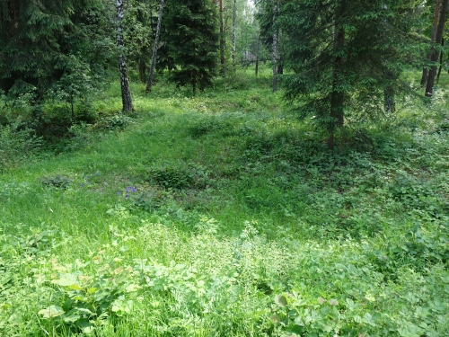
Together with 4 Polish tourists and guide Kinga I walked further into the forest. Thousands of flint mines lie beneath the ground here. They can be recognized by small ‘dents’ in the landscape, a bit similar to bomb craters. Next to these pits are ‘hills’, the slag heaps. Everything is now overgrown with grass and trees so it is not very visible up-and-close.

There were 4 types of mining executed here, but they all had in common that they had to reach up to 10 meters deep to reach the veins with flint. This location has 2 veins approximately 1 meter above each other. They were formed when there was a large lake here: trenches made by animals in the bottom of the lake were filled with deposits, which eventually solidified into the rock hard flint.
As visitors, we were allowed to go underground at the 3rd mine. We descended via an iron spiral staircase, after which we found ourselves in a cool corridor. Also in prehistoric times the miners connected the various smaller mines with corridors. However, the ones of today have been made with 20th century visitors in mind so they don't bump their head.
Flint is still abundantly present in these limestone walls. It was extracted here in an almost industrial way: the flint was brought to the surface and worked there into hammers and chisels. Flint tools that were made here have been found up to 600km away.
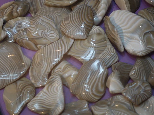
Once back at the site entrance there still was the permanent exhibition to visit. It is not immediately obvious where it is (it is in the building marked ‘Tourist Information’), so I asked the guide to show me the way. She subsequently gave me a private tour inside - all accompanying texts are in Polish and she was sorry that I could not read them. Different types of flint from all over the world are shown here. Most of it is characteristically black, whereas the flint of Krzemionki is of the striped variety which only occurs in this region. In polished form they make for nice souvenirs or even jewellery.
Els - 30 June 2019
Comments
Solivagant 3 July 2019
PS. This academic article from 2016 has aerial photos of the Borownia site including Laser Scans. Nothing much for the ordinary visitor to see -
https://pdfs.semanticscholar.org/8e3f/a51da12ab5521305086fc808181885167264.pdf?_ga=2.67288657.1197636829.1562176982-1227947630.1562176982
Solivagant 3 July 2019
This "News" (in Polish) on the Krzemionki Web site shows photos of the 2017 dig at Borownia -
http://krzemionki.pl/aktualnosci/archeologiczne-badania-wykopaliskowe-prehistorycznej-kopalni-krzemienia-borownia-w-rudzie-koscielnej/#
translation for a couple of sections -
"Until July 2017, archaeological works carried out in the "Borownia" area had the character of surface surveys; geophysical and other technical methods were also carried out, among them airborne laser scanning (ALS)."
and
"The archaeological excavations undertaken in July 2017 resulted mainly from this year's decision on the notification of this object along with the "Krzemionki Opatowskie" and "Korycizna" mines to the UNESCO World Heritage List. Initially, only the mine in Krzemionki was to be registered on the list of world heritage. The consultations carried out in recent months by an international group of specialists in the field of the World Heritage List indicated that the notification of the mine itself in Krzemionki, in view of the fact that in 2000, the Neolithic Flint Mine in Spiennes (Belgium) was entered into the World Heritage List, is associated with the risk that the application of Krzemionki will be rejected. In the opinion of Polish and foreign specialists, the chance to enter Krzemionki will increase significantly" . As I suggested in my first comment!
The 2017 dig of the type shown in those photos will all have been backfilled after documentation and removal of artefacts - it is clearly situated in a forest among many trees - there may be some visible undulations etc in the area but nothing really to see?? Really rather similar to much of the surface area at Spiennes and also at Krzemionki itself, away from the Tourist trail.
Els Slots 3 July 2019
Hi 'user' - can you give us a bit more information about how the other 3 sites can be visited? Or do we just look at them from a distance?
user 3 July 2019
All 4 components can be visited. The mines in Krzemionki are open to visitors in the form of a tourist route, Borownia and Korycizna have the best-preserved mining landscape from the Stone and Bronze Age, and Gawroniec has underground objects associated with settlement and the production of flint tools.
Els Slots 30 June 2019
I did research it a bit beforehand, but I believe the other 3 cannot be visited. The settlement
site of Gawroniec sounds the most interesting, polished axes have been found here. I think I read somewhere that it has been covered up since.
Solivagant 30 June 2019
Did you gain any sense of what the other 3 locations are like? Is there anything to see? A
are any worth visiting? Were they even mentioned? The Google Map satellite view seems to show nothing above ground at all at the coordinates. Perhaps just like most of the Pile dwelling sites - archaeological sites which have been back-covered? A cynical view might be that they have only been included in order to provide something different from Spiennes!