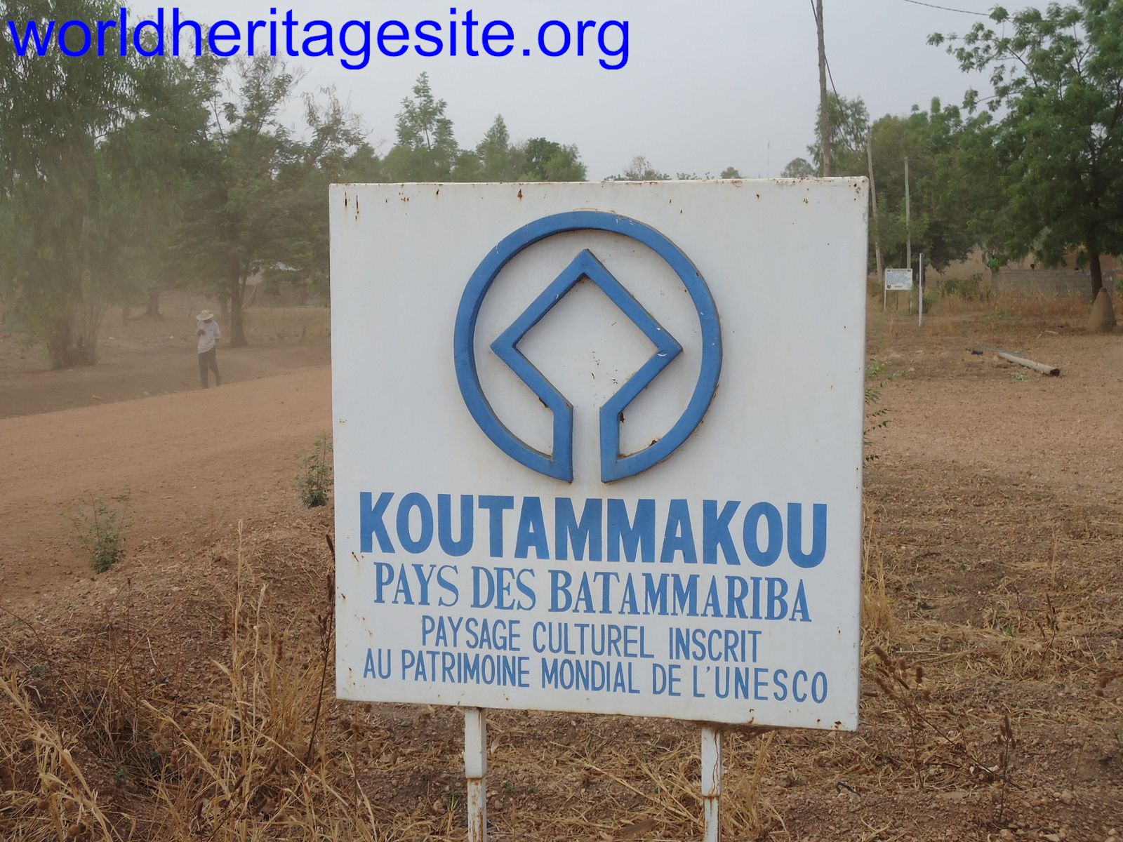
Koutammakou
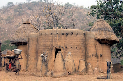
Koutammakou, the land of the Batammariba, represents a traditional way of settlement known for the architecture of mud “takienta” tower houses.
Most of these buildings have two stories, and either flat or conical thatched roofs. They combine domestic functions with space for animals and granaries. Koutammakou also is a living cultural landscape where the agricultural society lives in harmony with the surrounding nature. This is expressed in sacred forests, rocks and intangible elements.
Community Perspective: a highlight of a trip to Togo, where a local guide with appropriate knowledge, contacts and language is absolutely essential. Solivagant visited villages in both Togo and Benin, the latter proving "a more fruitful area for exploration and interaction with the Battamariba".


Map of Koutammakou
Community Reviews
Christravelblog

Koutammakou, the land of the Batammariba, is currently the only UNESCO World Heritage Site in Togo. If you are interested in local culture and ethnicities, visiting Koutammakou should be on your Togo travel itinerary. The site can be easily reached as a day trip from Kara via Kandé, which is a 2.5-hour drive one way. This day trip was the highlight of my Togo road trip itinerary. I left Kara at around 8:30 AM and arrived at the entrance at 10:00 AM. There is a small fee that must be paid, and you must be accompanied by a local guide. It is important to respect the local Tamberma people and their traditional way of life.
Tata or Takienta houses are mud and straw castles with a ground floor for livestock, a kitchen on the "middle" floor, and sleeping quarters on the roof. With one entrance and Voodoo deities protecting it, the homes are easily defendable. The Batammariba people live in small villages grouped around a water source and fertile land, and they maintain their long-standing traditions while living in harmony with nature.
For me, this was the highlight in Togo.I really enjoyed my visit and see the locals. When I left the were just brewing their local "beer"which I had the option to taste. If you have a overreacting stomach I would refrain from trying.
It's a site quite far away and maybe on many WHS visitors "to see list". The new Togo TWHS list is also interesting. Will add these reviews as well.
Read more from Christravelblog here.
Kelly Jones
I lived in this area for two years as a Peace Corps Volunteer. It is truly an amazing people and an amazing cultural experience. The architecture is phenomenal and a prideful part of their lives. There is not a lot of infrastructure develped for tourists. So visitors need to be aware of that and accomodating. Organization for toursits can also be confusing as there is currently no good set up of finding a guide, renting a car, lodging, etc. Try and make sure who you are paying is really a local person and be respectful of the community. There have been some negative effects of tourism already. Children chase cars and people beg for gifts. Don't give out gifts. But always ask before taking photographs and pay them if they ask for money or give them some other small gift.
Solivagant

Anyone interested in Ethnology, Architecture, Cultural landscapes or African culture generally should try to reach this site. It consists of an area of country in NE Togo and NW Benin which is inhabited by the Battamariba people (who were called Tamberma by the colonial administration – we were told this meant “Good Builders”). Their “fortified” mud-brick houses called “Tata” (or Takienta”) are remarkable both visibly and as an introduction to their entire way of life and to their (animist) beliefs (photo). Walking the hilly savannah between the “villages”, seeing the daily life and agriculture and going inside a few houses is a fine travel experience which we did in Jan 2007, covering villages in both Togo and Benin.
We reached the Togolese inscribed area of “Koutammakou” via a dirt road NE from Kande before crossing into Benin south of Boukombe. The areas we saw in both countries didn't seem to be as significantly on the international travel route as the Dogon country in Mali then was. However, visits to those Tata near to the road, which were all we saw in Togo, were somewhat more “touristy” than I had hoped, with displays of handicrafts for sale and calls for “cadeaux” from hordes of children. Across the Benin border the area (which was not then included in the UNESCO site) proved in our experience, more fruitful for exploration and interaction with the Battamariba as we were able to partake in a full day's walk reasonably well away from the roads. Our (Togolese) guide claimed that there were differences in culture between those on either side of the border but we were never able to obtain a clear explanation of these though it does appear that different terms for the peoples are in use in each country as per this article.
You will have to come to terms “morally” with the fact that your visit to these people will not be “impactless” (both good and bad). A local guide with appropriate knowledge, contacts and language is absolutely essential but I can give no advice on how best to choose one who will do his best to ensure as little “exploitation” as possible – guides of unknown (and no doubt variable) quality can certainly be obtained locally. We travelled with an apparently reputable Togolese travel company (TransAfrica) and felt that the visits to the houses were conducted responsibly with a reasonable recompense to the families which didn’t distort the local economy too much and with a sensitivity to the Battamariba as human beings.
In Benin the "tourist centre" for the "Tata Somba" area is the medium sized (60k pop in 2002) town of Boukoumbe and we stayed a few kms away NW at the village of Kossoucoingou where our guide came from. Entrance to the Togolese “park” was only around 2 euro (I don't know the details for Benin but I don't remember the same sort of "controlled entry" to a "Park" area). At the entrance hut I obtained a fine 36 page colour booklet (in French) produced by CRATerre (ISBN 2-906901-39-3) with explanations of Battamariba history, religion, social organisation, farming practices and, above all the layout, construction and “meaning” of the multi-roomed houses. However good your guide might be there is just so much to take in and you will need a reference for later - but I got the last one!!
PS. This entire booklet was available for download when i first wrote this review. That no longer seems to be the case but Craterre have another booklet on the Battamariba architecture titled "Architecture & paysage Bètammaribè. Villefontaine : CRAterre-EAG. 36 p. ISBN 2-906901-31-8" available to view here .
PS. In Sept 2023 I adjusted this Jan 2007 review to reflect the addition at the 2023 WHC of a Beninois component to create a single transnational WHS by adding our experiences of visiting that additional area as at the time. I have NOT tried to update the review in any other way, though the site will undoubtedly have undergone much change across the intervening 16+ years. It does seem worth commenting, however, on the absolute appropriateness of the "addition". The originally inscribed Togolese section was a truncated "nonsense" and it is good that Benin and Togo have been able to work together to create a coherent single WHS. It might be worth highlighting that the resultant site is in fact primarily in Benin and the Togolese element is now very much the "junior" one in size - 240k to 31k ha respectively (and Benin even "discovered" that the Togolese section was significantly smaller than had previously been claimed!!). This means of course that the addition includes large areas which we never visited - these include the large regional centre of Natitingou and its hinterland way beyond what is normally portrayed as the "Battammariba heartland" around Boukoumbe. The excellent, and lavishly illustrated, 2023 Nomination file (it is interesting to compare it with the "utility version" of 2004 from Togo as an indication of the way in which the "rules" of the "Nomination game" have changed across c20 years ) is, IMO, essential reading for understanding the site and its cultural/tribal complexities and is in many ways superior to the booklet I previously recommended.
Back in 2007 I commented on how the Togolese and Beninois "sides" seemed to us to be exactly the same. The creation of a single cultural WHS highlights the reality of the "unnatural" frontiers created during the "Scramble for Africa" in the late 19th C. This "Old German Map of Togo" shows the Frontier agreed between France and Germany between 1883 and 1897. The WHS is situated top right where the previously northerly direction of the boundary turns diagonally NW at 10° N in what is at first a rather straight line. If you zoom in on it you will see that the word "Tamberma" is written across both sides (see my 1st para above). As France and Germany extended their interests inland from their respective concessions on the coast at Porto Novo (France in 1883) and Agbodrafo (Germany in 1884) they reached agreements on the various points to be used as the boundary. With these words in July 1897 the division of the Tamberma country across 2 colonial states was agreed - "It shall then run down the thalweg of the Kara River for 5 kilometers and from that point shall run northward in a straight line to Lat. 10° N., but in any case Semere shall continue to belong to France. From there, the frontier shall run directly to a point equidistant between Dje and Gandou, leaving Dje to France and Gandou to Germany, and shall extend to Lat. 11° N. following a line parallel to the road from Sansanne-Mango to Pama at a distance of 30 kilometers from the road"!! (Section specifically relevant to the current WHS is in bold). Source "International boundary Study Benin (Dahomey) – Togo Boundary")
Community Rating
Site Info
- Full Name
- Koutammakou, the Land of the Batammariba
- Unesco ID
- 1140
- Country
- Benin Togo
- Inscribed
- 2004
- Type
- Cultural
- Criteria
-
5 6
- Categories
- Cultural Landscape - Continuing
- Link
- By ID
Site History
2023 Extended
To include area in Benin
2023 Advisory Body overruled
ICOMOS advised Referral for Extension
2020 Revision
Includes former TWHS Habitats fortifiés: Tata Somba (1987-1996)
2004 Inscribed
Site Links
Unesco Website
Official Website
Related
Connections
The site has 23 connections
Art and Architecture
Constructions
Geography
Human Activity
Timeline
Trivia
Visiting conditions
WHS on Other Lists
World Heritage Process
Visitors
33 Community Members have visited.
The Plaque
 (photo by Jarek)
 (photo by Bram de Bruin)