Blog WHS Visits
WHS #605: Swiss Alps
When I was a child, we always went on holiday to the Allgäu Alps. Living near the German border, my parents only spoke German as a foreign language and felt the most comfortable in German-speaking countries. We went there so often that we even were designated by the local tourist organization with a special pin celebrating 10 (or 15?) visits. So I have seen my fair share of Alpine landscape and know the omnipresent sound of cowbells. Although I must confess that when I got older I skipped all the hiking and my parents often left me at the hotel with a book to read.
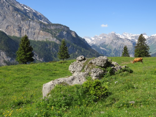 |
| Starting the hike |
This background might be the reason that I left it so long to visit the Swiss Alps WHS. But also the site’s inaccessibility played a part: the WHS originally encompassed only the Jungfrau-Aletsch area, which is quite costly to visit and doesn’t lend itself for a short weekend break. Since 2007 however, the core zone has been extended across a wider area in the Bernese Alps. Additional access points to the east and west have come into play.
I choose Kandersteg as my base, a town some 2.5 hours from Zürich Airport. From here a cable car takes you for 18SFR to the Oeschinen Lake, which lies already within the inscribed area. At a gloriously sunny Friday in late June I arrived at the top cable car station around 10 am. From that point a number of hikes are signposted, of which I took the ‘Heuberg Panoramaweg’. Most people will just walk half an hour down to the lake, especially the groups, but this route follows a path on a ridge somewhere mid-level up the mountains. It has great views on both the lake and the massif of High Alps. The highest top you can see from here is the Bluemlisalp with a height of 3,661m.
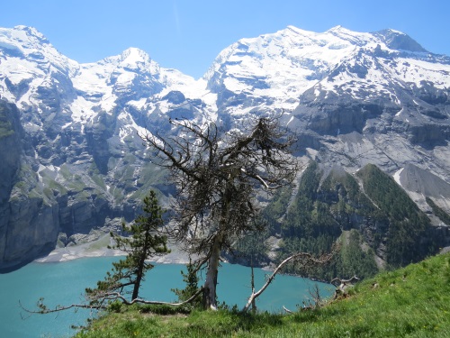 |
| Oeschinen Lake and High Alps |
The route steadily goes uphill for the first 1 to 1.5 hours. A few times I had to cross little streams coming down from the mountains, once even I got my socks totally wet. But there are many places to rest, and I dried my socks for a while in the sun. There were some 10 other hikers active on this route this morning, and we kept on seeing and passing each other all day. The trail takes 3 to 4 hours to complete, but most took it slowly and sat down often to enjoy the views. At Underbärgli (a spot with a few farms near the far side of the lake) there’s a nice little café where I had the soup of the day for lunch.
It’s all downhill from there. The path stays on the same side of the lake, and now has fine views of its pebbled beach and enclosed setting. The Oeschienen Lake is a 56m deep glacial lake and one of the larger Alpine lakes. It is fed by the glaciers of the surrounding peaks. It is possible to walk back to Kandersteg from here instead of taking the cable car back – I did so and it took another hour. You won’t see anything though that you haven’t seen earlier in the day and it takes some additional concentration as it is steeply downhill on a terrain of loose stones.
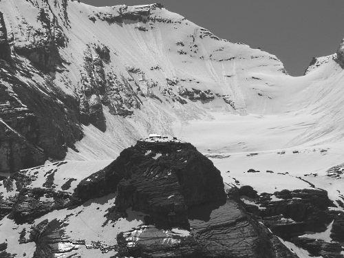 |
| Fründenhütte amidst the snow-clad mountains |
Remarkable about this WHS sublocation is that they haven’t pimped it. It is what it is: an Alpine mountain landscape with a lake, with hiking paths and two or three places to have something to eat or drink. No adventure sports, no interpretative trail, no visitor center. Kandersteg itself has been a tourist destination since the late 19th century. Nowadays it's a somewhat oldfashioned town, still popular with elderly British.
Els - 25 June 2016
Comments
clyde 27 June 2016
Interesting review. Since the Top of Europe was an extraordinary experience for me and I was very lucky with the weather, next time I'll be in Switzerland I'll visit this other natural aspect of this WHS and save some money.