Els Slots
Whs #774: Sierra De San Francisco
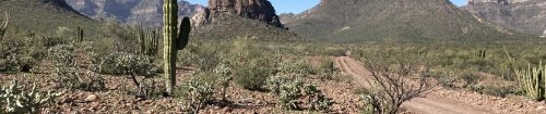
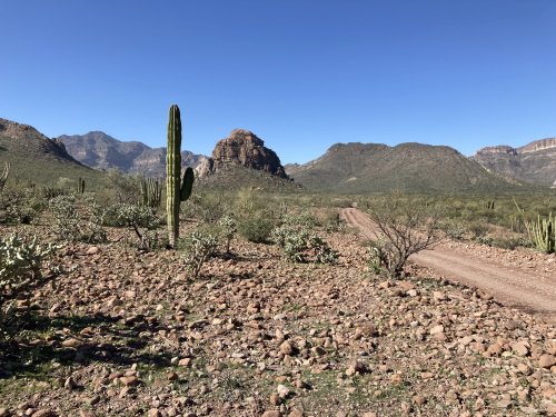
The Rock Paintings of the Sierra de San Francisco have hardly been reviewed on this website so far, so let’s start with the basics. The included area is large (it’s even in the Top 20 of largest cultural WHS ) and stretches out north of Mexico’s Highway #1 in Baja California Sur between San Ignacio and El Porvenir. It holds several hundred small groups of rock paintings and rock carvings. The area is remote and difficult to access: for a day trip you have the choice between Ratón (via San Francisco de la Sierra: needs 4WD, an only short climb up a staircase, small group of paintings) and Palmarito (via Santa Martha: car with good clearance needed, requires a 1.5-hour hike, rock face with abundant paintings). If you go by yourself, you need to report to the INAH office in San Ignacio beforehand to pay the entrance fee and they will let the local caretaker know that you’re coming and he will lead you to the site of the rock art. Multi-day trips that are offered by specialized outfitters use mules to trek to the even more isolated cave paintings, which are also said to be the best.
I choose Palmarito as the location for my visit. As I had only a rental car with fairly low clearance, I played it safe by hiring a 4WD with guide/driver to take me out there. It was arranged by the place where I was staying (Ignacio Springs B&B in San Ignacio) and cost 1,500 pesos (67 EUR) per person. You could also ask at Rancho Grande restaurant, as they were the people who eventually drove me and two other guests of the B&B. I met them at the town of Bonfil by Highway #1, that’s where the unpaved track inland to Santa Martha starts. I hadn’t been able to find the mountain community of Santa Martha on any of the maps I had on my phone (Maps.me, Google Maps, Waze), the official map of the WHS and the one of the INAH website are the best ones of the area.
It's a 40km drive to Santa Martha. The road is mostly good, but there are some rough patches and crossings of river beds. It felt like driving in one of those classic Western movies, with a stagecoach raid about to happen at every corner. About 60 people live in Santa Martha, and they even have school. Most people seem to live off goat farming and we got to taste some of their delicious fresh cheese. There’s no cell phone reception here or along the road. Our local guide was already waiting by the roadside and we took him along to the starting point of the hike – the road for this final 5 km is in very bad condition and needs a 4WD.
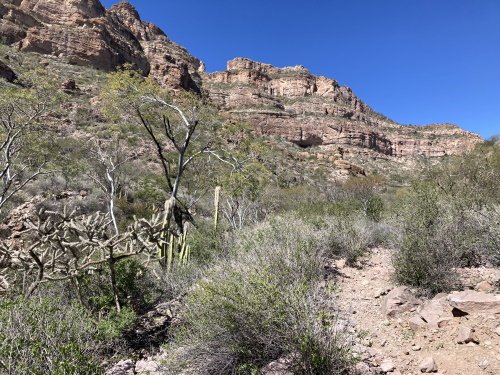
The trail towards the rock shelter where the paintings are is fairly flat and easy for the first hour. You walk among a great variety of cactuses and medicinal plants, which contribute to the great scenery of the Sierra de San Francisco together with its many mountains. The rock and some of the paintings can already be seen from the trail: the larger paintings depict humans, it looks like they are waving to the people passing by. The final half-hour comprises the climb up to the rock shelter – the trail uses hairpin bends here to soften the steepness. It wasn’t too difficult going up, but going down is more tricky as there are a lot of loose stones. It’s best to wear proper hiking boots and/or use trekking poles.
The rock is protected by a fence, to which the local guide had the keys. You can then enter the wooden viewing platform that has been built directly underneath the paintings. The rock face is about 30m wide, and almost fully covered in paintings in red and black. Animals that are depicted include a tortoise, a puma, and deer. There isn’t any interpretation on-site (such as an information panel) and the guide also does not go much beyond pointing out the more remarkable paintings.
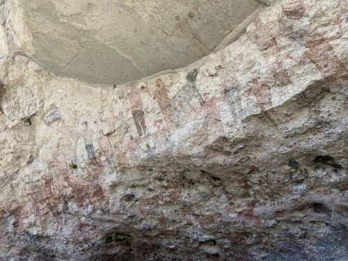
The paintings artistically aren’t that spectacular, nor are they very old. In the AB evaluation, they were dated from 1100 BC to AD 1300, while Wiki now states “A growing body of radiocarbon dates relating to the paintings has suggested ages from as early as 5500 BCE”. As said in the introduction, the more remote clusters that require multi-day trekking are said the be the finest. However, it is certainly worth visiting Palmarito as well for its great scenery that you will be able to enjoy along the road up there and during the hike.
Comments
4 comments