
Els Slots
Minor Boundary Modifications
Minor Boundary Modifications are a ‘thing’: over the past 18 years or so (I see them first appearing in 2005), over 120 of these modifications have been approved. They take up a lot of time from the State Parties and ICOMOS/IUCN in clarification but always pass through without discussion at WHC meetings so their contents stay a bit hidden.
We’ve had them as a Connection for a long time, but it was just a list without explanations – so it did not fit the requirement that we can actually learn something from it. I decided to refocus it, by only mentioning changes made to the core zones (about 60% of the modifications regard buffer zone changes or new buffer zones). The new definition will be: “Sites where a "Minor modification” has been approved after the year of inscription. Includes only modifications to the core zone that add or remove a named element.”
The difference between a minor boundary modification and an extension
There are actually three mechanisms within the WH process that deal with site boundaries. There is an ongoing ‘project’ of the WHC called ‘Clarification of boundaries’ which requests proper maps and coordinates for WHS which do not have them yet. Then there is the minor modification: “one which does not have a significant impact on the extent of the property nor affects its Outstanding Universal Value”. If the modification proposed is deemed too significant, the procedure for new nominations will apply (and you get what we call an “Extension”).
Refocusing on the core zones
I started from the 113 sites in the old connection and checked them all on the UNESCO website what the change involved. I deleted the changes to buffer zones, and also those changes that were mere cartographic errors and did not lead to a named component being added or deleted. For the ones remaining, I added a rationale. Here’s the updated list .
This list may not be complete – I have not gone through the decisions year by year. I only did so for the past 2022/2023 session, which yielded a few more notable entries including huge extensions to the French Austral Lands and Taï National Park, and the addition of a few more monuments in Lima.
Why were these boundary changes needed?
Countries submit Minor Boundary Modifications for a variety of reasons. The following types can be distinguished:
- New archeological discoveries: Choirokoitia and Jelling were extended because new findings were made just outside of the original core zone, while at Stonehenge the Fyfield Down site was revalued due to scientific work in 2000 (so it was moved from buffer to core zone).
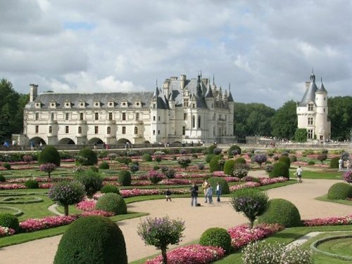
- Result of Clarification of boundaries: the 'Clarification of boundaries' process often brings inconsistencies to light, in the case of the Loire Valley for example the Estate of Chenonceau was mentioned in the text but not part of the designated area on the map.
- Rationalizing: sometimes an inscribed area just proves to be illogical and it gets corrected. At Durham, the part between the Castle and the Cathedral was added to show the continuity between the two. For Manu NP, the NP boundaries were followed which was not the case at inscription.
- Redrawing National Park borders: natural WHS often have their boundaries correspond with the boundaries of national parks, as it makes for easier management. If the national park boundaries change, so should those of the WHS (e.g. Donana).
- Include something that was left out of the inscription on purpose: at Kakadu, the Koongarra Project Area was left out originally due to uranium deposits found.
- Removing parts that “cannot be saved”: the more tragic side of the previous one, where a part of the WHS is just given up. This was the case at Selous, to allow uranium mining.
- Local circumstances: the funniest is Giant’s Causeway, where the coastal border has been moved 5m inland due to coastal erosion – otherwise the coastal cliffs (part of the OUV) would not be in the core zone anymore in a few years!
What were the side effects?
Although such modifications may not have a significant impact on the extent of the property, some have fairly substantial consequences:
- Becomes a serial site: Lena Pillars, Lima.
- Or loses locations: Rammelsberg and Goslar, Westminster.
- Significant increase in size: 14% Bosra, 20% Naples, 53% Taï National Park, 147% French Austral Lands.
- Significant decrease in size: 30% Willandra Lakes.
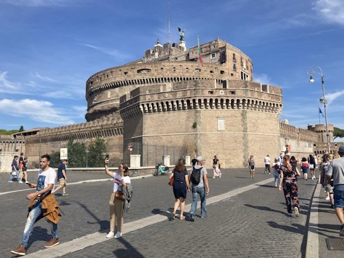
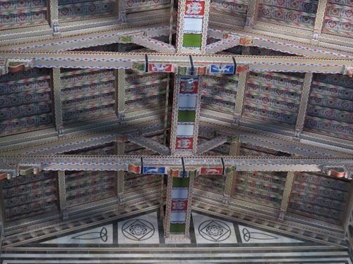
Pictured with this post are three notable sights that have been added via a Minor Boundary Modification: from top to bottom, Castel Sant'Angelo in Rome, San Miniato al Monte in Florence and the Chenonceau Castle in the Loire Valley.
Comments
9 comments