Pyrénées - Mont Perdu
Pyrénées - Mont Perdu is a visually dramatic mountain landscape shaped by a pastoral transhumance system.
The protected area centered around the peak of Mont Perdu lies at the tectonic collision point of the Iberian and West European plates. The calcareous massif has several important geological, scenic and botanical values. A centuries-old transhumant system of grazing also continues within the area with frequent movement of herds across the French-Spanish border.
Community Perspective: On the Spanish side, the Ordesa Valley is the best suited for a visit and offers good hiking. The French side offers the Cirque de Gavarnie (you can even ski here!).
")

Map of Pyrénées - Mont Perdu
Community Reviews
Tsunami
Japan / USA / Europe - 01-Jan-23 -

This report has to do with the French side. The main place to visit is Gavarnie, the site of one of the three "Cirques" in the area.
In visiting a WHS I don't think I have experienced so many "twists" as I did with this Pyrenees WHS.
When I was planning a trip to finish mainland France in winter 2019-2020 (just before the pandemic), I realized that it was better to visit all national / nature park-related WHS in France / Andorra in summer, not only because you can see more, but because public transportation is more frequent. So I postponed my visit to this Pyrenees WHS until some summer later.
Then, when I was planning such trip to visit this and other French / Andorra WHSs in summer 2022, I came across the following statement on the top page of the Gavarnie-Gedre Ski Resort: "In winter, near the Cirque de Gavarnie, discover a ski area ... in the heart of a UNESCO World Heritage Site!"
Pardon??? In the heart? You mean in the core zone? It can't be true! (I had in my mind the Bansko Ski Resort at the Pirin National Park WHS in Bulgaria where the ski area lies within the buffer zone surrounded the the core zone.) Upon my careful inspection of the WHS map, however, I concluded that at least one of the ski lift stations was within the core zone. I was fascinated by the idea of skiing in the core zone of a WHS. OK, I'll go! So I postponed my visit to this WHS once again until some winter later.
Such winter was this winter. I booked a non-cancellable open jaw trip, 2 weeks apart, to France to visit the Pyrenees WHS and several WHSs in Northern Spain. Then, as my trip approached in mid-December 2022, the Gavarnie Ski Resort announced that, due to little snow, the opening of the resort was postponed until further notice! It was too late for me to cancel this two week trip (as I aslo had 2 theater tickets on the first day in Toulouse and the last day in Paris), so I went ahead and ended up waiting for the ski resort to open in Toulouse and Lourdes and canceled the whole trip to northern Spain. (The lack of snow turned out to be a Europe-wide problem in winter 2022-23. But this ski resort eventually opened on 21/01/2023.)
Then came the biggest twist:
While staying in Lourdes over Christmas, I started wondering why the Cirque de Gavarnie in photos looked so familiar to me and suddenly realized that it was actually the Lake Louise with the wall of cliffs in the background in the Canadian Rockies that looked so much like the Cirque de Gavarnie. The Lake Louise, especially when seen from the pistes of the Lake Louise Ski Resort, was unforgettably beautiful!
Wait a minute, I said. I have skied at a core zone of a WHS before! namely the Lake Louise Ski Resort at the Banff National Park within the Canadian Rocky Mountain Parks WHS. Besides being a part of a WHS, Gavarnie-Gedra is just a minor ski resort. So I suddenly lost the whole reason to go skiing at the Gavarnie-Gedre!
Well, I wasn't just going skiing there and tick this WHS. I was also planning to hike/snowshoe/Nordic ski to the Cirque de Gavarnie. So, from Lourdes I took a direct bus all the way to the village of Gavarnie one day and spent 6 hours in the area.
My first stop was the tourist info office at Gavarnie. The first thing I found out was that there was so little snow that there was no need for snowshoes or Nordic skis. They recommended hiking a loop that approached the Cirque. They also said that you could walk on the path along the stream toward the "Hôtel du Cirque et de la Cascade," but due to the possibility of avalanche not of snow but of rocks, they did not recommend the path.
My second stop was Mairie / City Hall of Gavarnie that dabbles as the Office of the Pyrenees National Park, which has a little museum / exhibition space. Outside of it was a UNESCO plaque (lower left photo).
My third stop was the église paroissiale Saint-Jean-Baptiste, which is one of the 78 components of the Routes of Santiago de Compostela in France WHS (lower right photo).
The loop recommended by the tourist office starts right behind this church. Unlike the path along the stream that is designed also for cars, this loop is a hiking trail, but it was not very well marked, and when the loop crossed the path at the nearest point to the Cirque, I decided to forgo this loop and jump on the path. The truth was that I seemed to be the only one walking on the loop, and several dozen other tourists who didn't bother stopping at the tourist office were walking on this path despite the risk of falling rocks.
I repeat: there was little snow in the Gavarnie area when I was there in late December. This meant that people were walking not only to the "Hôtel du Cirque et de la Cascade," but also all the way to the Cascada de Gavarnie (lower middle photo), the tallest waterfall in mainland France at 422 m, although only a little water was falling. This hike from the hotel to the waterfall took another hour or so, and right below the waterfall you need to climb up on the steep slope covered by the rocks that have fallen before.
On the way back I just walked on the path along the stream straight back to the village of Gavarnie. This path generally offered better views of the Cirque (upper photo) than half the loop I walked on earlier.
As far as the cultural part of this WHS goes, I was not able to see any signs of pastoral life even without snow.
All in all, even though I did not accomplish my initial aim of skiing at this Pyrenees WHS, hiking all the way to the Cascada at the Cirque was more than what I expected. I wished I had not taken the hiking loop at all, as all the activities described above took up all 6 hours of my time at Gavarnie, and I did not even have time for lunch that day.
And who knows? There may be even more twists coming! If I discover that the Lake Louise Ski Resort is indeed excluded from the core zone of the Canadian Rocky Mountain Parks WHS, I would have to go back to Gavarnie for skiing!
Read more from Tsunami here.
Mahuhe

Unlike the previous reviewers, I visited the French part of the World Heritage Site, to be more precise the Cirque de Gavarnie. The Cirque is a deep, amphitheatre like valley formed by glaciers, with steep, very high cliffs (the mountains rise up to 1500 meters above the valley floor). It is also home to one of the highest waterfalls in Europe.
I visited the Cirque in July 2020 on a day trip. I stayed overnight in Lourdes and drove by car to the village of Gavarnie (takes about an hour). You are not allowed to enter the village center by car, but there is paid parking near it. I think, the earlier you arrive, the better. In high season, there is the real possibility of traffic jam on the small roads leading to the village. And when I arrived around 10 a.m. the parking was already quite full, too.
Even from the village - provided there are no clouds - you have spectacular views of the Cirque. After an easy hike on dirt roads (duration about one hour), I reached the restaurant at the entrance of the Cirque. From there, you can take several trails. I decided against the path to the waterfall and instead crossed the river and walked past sheep to a snow field at the foot of the rock walls. Much more challenging routes (including through the cliffs up to the Breche de Roland pass) are also available for the more ambitious hikers. But I was already very satisfied with my little hike at the bottom of the valley.
A visit is worthwhile in any case. The landscape is for sure very spectacular (especially compared to the other Pyrenees WHS Madriu-Perafita-Claror Valley in Andorra). However, the Cirque is a major tourist attraction in summer and you won't be the only visitor...
Els Slots

Like all other reviewers until now, I approached this WHS from the Spanish side through Ordesa National Park. The town of Torla is an easy and comfortable access point. At 7.30 a.m. I took one of the first shuttle buses of the day into the park. There were 10 other hikers aboard, certainly not a lot for a Saturday in July. The Mont Perdu WHS apparently sees more than 2 million visitors yearly (Spanish and French totals combined), which is hard to believe given its low-key appearance.
I had been in doubt about which hike to do: the longer trail along the ridge (Senda de los Cazadores), or the shorter one through the valley. My experiences from a few days before in the Madriu Valley made me choose the shorter trail: I am not fond of climbing a lot or getting soaking wet due to a surprise rain shower. The valley hike is still 17km long and takes 5 to 6 hours. Both trails end at the Cola de Caballo waterfall.
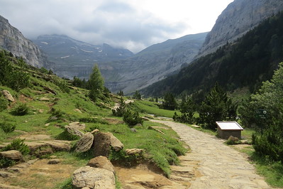
The valley hike has three distinct parts. It starts with an uphill slug through a forest, not the most interesting stretch and it took me 1.5 hours. Things brighten up a lot when you’re in the open at last: the path next to the river is lovely. I especially liked all the flowers in bloom, their colours and their smell. After a series of steep waterfalls, you’ll reach the alpine plateau with views of Mont Perdu. It gets much cooler here. A herd of cows was lazing around near the finishing point. In all, a fine scenic walk but a pity that you have to walk the same route back.
The next day I had some hours to kill before my flight home, and I decided to visit another part of Ordesa National Park. The Añisco Canyon lies beyond the village of Fanlo, about 40 minutes to the east of Torla. It is not signposted very well so you’ll have to look for directions beforehand (my car navigation also wasn’t helpful). Central point is the Ermita de San Úrbez, an 8th-century hermit’s cave and pilgrimage destination. I approached it from the upper car park, which leaves you with 2x 15 minutes of hiking time to the site itself.
The lower car park can only be reached from the other side of the canyon. It lies next to the bridge to the hermit’s cave. There’s a fine 1-hour trail that leads you along various viewpoints into the canyon. As noted in our Connections section, the Ermita de San Úrbez also is the home of another WHS: a piece of Rock Art of the Mediterranean Basin is also here. But where is it? I vaguely remember having read a description that it can be found just outside the cave, however, there’s no sign or any other indication. What a weird WHS this Mediterranean Rock Art is, I think it proves a country cannot maintain 727 separate locations!
A bit disillusioned I walk back to the parking lot. Suddenly I see a huge bird oozing through the canyon. There’s no doubt – it must be the bearded vulture with its enormous wingspan and white head. I had seen some others the day before but from a large distance, so it wasn’t clear if these were bearded or “regular” (griffon) vultures. Seeing one passing by so closely was a magnificent finale to my visit to Ordesa NP.
Read more from Els Slots here.
Hubert

In May 2014, we spent three days in the National Park Ordesa y Monte Perdido, the Spanish part of this transnational WHS. Beside the Monte Perdido summit the inscribed area comprises four deep valleys that are accessible to hikers: Ordesa, Añisclo, Escuain, and Pineta. We went for two hiking tours in the Valle de Ordesa and one in the Canyon de Añisclo .
There are hardly any roads in the National Park, one of the few is the access road (HU-631) to the Añisclo valley from Escalona. The ride on this very narrow and winding road was exciting and offered wonderful views into the deep gorge. After 12 km we reached the parking lot at the Ermita de San Urbez. The Añisclo valley is a very narrow canyon between steep, almost vertical cliffs. The hiking trail runs continuously uphill along the Bellos river and through forest and lush vegetation. It is easy to walk, there are only a few steep sections. After about 3.5 hours we reached the Fonblanca waterfall and returned on the same route to the parking lot. We enjoyed very much our hike through this striking landscape, but the Valle de Ordesa was even more impressive.
The starting point for tours in the Valle de Ordesa is the picturesque village of Torla. From there it is only 5 kilometres to the parking lot Pradera de Ordesa (at 1350 metres altitude) where several hiking trails start. Ordesa is very popular with hikers and climbers, the parking lot is huge and in summer the access is restricted for private vehicles, you have to take the shuttle bus from Torla. However, when we arrived at 8 am, there were only a few other cars, probably because of the heavy rainfall the days before and the rather cold temperature of only 5 degrees in the morning. But after the morning mist has lifted, it was a beautiful warm day with clear blue sky.
As described by Clyde in his review below, there are hiking trails of different grades and at various altitudes. Our first hiking tour started with an exhausting steep climb up to an altitude of 2000 metre (650 metres vertical difference). Then we walked on the Faja de Pelay slightly downhill to the end of the valley, the Circo de Soaso. We enjoyed magnificent views of the rock formations on the opposite side of the valley and the snow-covered peak of the Monte Perdido. The Circo de Soaso is a picturesque spot: a green meadow with a babbling stream and a waterfall, surrounded by steep rock walls. And to make it perfectly picturesque, there were also grazing cattle. The trail back to the Pradera leads through deciduous woodland and past spectacular cascades (photo: Estrecho waterfall). There are signposts to several viewing points, all are worthwhile. The next day, we hiked along the rock wall on the north side of the Ordesa Valley (at a maximum altitude of 1800 metres): the Faja Racon, Circo de Cotatuero, and the Faja Canarellos.
I agree with Clyde, that the easy trail in the valley is the most scenic hike, and the trail is suitable also for less experienced hikers. We enjoyed the three days in this scenic mountain landscape. The deep canyons and steep rock formations of the Monte Perdido massif are outstanding and differ significantly from landscapes in the Alps. We stayed at the lovely Hotel Abetos in Torla, about 300 metres outside the village centre.
Clyde

I visited this WHS in May 2014. I spent 3 days hiking in the Ordesa Valley and I saw Mount Perdu both from strenuous uphill trails like Faja de Pelay at high altitude (not suitable for those who don't have a head for heights) as well as from the easy trail in the valley with lovely cascades, streams and waterfalls. I must say that the most picturesque hike is indeed the easy hike by the Rio Arazas which takes about 7-9 hours if you stop for lunch and to take lots of photos. If you start early at around 7am you will beat the crowds and it really is a very enjoyable trek with rainbows forming early in the morning over the many cascades and waterfalls. The UNESCO plaque is immediately visible after a few minutes of hiking. The Cola de Caballo waterfall is beautiful but you should arrive early there as it's also the place where everyone stops to have lunch. I was surprised that I didn't have to pay an entrance ticket of any sort. All you need there are good hiking shoes and an empty bottle to fill with pure water from the gushing streams. During 3 days of hiking I spotted the rare Lammergeier (Bearded Vulture) amongst different birds of prey and scavengers as well as smaller birds. I was lucky to spot a couple of marmots and 2 big castors near Cola de Caballo and I also enjoyed the varied mountain flora with different kinds of butterflies flying freely around. This is truly a magnificent WHS and one of my favourite transnational mixed WHS in Europe.
Roger
WHS-collectors should do this beautiful hike first: from the eastern end of the Pradera de Ordesa, cross Río Arazas and climb steeply up through the woods on the valley's south side. This hardest part, called "Senda de los Cazadores" (Hunter's Path), in which you ascend 600m, takes an hour. Then it's level or downhill all the way along the high Faja de Pelay path to the 'Circo de Soaso', a rocky balcony whose centrepiece is the Cola de Caballo (Horsetail) waterfall. Return by the easy path along the bottom of the valley, passing through several waterfalls. This circuit takes 7 hours, so bring those picnic sandwiches and mineral water. (Summer 2010)
John booth

The scenery in the Ordesa Valley I found reminiscent of that of Yosemite: high rock walls with numerous waterfalls. I reached the park by travelling by bus from Sabananigo (on the Jaca to Zaragoza rail line) to the attractive village of Torla. After paying the 4.50 euros to enter the Ordesa National Park I boarded the free bus that stopped first at the visitor centre at the entrance to the park, then at the Pradera car park inside the park. This is the starting point for a number of walking tracks around the park. By following the Rio Arazas to the WHS plaque I reached the view of Mount Perdido.
Community Rating
- : Inigo Cia Van Hung Tevity Sibariam Thomas Harold Watson Jezza JLuth KeithBailey
- : Nikolay Marinov Roel Sterken Adolfo Yiqun Jin Persian Globetrotter GeorgeIng61
- : Walter Daniel C-Hazard Ivan Rucek Thibault Magnien Wojciech Fedoruk Cezar Grozavu Jeanne OGrady Stanislaw Warwas M. Huineman de la Cuadra BobSmithseestheworld PabloNorte Kevin247 Wieland Viaje al Patrimonio
- : Els Slots Philipp Peterer Hubert Clyde Xiquinho Silva Mike Dirk-pieter Jean Lecaillon Argo Dwight Zehuan Xiao Tarquinio_Superbo Mahuhe Daniel R-F Philipp Leu Alikander99
- : Ingemar Eriksson Caspar Dechmann Craig Harder Randi Thomsen Ralf Regele HaraldOest Richard Stone CHJLondon
- : Shandos Cleaver Rodinia
- : Solivagant Zoë Sheng
Site Info
- Full Name
- Pyrénées - Mont Perdu
- Unesco ID
- 773
- Country
- France Spain
- Inscribed
- 1997
- Type
- Mixed
- Criteria
-
3 4 5 7 8
- Categories
- Cultural Landscape - Continuing Natural landscape - Mountain
- Link
- By ID
Site History
1999 Extended
To include the upper Valley of Héas (on the French side)
1997 Revision
Partially includes Parc National dOrdesa - Viñamala
1997 Inscribed
Site Links
Unesco Website
Official Website
Connections
The site has 44 connections
Constructions
Ecology
Geography
History
Human Activity
Religion and Belief
Timeline
Trivia
WHS Names
WHS on Other Lists
World Heritage Process
Visitors
190 Community Members have visited.
The Plaque
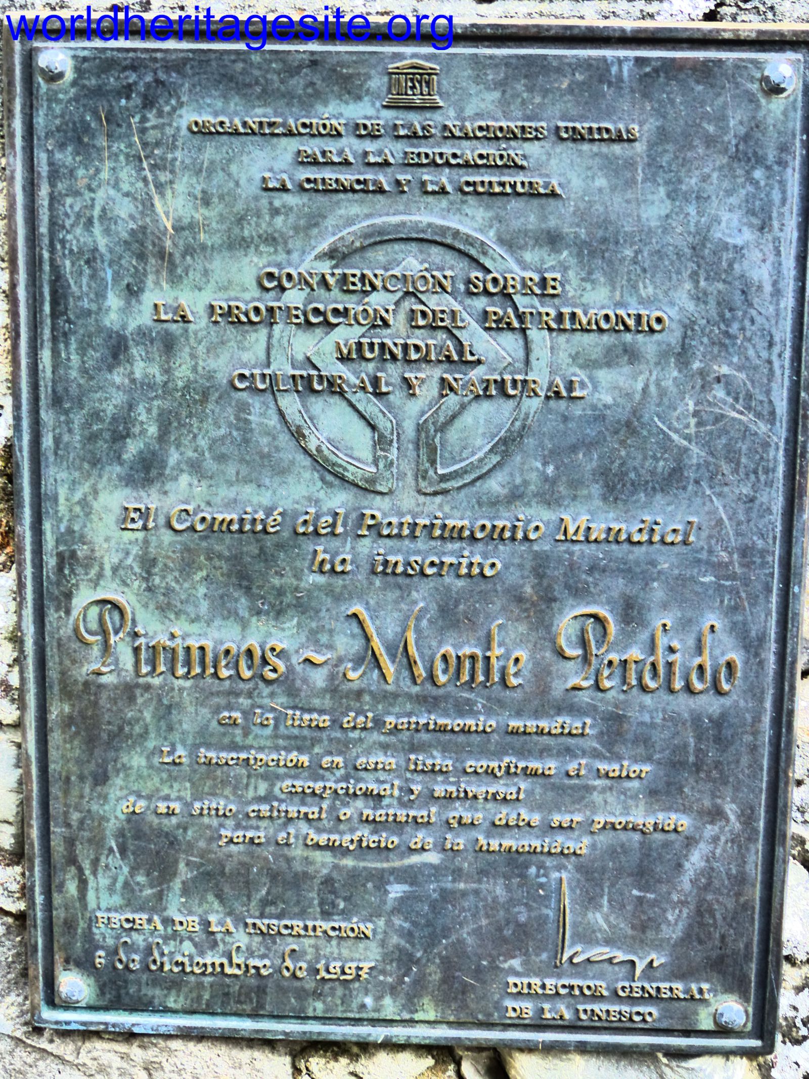 (photo by Clyde)