Te Wahipounamu
Te Wahipounamu - South West New Zealand consists of four national parks renowned for the scenic beauty of their wild mountain landscapes.
The area was shaped by tectonic, climatic, and glacial processes, resulting in fjords, glacial lakes, glaciers and moraines. It contains some of the best modern representations of the original flora and fauna present in Gondwanaland, such as kiwis, ‘bush’ moas, carnivorous Powelliphanta land snails and the endangered takahe.
Community Perspective: Comprising Aoraki/Mt Cook, Fiordland, Mt Aspiring, and Westland NP’s, “it could easily be split into a few different World Heritage Sites, because each area has such unique aspects”. Among the highlights, Squiffy has described Doubtful Sound, GabLabCebu and Nan the Franz Josef and Fox Glaciers, and Carlo Milford Sound and the Kepler and Routeburn hikes.

Map of Te Wahipounamu
Community Reviews
Carlo Sarion
Philippines/New Zealand - 02-May-22 -

I thought that this site did not need any additional reviews. I mean, it’s got heaps of testimonies already, and we all know it’s famous, iconic, and a well-managed site that boasts some of the most beautiful sceneries in the world. But it won’t hurt if this site gets another review, right? :D
The previous reviews had highlighted the OUV of this WHS already, so I would just focus on sharing my experiences visiting Milford Sound and hiking the Kepler and Routeburn tracks. Visits were on two separate occasions last March 2022.
1. Milford Sound/Piopiotahi
The night we arrived in Te Anau from Queenstown, my friend and I booked the tour for the following day, knowing that it would rain the whole day and the waterfalls would be spectacular. I wouldn’t say I like going outdoors in the rain, but this was one of the rare exceptions.
There were only about 20 tourists on the bus, and it was a typical tour bus where the driver also gave commentaries. We stopped at the designated tour spots such as the Mirror Lakes and Eglinton Flats despite the drizzle. We arrived at Milford Sound almost 2 hours later and were surprised that we were one of the only two buses there. COVID has drastically affected tourism in Fiordland—our driver lamented how they used to have a surplus of visitors pre-COVID. At the moment it was rare for their tours to even reach half the capacity, although I am pretty sure this would change soon when the border opens to international tourists in May 2022.
We set out to explore the fiord, but the rain had gotten worse. The boat skippers were enthusiastic about the downpour, even saying that we came when the fiord was at its most spectacular. Surely that was an attempt to make us feel better about the dingy weather, but there was truth in what they said: cascading waterfalls all over the surrounding mountains made the scenery dramatic. We went close to several falls and had the best time getting soaked. The entire experience was incredible, but I would definitely revisit Milford when it’s sunny, or more ideally, at the end of a long tramp through the Milford Track.
2. Kepler Track
The Kepler Track is within the Fiordland National Park, easily accessed through Te Anau. The Track is a sub-alpine loop and features gorgeous mountain and lake sceneries, river valleys, tussock, and rainforests. People usually start at the Lake Te Anau control gates, but some skip this by taking a boat ride to Brod Bay. Hikers would stay overnight at the Luxmore, Iris Burn, and Moturau Huts, making this Track a 4-day, 3-night hike. Some trampers would walk all the way back to Lake Te Anau control gates to finish the entire loop, but some would choose to culminate early at Rainbow Reach, where they would wait for their pre-booked transfer back to town. According to NZ DOC, the whole loop is 60km long, with an elevation gain of around 1,000m. My friend and I did the full-day Brod Bay to Luxmore Hut leg only as I was not able to secure any of the huts because they were “fully booked” at the time of research.
Pesky sandflies welcomed us at the start of our hike at Brod Bay. We quickly left the shore of Lake Te Anau and walked towards a thick forest of tree ferns (e.g., ponga, whekī), beech, and podocarp trees. The ascent was gradual at first but eventually became steep with lots of switchbacks. Halfway through the leg, we arrived at the limestone bluff, which was once part of a submerged reef system. We reached the tree line and the tussock field about a kilometer from the bluff. Here, we had to withstand strong winds blowing from the south while enjoying the views of Lake Te Anau and the mountains behind it. We arrived at the Luxmore Hut at around 11:30 am, where we had our quick lunch. We encountered only a handful of people in the hut, which wasn't surprising given that we arrived quite early. The views from the hut were fantastic, and I love how the clouds dispersed the sunlight over the lake. After finishing our lunch we decided to head back to Brod Bay. We bumped into less than 20 hikers during our descent. This was way below the capacity of the hut (max of 50 people), which made me think that several people might have cancelled their bookings on the day itself, unless there was an equal number of hikers coming from the opposite direction who would stay in Luxmore Hut for the night. The descent back to Brod Bay was punishing, and we had to stop several times before our knees got sore. Two and a half hours later, we arrived at Brod Bay and waited for the small boat that would ferry us back to the town.
3. Routeburn Track
Routeburn Track straddles two regions (Otago and Southland) and national parks (Fiordland and Mount Aspiring National Parks). It is a 33 km sub-alpine track that can be completed in three days and two nights, although some keen, physically fit hikers would do it in two days. I would say that it’s got all of the things you’d like to see in a subalpine track: ice-covered mountains, craggy peaks and towers, river valleys, tarns and lakes, cliffs, creeks, waterfalls, rainforests, tussock fields, and flats, etc. Views are diverse, breathtaking, and just a tad beautiful. It’s constantly being pitted against Milford Track, but I would say that Routeburn is a better option for those who are new to tramping.
I started the hike at Routeburn Shelter at 10 in the morning and ended the first day at Routeburn Falls Hut. The Track between the shelter and the hut featured dense rainforests and heaps of suspension bridges. A quick side trip halfway through the trail is the crystal clear pool at Forge Flat. From here the ascent was gradual until you reach the Routeburn Flats Hut. It is less popular than Falls Hut, probably because staying in the latter saves you an hour or so of ascent the following day. Halfway between Falls and Flats huts was the 1994 slip face that offers a magnificent view of the Humboldt Mountains. I arrived at Falls Hut at 4 in the afternoon, cooked dinner, chatted with fellow hikers, and waited for the ranger to give us the safety talk.
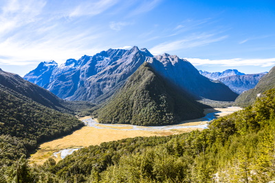
I began the second day relatively early as it was going to be a long walk towards Lake Mackenzie Hut. Negotiating the rocky steps just above the Falls Hut was tedious, but the Track went a bit level when I got to the top. I continued walking through the open tussock fields until I arrived at the stunning Lake Harris, which feeds the creeks and waterfalls below. Note that the Track along Lake Harris was narrow and exposed. Walking past the lake for less than an hour, I arrived at the Harris Saddle, which offers glorious views of the Hollyford Valleys and Darren Mountains (see photo). I ate my lunch here while watching other hikers negotiate the steep face of Conical Hill, a side trip from Harris Saddle that gives you spectacular views of the valley and even the Tasman Sea! Past Harris Saddle was the long traverse along the Ailsa Mountains. The trail is above the tree line and high cliffs, so caution should be taken when hiking this portion of the Track during bad weather. The seemingly endless serpentine appearance of the Track traversing the mountains was very picturesque. The hike ended with a steep descent towards Lake Mackenzie, where I encountered several juvenile keas happily swooping down on the tracks. Having a close encounter with these cheeky endangered birds was unforgettable. The vegetation and moss-covered forest floor just before Lake Mackenzie Hut had some cool LOTR vibe. I reached the crowded hut at 4 pm. I was so exhausted that falling asleep amidst the symphony of snores was easy.
The third day was spent navigating through the dense rainforests on the way to the end of the Track. Before leaving Lake Mackenzie, I went to Split Rock, an open field surrounded by mountains, which would have been spectacular during winter. I went back to the hut and had a brief rest before leaving at 10 in the morning (I was the last person to leave the hut). I proceeded through the forests for about an hour before I reached a forest clearing called The Orchard. About half an hour from The Orchard was Earland Falls, an excellent spot to take a quick break while marveling at the tall, gushing waterfall. A flood route is available in case of heavy rain. I continued walking for another hour before reaching Lake Howden, where I saw several hikers chilling and having lunch. I did not take a break at this point as I wanted to hike the Key Summit, a quick side trip with incredible 360-degree views of the surrounding mountain ranges! I could have stayed longer here, but I was worried that I would miss the 3 pm transfer back to Queenstown. At this point, my camera ran out of juice and my feet were already sore. Luckily, it was a quick and easy stroll from the Key Summit sidetrack to the end of the trail (The Divide). I reached The Divide at precisely 2 pm, and upon stepping at the very entrance of the trailhead I felt like I had accomplished something remarkable. What also made this tramp a great experience was the three straight days of sunshine with minimal cloud cover. I didn't think I would appreciate the scenery as much as I did if it was raining or the sky was overcast.
Visiting the Milford Sound/Piopiotahi and walking the Kepler and Routeburn Tracks look insignificant compared to what this place can offer. Still, I felt like these places adequately represent what we treasure about this site. I can’t wait to explore this site more—I’d possibly start with walks around Lake Manapouri and completing the Milford Track, before visiting the Fox and Franz Josef glaciers and the walks around Mount Cook/Aoraki.
Nan

In January 2020, we spent a week on the Southern island of New Zealand in and around Te Wahipounamu. When people say the Southern island is the more beautiful of the two, Te Wahipounamu is the main reason. It offers fjords, forests, glaciers and mountains in abundance that are very little touched by humans.
We started around Te Anau with a half day hike along the western shore of Lake Te Anau. It takes you directly into a massive fern forest. The next day we did the mandatory Milford cruise. It's takes you out to the ocean along the high cliffs of the fjord. You pass plenty of waterfalls and if you are lucky, you get to see some dolphins. The weirdest part is that the surrounding mountains seem so small, when in reality they climb above 1600m.
Personally, I enjoyed our stops along the way to Milford better than the actual cruise. You get several view points, most notably the Mirror Lake and the Eglinton Valley view point. If you are into rough hiking, you can hike to Lake Marian. We tried. But we got lost along the way. And due to time pressure from having to catch the ferry, we had to return before reaching the lake.
Two days later, we drove in a single day from Wanaka to Greymouth with stops at Fox and Franz Josef Glacier. This is the second mandatory component of any visit as the west coast is just stunning. First, you pass magical azure lakes (outside of the core zone) when you leave Wanaka. Then, you enter Mount Aspiring National Park with ample hiking opportunities. After you crossed the mountains, you reach Haast (4h or so). I wish I had known how stunning and different the scenery is around Haast. There are long white beaches, cliffs and river deltas to explore.
We drove past and stopped first at Fox and then Franz Josef Glacier. Fox offers the better nature. Franz Josef the more accessible glacier. You should visit both. For both glaciers, it has to be pointed out that climate change has taken it's heavy toll with the glaciers shrinking every year.
When we left, it felt too early. This is a great national park and there was so much more to explore. So, why isn't it 5* for me? Partly, because the site is too large too fully grasp. You probably have to spend weeks hiking to fully appreciate the scenery. But when I compare it to Los Glaciares, it just doesn't have as iconic locations as the Perrito Moreno Glacier or the Fitz Roy mountain range.
In the forum, me and Solivagant had a discussion regarding his rating. I pointed out that Fjordland (which is just one of the components of the site) is very similar to the Norwegian Fjords and should at least receive the same rating. His point was that his rating was tainted by bad memories (has happened to me, too), the weather and the crowds. To me, the crowds are a misunderstanding. It's more a function of how little of the site is accessible by car. Most tourists concentrate around the same hot spots (Milford, Fox, Franz Josef) and I guess that's intentional by the authorities to protect the wilderness. With some hiking or deviating a bit from the standard route (Haast), you should be able to get away from the crowds quite quickly.
Getting There
That's a more difficult one than normally as the "there" is pretty big. The inscribed area covers most of the South-Western part of New Zealand's South Island. It's more than 400km beeline, with significantly longer travel distances as some areas are not passable at all. In total, the inscribed area is 26000 km2, roughly the size of Ruanda. Keep in mind, though, that the fjords and lakes and Fjordland were originally excluded. They are now proposed as an extension to the site on New Zealand's tentative List.
Generally, you are best served with your own car. There are buses, but I did not investigate this option. When driving, you cannot plan trips the way you would elsewhere. Roads are constantly being repaired, so plan buffer and be able to adapt your plan. In 2019/2020, there were repeated incidents where tourists were locked between Greymouth and Wanaka as the single road going in and out of this huge area was closed. See my comments in the forum on general recommendations re travel in New Zealand.
The biggest city of the area and the central hub is Queenstown. It offers all the tourist infrastructure you would expect including a small international airport and a LVHM store. We flew in from Sydney. Queenstown prides itself the adventure capital of the world. Bungee jumping was invented here. As were jet boat rides in canyons. And there are many more options nowadays. All of them are rather pricey, though, and they attract a special crowd.
If you plan to explore the Fiordland NP some more, I would recommend basing yourself in and around Te Anau. From Te Anau, you can explore Milford Sound on your own and do plenty of the stops along the road to Milford as a day trip. You can also do the Doubtful Sound cruise from Manapouri which is pricier than Milford, but probably less crowded.
Further North of Queenstown, is Wanaka. To me, it's the way more pleasant alternative to Queenstown. From there, you have access to Mount Aspiring National Park and the west coast road.
Along the west coast road, coming from Wanaka, the first town after you passed the mountains (which takes 3-4h) is Haast. We didn't have time for a proper stop in Haast, but the little I saw was intriguing. It's a completely different scenery with long white beaches (see picture).
The last stops on the west road are the Franz-Josef and Fox Glaciers. Around Franz-Josef and Fox Glacier small tourist towns have sprung up. We didn't stay there for the night, but continued the same day to Greymouth. Greymouth is the next major town on the west coast. It has a certain abandoned charm to it. It's also home to a brewery and the end point of the (tourist) railway from Christchurch.
For Mount Cook, Twizel seems to be the base. However, the recommended itinerary is to take the stunning west coast ride, so not sure how you would squeeze this in without a detour.
Cruises
The default cruise is the Milford Sound cruise. Plenty of operators compete for your attention, but at the end most offer the same trip, taking you once out to the sea and back with some stops at (or below) different waterfalls. Most guidebooks will recommend doing the cruise in the evening as it's less crowded. Having done so, I would disagree. The boats were still lining up like on a parade in the fjord and we were time pressed all day due to having to be in Milford by 15:00h. I am not sure you need to prebook as we came in high season and all operators were offering tickets for immediate departure. There are day trips including bus and cruise from Queenstown.
As an alternative or an addition, you can do the Doubtful Sound cruise. It departs from Manapouri, but you can also take a shuttle from Te Anau. You cannot do this from Queenstown. Doubtful Sound is harder to reach as you have to take a ferry first, then a bus across a mountain pass, before you reach it. As a consequence, it's likely less touristy and the more intimate experience. We had booked a kayaking tour, but it got cancelled due to heavy winds, so I can't compare.
Hiking
To get away from the road and see some of the nature, you will have to hike. To see the Fox Glacier and Franz Josef Glacier there are friendly walking trails. To get on the glacier requires a tour. In Mount Aspiring, the Rob Roy Track is renown. Technically not part of the core zone, but with great views of the Southern Alps, is Roys Peak. You have probably seen the view before as the viewpoint on Roys Peak is the selfie place for any NZ tourist.
If you want to go all in and do a multi day hike, the area boasts three great walks:
- Milford Track takes you from Te Anau Downs to Milford Sound.
- Kepler Track takes you from Te Anau in a circle. We hiked the first bit of it in an afternoon. Very nice. If you plan to hike, either park at the hydro power station or take the morning/afternoon ferry from Te Anau across Lake Te Anau. The eastern shore is not very memorable.
- The Routeburn trail will take from Glenorchy (North of Queenstown) to Milford Sound.
There are many more options, so investigate. You should be aware, that you are leaving civilization quickly, so come prepared. In high season, the tracks, specifically the Milford Track, require a reservation.
Two things to keep in mind when hiking:
- The rivers carry some dangerous bacteria. Clean your shoes and stay away from the water.
- There is very dangerous poison nearly everywhere to eradicate non native species. Watch your kids.
Flying
For several sites you can book a helicopter ride. E.g. you can be flown on a glacier (Fox, Franz Josef). Or you can cross the Southern Alps by plane with views of Mount Cook. It's a pricey option, though, and I also would feel guilty re CO2; flying to NZ is already bad enough on its own.
GabLabCebu

WHS#4
As a world traveller, I often get asked which country I loved the most. To answer that question, I usually look back on how surreal every day was in each country, how wonderful it was to just wake up and see paradise, to feel like you're in the most perfect place in the world. For me, that's New Zealand. I visited a long time ago, on a family road trip back in April 2013, but it's still one of the most memorable landscapes for me. This WHS experience was actually a good motivation and eventually, outcome of my first work in travel itineraries. My family had originally planned to go down the East Coast of the South Island through Christchurch before ending in Queenstown. I, however, had different plans. I wanted to go down the West Coast because of my interest in gemstones, and Hokitika on the West Coast is a haven for local gemstones, especially known as a jade (locally known as pounamu, the namesake of the South Island) locality. I didn't really get to hunt for jade on the beach, but I got an even more memorable adventure on this scenic route. The route down the West Coast from Picton to Queenstown brought me to Westland Tai Poutini National Park and Haast, as well as Fjordland National Park, which we visited on a day trip from Queenstown. Those few days just barely scratched the surface of this vast land. It's one of the most visually pleasing landscapes, with an extensive geological and glacial history, and some of the most unique flora and fauna on the planet. All of these different properties meet awe any visitors lucky enough to step foot on and set their eyes onto the greatness that is Te Wahipounamu.
Driving south from Hokitika, you'll enter the core zone around Franz Josef Glacier. Franz Josef and Fox Glaciers are among the most important stops and impressive sights in this huge WHS. They're unique in that they descend to such a low altitude in a subtropical climate., which makes them extremely accessible to tourists. This, of course, includes me as I walk up the glacial valley towards the glacier itself. The glaciers have definitely seen better days, and it shows in the dramatic rock formations of the valleys they carved. All the while, temperate rainforest thrives on its walls. The main difference between the 2 glaciers, at least in terms of visitor experience, is that Franz Josef's trail approaches the glacier from the front by the flat floor of the valley, while Fox's trail traverses the wall of the valley, allowing one to look down on the glacial stream and eventually, the glacier itself. Regardless, one cannot access the glacier itself without a licensed guide and equipment for walking on the ice. For me at the time, I guess seeing the great rivers of ice from the established viewpoints were enough, but I'd love to be able to walk on the glaciers, and I just hope they'll survive until I get the chance.
Close to Fox Glacier is Lake Matheson, a glacial lake with a perfectly reflective surface. Mount Cook, the highest mountain in New Zealand, can be viewed from here. It's also part of the WHS as Aoraki Mount Cook National Park, though I wasn't able to visit this part of the site. Down the coast, the highway reaches Haast before curving inland to cross the Southern Alps. There are many things to see in this frontier of civilization, but the only site I remember visiting Knight's Point. This is a lookout point on the coast where you can view birds and seals. Unfortunately, my main memory of this was the unpleasant swarm of insects here. Crossing the Alps through Haast Pass, I exited the WHS towards Wanaka. To me, the lakes here deserve recognition along with the WHS. The glacier-carved Lakes Wanaka and Wakatipu are not just of great aesthetic value, but of great geological interest, pristine condition, and interesting mythological properties of the Maori. Queenstown, of course, is one of my favorite little cities in the world, simply for its atmosphere of being one with one of the greatest landscapes of the world.
It was also from Queenstown that we visited what is probably the highlight of this WHS: Fjordland National Park. This is the wildest, most dramatic, most scenic, and arguably the most untouched corner of New Zealand. I say arguably because there is a highway all the way to Milford Sound, where one can board one of the several cruise ships that go to the mouth of the fjord and back. Otherwise, I remember the landscape being unaffected by development, as ecosystems appeared completely healthy and intact, and no infrastructure severely hindered the aesthetic impact of the land. From Queenstown, stops include the lakeside town of Te Anau, Mirror Lakes, some waterfalls in the temperate rainforest-covered cliffs, and a stream from which we were allowed to drink - yes, the water tastes amazing! Finally, we arrived at the little settlement at the inner end of the fjord, where we boarded a boat that took us to the various highlights of the fjord, such as the many waterfalls, views of the mountains and the sea, outcroppings covered in seals, and boulders of pounamu before emerging at the mouth of the fjord. From here, you can't even imagine that you had passed by the huge towering snow-capped peaks on a boat. It's as if the fjord was never there. Even though the waters are apparently not part of the WHS, they are an integral part of the ecosystem and scenery here.
Obviously, I missed a lot of the important properties of Te Wahipounamu. I was unable to visit 2 out of the 4 national parks that comprise most of the core zone, but I was also unable to observe much of the extraordinary flora and fauna in these parks. But purely from the "many of the natural features which contribute to New Zealand's international reputation for superlative landscapes," I was, even as a child, able to recognize that this is truly a top-tier natural landscape of the world.
Squiffy

The incessant rain dripped from my sunhat. My jeans were clinging clammily to my legs. My surroundings lay lost in the cloud banks that enveloped the little boat, creating an aura of mystery and suspense. Alone on the upper deck I braced myself on the rail as we cut across the mouth of Doubtful Sound, roiling and bucking with the waves.
Te Wāhipounamu World Heritage Site is comprised of four contiguous national parks running up the southern west coast of New Zealand’s South Island. From south to north these are Fiordland National Park, Mt Aspiring National Park, Westland National Park and Aoraki / Mt Cook National Park. Our trip to New Zealand had been scheduled to take in the first three of these. As it was, due to being ripped off by a campervan hire company and being left stranded in Queenstown with no transport, no accommodation and no money to pay for either, our once-in-a-lifetime trip to New Zealand ended up starting and ending with a single day trip to Doubtful Sound in Fiordland before we had to fly home early (New Zealand remains the only place I’ve visited where I was glad to pay more to leave the country sooner than planned).
Doubtful Sound, the less visited southern sister to the more famous Milford Sound, requires a full day – though it depends on where you start from. Tours – you can search for them yourselves - leave from the town of Manapouri at 10am sharp, so if you are an early riser you potentially could leave the tourist hub of Queenstown before the crack of dawn, drive flat out and get there in time, before doing the same in reverse at the end of the day. I think organised tours by coach also permit a day trip. We didn’t fancy our chances and so we booked accommodation for two nights in Manapouri. I would certainly recommend that as an option if you have time and money and your own set of wheels. But book ahead – on our tour 43 of the 45 available spaces were taken.
The journey to the sound is itself a bit of an adventure. It has three stages:
- A crossing of Lake Manapouri by catamaran, gliding past steep forested islets as you head towards the soaring Southern Alps. The catamaran docks in West Arm where a hydroelectric power station perches on the bare rock like a Bond villain’s lair; at this point you have entered both the national park and the world heritage site
- Transfer to a 1981 vintage coach with bench seats and a temperamental heating system. This redoubtable old workhorse pulls out onto the only section of road in New Zealand not connected to the rest of the road network and shuttles you up and over the Wilmot Pass to Deep Cove. Though the word ‘shuttle’ implies speed, which is quite at odds with the nervy journey as the coach ground its way up to the pass, gears protesting, and the even nervier drop back down again as a heavy foot was needed on the brakes as the road wound between a steep rockface to the right and a sheer drop into a valley to the left. The journey does, however, provide a first glimpse of what makes this area so wild and valuable. This is a proper rainforest, primeval and untamed, tangled beeches larded with moss, trunks green, beards hanging from branches, clouds pressing close, drizzle falling from leaves, rushing and tumbling along the roadway.
- Arrival at Deep Cove in Doubtful Sound where the cliff plunges down into water the colour of iced tea.
Doubtful Sound is meant to be a connoisseur’s choice. Milford Sound offers competing tour companies, a range of adventure activities and the end of the famous Milford Track. Doubtful is far less visited. The selling points, as explained to me, were that it was larger than Milford Sound and also quieter. Without having visited Milford I don’t feel equipped to make a full comparison. However, I would comment that I was in no place to judge the size of Doubtful because we spent the entire journey swaddled in cloud. Other than when we nosed up to the cliffs to wonder at the cascades of crystal-clear rain- and melt-water the surrounding landforms were only dark shapes in the mist. And I could not judge the silence either because the engines of the boat thrummed constantly underfoot to keep us from being driven into the rocks. I did have some joy at spotting wildlife though, with three New Zealand fur seals and four rare Fiordland penguins being spotted.
Would I visit Doubtful Sound again? Well, my experience of New Zealand was rather soured by the treatment we received there and I did vow in anger to never return. But the reasons I wanted to visit in the first place remain valid, I suppose, so my opinions have mellowed slightly over the intervening two years. I would still like to properly have my once-in-a-lifetime trip to New Zealand, and exploring more of ‘the place of greenstone’ would form a decent chunk of that. But next time I might take the easier option and opt for Milford Sound instead. Purely for comparative purposes, you understand.
World Heritage-iness: 4.5
My Experience: 2
(Visited Nov 2016)
Gary Arndt

I visited Te Wahipounamu in July of 2007.
Te Wahipounamu is the Maori word for what is the fjordlands area in the southwest corner of the South Island of New Zealand. This includes the famous Milford and Doubtful Sounds.
I did a tour of Milford Sound and had the pleasure of going immediately after it had rained for 24-hours. Water was flowing down the sides of the fjord in hundreds of small waterfalls, and the large waterfalls were going at full flow.
Visiting can usually be done on a day trip from Queenstown, but you can also stay in the region to do and experience more.
Read more about Te Wahipounamu on my website.
Michael Turtle

The hardest thing about this WHS is knowing where to start... and where to stop. It's not just enormous in terms of area, it has such an incredible amount of diversity. In some ways, it could easily be split into a few different World Heritage Sites, because each area has such unique aspects.
As a visitor, I think the best thing is to hire a car and take your time driving along the coast over a number of days, stopping for different walks and viewpoints.
One of the highlights (for me) was the glaciers - particularly Fox and Franz Josef. The sad things is that they are receding so quickly at the moment. Part of that is just the natural ebb and flow but the human-caused climate change is also having a big effect. I wonder how long they will last. Will there be a generation soon that won't be able to see this?!
Read more from Michael Turtle here.
Tom McSherry
As a local who has completed two full tours of the country, I have to say there is no other part which quite creates the sense of travelling into the prehistoric past the way Te Wahipounamu does.
It's so simple to find a quiet spot where you can contemplate how little the landscape has changed here over the aeons, to get some perspective on how damaging the presence of humans is - and how important it is to ensure areas like this remain free of that damage. Then there is just the sheer, raw natural beauty of the place - it's a cliche to say it leaves me speechless, but that truly is the effect.
Read more from Tom McSherry here.
John booth

I was enraptured when I read the reviews already on this page.
In April I made the 1000 km journey to the bottom of the South Island. This is the real New Zealand, far removed from the city life that I endure in Auckland.
Most people travel to these remote areas by car, but if you are travelling alone, or feel that is too un-green, be assured that I toured the whole area from and back to Christchurch by local bus and train services. Because of the tortuous nature of the roads there I would recommend this as it allows you watch the scenery instead of the road.
From Christchurch there are direct bus services to Te Anau, Queenstown, Mount Cook and Greymouth, as well as the scenic rail link to Greymouth that I used.
From Te Anau there are several services to Milford which connect there with boat trips up the Sound.
From Queenstown there are bus services to Te Anau (for Fiordland), to Glenorchy and Wanaka (for Mount Aspiring), to Fox and Franz Joseph Glaciers (for Westland) and onwards to Greymouth.
For the more energetic there are walks on the Milford and Routeburn tracks that lead through the Fiordland and Mount Aspiring National Parks respectively.
Emilia Bautista King
Ah, New Zealand! I travelled for 3 1/2 weeks on both North and South Islands. Fiordland National Park is stunning but watch out for those keas (alpine parrots) that will tear their beaks into anything in their path, including your car! I took a boat tour on Milford Sound and felt like Jacques Cousteau. The waterfalls were beautiful and what a thrill it was to see seals on the rocks! On the boat, I went fishing for the first time with a makeshift rod that the boat crew gave me. Didn't catch any fish - just fed them with my bait!
Ben Pastore
In a land of superlatives, Fiordland National Park earns the highest ranking possible in all around natural beauty. My jaw hurt from repetitive dropping as we made our way to scenic Milford Sound, passing through majestic glacier-topped mountains ringed with temperate rain forest. At Milford Sound, I suggest the boat tours, as the raging waterfalls, dolphin encounters and lazing seals are best seen from this vantage point. I have traveled extensively and I do not say this lightly when I call this area the most beautiful spot on earth.
Gatis
I am a bit surprised to see how many beautiful, world-class things Newzealanders have managed to "throw in one basket" with this monument. In fact Te Wahipounamu is quite big and extremely diverse natural area, and some other nations may be would make some five World Heritage sites out of it.
To me was a surprise to see so few people and so little development in Fiordland. Humans have managed to build here some prety good roads and some smaller cities and villages, but everything else is rugged mountains, dense coastal rainforest, incredible waterfalls, magnificent ocean - fairytale land (see "Lord of the Rings").
Community Rating
- : Ailton007 Christoph Roman Raab MoPython Jakob Frenzel Mihai Dascalu Mikeyboyracer Hammeel Preiki Vicente B. Avanzado Jr. Daniel C-Hazard CalvinLoh Frederik Dawson Julio Moreno Carlo Sarion Shep894 Bodil Ankerly Don Irwin Wieland GabLabCebu JobStopar
- : Nan Bill Maurmann Shandos Cleaver Squiffy Csaba Nováczky ALS Timonator Chapnis MichaelH Matthewgibbs Francky D'Hoop Tango
- : Panacci Gary Arndt George Gdanski Mikko Larry F Luboang PabloNorte Kevin247 Johan Ralf Regele Jeanne OGrady
- : Solivagant Zizmondka Naim Y
- : Jeffrey Chai Ran BMuramatsu
- : Alexander Parsons
Site Info
- Full Name
- Te Wahipounamu - South West New Zealand
- Unesco ID
- 551
- Country
- New Zealand
- Inscribed
- 1986
- Type
- Natural
- Criteria
-
7 8 9 10
- Categories
- Natural landscape - Glaciation Wildlife habitat - Fauna
- Link
- By ID
Site History
1990 Extended
Encompasses the in 1986 inscribed parks Fjordland and Mount Cook
1986 Inscribed
Site Links
Unesco Website
Official Website
In the News
Connections
The site has 44 connections
Damaged
Ecology
Geography
Individual People
Literature and Film
Timeline
Trivia
WHS Names
WHS on Other Lists
World Heritage Process
Visitors
198 Community Members have visited.
The Plaque
 (external source)