Madriu-Perafita-Claror Valley
The Madriu-Perafita-Claror Valley is a pastoral landscape reflecting an agricultural way of life that was once widespread in the upland regions of Europe but now survives only in this part of the Pyrenees.
The valley was a place of passage with tracks linking it to France and Spain. Shepherds, charcoal burners, miners, blacksmiths, farmers and even smugglers have used these footpaths over the centuries. It corresponds with the Madriu river basin. The highest part is a glacial landscape, the rest was and still is used as pastures for the grazing of cows and horses during the summer. The two settlements within the valley are only used in the summer months. Terraced fields have been constructed to grow rye, and wheat and to provide hay. The land is communally owned.
Community Perspective: A number of marked trails lead into the area. But as beautiful as the scenery might be, it will not bring you closer to understanding the cultural value and one reviewer even wondered how alive the pastoral tradition really is.
Map of Madriu-Perafita-Claror Valley
Community Reviews
2Flow2

This is an area with some very beautiful hikes! I recommend a visit after seeing it in May 2025!
Now, whether this site is of "outstanding value to humanity", as many reviewers have commented, is debatable. As Els mentioned in her review over a decade ago, it's questionable the extent to which this site "reflects the persistence of pastoralism and a strong mountain culture, notably the survival of a communal land-ownership system dating back to the 13th century" as the inscription claims. The Madriu-Perafita-Claror Valley is located decently near Andorra's main highway that connects the whole country, and is close to the city of Encamp, which itself feels fairly like a mix of any generic Western European nation blended together with any outdoorsy city in the the modern American West. The amount of people doing intense outdoor biking and the number of trendy outdoor gear shops astonished me, but I didn't see anything that really reminded me of "pastoralism".
If you treat this as simply a nice hike with the added bonus of you getting to "check" a WHS (or a visit to Andorra, for that matter) off your list, then I think you will enjoy this. There are a whole host of trails, and the Valley's official website has a ton of different recommended routes (13 as of this writing) categorized by "Low", "Moderate", or "More" difficulty. If you are extra particular about trying to immerse yourself in the "core" zone of the WHS region for as long as possible, read the other reviews on this site for some pointers. Do be aware that while for some countries a "Low" difficulty means level, simple (sometimes paved) trails for a hike, Andorra is not one of those. You should be in decent shape to hike the trails here, because even those of the "Low" difficulty (such as my group did) contain significant inclines and traverse across uneven rocky paths.
I followed the advice of James F's review to plan our hike and we went to Coll Jovell, which is a very pleasant lookout point that makes for some decent pictures. From Coll Jovell you can do a full loop, or if you are really pinched on time you can just descend the way you came up and do the whole experience in only 1–2 hours.
James F

Visited June 2024.
As this is one of my first reviews, I will aim to limit myself just to the important information reviewers before me have not covered. The situation seems to have changed somewhat since the signage situation was most recently reviewed, which is principally what I will cover here.
As with all my trips, I challenged myself to do this without my own vehicle or any private vehicle.
I'm hardly a strong hiker and always conscious of doing stuff like this by myself. Like many other reviewers, I opted for the route to the Fontverd Plateau and found it -- if not nothing -- completely accessible and felt safe the whole time.
Andorra La Vella is more giant mall than European capital, so I opted to see this site en route from Toulouse to Barcelona, making use of the Andbus service leaving at 9:45 from Toulouse and arriving in Barcelona around 23:00. It would also be doable as a daytrip from Barcelona, but not from Toulouse as it leaves too little time in Andorra itself.
I took the bus through the parish of Encamp (not to be confused with the town of Encamp which is quite far from where you'll want to be). From here it is a short walk to the starting point of the 'Lakes Circle'. All the 'information points' I saw listed in Google Maps in this area appeared to have been closed for some time. Perhaps this is -- as other reviewers have mentioned -- because the maps they provide(d) are hardly necessary.
The walk is divided into three stages:
- The hike up to Col Jovell, where the World Heritage Site begins. This is marked with a red and white lines. This is a very well paved path through a pine forest with views over Les Esclades. It is mainly uphill and I made use of the many benches en route to catch my breath. At the clearing near Col Jovell, there is a sign marking when you have entered the World Heritage Site. There is also a small metal engraved box explaining why the valley is a World Heritage Site. This section took me about 45 minutes (including rests).
- The northern route to the Fontverd Plateau, also marked by red and white lines. This path takes you down into the valley before a rapid re-ascent as you approach the plateau. It is very well marked and -- if rocky -- the path is wide and very obvious. Many people seemed to be running the full length of it. It provides the best views of the pastoral system that is supposed to be occurring within the valley. You can even make a short detour to the stone walls and some of the donkeys they were intended for. There are several shepherds' huts along the route, now marked by signs saying they are private property by virtue of their UNESCO status (!!?!?!?!?!?!?!), but at least there's some recognition now. This is by far the toughest stretch of the walk, even though it looks enticingly easy from Col Jovell due to its descent. It took me 90 minutes, virtually half of the time I spent on the whole hike.
- The Fontverd Plateau itself is a really gorgeous spot. There is another metal engraved sign here now explaining how the plateau was used by and integral to the pastoral system.
- The southern route back to Col Jovell, marked by yellow dots. This path maintains a near-constant altitude along the side of the mountain and is thus easier, but a) doesn't allow you to see anything that makes this a WHS and b) it's a far more 'rough and ready' path, sometimes over boulders on the face of the mountain. I wouldn't have felt comfortable doing this route if it were windy or had recently rained, put it that way. This section took me about 30 minutes.
In hindsight, I likely would have preferred doing the southern route first, followed by the northern route.
All in all, a lovely walk but average-to-below-average WHS, like others have said. At least there have been some attempts to 'sell' the WH status, owing to the fact that this is clearly the most popular route and probably the most "bang for your buck" in terms of the % of the site you can appreciate for your time invested.
I arrived in Barcelona later in the evening, very satisfied with the amount I got to see without having to overnight in Andorra!!
Thomas Buechler
I hiked from Escaldes (start from Hotel Muntanya on Avenida Carlemany close to the square with the Carmen Thyssen museum), there is a signboard Cami de la Canaleta, this is the shortcut that leads to the Repsol gasoline station, cross the road, and continue steep uphill on Cami de la Muntanya, this leads you in about 45 min to the official entrance with signboard of this UNESCO site. Around here is also a big parking, it is the same road that passes here to Engolasters, first the village with the San Miquel church, then the lake. But just to say: You can do it without renting a car in Andorra which was in my case impossible on an extended weekend Andorra was loaded with tourists, mostly from neighboring Spain. About 30 minutes into the hike from the parking comes the first waterfall, and stone houses as well.
Joel on the Road
I visited this WHS in April 2017 with my wife and dog. Signage seems to have improved since the visits of previous reviewers, as there's now at least a "Welcome to the WHS" sign (two of them, in fact!).
We drove our car up to the hotel at the top of Engolasters and parked in their parking lot, before walking into the forest. It's about 90 minutes walk from here to the start of the site, and it's a very pretty trail through pine forest, over rocks and through a small tunnel as well. For most of it there are great views back to the city of Andorra La Vella.
There is a look-out at the border of the actual world heritage area from where you can see most of the valley, but since all three of us were tired we took some photos and decided to turn back. Pressing on would have required a serious downhill walk and then a serious uphill walk as well! You can see some evidence of the shepherd's huts and trails from this vantage point, albeit at quite some distance.
Overall it's not the greatest site we've been to so far, though if we'd started earlier and been fitter we might've found it more interesting!
Read more from Joel on the Road here.
Hubert

The Madriu-Perafita-Claror valley is the last remnant of a pastoral landscape in Andorra, whereas the rest of the small country has developed during the past decades almost entirely in a ski resort and a shopping paradise for bargain hunters. The valley has been preserved mainly because it is connected with the rest of Andorra only by small paths, there are no roads.
We visited the valley in May 2014. The tourist website of Andorra suggests several hiking routes within the inscribed area, we had chosen the Madriu valley route: a 13.5 km route starting in Les Elcades alongside the Madriu river up to the Lake Bova, and on the same route back. We started our hike at the old Pont d'Escaldes and followed the Carni de la Muntanya uphill. This section is already in the core zone of the WHS. After one kilometre, near the crossing of the Road Cornella I de la Plana and the Road to Engolasters, we reached the area of the National Park. An information board explains the flora and fauna of the valley, but there is no WHS sign. The route runs constantly uphill, in the first two thirds on a stone paved path, certainly convenient in the past for donkeys and mules, but strenuous for hikers, in particular downhill and as on our tour, because the stones were slippery from the rain in the night before. We passed drystone walls, terraced fields and huts, but we've seen no cattle and no shepherd. The valley was almost deserted, we met only a few other hikers and some locals who worked on the renovation of a farmhouse. It is surprising to find such a remote area in short distance to the busy traffic and the crowded city. After one and a half hours we came to the hamlet Ramio, one of the two settlements in the valley, and after another 45 minutes we reached the Fontverd refuge. This section is identical to a part of the route described by Els above.
After Fontverd we saw more huts and a few buildings that could be the remains of the iron smelting, but I'm not sure. In the last section of the trail we left the Madriu river and walked uphill to the Lake Boca (photo) at a height of 2400 metres, rather a wetland covered with cattails. It was a special atmosphere, a bit sombre and melancholy, due to the windy and cloudy weather and due to the fact that we were all alone, no other hikers and no sound, only now and then the cry of a vulture or an eagle and our own voices. Another 30 minutes uphill and we came to the Lake Illa at the eastern end of the core zone. Then we went back on the same route.
It is not a brilliant WHS and the mountain scenery is more impressive in the Mont Perdu WHS that we visited a few days before, but we enjoyed our day-trip. The capital Andorra la Vella is not worth to visit, the historic centre consists of the Casa de la Vall, the seat of the Andorran Parliament, and a few narrow streets around. The rest of the city looks more like the duty free zone of an airport than a lively city centre.
Els Slots

This WHS can only be reached on foot: there are no roads leading into the core zone. I started from the kiosk just below the Hotel Camp del Serrat at the Lake of Engolasters (where I stayed overnight). The kiosk gives away hiking maps, and I was handed one focused on the Madriu Valley including explanations on why it’s a WHS and what’s to see. So the Andorrans must have improved on advertising their only site on the List. There still are no signs however, so you’ll have to do without souvenir pictures of yourself posing before a “Welcome to Madriu WHS” signboard.
I had chosen to do the Fontverd route, a 13km hike to the Fontverd plateau which has a refuge and a cabin. This route partly follows the red-and-white striped GR-11 long-distance path into the valley. The trail is easy to find and you do not really need a map. What I did use the map for is to look for some 'things to see' in the valley of cultural value. They are few and far between: some Orri (shepherd's huts) are shown, but all are deep into the mountains and not near to any of the easier hiking trails. So I just decided to enjoy the walk and let the surroundings surprise me.
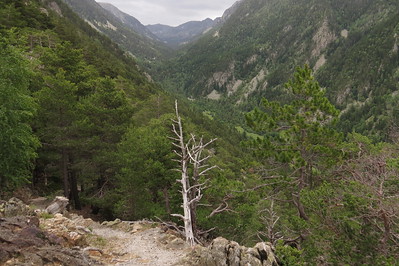
The core zone starts from the Col Jovell, about 45 minutes into the hike and after a steep ascent. Just over the edge of this mountain ridge is the best view into the valley itself (see large photo above): until that point, it is hidden behind various forested mountains. The valley is remarkably narrow. With the zoom lens of my camera, I could spot some stone buildings in the distance. What looks like a little church actually is the 20th-century hydroelectric system, where the Madriu river provides 11% of Andorra’s electricity. The river also supplies 20% of the nation’s drinking water.
The trail into the valley is narrow and rocky. I passed terraced fields with drystone walls and some abandoned farms. The cultural link of this WHS is a thin one: it’s a good thing that this last “original” piece of Andorra is saved from commercial exploitation, but I wonder how alive the pastoral tradition really is. And the trail could do with some interpretative signs. Maybe some future reviewer with better mountain hiking skills than I have could go just a bit deeper into the valley: the next point on the trail is “La Farga” where there are remains to be seen of the early steel industry in the valley. I wonder how much of that is visible.
Just when I reached my finish at the Fontverd plateau, it started to rain. I sheltered for a while in the refuge (where you can stay overnight too). But the dark clouds kept on coming so I headed back. I took the yellow-dotted trail back to Col Jovell, this one is easier as it involves less climbing. But the effect of pouring rain on myself and the rocky path gave this excursion a tough 1h45min ending. In all it was a nice half-day walk with some fine mountain scenery, but not a brilliant WHS.
Clyde

I visited this WHS in May 2014. There was no information apart from a few hiking trail signs and no sign anywhere informing people that this is a WHS or indeed a national park for that matter. Over the internet I found a list of different trails that do pass from the main core zone of this WHS and since I didn't want to spend days of hiking after having visited the Ordesa Valley a couple of days before, I opted for the shorter hike from Encamp to Engolasters which offers a couple of panoramic views and a few streams of water from the melting snow on the mountain peaks. In Engolasters, at 1616 metres, there is a lake in a glacial depression with clear turqoise water and plenty of fish. There's also a small church originally built in the 11th-12th century called Sant Miquel d'Engolasters which is very similar to the ones in the Val de Boi in Catalonia, Spain. Those were the main highlights of my visit together with the many birds of prey present in the valley. More effort should be made by Andorra to provide some information boards along the various hiking trails and to promote this WHS instead of only promoting the many shopping centres only.
John booth

I visited Andorra in July 2008, and also found little information about accessing the WHS at the Tourist Office. But I did find a minibus that went from Escaldes to Engolasters, a resort high in the mountains. From here there were a number of marked trails through the forest, one of which led to a viewpoint from where there was a panorama of the Madriu Valley.
Iain Jackson
I visited this site in August 2008. The weather was very pleasant with lots of sunshine and a cooling breeze at higher levels.
This site is also a National Park, which is (I think) co-terminous with the WHS.However I found no WHS plaque nor acknowledgement of its NP status.I saw no NP staff, nor interpretative material of any sort, only a very few footpath signs (tho' the system of paint flash waymarks was mostly very good) and no signs of agriculture or forestry. What few buildings there were seemed to be abandoned and there appears to be no public vehicular access.
This is a cultural site but nothing seems to be done to tell the visitor what (s)he is looking at.
Given the Andorran predeliction for covering all available land with shopping centres and/or ski resorts the cynical might conclude that this area was recognised as too remote and too steeply sloping to have any such potential and therefore designated as a NP and WHS in the hope of bringing in the tourists and their money that way.
To try and get a feel for the site I had decided to follow a route which a leaflet from the Tourist Office told me had a Difficulty rating of "Medium to High" and involved a climb of 970m. With an hours walk at the beginning and end to and from Escaldes to the Start point I anticipated quite a tough day.
Having been a bit grumpy so far in this review I want to say that I thoroughly enjoyed the day. Unsurprisingly the early part requires a long slog upwards, made pleasant by the attractive mixed woodland thro' which one passes. At Entremesaigues I took a right turn into the smaller Perafita valley, eventually emerging from the trees into the sunlit uplands. Here there are two refuges, both pretty squalid, and from where my onward route was not clear. Fortunately 4 other walkers arrived with a good map and pointed me in the right direction. At this level the sight of marmots and their surprisingly loud squeaks can be enjoyed.
Continuing up to 2450m, the highest point on my walk, I saw lots of wild(ish) horses and then began the steeper descent into the Madriu valley. From here an easy route follows the river all the way back to Escaldes
Here I was happy to relax with a beer or two in a friendly cafe before getting the bus back to my lodging.
So, to summarise I had had an uplifting trek thro' beautiful and almost deserted, scenery (which I'd whole-heartedly recommend) but I'd have learned more about the changing way of life in a marginal upland area from a day's walk in the North Pennines.
Community Rating
- : Inigo Cia LuHa CHJLondon Persian Globetrotter Christoph
- : Emily Cullen AustralLights Mstrebl1990
- : Jan Zimmermann Napalm Max GeorgeIng61
- : Richard Stone JLuth Thibault Magnien Tinamu KngAlaric Can SARICA
- : Craig Harder Joyce van Soest HaraldOest Wojciech Fedoruk PabloNorte Riccardo Quaranta Daniel C-Hazard Chenboada Dirk-pieter João Aender Digits James F 2Flow2 GerhardM Tarquinio_Superbo Els Slots
- : Argo Gary Arndt George Gdanski Stanislaw Warwas Thomas Buechler WILLIAM RICH Philipp Peterer Thomas van der Walt MH Frederik Dawson Ilya Burlak Martina Rúčková Dwight Zehuan Xiao MoPython Hubert CugelVance
- : Thijs van den Berg Ivan Rucek Lado Joel Cezar Grozavu Randi Thomsen Jean Lecaillon Clyde Shandos Cleaver Jarek Pokrzywnicki Mahuhe Christravelblog Zoë Sheng
- : Philipp Leu Solivagant Adrian Turtschi Ralf Regele
- : Mike Mikko Maciej Gil Shijie ZHU
Site Info
- Full Name
- Madriu-Perafita-Claror Valley
- Unesco ID
- 1160
- Country
- Andorra
- Inscribed
- 2004
- Type
- Cultural
- Criteria
-
5
- Categories
- Cultural Landscape - Continuing
- Link
- By ID
Site History
2004 Inscribed
Site Links
Connections
The site has 28 connections
Art and Architecture
Constructions
Ecology
Geography
Human Activity
Timeline
Trivia
Visiting conditions
WHS Names
WHS on Other Lists
World Heritage Process
Visitors
219 Community Members have visited.
The Plaque