Diyarbakir Fortress and Hevsel Gardens
The Diyarbakir Fortress and Hevsel Gardens Cultural Landscape comprises a fortified settlement along the Tigris River, which played an important role in many civilizations.
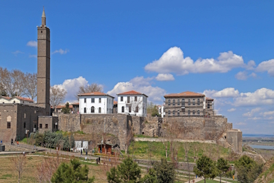
Its long history includes Roman, Byzantine, Umayyad, Artuqid, Seljuk and Ottoman periods. The Diyarbakır City Walls stretch for 5,800 metres with many towers, gates, buttresses and historic inscriptions.
Community Perspective: The site isn’t very well preserved, read Clyde and Stanislaw’s reviews for what ‘issues’ you may encounter. To appreciate the walls, you can do the extra-muros circuit where you’ll encounter some of the inscriptions (walking on the walls itself is hardly possible).

Map of Diyarbakir Fortress and Hevsel Gardens
Community Reviews
Zoe

This site covers a lot of ground and is hard to get a feel for on your own — just the walls of the city themselves are the 2nd widest and longest complete defensive walls (after only the Great Wall of China)! However, I found that visiting the Diyarbakir Archeology Museum first gave great contextualization for the rest of the city. Price is 3 euros for foreigners in Spring 2025.
Across from the museum, you can walk along a portion of the wall by climbing some steep stairs to reach the top. You can also get a view of the Hevsel gardens in the distance. This was a popular activity and you could see many young people taking pictures of the view. The WHS itself, without the museum, is left unexplained and the walls in particular have a lot of graffiti/vandalism. Walking along the walls, I found a lot of names etched in the bricks, spray paint, etc. Overall, I think the site has a ways to go in terms of restoration, as well as accessibility of information.
Nan

Arriving from Zerzevan South of town, I started my visit to Diyarbakir at the Ten-Eyed-Bridge. It's located a few kilometers down river from the old city and offers great initial views of the city. The walls sitting high on a hill look massive from afar and must have impressed any traveler (or army) arriving as I did from the South.
I continued my walk along the Tigris river. As mentioned by Stanislaw, you can't walk along the river, but have to follow the main road. Before entering the city at the Mardin gate, I briefly visited Hevsel Gardens. I get the idea of communal garden, but felt this would be better served as intangible heritage. There really is nothing historic to see and the local peasants were probably wondering what I was looking for.
After dropping my luggage at my hotel, I walked along most of the circumference of the walls. I was expecting being able to walk on the walls like in Lugo or Avila. This is only possible at some places. In comparison, I found both Avila as well as Lugo better preserved. And walking on the walls had me worried as there are no rails and the walls are not always in best shape. Highlight of the fortification are the Diyarbakır Fortress and the South Western corner.
The city itself offers more sites. To me the two best site were the Great Mosque and the ruin of the St. George Church. The Great Mosque itself was originally a Christian church (St Thomas). When you visit you can clearly see that this is a church nave layout.
Getting There
Being a big town, Diyarbakir has loads of bus and plane connections.
I came from Mardin via Zerzevan. Plan was to catch a dolmus, but I couldn't find the dolmus station in Mardin. It's not the otogar. The bit from Zerzevan to Diyarbakir I hitchhiked. I got off before we reached the town proper and walked to the Ten Eyed Bridge, only to get a second ride offered by another friendly Kurdish local.
I left by plane to Izmir. Cab to the airport fare was a joke.
And Clyde is right: You will pass plenty of checkpoints, so keep your passport within reach.
While You Are There
Zerzevan is a must. Mardin and Midyat will probably require staying a night. The next major town is Urfa, to me a must visit, too.
Clyde

I visited Diyarbakir in Spring 2021 after Sanliurfa and before heading towards Van lake and spent 2 nights and 3 days here. When planning my road trip loop I had marked this area as the one I was to be most careful in based on some rough experiences some travellers went through here. It's close proximity to conflict stricken countries such as Syria and Iraq, plus being the unofficial capital of Turkish Kurdistan, all seem to contribute enough to being a bit more careful in principle.
During our visit though, we encountered no problems whatsoever and the locals were really friendly and proud that two Western tourists made an extra effort to visit their city notwithstanding its reputation and the COVID-19 travel restrictions. Due to the COVID-19 travel restrictions imposed on most locals, such as the ban on inter-state travel, when we visited most if not all refugees or migrants from neighboring countries were either pushed back or living in tent communities in the fields on the outskirts of the city. Police and military forces are always on the alert here, so expect numerous checkpoints not only on the way to/from the city but also within different districts within the city walls. Together with the CCTV cameras installed literally everywhere, the city (especially inside the area inside and near the city walls) felt extra safe at all times.
The city walls have gone through constant turmoil or acts of vandalism, but the UNESCO inscription seems to have helped to protect and restore as much as possible all of the components of this site. The immediate areas on either side of the city walls are now green areas with playgrounds, and benches to sit down and relax while many locals are always roaming around night and day selling hot chai tea. Some of the city gates are still pretty much in the middle of main roads now, but most areas are being pedestrianised. Only very negative aspect I noticed is that a whole district of the city centre (southwestern area of Sur) has been recently (since the 2015-2017 Kurdish-Turkish conflict) closed off and turned into an administrative area with government buildings, sometimes only leaving a few facades of the several monuments that litter this extraordinary city at the crossroads of Turkey, Syria, Iraq and further east Iran and Armenia. The same wipeout operation is planned for the very poor district right outside the city walls near one of the main gates, which should help to get rid of the graffiti problem and the local goats left grazing about by the city walls. However, much of the living character will be lost this way in favour of a museum city, a problem experienced also in Shahrisabz in Uzbekistan.
This is a real pity as the city exudes history in every other building, and considering the fate of other ancient cities nearby such as Aleppo or Damascus, the unique monuments and ensemble have been preserved quite well despite the very recent troubles. The city walls come from the old Roman city of Amida and are the widest and longest "complete" defensive walls in the world after only the Great Wall of China. Even though they underwent a lot of restoration and reconstruction efforts to be maintained, 65 of the original 82 towers still remain on the outside of the city's walls and 18 of the citadel's towers remain today. The first thing we did upon arrival in the afternoon was to walk around the outside of the city's walls from , as we knew that walking on the city walls themselves or on the inside we would have missed out on some of the unique features of some of the towers which are best appreciated from outside towards sunset. The best ones to admire the Artukid symbols and Koranic inscriptions, together with nature reliefs are those of Nur, Yedi Kardes (top left photo) and Evli Beden. Another tower worth visiting is Keci Burcu or Goat Tower, mostly because of the former Zoroastrian sun temple underground. A peculiar feature of the city walls are a pair of heart-shaped stairs apparently leading to nowhere.
I sincerely had thought that the city walls together with the Hevsel gardens by the Tigris were the only highlight of this old city, but I was deeply mistaken. Inside the city walls, notwithstanding the current demolition of about a third of the citadel, there are interesting monuments everywhere and the city, with an overwhelming Kurdish majority, is very much alive especially during the calls for prayer. The easiest to cover the citadel is walking up and down both its central axis, Gazi Caddesi and Melik Ahmet/Yeni Kapi Caddesi. Close or right along these two main roads are mosques, madrasas, minarets, churches, bazaars, and the Hasan Pasha and Deliller/Husrev Pasha caravanserais (the latter is a perfect stop for a tea if not your actual base to visit the city). The heart of the citadel is definitely the Great Mosque of Diyarbakir (Ulu Cami; top right photo) which was inspired by the Great Mosque of Damascus in Syria. The Kufic inscriptions found on the exterior of the facades record in detail the rebuilding and additions made to the complex throughout its long history. Lavish carvings and decorations of the pillars and columns in the courtyard are one of the distinguishing features of the Great Mosque of Diyarbakir and are truly unique and in great condition (bottom right photo). Don't miss the El Cezeri sundial in the courtyard as well as all the other ingenious inventions by El Cezeri inside the mosque. The western arcade of the courtyard also includes the first use of the broken arch. Make sure to knock on the door on your right beneath the porticoes, just after entering the main courtyard. A friendly security guard opened and without speaking a common language except smiling at each other, he proudly showed me around the beautiful Mesudiye Madrasa which I had almost missed. The ornate decorations with influences from Syrian Islamic architecture are worth viewing.
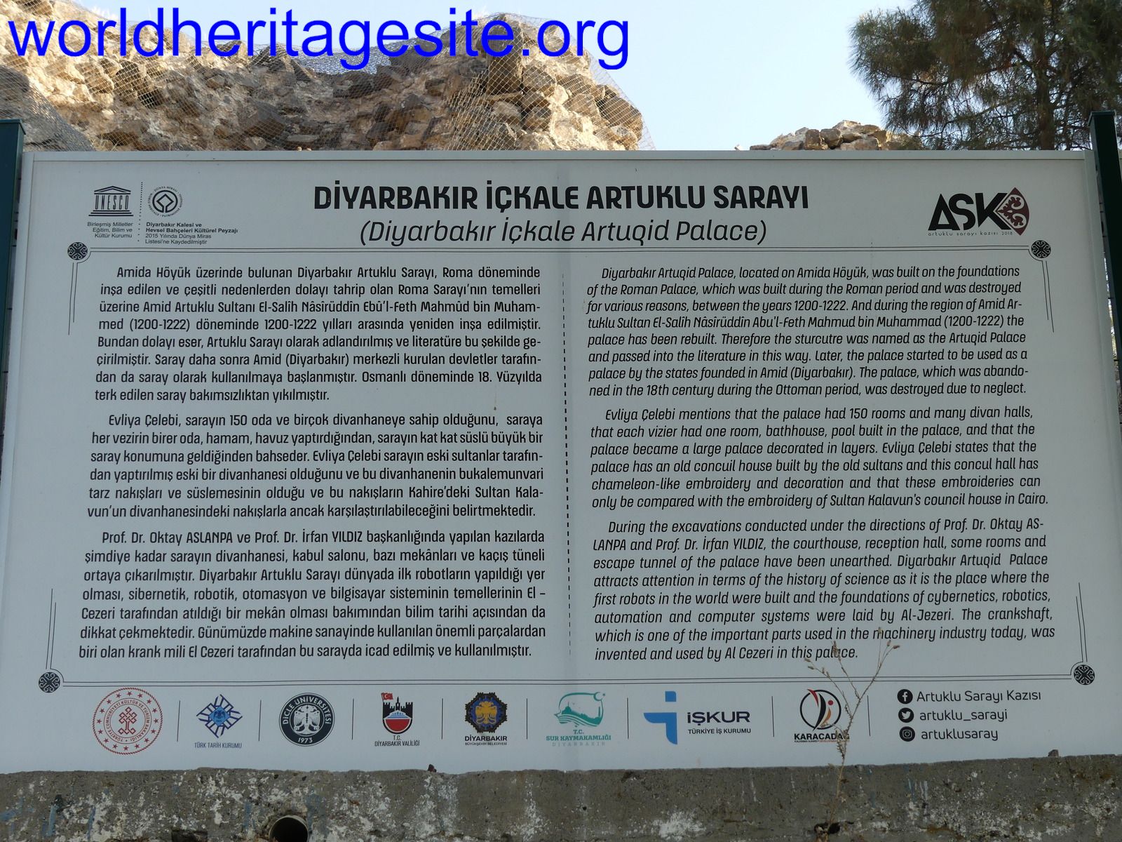
Within the city walls lies also the unique Seyh Muhtar four-legged minaret which was the site of a tragic political assassination. According to a story, the four columns or pillars represent four denominations of Sunni Islam and the minaret above represents the religion of Islam as a whole. A local belief says that any individual who passes seven times between the four columns will have all their wishes granted, not worth trying if your taller than six feet as you're only wish will be not bumping your head on the hard basalt rock! The best remains of an Armenian church are probably those of Surp Giragos Armenian Church which can only be seen from afar for the time being as the whole area around the church as well as the church itself were confiscated in 2016 under a controversial expropriation law. This is the area which has since been largely demolished or is in the process of being wiped out. By roaming around the metal scaffolding around this district, you'll easily be able to spot other interesting monuments which are the only buildings being restored in this area. The rest is being built from scratch. Obviously police presence is mostly around this area and to access the area close to Saray Gate, near the inscribed locations of Amida Mound and the water distribution system at the Artuk Palace devised by El Cezeri/Al Jazeri, I went through what looked like a pedestrian checkpoint. Access is given to tourists without any problem though. Unless your into the history of science and the invention of the first "robots" by El Cezeri, you can easily skip going inside this site. Just outside the city walls from here you can gaze at the 178 meter ten-arched Dicle Bridge (On Gozlu Kopru; bottom left photo) over the Tigris River as well as the 700 hectares of cultivated fertile land of the Hevsel Gardens. The area closest to the bridge to the Hevsel Gardens is a lovely place to hike at sunrise and at sunset but you won't find any alcohol (not even beer) for sale here as its not allowed at all!
I really enjoyed my time here and had I an extra day to spare I would have also visited nearby Mardin as it seems worthwhile too. An excellent take away I also discovered here (which can be found all over Turkey) is Bulent Borekcilik for some Borek cheese pastry. All in all another great WHS in Turkey, and hopefully UNESCO and ICOMOS manage to intervene to stop the ongoing demolition and preserve all of the old citadel of Diyarbakir.
Stanislaw Warwas

Visited April 2018. Diyarbakır is the unofficial capital of Turkish Kurdistan. The city is really big and still booming thanks to the GAP Project, but the part interesting for tourists is located on its eastern outskirts, closer to the Tigris River. The Kurdish people call the city Amida as it was named two thousand years ago.
I have very mixed feelings about this inscription that was put into WH List 2015 after ICOMOS referral. Surely it is not my favourite WHS in Turkey although I have to admit that the inscribed part has a kind of a charm… There are 6 components which constitute one rather big unity: Içkale with Amida Mound, City Walls, Hevsel Gardens, Ten-Eyed Bridge, Natural water resources, Tigris River Valley.
1. Tigris River Valley. It is hard to believe that this river (locally called Dicle) together with Euphrates gave birth to Mesopotamian civilization. Now Tigris is just a 30-meter wide, shallow and dirty. Only eastern bank of the river has a walkable path, the one on the citadel site is partially in the private hands so wired fences are not uncommon. 2. Natural water resources are the most difficult to find. Just west of the outer walls, between Urfa and Mardin gates, after a moment of wandering around and asking locals, you can see Anzele Spring. Now it looks like a small pool, some of it hidden in the tunnel. Children are playing around, 3. Ten-Eyed Bridge is located around 3 km south of the Mardin gate. The first bridge was built here in the 11th century but what we can see now it the result of many later reconstructions, the last one at the end of the last century. It looks nice and links both sides of the Tigris – but nothing interesting where to follow. During hot days lots of places open around the bridge where you can have some tea, coffee or local drink. (Forget about any alcohol! You won’t officially find it anywhere in this part of Turkey.) 4. Hevsel gardens – in my opinion the most valuable part of this cultural landscape but not the most enjoyable to look at – “throughout its millennia long history have been open to the benefit of the public instead of being allocated to the palace, the noble and aristocracy” (from the very short description in the city museum). They’ve been used to grow food for at least 8 millennia. Today they are nothing more than some grooves, meadows and still cultivated fields with some mulberry and poplar trees. (On the photo with city walls in the background.) 5. More than 5 km long City Walls with its many gates and 82 towers buttresses in different shapes and sizes. The oldest parts were built by Romans and you can still see a Latin inscription at one of the gates. Most of them are quiet intact, only two stretches were demolished in the 1930’s to make way for modern roads. At your own risk you can walk on them, the best part is from Urfa gate to Mardin gate. You can also make an extra-muros circuit and then you’ll have a chance to see most of the inscriptions belonging to Islamic period (don’t miss Ben u Sen and Yedi Kardes bastions). Coming from west, you’ll pass some poor neighbourhood where old houses are still stuck to the walls. Intra-muros circuit is not possible right now, because few years ago the government demolished the whole Armenian quarter to build “more traditional” houses (whatever it means). But at the southern entrance to this part of the city stands Goat Bastion, one of the biggest, where Zarathustra temple was located – you can have a look inside. Most of the towers and bastions that served as storages and arsenals are empty now. 6. Içkale with Amida Mound is the oldest part of the city and has its own walls. After the revitalisation that was made few years ago it looks like a city picnic spot. It is small, but divided in three parts: the picnic area, the museum are Amida mound which is not open for tourists. So if you’re there, see the museums: archaeological and city museum are recommended.
If you want to get some more info about the city, try in one of the two information centres. One of them is located in Dag Kapi Bastion and the other just behind it in kiosk on Dag Kapi square. In both you can grab some leaflets and maps. If you’re looking for a UNESCO WH sign, I could not find it anywhere around the property, but inside a local governmental institution that look after the cultural heritage of the city (it’s located to the right of the main entrance to Friday mosque, a place not to miss!) there’s a kind of diploma on the wall with the information that the city (?!) was inscribed (ask the guards to let you in).
If you’re staying longer than a day, you can make interesting day trips to see Nemrut Dagi (WHS) (only organized tours) or some places from Tentative list: Mardin and Deyrulzafaran Monastery, Malabadi Bridge, and even Gobekli Tepe and Sanliurfa.
Community Rating
- : Maciej Gil AYB
- : Ferhatdonmez Rafał Kałczuga
- : Alexander Lehmann Can SARICA Tarquinio_Superbo
- : Clyde Hanming
- : Wojciech Fedoruk Szucs Tamas Philipp Peterer Bin Philipp Leu GeorgeIng61 John Smaranda Afshin Iranpour Usagi1974 Tony0001 Bergecn
- : Walter Nan Adrian Turtschi Cluckily Kevin McFarland Zoe Yevhen Ivanovych
- : Zoë Sheng Dimitar Krastev Thomas van der Walt Solivagant Stanislaw Warwas Els Slots
Site Info
- Full Name
- Diyarbakir Fortress and Hevsel Gardens Cultural Landscape
- Unesco ID
- 1488
- Country
- Turkiye
- Inscribed
- 2015
- Type
- Cultural
- Criteria
-
4
- Categories
- Cultural Landscape - Continuing Structure - Military and Fortifications
- Link
- By ID
Site History
2015 Advisory Body overruled
ICOMOS advised Referral, Lebanon provided amendment for inscription
2015 Inscribed
Site Links
Unesco Website
Official Website
Related
In the News
Connections
The site has 23 connections
Constructions
Damaged
Geography
History
Human Activity
Individual People
Religion and Belief
Timeline
Trivia
WHS Hotspots
World Heritage Process
Visitors
93 Community Members have visited.
The Plaque
 (photo by Clyde)