Swiss Tectonic Arena Sardona
The Swiss Tectonic Arena Sardona is a significant example of the process of mountain building.
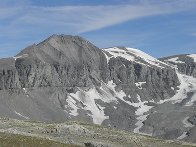
The Tectonic Arena contains a major break in the Earth's crust: the Glarus thrust. It is a clearly exposed and well-accessible example of thrust faults in general, and has as such played an important role in the development of geological knowledge on mountain building.
Community Perspective: To see the whole area you can hike from Elm to Flims – a tough hike of 21.5km if you do it in full (Nan can probably still feel his legs). Lazier people can (like Els did) go and reach the Fil de Cassons from Flims by chairlifts and a cable car ride, but Ralf recently has reported that this route is under construction until at least the end of 2024.

Map of Swiss Tectonic Arena Sardona
Community Reviews
Kbecq

Mid August we visited the Sardona region for a couple of days. As mentioned in the description, the area is most famous for the ‘Glarus thrust’ whereby older mountains are located on top of younger mountains because of movement of the earth's crust. Below some practical points with respect to the three hikes we did in and around the core zone.
Elm: from the small village of Elm, the Tschinglenbahn cable car goes to the Tschinglenalp where a relatively short and easy hike to the Firstboden viewpoint starts. Starting the hike from the lower end of the cable car is also possible. From the Firstboden viewpoint there is an excellent view on the Glarus thrust and the Martinsloch (cf. picture). A small parking is available at the cable car station and also one a couple of hundred meters down the road. The fee for the cable car is CHF 18 (return ride) and on the Tschinglenalp there is a place to eat and drink (Tschinglen Wirtschaft).
Wangs: the 5 lakes hike starts in Wangs with a cable car to Furt, a chairlift from Furt to Gaffia and another chairlift from Gaffia to Pizolhütte at 2.222 meters. The hike ends at the Gaffia chairlift so the way down is somewhat shorter. A combined return ticket will set you back CHF 98 (plus CHF 5 for the (large) parking). The hike is a good 11 kilometers with three steeper sections, a total ascent of approx. 600 metres. The total decrease in altitude is about 900 metres since as mentioned the hike is not a loop but ends at the lower Gaffia chairlift. Especially the turquoise second and third lakes (Wildsee and Schottensee) are a special sight. The time needed is about 4.30 - 5 hours and note that you have to be at the Gaffia chairlift at 16.30h at the latest.
Fidaz: the Pinut via ferrata (klettersteig) starts at the small Milchseilbahn parking (with a fee of CHF 2/hour) which can also be reached by bus from the larger village of Flims. We don’t know if it’s obligatory, but it’s certainly a good idea to bring a via ferrata climbing set (belt and helmet). We rented one in Flims at the Sport Beat shop. It’s a 1 kilometre walk through the forest before the rock is reached. After the first climb there are 2 other rock faces and steep forest paths in between. Once you have climbed the third rock it’s a short walk to the top where there is a small self catering hut with a fridge (so bring coins). From here it’s all downhill to Bargis where there is a place to eat and drink (Berghaus Bargis). The hike back from the Berghaus to the parking is 2.4 kilometres, bringing the total length to almost 8 kilometres. The total ascent and descent is approx. 900 metres. From the Berghaus it’s also possible to take a bus back to the parking. The climbs are easy, not really climbing but mostly ladders. The forest parts inbetween however are at some points quite steep. So technical climbing skills are certainly not required but a decent physical condition is.
Ralf Regele

I mainly want to give an update about the accessability of the WHS area. In Flims, the old cable cars are replaced by a new system called "Flims Express", which will serve the Foppa-Naraus-Fil de Cassons line. However, the new lift is not expected to be operational before the end of 2024, and the old cable cars are already out of service. This means that the cable car tour described in some of the other reviews is no longer available. You can still hike the Foppa-Fil de Cassons route, but this means hiking all the way up from Flims and down again. To at least get a a good view of the main "arena" area with the Tschingelhörner, I opted for the alternative route from Flims, which is going up by the second main cable car line "ArenaExpress" up to Nagens. The WHS area can't be seen from there, but there is a rather short (30min) hiking trail over the mountain hump to the end station of the "Grauberg" lift (which was also not running). From there, you have a pretty good view over the main arena area (see the picture). However, you are technically still only at the border of the core zone. To be sure, you have to go down the hiking trail to the "Untere Segnesboden", the lower plain below the Segnes pass. Although it was a nice sunny September day, the whole area was already covered in ice and snow. Considering my flimsy shoes and equipment, I hiked back to Nagens and had to be satisfied with the view alone.
So, the WHS area is currently hard to reach for none-hikers. However, I had a look at the maps and discovered that the core zone is much bigger than expected, expecially in the valley leading to Elm. There is a site called "Lochsite" where the core zone reaches down almost to the bottom of the valley, and there seems to be a geological trail there. Might be worth checking out if high altitude hiking isn't your cup of tea.
Visited in Spetember 2023.
Importance 3/5 Beauty 4/5 Uniqueness 3/5 Environment 5/5 Experience 3/5
Nan

In what was dubbed by some a mini meetup me and Philipp ventured into the Sardona Tectonic Area. It was a mostly sunny July day when we set out from Flims to cross the mountain range at the Pass dil Segnas and descent on the other side to Elm.
It all started with a bit of a misunderstanding. Philipp had send me a trail map of the 6th day of the world heritage trail. I took it to mean he wanted to do the full trail when his original intention was to do only a part of it. He didn't see the need to correct me on my misunderstanding. Or put in any effort to clarify what the Swiss mean when they categorize a trail as hard. So we did the full trail.
We met in Chur in the morning and took the bus to Flims. In Flims you can start the trail or catch a lift up into the mountains. There are multiple stops on different alitutde levels. We decided to go up to the first stop, Focca, from where we started our 8h, 19km, 1500m altitude difference (up and down) hike.
On the Flims side it's a fairly steady climb on good trails in a beautiful landscape. For parts of it we followed a mountain river. When we reached the upper plateau at Camona de Segnas it started to rain. Philipp hadn't bothered to bring a rain coat. And I noticed that I had forgotten mine in the hotel room in Chur.
The Camona di Segnas offers nice views of the different layers of mountain, the OUV feature of this area. You can clearly see the border between the different rock formations. For those not too enthusiastic about hiking, there is also the option to go by lift to the uppermost station. I am not sure though that you can see the Martin's Loch (hole) from here. I think you need to hike a bit up in the direction of the pass.
The last climb up from Camona di Segnas to the Pass dil Segnas got rougher, albeit it stopped raining. We crossed plenty of rock and snow fields with the last stretch to the pass especially challenging. But we made it and stood on the mountain pass.
From here we made our descent to Elm. The Elm side is steeper and there are essentially no even stretches to give you some relief. It's more or less a constant, strenuous descent.
In the end I must admit that I pushed past my limit. While I am happy that I made it down in one piece and we got some amazing views, my legs complained for the better part of the following week.
Philipp meanwhile was just smiling along. It seems being a great mountain guide is something the Swiss get with their passport.
Getting There
Both Elm and Flims are served by busses that connect you to the Swiss Rail network and the rest of Switzerland. From Elm you can take a lift for a minor part of the way up. From Flims you can take multiple lifts to reach the upper plateau at Camona da Segnas.
How to Visit
The area offers multiple hiking options that you can tailor to your needs. If you want to go all in, there is the aforementioned 6 day hiking trail, the heritage path. For daytrippers, Flims and Elm seem the best spots.
The Flims side to me is the easier ascent/descent option as it's not quite as steep and provides three different locations where you can opt for a lift ride up/down. The Elm side meanwhile only has a single lift that operates less frequently (on demand) and does not take you all that high up. However, from the end point you can see the famed Martin's Loch.
If you plan to follow our example and hike across the mountain range, I would probably opt for Flims to Elm as the Elm side is steeper. I am not sure I would have made it up on the Elm side. However, my knees were hurting a lot coming down, so maybe ascending on the Elm side would have been the smarter choice. Looking back we should have returned the same way we came, back to Flims.
In any case bring good shoe, sufficient water and be in reasonable shape. Looking at the weather forecast also is a must.
Clyde

I visited this WHS in June 2014. I based myself in Flims and already getting there by car made my trip worthwhile. About 100m from the tourist information centre, I bought my tickets to the Fil de Cassons. From Flims I went up to Foppa (1420m) by chairlift, up to Naraus (1843m) again by chairlift, and up to Cassonsgrat (2695m) by cable car. The return trip cost around 35 euros. At every stop there are information boards, a bar or restaurant, a panoramic viewpoint and toilets. I suggest taking your time to acclimitise at each stop to avoid any possible altitude sickness. The temperature difference from Flims to Cassons was around 18 degrees so wear layers and bring a good windjacket and good hiking boots. Once I arrived at Cassonsgrat, I hiked at the panoramic viewpoint with the UNESCO information boards and a clear view of the Tschingelhörner. From there I ventured on a strenuous hike on a trail called "Fuorcla Raschaglius" (30 minutes) and another trail called "Pass dil Segnas" (2.5hours). Although I visited in late June, it was quite cold and there was quite a lot of snow left. After spotting several marmots and alpine birds and flora, I found my way back to Cassons and down to Flims.
Els Slots

For my visit, I chose the approach from the south side. Two chairlifts and a cable car ride from the town of Flims brought me up on the Fil de Cassons, at the altitude of 2634m. This mountain ridge itself is part of the core zone of the WHS. The best thing however is the view of the surrounding mountains: no less than 555 Alpine peaks can be seen from here on a clear day. And although IUCN did not value the scenery as exceptionally beautiful, I found the 360-degree view pretty spectacular.
There's an easy hike at the ridge of the Cassons with displays to tell you all about the geology, flora and fauna. In preparation, I had tried to read the nomination file for this WHS, but it seems to have been drafted specifically for geology experts. It includes so many specific words that I did not really get a clue what it all is about. The only element that I can reproduce is that older rocks occur here on top of younger rocks, an effect created by the movement of the earth's crust. The different effects this has on the layout of the mountains can indeed be easily seen from here.
The area also is the starting point for several hikes. From Cassons I walked down to the lowest cable car station in Naraus. The path descends very steeply all the way. It is narrow, and loose stones and muddy stretches keep you on alert all the time. Including stops, it took me 2.5 hours to get down, an hour more than the hike is advertised. As I am writing this a day later, I can still feel the pain in my upper legs...
John booth

I visited the Sardona range from two sides. From the north by the bergbahn from Flims, accessed by postbus from Chur. The next day I approached from the south, by cable car from Elm, accessed by Postbus from Schwanden.
More of the tectonic area is visible from the south side.
Allison Vies
Switzerland/Peru - 16-Jul-10 -
The most impressive mountains of the Swiss Tectonic Arena Sardona are the Tschingelhörner. To go there I suggest you travel to Elm, a small picturesque village in the Glarus region. The village is easily reached by car. Otherwise take a bus from Glarus (the city) as there is no train. In Elm you will find a small funicular that brings you close to the mountains. To get a closer look the only way is to hike. There are (quiet expensive) 1 to 2 days guided tours on weekends that bring you close to the Tschingelhörner. To see the whole area you can hike from Elm to Flims. The trip takes about 6.5 hours and shouldn't be done by inexperienced mountain hikers.
Community Rating
- : Roman Raab Marty Max Yevhen Ivanovych
- : Gary Arndt GeorgeIng61 PabloNorte Christravelblog Can SARICA Philipp Peterer MoPython Jezza Ih0000 Dejulis@hotmail.com Hasco Els Slots
- : Alexander Lehmann Christoph Svein Elias Cezar Grozavu Randi Thomsen Jean Lecaillon Echwel Cobaltrage Jeanne OGrady Ralf Regele
- : Nan Craig Harder Shandos Cleaver Wojciech Fedoruk Daniel C-Hazard Frederik Dawson Daniel Gabi Tschibi Martina Rúčková
- : Maciej Gil Clyde Joyce van Soest David Berlanda Caspar Dechmann MaxHeAnouBen Deffra
- : Szucs Tamas Mikko Jakob Frenzel Dorejd Solivagant
- : Zoë Sheng Philipp Leu Ivan Rucek Argo WILLIAM RICH Mahuhe Dirk-pieter
Site Info
- Full Name
- The Swiss Tectonic Arena Sardona
- Unesco ID
- 1179
- Country
- Switzerland
- Inscribed
- 2008
- Type
- Natural
- Criteria
-
8
- Categories
- Natural landscape - Glaciation
- Link
- By ID
Site History
2008 Inscribed
2005 Requested by State Party to not be examined
As Glarus Overthrust
Site Links
Unesco Website
Official Website
Related
Connections
The site has 12 connections
Constructions
Damaged
Ecology
Geography
Timeline
WHS Hotspots
WHS on Other Lists
World Heritage Process
Visitors
146 Community Members have visited.
The Plaque
 (photo by Clyde)
.JPG) (external source)
(external source)