Geography Connections
All connections part of Geography.
| Connection | Description | Sites |
|---|---|---|
| Adriatic Sea | Sites located directly at the coasts of the Adriatic Sea (within 10km). The Adriatic Sea is a body of water separating the Italian Peninsula from the Balkan peninsula. See also http://www.sitiunescoadriatico.org/index.php?pg=30 |
14 |
| Aegean Sea | WHS located on the shores of the Aegean Sea. | 5 |
| Alps | 15 | |
| Amazon Basin | WHS that are located within the Amazon Basin, the part of South America drained by the Amazon River and its tributaries. It is limited to those in the Amazon watershed, not the more extensive Amazon biosphere. | 14 |
| Andes | WHS located within the Andes Mountains. | 23 |
| Antipodes points | WHS which are situated approximately (within 2 degrees of latitude and longitude) opposite each other on the globe. | 22 |
| Archipelagos | WHS which are archipelagos or consist of more than one island from within an larger archipelago. Archipelagos are groups of islands, often volcanic, forming along island arcs generated by subduction zones or hotspots, but there are many other processes involved in their construction, including erosion, deposition and land elevation. The main construction process is shown. | 22 |
| Arctic | Sites that are located north of the Arctic Circle. | 7 |
| Arctic Ocean | Sites bordering the Arctic Ocean. "Marginal seas" that have their own connection take precedence over the connection with the Arctic Ocean (elsewhere the Ocean is applied) |
5 |
| Atlantic Forest | The Atlantic Forest is a terrestrial Biome and region which extends along the Atlantic coast of Brazil from Rio Grande do Norte state in the north to Rio Grande do Sul state in the south, and inland as far as Paraguay and the Misiones Province of Argentina. (wiki) | 7 |
| Atlantic Ocean | WHS related to the Atlantic Ocean, where a. boundary of the core zone touches the Ocean coast (including the "tideway" of estuaries) OR b. OUV mentions the Atlantic Ocean "Marginal seas" that have their own connection take precedence over the connection with the Atlantic Ocean (elsewhere the Ocean is applied) |
54 |
| Atoll | An atoll is a coral island (or islands) that encircles a lagoon partially or completely. The connection includes "Raised Atolls" which are now solid/near solid islands or at least have lost their classic lagoon form. | 10 |
| Baltic Sea | Sites located directly at Baltic Sea coasts | 17 |
| Basque | The Basque Country is a greater region in the western Pyrenees that spans the border between France and Spain, on the Atlantic coast. | 4 |
| Bay of Biscay | WHS bordering the Bay of Biscay. | 7 |
| Black Sea | WHS located on the shores of the Black Sea. | 6 |
| Brahmaputra Basin | “The Brahmaputra River is known by four main, plus many “local”, names as it flows through its different countries: Yarlung Tsangpo in China/Tibet, Siang as it enters the Indian state of Arunachal Pradesh, Brahmaputra in the Assam Valley of India and the Jamuna in Bangladesh.” | 6 |
| Caldera | A caldera is a cauldron-like volcanic feature usually formed by the collapse of land following a volcanic eruption. | 9 |
| Canyons | A canyon or gorge is a deep valley between cliffs often carved from the landscape by a river. | 31 |
| Cape | In geography, a cape is a headland or promontory of large size extending into a body of water, usually the sea. | 15 |
| Caribbean Sea | WHS bordering the Caribbean Sea. | 17 |
| Carpathians | The Carpathians are a range of mountains forming an arc of roughly 1,500 km across Central and Eastern Europe. | 12 |
| Caspian Sea | Sites that reach or once reached the coast line of the Caspian Sea. | 4 |
| Caucasus | 13 | |
| Cirques | A cirque is an amphitheatre-like valley head, formed by erosion. Cirque must be named. | 19 |
| Colorado River Basin | WHS situated within the Colorado Basin | 4 |
| Congo River Basin | Sites located in the Congo River Basin, as per http://en.wikipedia.org/wiki/File:CongoLualaba_watershed_topo.png. | 9 |
| Contiguous National Sites | WHS which "abut" each other within the same country (ie excluding "Transnational" abutting sites which already have their own "connection"). Different from "Inscribed twice or more" because the 2 sites are exclusive from each other. | 16 |
| Contiguous separate sites across national boundaries | Contiguous WHS across national boundaries that are inscribed twice. | 14 |
| Coral Sea | The Coral Sea is a marginal sea off the north-east coast of Australia. | 3 |
| Crater Lakes | 5 | |
| Danube | Sites located along the river Danube. | 7 |
| Dark-sky preserve | A dark-sky preserve (DSP) is an area, usually surrounding a park or observatory, that restricts artificial light pollution. The purpose of a dark sky preserve is generally to promote astronomy. (wiki) | 13 |
| Deepest | WHS with the greatest water depth within their inscribed area. Over 1000m. | 6 |
| Dependent territories | 20 | |
| Desert Cultural Landscapes | Cultural WHS where the OUV derives from its desert location. Sites do not have to be Cultural Landscapes per se. | 11 |
| Dinaric Alps | 9 | |
| Disputed territories | 24 | |
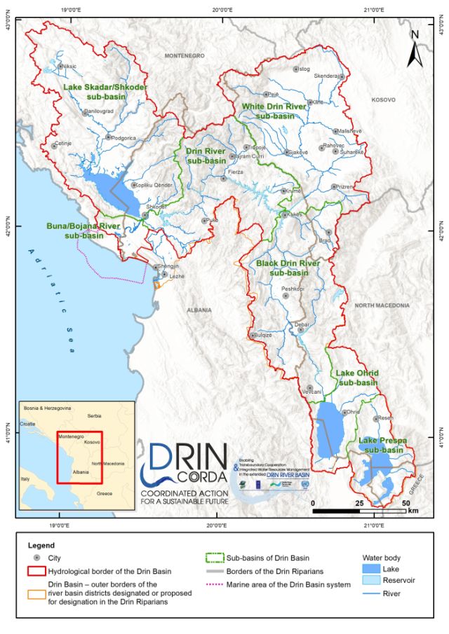
| Drin Basin | "The Drin is a river in Southeastern Europe with two major tributaries – the White Drin and the Black Drin and two distributaries – one discharging into the Adriatic Sea, in the Gulf of Drin and the other into the Buna River. Its catchment area extends across Albania, Kosovo, Serbia, Greece, Montenegro and North Macedonia... The river and its tributaries form the Gulf of Drin, an ocean basin that encompasses the northern Albanian Adriatic Sea Coast. At 285 kilometres long, the Drin is the longest river of Albania and its tributaries cross through both Kosovo and North Macedonia. Its northern tributary, the White Drin starts from the foothills of Žljeb, at White Drin Waterfall in west Kosovo, and flows generally south, whereas its southern tributary, the Black Drin originates from Ohrid lake in the town of Struga, North Macedonia and flows north." (wiki). See map. | 3 |
| East China Sea | WHS bordering the East China Sea. | 7 |
| Elbe Basin | 9 | |
| English Channel | Sites on the current or historic Channel coast or situated on its tidewater. | 6 |
| Equator | Located on the Equator. | 5 |
| Estuary | Sites that are situated in an estuary, comprise one or more estuaries or are meaningfully linked to an estuary. | 24 |
| Fjords | A fjord is a long, narrow inlet with steep sides, created in a valley carved by glacial activity. | 10 |
| Former Islands | WHS which, within historical memory, (rather than in the timescales of "Geological eras"!) used to be islands but are now not separated from the surrounding land | 11 |
| Formerly inhabited islands | Islands or island groups where the entire site is currently uninhabited but formerly at least some parts were inhabited. | 13 |
| Full White Nights | WHS where "Full White Nights" can be experienced. The 60°34' (60.34°) latitude cutoff is roughly the southern limit where astronomical twilight lasts all night during the summer solstice. At this latitude and northward, the Sun never dips more than 18° below the horizon around the summer solstice. This means true night never occurs, as the sky remains in at least astronomical twilight (the faintest level of twilight). Locations above this latitude experience White Nights or even the Midnight Sun, depending on how far north they are. | 33 |
| Gambia River Basin | The Gambia River " is a major river in West Africa, running 1,120 kilometres (700 mi) from the Fouta Djallon plateau in north Guinea westward through Senegal and The Gambia to the Atlantic Ocean at the city of Banjul. It is navigable for about half that length" (Wiki) https://en.wikipedia.org/wiki/Gambia_River#/media/File:Gambiarivermap.png | 4 |
| Ganges Basin | WHS on the banks of the Ganges or a river within its Watershed. | 11 |
| Geysers | 6 | |
| Glaciers | WHS currently (or at the date of inscription) containing Glaciers. | 47 |
| Guadalquivir River | WHS located along the general course of the river and / or have a cultural connection with it | 5 |
| Gulf of Bothnia | 3 | |
| Gulf of California | 3 | |
| Gulf of Mexico | WHS bordering the Gulf of Mexico | 4 |
| Highest (over 5000m) | 8 | |
| Highest cultural WHS | Cultural WHS (or the cultural parts of mixed WHS) that are located over 2,500 meter above sea level | 20 |
| Himalaya | WHS located in the Himalaya proper, the rugged arc between the Tibetan Plateau and the Ganges Plain. Including sites that are in its foothills or where the site lays claim to specific Himalayan features for its OUV. See also this map. |
12 |
| Hot Springs | 19 | |
| In former GDR | 16 | |
| Indian Ocean | Sites bordering the Indian Ocean. "Marginal seas" that have their own connection take precedence over the connection with the Indian Ocean (elsewhere the Ocean is applied) |
27 |
| Indus Basin | “Covers an area of 1,120,000 km2 (430,000 sq mi) traversing four countries: Afghanistan, China, India, and Pakistan, with most of the area lying predominantly in the latter. Geography The Indus River has two main tributaries: the Panjnad—formed by successive confluences of Sutlej, Beas, Ravi, Jhelum, and Chenab Rivers—and the Kabul, containing the waters of the Swat and Kunar Rivers, as well as others. The Indus and Sutlej originate on the Tibetan Plateau, the Ravi, Beas, Chenab and Jhelum originate in the Indian western Himalayas, and the Kabul and its tributaries originate in the Hindu Kush of eastern Afghanistan and northern Pakistan” (Wiki) see map | 7 |
| Isolated WHS | WHS without another WHS within range of 1000kms | 18 |
| Isostatic Rebound | WHS showing significant and visible signs of Isostatic ("Post Glacial") Rebound. | 9 |
| Isthmo Colombian Area | The Isthmo-Colombian (or Intermediate) Area is defined as a cultural area encompassing those territories occupied predominantly by speakers of the Chibchan languages at the time of European contact. It includes portions of eastern Honduras, Caribbean Nicaragua, Costa Rica, Panama, and northern Colombia. | 3 |
| Kings Highway | A trade route of the Ancient Middle East. It begun in Egypt at Heliopolis, crossed the Sinai to Aqaba, turned north to Damascus and finished at Resafa at the Euphrates. Parts were rebuilt by the Romans as the "Via Traiana Nova" and it figured in Christian and Moslem pilgrimage routes. Mentioned in the Old Testament - Numbers 20 17-21. http://en.wikipedia.org/wiki/King%27s_Highway_(Ancient) |
4 |
| Kurdistan | Kurdistan is a geo-cultural region wherein the Kurdish people form a prominent majority population. It consists of parts of Turkey, Iraq, Iran and Syria. | 9 |
| Lakes located in Rift Valleys | 7 | |
| Lapland | 3 | |
| Largest area | WHS with the greatest inscribed surface area (Excluding Buffer Zones but including marine areas) - over 100,000 sq kms. | 5 |
| Linear inscriptions | Cultural WHS whose core property is in linear form which has a "a start and end point, a considerable length and limited width". The linear aspects are man made, such as canals, roads/routes, railways etc This type of site became recognised within the operational guidelines as a "Linear Cultural Landscape" from around 1995 - "The possibility of designating long linear areas which represent culturally significant transport and communication networks should not be excluded." . However, not all "Cultural Routes" are inscribed "Linearly" (see http://www.esicomos.org/nueva_carpeta/CIIC_ingl.htm ) and sometimes it is not absolutely clear whether the finally inscribed site is "linear" or "point". Where a site is inscribed primarily in "point" form but also contains some linear stretches within an overall linear concept it is included. Where there is uncertainty the words used in the Nomination file/AB Evaluation are adopted. Excluding sites which, inter alia, merely contain such a network within a wider inscription (e.g Kii Mountains) or include a lot of areas some distance away from the line. |
53 |
| Located at an 'extreme point' of Latitude or Longitude | WHS whose boundaries include the Northern/Southern/Eastern or Westernmost points of the State Party nominating it. Excluding separate "Dependent Territories" and "rocks", reefs etc . See http://en.wikipedia.org/wiki/Extreme_points_of_Earth | 7 |
| Located in a Capital City | 96 | |
| Located in a microstate | A microstate is a sovereign state having a very small population or very small land area, but usually both. The connection is restricted to sovereign states with an area less than 1000 km2 and fewer than a million people. | 18 |
| Lowest (below sea level) | Sites with parts below mean sea level (not counting mines/tunnels etc). | 7 |
| Maars | A maar is a broad, low-relief volcanic crater that is caused by a phreatomagmatic eruption, which is an explosion caused by groundwater coming into contact with hot lava or magma. A maar characteristically fills with water to form a relatively shallow crater lake. (wiki) | 4 |
| Macaronesia | Macaronesia is the collective name for several groups of islands in the North Atlantic Ocean near Europe and North Africa: Azores (Portugal), Canary Islands (Spain), Cape Verde (Cape Verde), Madeira, including Desertas Islands (Portugal), Savage Islands (Portugal). The name Macronesia comes from the Greek for "fortunate islands", a term used by Ancient Greek geographers for islands to the west of the Straits of Gibraltar. The islands of Macaronesia are volcanic in origin, and are thought to be the product of several geologic hotspots. |
8 |
| Manchuria | Historical region, now Northeast China (Heilongjiang, Jilin and Liaoning) and part of northeastern Inner Mongolia | 4 |
| Marine sites | Sites which are predominantly "marine" - defined as the marine (M) area being greater than the terrestrial (T) area of the site. | 23 |
| Mediterranean shore | Sites currently or historically located on the shores of the Mediterranean Sea. Excluding sites located in the following "marginal seas" of the Mediterranean which have their own Connection - Adriatic Sea, Aegean Sea, Black Sea, Tyrhennian Sea. | 37 |
| Mekong Basin | WHS located on the Mekong River or its watershed. The Mekong River is one of the major rivers in the world. From the Tibetan Plateau it runs through Yunnan province (China), Burma, Thailand, Laos, Cambodia and Vietnam. | 5 |
| Melanesia | A subregion of Oceania extending from the western end of the Pacific Ocean to the Arafura Sea, and eastward to Fiji. The region comprises most of the islands immediately north and northeast of Australia. | 6 |
| Micronesia | Micronesia is a subregion of Oceania, comprising thousands of small islands in the western Pacific Ocean. | 4 |
| Mid-Atlantic Ridge | The Mid-Atlantic Ridge is a mostly underwater mountain range in the Atlantic Ocean. See more at http://whc.unesco.org/en/activities/504/ |
6 |
| Mississippi Basin | also referred to as the Western Rivers, is a mostly riverine network of the United States which includes the Mississippi River and connecting waterways. The Mississippi River is the largest drainage basin in the United States. In the United States, the Mississippi drains about 41% of the country's rivers...The major tributaries are the Arkansas, Illinois, Missouri, Ohio and Red rivers. Given their flow volumes, major Ohio River tributaries like the Allegheny, Tennessee, and Wabash rivers are considered important tributaries to the Mississippi system. Before the Mississippi River reaches the Gulf of Mexico, it runs into its distributary, the Atchafalaya River.” (Wiki). see map | 8 |
| New islands | New islands are islands which have been created recently (since 20th century), whether by means of volcanism, erosion, glacial retreat, or other mechanisms. | 3 |
| Niger Basin | The Niger River is the main river of West Africa, extending about 4,180 kilometres (2,600 miles). Its drainage basin is 2,117,700 km2 (817,600 sq mi) in area. Its source is in the Guinea Highlands in south-eastern Guinea near the Sierra Leone border. It runs in a crescent shape through Mali, Niger, on the border with Benin and then through Nigeria, discharging through a massive delta, known as the Niger Delta, into the Gulf of Guinea in the Atlantic Ocean. The Niger is the third-longest river in Africa, exceeded by the Nile and the Congo River. Its main tributary is the Benue River.” (Wiki) See map | 5 |
| Nile | Sites along the river Nile. | 7 |
| North Sea | Sites on the current or historic North Sea coast or situated on its tidewaters. | 11 |
| Notable lakes | Sites including notable lakes, or on the banks thereof. | 27 |
| Offshore of a major city | WHS which are situated on an island situated offshore from a major city. Must be possible to reach by ferry from the major city. | 9 |
| On a Continental Border | 5 | |
| On National Border | WHS that are located on national borders (but are not transboundary). "Nation" here refers to one of the 203 sovereign states as named in List of Sovereign States. | 58 |
| Pacific Ocean | WHS related to the Pacific Ocean, where a. boundary of the core zone touches the Ocean coast (including the "tideway" of estuaries) OR b. OUV mentions the Pacific Ocean "Marginal seas" that have their own connection take precedence over the connection with the Pacific Ocean (elsewhere the Ocean is applied) |
50 |
| Pacific Ring of Fire | The Pacific Ring of Fire is an area where large numbers of earthquakes and volcanic eruptions occur in the basin of the Pacific Ocean. | 11 |
| Pan-American Highway | WHS located along the Pan-American Highway. | 18 |
| Patagonia | Patagonia is a geographic region containing the southernmost portion of South America. | 5 |
| Peninsula | WHS which completely or significantly (>50%) occupy a peninsula, or are specifically linked to one. | 6 |
| Persian Gulf | WHS bordering the Persian Gulf | 4 |
| Polynesia | WHS within the geographical area defined as "Polynesia" and/or including Polynesian archaeological remains | 11 |
| Pyrenees | 7 | |
| Recently Active Volcanoes | A volcano which has erupted Lava, pyroclastic material or gases as a significant event in the Twentieth Century. With date of last eruption. Fumaroles, mud pots, hot springs and other continuing "minor" geothermal "extrusions" are excluded. "Decade Volcanoes" are 16 which have been identified by the International association of Volcanology and chemistery of the Earth's Interior (IAVCEI) as being worthy of particular study in light of their history of large, destructive eruptions and proximity to populated areas. |
18 |
| Rhine | Sites located along the river Rhine. | 8 |
| Rhone | Sites located along the river Rhone | 6 |
| Río de la Plata Basin | “the 3,170,000-square-kilometre hydrographical area in South America that drains to the Río de la Plata. It includes areas of southeastern Bolivia, southern and central Brazil, the entire country of Paraguay, most of Uruguay, and northern Argentina. Making up about one fourth of the continent's surface, it is the second largest drainage basin in South America (after the Amazon basin) and one of the largest in the world. The main rivers of the La Plata basin are the Paraná River, the Paraguay River (the Paraná's main tributary), and the Uruguay River.“ (Wiki) See map | 7 |
| River deltas | 28 | |
| Roof of the World | Roof of the World is a metaphoric description of the highest region in the world, also known as "High Asia", the mountainous interior of Asia. The term is also used for parts of this region, for - the Pamirs, - the Himalayas - Tibet - Mt. Everest The name was first applied to the Pamirs. (wiki) |
7 |
| Sahara | 15 | |
| Sahel | The Sahel is the ecoclimatic and biogeographic zone of transition between the Sahara desert in the North and the Sudanian savannas in the south. | 15 |
| Scheldt | WHS located along the river Scheldt (within 500m) or one of its tributaries. | 5 |
| Sea of Japan | The Sea of Japan is a marginal sea of the western Pacific Ocean, between the Asian mainland, the Japanese archipelago and Sakhalin. A controversy exists about the sea name, with South Korea promoting the appellation East Sea. Each property is either located directly on or within sight of the coast. | 6 |
| Seamount | A seamount is a mountain rising from the ocean seafloor that does not reach to the water's surface (sea level), and thus is not an island. These are typically formed from extinct volcanoes, that rise abruptly. | 3 |
| Siberia | Geographic region of Siberia | 5 |
| Situated in one of the SIDS | In Jun 1992 the UN Conference on Environment and Development recognised a distinct group of developing countries which it termed "Small Island Developing States (SIDS). In 1994 the "Barbados Program of Action" was produced to assist such countries in their sustainable development efforts. Currently the UN Department of Economic and Social Affairs lists 52 such states. Some of these are "Territories" or otherwise not full UNESCO members. For current list see https://www.un.org/ohrlls/content/list-sids The 2005 Durban WHC adopted a "World Heritage Program for SIDS which "coordinates and develops World Heritage activities on islands of the Caribbean Sea and the Atlantic, Indian and Pacific Oceans". See http://whc.unesco.org/en/activities/42. |
41 |
| Situated on a Continental Divide | A continental divide is a drainage divide on a continent such that the drainage basin on one side of the divide feeds into one ocean or sea, and the basin on the other side either feeds into a different ocean or sea, or else is endoorheic, not connected to the open sea. (wiki) | 11 |
| South China Sea | WHS bordering the South China Sea. | 7 |
| Southernmost | The 5 Southernmost WHS. | 5 |
| Straits | A strait is a narrow, typically navigable waterway that connects two larger, navigable bodies of water. | 15 |
| Subantarctic | WHS located in the Subantarctic, " immediately north of the Antarctic region. This translates roughly to a latitude of between 46° and 60° south of the Equator" (wiki) | 6 |
| Submerged continent | WHS located on a Submerged continent. | 8 |
| Swahili culture | Swahili culture is the culture of the Swahili people inhabiting the Swahili Coast. This littoral area encompasses Tanzania, Kenya, Uganda and Mozambique, as well as the adjacent islands of Zanzibar and Comoros and some parts of the Democratic Republic of Congo. (wiki) | 6 |
| Tagus | Sites located along the river Tagus | 3 |
| Territorial Highest points | Inscribed sites which contain the highest point within the jurisdiction of the "State Party" (and thus within its ability to nominate). This includes therefore such points in territories or autonomous zones where these are higher than the highest point in the "main unit" of the country. In some cases exact heights vary in different sources. For more info see: Peakbagger and Wikipedia list of countries by highest point |
30 |
| Tigris - Euphrates Basin | “The Tigris–Euphrates river system is a large river system in Western Asia that flows into the Persian Gulf. Its primary rivers are the Tigris and Euphrates, along with smaller tributaries…..the two rivers descend through valleys and gorges to the uplands of Syria and northern Iraq and then to the alluvial plain of central Iraq. Other tributaries join the Tigris from sources in the Zagros Mountains to the east. The rivers flow in a south-easterly direction through the central plain and combine at Al-Qurnah to form the Shatt al-Arab and discharge into the Persian Gulf. The rivers and their tributaries drain an area of 879,790 square kilometres (339,690 sq mi) including almost the entire area of Iraq as well as portions of Turkey, Syria, Iran and Kuwait” (Wiki) Nb. The Karun River, the largest river by discharge in Iran, flows from the Zagros Mountains and joins the Shatt al-Arab separately, downstream of the confluence of the Tigris and Euphrates and is therefore NOT regarded as part of the combined basin. It has been given its own Basin” connection. see map | 13 |
| Type of volcanic eruptions | WHS or parts thereof that have had a type of volcanic eruption named after it. | 4 |
| Tyrhennian Sea | WHS currently or historically located on the shores of the Tyrhennian Sea. For boundaries of the Sea - https://en.wikipedia.org/wiki/Tyrrhenian_Sea | 5 |
| Under control of ISIS | WHS that are (or have been) under control of the so-called Islamic State of Iraq and Syria (ISIS). | 4 |
| Uninhabited islands | Sites that are islands or island groups, without permanent population on the entire site (except for the odd scientist or park ranger). | 16 |
| Vistula | The Vistula is the longest river in Poland. | 6 |
| Volcanic Cone | Volcanic cones are among the simplest volcanic formations. They are built by ejecta from a volcanic vent, piling up around the vent in the shape of a cone with a central crater. | 10 |
| Volcanic plugs | A volcanic plug is a volcanic landform created when magma hardens within a vent on an active volcano. | 12 |
| Volga Basin | WHS situated along the Volga or in its basin. | 9 |
| Volta Basin | The Volta River is the main river system in the West African country of Ghana. It flows south into Ghana from the Bobo-Dioulasso highlands of Burkina Faso.......One of its smaller tributaries, the Oti River, enters Ghana from Togo in the east." (Wiki) See map | 4 |
| World's Highest Topographically isolated summits | 4. World's Highest Topographically isolated summits WHS containing one of the World's 40 most isolated summits. (Isolation in kms/Ht in m) "The topographic isolation of a summit is the Great Circle distance to the nearest point of equal elevation. Topographic isolation represents a radius of dominance in which the summit is the highest point." (Wiki). See here. Isolation Map - link. |
10 |
| World's most prominent mountains | WHS containing one of the world's 40 most "Prominent" mountains. "In topography, prominence, also known as autonomous height, relative height, shoulder drop (in North America), or prime factor (in Europe), categorizes the height of the mountain's.. summit by the elevation between it and the lowest contour line encircling it and no higher summit. It is a measure of the independence of a summit" and "The prominence of a peak is the minimum height of climb to the summit on any route from a higher peak...The lowest point on that route is the col." (Wiki). Showing a. the "Prominence height" above the "col". Prominence Height = height above the relevant contour or Mean Sea Level (MSL) if the nearest higher peak is not on same land mass. b. The "Col" height used c. The "Parent Peak" used For a discussion on meanings and alternative definitions of "Prominence", "Parent Peak" etc see http://en.wikipedia.org/wiki/Topographic_prominence. Prominence Map - link |
18 |
| Yangtze Basin | “The Yangtze (pinyin: Cháng Jiāng; lit. 'long river') is the longest river in Eurasia and the third-longest in the world. It rises at Jari Hill in the Tanggula Mountains of the Tibetan Plateau and flows 6,300 km (3,915 mi) in a generally easterly direction to the East China Sea. It is the fifth-largest primary river by discharge volume in the world. Its drainage basin comprises one-fifth of the land area of China, and is home to nearly one-third of the country's population” (Wiki). See map | 13 |
| Yellow River Basin | “The Yellow River, also known as Huanghe, is the second-longest river in China and the sixth-longest river system on Earth, with an estimated length of 5,464 km (3,395 mi) and a watershed of 795,000 km2 (307,000 sq mi).” (Wiki) See map | 6 |
| Yellow Sea | WHS bordering the Yellow Sea. | 3 |
| Yenisei Basin | The Yenisei is the fifth-longest river system in the world, and the largest to drain into the Arctic Ocean. Rising in Mungaragiyn-gol in Mongolia, it follows a northerly course through Lake Baikal and the Krasnoyarsk Dam before draining into the Yenisey Gulf in the Kara Sea. The Yenisey divides the Western Siberian Plain in the west from the Central Siberian Plateau to the east” (Wiki). The Putorana Plateau is a sub-plateau of the Central Siberian Plateau.see map | 4 |
| Zambezi basin | 4 |