Tajik National Park
Tajik National Park (Mountains of the Pamirs) is a very high mountainous and glacial landscape of spectacular beauty.
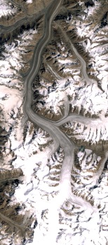
It lies at the center of the 'Pamir knot' where tectonic forces have pushed up the Himalaya, Karakoram, Hindu Kush, Kunlun and Tien Shan mountain ranges. Notable areas include the Fedchenko Glacier, the longest valley glacier outside of the Polar Regions, Sarez Lake, the largest freshwater lake in Central Asia, created by an earthquake-generated landslide, Karakul Lake, one of the highest salt lakes in the world and formed after a meteorite impact. Ismoil Somoni Peak (formerly known as Stalin Peak and Communism Peak), at 7,495 m high the highest peak in the Pamirs.
Community Perspective: all reviewers so far visited as part of a multi-day and permit-required trip along the Pamir Highway from Osh in Kyrgyzstan to Tajikistan, which includes a stop at Lake Karakul.
Map of Tajik National Park
Community Reviews
Walter

This propriety covers more than 2.5 million hectares in the east of Tajikistan, about 18% of the national territory, at the center of the so-called “Pamir Knot”, a meeting point of the highest mountain ranges on the Eurasian continent. It consists of high plateaux in the east and, to the west, rugged peaks, some of them over 7,000 meters high.
Visit to this propriety is difficult, because it is the remotest part of Tajikistan. Even if independent travel is possible, I would recommend to travel with a local guide or through a guided tour. The roads are very bad (meaning several punctured tires) and slow, and amenities are few (petrol, shops) even if guesthouses are plentiful. Additional to the Tajikistan visa (available as e-visa for most nationalities), a GBAO (Gorno-Badakhahan Autonomous Oblast) permit is needed, is available for an extra fee when applying for the e-visa, and will be checked several times on the way.
The entire Tajik National Park (TNP) was nominated for inclusion into the World Heritage, without need for a buffer zone (according to the IUCN technical evaluation). The propriety map is however confusing, with a division between a “core”, a “traditional use”, a “limited economic use “and a “recreation” zone. As far as I understand, the entire Park is a core zone according to usual WHS definition.
I travelled in a guided tour around the Pamir Highway in June 2019. We passed through the north-easternmost part of the park. We entered it at the Kyrghiz-Tajik border, a 4336-meter-high pass. The remoteness of this area is immediately felt. Villages are few, small and far-between. Driving time from Dushambe is about two days, and people tend to go to Osh in Kyrghistan for shops (still a 5 hours drive). I agree with Anthony Sun’s review stating a surreal landscape. No trees, grey pasture, snow covered mountains. The North-east area’s main feature is the salty Karakol lake, lying at 3960 meter in altitude, 52 km in diameter. The rugged peaks are visible on the other side of the lake. It is an impact crater, creating an endorheic (without an outlet) lake. Next to the lake if the very small village of Karakol, inhabited by ethnic Kirghiz, where we had a basic lunch. We left the park soon after by 4654-meter-high pass, on the way to Murghab.
The park features rare animals, like the Marco Polo sheep, snow leopards and Siberian ibex. However, their viewing is very rare, and we only saw a few domestic yaks, some fat marmots along the road and a few birds around the lake.
I only saw a very small portion of the site, and but can imagine how great the rest is. Worth the very long trip, and definitely of OUV.
Stanislaw Warwas

Site visited in May 2008, a pretty long time ago, so probably many things have changed and the access to the park could be easier than it was before. I was only in the eastern part of the park. At that time a special permission was needed to enter Gorno-Badakhshan Autonomous Region; this was issued together with the Tajik visa at the embassy in Brussels for an extra fee.
After spending few days in Khorog and around, we continued to Alichur where the road to the southern lakes (Yashikul) starts. We have not planned anything before and arranged the transportation in a homestay in the village. It took one long day to go to the lakes and back – of course there are only rough roads there but the pickup we rented with the driver was very brave! It was pretty cold and still some snow around.
After that we went on to Murgab – there are many interesting places about this provincial capital but it is located outside the park itself. We’ve chosen two day trip towards Sarez but after few hours of driving the car broke up and we had to walk to the nomad camp for 5 hours. It was a pretty nice and exhausting experience – to be lost somewhere in the middle of nowhere. We stayed there 2 nights ‘cos our driver and guide (one person) took a horse from the camp to get back to Murgab for a new car. We have not reached the lake…
The third time we crossed NP border was on the way to Kyrgyzstan. We stopped for one night at the Karakul Lake. Our accommodation – military base.
From every place in this part of Tajikistan the views are amazing! But you should be very patient! There were organized trips/tours to Pamir even from Murgab where they had a professional tourist agency, but very expensive. Organizing everything by yourself with local people takes time and could be risky but in our case turned out to be funny and rewarding!
Anthony Sun
In 1997, I was fortunate to go on a trip through the Silk Road which culminated on traversing the Karakorum Highway which starts at Kashgar in Xinjiang Province of China and ends in Peshawar, Pakistan. Along the way it passes the Pamir Mountains, Hindu Kush and Hunza. The Karakorum Highway was a feat of engineering and was built by the Chinese when they wanted a link with Pakistan to show solidarity against their then mutual enemy, India. Nonetheless, it was a project that cost many lives as the road was literally carved out of the mountain. The Khunjerab pass into Pakistan was at 4700m and all the while the highway would be at 4000m or more. Totally lifeless and yet spectacularly beautiful with snow cap peaks at >7800m all around. After every couple of hours on the road, you would see no other cars but an occasional cyclist/backpacker (always wondered why?)
Fast forward to September 2016 and the Karakorum Highway is now too dangerous a journey and still yearning for one last chance to savor the moment of total isolation and beauty once more and the Pamir Highway is beckoning at me from my atlas. It runs parallel to the Karakorum Highway for about a third of the way in Tajikistan and as a bonus, it runs through the Tajikistan National Park (WHS).
I go into full gear to make it and here are a litany of obstacles to consider. First of all, its not a convenient place to get to. Most travellers consider this a trekking destination and plan for a duration of several weeks. Since Mrs. Sun and I are not trekkers, we are looking for a shorter, more comfortable way.
The road from the Capital of Tajikistan, Dushanbe to Khorug and then to Murghab is nearly 1000km over very bad roads. I was told that either by your own 4WD or via shared taxis, it would take 3-5 days each way depending on weather and road conditions! From Murghab, its another 400+km to Osh across the Kyrgzstan. This is the section that goes through the core zone of the WHS, including Lake Karakul.
The other option which we chose was to come from Kyrgyzstan and cross the border into Tajikistan from the north. Even this will require 3 days to make this trip.
The first day was spent driving 4 hours from Osh to Sary Tash in Kyrgyzstan. Sary Tash is a desolate frontier town whose only value is that the roads from Kashgar, China come over the border through Sary Tash. There are no hotels here and the best we could do was a home stay in a farm house for two nights. The rooms are clean enough except that there is no running water and the toilets are an out house, with a hole, 20m to the rear of the building. Even in September, the temperature drops to below zero at night and no one contemplates making an evening visit to the loo. As such after a lot of hand waving, I managed to secure a bucket for our room.
Dinner was served in candlelight (electricity is intermittent) and consists of boiled potatoes and a piece of chicken. The second night it was just boiled potatoes. Mrs. Sun was rather unhappy as she did not shower nor go to the outhouse the duration we were there.
Also Sary Tash is at 3,200m and during the day we will pass 4,300m so we are popping diuretics.
From Sary Tash, its an hour drive to the border with Tajikistan over very bad roads and 4WD is highly recommended. There are shared taxis that ply the route from Osh to Murghab but I should caution that they run very infrequently, the border crossings are difficult and rudimentary Russian is a must to get anywhere.
In addition to getting a Tajikistan visa, you need to get a special GBAO (Gorno Badakhshan Autonomous Oblast) permit to travel here.
During the frontier crossings, I saw lots of cash change hands including a bottle of vodka.
Once you are in Tajikistan, the road becomes gravel and there are points where the roads are washed out with 8 foot drops. You just drive off the road, cross the low water stream and back up again. Its two or so hours before you arrive at the forsaken village of Karakul (not to be mistaken for the huge Karakul lake in Kyrgyzstan). This village started out as an outpost for the soviets to watch their border with China. Since independence for Tajikistan, the Russians are gone together with electricity and all other services. I am amazed anyone survives up here.
The landscape here and during the drive is surreal. There is no vegetation at all and the mountains are brown and grey. Snow caps are everywhere and the desolateness is captivating. Then there is Karakul Lake. It’s a dead salt lake that shimmers in the high UV light and looks out of place. There are some salt tolerant grass near the shore and that’s about it. No fish, no birds, (maybe the birds are gone for the winter) nothing.
At nearly 4000m, it’s the highest lake in Central Asia and apparently was caused by a meteor 10 million years ago.
Many travellers have been by including Xuan Zang, the Chinese pilgrim in his Journey to the West in 642 and he referred it as Dragon Lake. Also Marco Polo was reputed to have been by.
We stopped for lunch in a homestay and it is the only place in town as other visitors dropped by (4 Austrain men, 1 Alaskan woman) all with their guides.
After lunch we had a pleasant walk along the lake but as the wind whips up, it was way too cold.
To cap a very long day, we crossed back the border to Sary Tash.
Is this worth it? Definitely OUV compared to some of the new nominations. I am not sure I appreciate the convenience of en suite facilities until this homestay. I am glad I did it as Mrs. Sun will veto any future such endeavors
Site Info
- Full Name
- Tajik National Park (Mountains of the Pamirs)
- Unesco ID
- 1252
- Country
- Tajikistan
- Inscribed
- 2013
- Type
- Natural
- Criteria
-
7 8
- Categories
- Natural landscape - Mountain
- Link
- By ID
Site History
2013 Inscribed
2010 Deferred
"refocus the nomination and address issues related to the integrity, protection and management of the nominated property"
2009 Incomplete - not examined
Site Links
Connections
The site has 29 connections
Damaged
Ecology
Geography
Human Activity
Individual People
Timeline
Trivia
WHS Names
WHS on Other Lists
World Heritage Process
Visitors
42 Community Members have visited.
The Plaque
No plaque has been identified yet for this site.