Bat, Al-Khutm and Al-Ayn
The Archaeological Sites of Bat, Al-Khutm and Al-Ayn comprise a settlement and a necropolis from the 3rd millennium BCE.
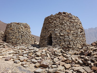
The area at the time was part of a long-distance trade economy, involving copper being transported from Oman to Mesopotamia. The settlement and necropolis of Bat are renowned for their Bronze Age funeral practices, with over 100 dry-stone beehive tombs. Associated sites nearby include the monumental tower of Al-Khutm and the group of beehive tombs of Qubur Juhhal at Al-Ayn.
Community Perspective: the chance of reaching these sites has improved over the years, also thanks to the directions provided in the reviews. The archeological site of Bat is fenced off so its contents stay mostly unreviewed (though Solivagant gained illegal entry), as is the case with the tower of Al Khutm.


Map of Bat, Al-Khutm and Al-Ayn
Community Reviews
Clyde

I visited this WHS in December 2020 after having visited Bahla Fort. Prior to visiting Oman I allowed quite a lot of time to prepare well how to access the different locations that make up this WHS. Maps.me is still the best option as there are still different locations erroneously marked with the same name on Google maps and road signs are non-existent (which I find quite strange as even the tentative sites I've visited were clearly marked).
The best time to visit is in the late afternoon but I would allow much more time to actually get to the first location and then to reach the next ones before it gets too dark. Keep in mind that the sites' magnificent mountain scenery in itself means that the sun will set behind the opposite mountains much earlier than the usual sunset time. Also, each location needs at best a short hike on loose rocks and desert terrain.
The first location I visited was Al Ayn (marked on Google maps as Al Ayn's Beehive Tombs) and chose the shorter Amlah-Wadi Al Ayn fully paved route off the highway 21 (just mind the few speed bumps which are nowhere as high as Mexico's topes but still Omani drivers tend to slow down to an almost dead stop upon approaching each one!). Just after passing by Amlah and Al Ayn, on your left hand side you'll be able to spot the long line of tombs on the nearest hill. I'd recommend parking near the small mosque on the right hand side of the road. From here you'll find a narrow trail which passes through a small patch of agricultural land and leads to a water-runoff crossing (from Jebel Shams) which seems like a river bed (I wouldn't visit just after spells of heavy rain!) and then shortly uphill to the tombs. The only sign you'll see is a brown sign mentioning that this is an archaeological site of the Sultanate of Oman but no mention of UNESCO. Jebel Misht soars behind the row of 21 tombs (19 still somewhat standing) of Al Ayn. I couldn't resist entering one of the larger tombs for a quick photo from inside (top right photo).
The eroded rock known as chert just beneath the tombs (top left photo) was used to construct these structures often called beehive tombs because of their appearance, which is similar to the traditional bee skeps of western Europe but also tower tombs due to the height of some of the tombs especially near Al Khutm. They are often situated in prominent locations such as the crest of a hill just like those in Al Ayn, and were clearly of importance within the society that created them and were built to impress, and certainly to endure the passage of time. They are dated from the 3rd and 4th millenium BC and each tomb was used over a period of many decades for the burial of dozens of individuals. That said, they might have had other purposes which are still being investigated by archaeologists or might remain unknown. Among the possible uses which have been suggested are: territorial markers (possibly also used as fixed points to calculate the movement of stars in relation the aflaj irrigation system), sites of pilgrimage and points of refuge for inhabitants of nearby settlements. Moreover, the principle of a circular structure with high, unscalable walls might have also inspired the nearby circular towers built in most of the forts around Nizwa.
After Al Ayn, we drove back towards Amlah and headed towards the paved road of Amlah-Ad Dreez in the direction of Ibri (with many speed bumps) to reach the remains of tombs, major towers and settlements of Bat after around 45 minutes. Only the last few metres are unpaved and very dusty but doable by non-4x4 vehicles. The first site, fenced all around, is one of a number of major towers within the site of Bat known as Qasr A'Rojoom, a niched structure constructed from monolithic blocks of stone and housing 13 small chambers and a well at the tower's centre. If for whatever reason you decide to use Google Maps, the location of this site is called City Pat Archaeological. Opposite this structure, you'll be able to spot the remains of several tombs beneath and on the slopes of the nearby hills. Even though the site is fenced off, it seemed as if the fences were there to prevent anyone from offroading without being aware that there is an archaeological site. Guided trips on 4x4 vehicles are possible too but might require booking well in advance. When I visited there were other locals visiting and on foot and it was easy to spot the narrow gaps which allow pedestrians to go through. I walked closer to the nearest hill with several tombs with varying levels of white limestone left on the tombs (bottom photos of two of the larger ones). I had to climb to the top of the hill to get a better look at the most complete tomb which is very similar to the one with the oryx embossed engravings in the Al Ain WHS of the United Arab Emirates.
After that, I drove further on towards the area marked as Bat Necropolis and Beehive Tombs on Google Maps where I could see more examples of these tombs. Here the site is completely fenced off except for a clear opening just behind the SAOC Primary Substation Antenna. I also looked out for a peculiar white limestone slab with an embossed engraving of a man and a woman which I had seen online from the City Pat Archaeological 2017 photos on Google Maps. This was either removed from the site as it was a mere modern engraving or else it was taken to a museum as it was nowhere to be found when I visited. Most probably the former is true as there is no mention of it on the UNESCO dossiers or anywhere else online. This would be plausible also in light of a similar experience I had at the tentative WHS of Salut which I'll mention in my separate review.
Unfortunately it quickly got dark by the time I spotted the offroad trail in the distance which leads to the higher lone tower tomb of Al Khutm (close to the date oasis and adjacent village of Al Wahrah) and so regretfully I had to head back to my car as I had no torch with me to find my way back. Even though information boards and possibly a visitor centre housing the remains still being excavated here will be surely added here in the not so distant future, with some prior preparation you'll still be able to appreciate these sites which I find possess OUV if only for the sheer amount of tombs and remains, the most iconic of which being those of Al Ayn. And for the time being, it's very likely that you'll have the place for yourself!
Els Slots

The Archaeological sites of Bat, Al-Khutm and Al-Ayn include a settlement and tombs in northern Oman, dating from the Bronze Age. This area was part of the Magan empire, which supplied raw materials such as copper to the Sumerians (in present-day Iraq). Although getting there has become easier over the years, it still is a nice off-the-beaten-track site seldom touched by non-WH travellers.
At 3 pm I hit the road from Nizwa, planning to be at Al-Ayn at the fabled ‘golden hour’ for good photos. I brought print-outs with me of the instructions given on this website to reach the locations of Bat and Al-Ayn. I skipped the even more obscure Al-Khutm in advance. Finding the excavations at Bat proved to be pretty straightforward. I used the approach via Ibri, where the biggest hurdle is avoiding the Pakistani/Bangladeshi men on bicycles riding against the traffic flow. Maps.me, which I used for navigating around Oman, knew a place called ‘Bat. Village. Oman’. This is the modern town, the archaeological site lies just one left turn away right before it.
I found the site strictly fenced off, there was no way to get closer to the round structures on the hills or the ruins by the road. Apparently, the site is still being excavated, and there seems to be no visitor policy. Earlier reviewers have reported getting behind the fences, but that seems not to be possible anymore. There is so little to see now that it was hardly worth it getting out of the car. On the right side of the road an intriguing, somewhat larger building is being restored: the square tower Qasr A'Rojoom (castle 1145 on the map in the UNESCO site documentation).
Getting to Bat had taken me more time than expected: I arrived at 5.15 pm. From here I had planned to continue directly to Al-Ayn, which lies 25km further along the same unpaved road. I tried it for one km but did not dare to go on: the ground was sandy and uneven. It would take me at least another hour to get to Al-Ayn, permitted that I would not get stuck. That way I would not be able to make it before sunset at 6.22 pm. So I saw no other option to turn back to the main road via Ibri, and try again for Al-Ayn tomorrow.
The next day, after first having visited the entertaining goat market in Nizwa, I was back on track at 9 a.m. Thanks to the very detailed and spot-on instructions by Brian Baum, I found the tombs at Al-Ayn easily this time (using the tarmac road exit from the Bahla-Ibri motorway). In true Omani fashion, there’s no sign, no information, and no one to bother you. There was a man working his field but he did not blink an eye while I was traipsing through the dry riverbeds and up to the hill.
The tombs consist of 'dry' stacked flat stones. There are still piles of the same material lying around it, so perhaps there used to be more. They are in such good condition that they appear to have been recently rebuilt. Each tomb has one small entrance. It’s a bit hard to look inside, but they seem to be empty.
Paul Duijzings
We visited both the sites at al ayn and bat and clearly the al ayn site is the most impressive in our view, because of the magnificent setting and accessability of the remains. At bat we were not able to access the area since it was all fenced off. Finding these archeological spots requires at least a gps next to a map, then one can find them with the help of some locals and a bit of luck....
Read more from Paul Duijzings here.
Brian Baum
Visiting World Heritage sites in Oman can be a frustrating proposition. The roads to the sites are usually not signposted and once you arrive there is little or no information to explain what you are seeing. Searching for these sites on the Internet is also very frustrating, with so much outdated or inaccurate information. I was at Al-Ayn at the end of January 2015, and fortunately I found it a very easy trip for anyone with their own transportation to make. As access to the site is completely unmarked, I took notes on what to look for on the way to and from the site. Hopefully you will find this helpful.
Heading on the motorway from Bahla towards Ibri take the exit marked "Amla / Wadi Al-Ain" which is approximately 40 km from the "Bahla" motorway exit. The motorway exit from Ibri is also marked "Amla / Wadi Al-Ain" and is approximately 53 km from the center of Ibri. To get to Al-Ayn from Ibri, follow the directions below from the petrol station.
From this stop sign at the exit, make a left and then a quick right just before the petrol station. You'll stay on this road for approximately the next 26 km (to follow these directions, you may wish to zero out your trip odometer at the stop sign). Look at the short dark brown hilltops off to your left after the first few kilometers and you'll see the some of numerous burial mounds that line the road on the way to Al-Ayn. At approximately 14 km you will see the first view of Jebel Misht just as you pass the gold domed mosque on your right. At approximately 24.5 km you will see several large blue directional signs as the main road turns to the left - continue on the main road (in the direction of Sint and Sant) - DO NOT follow the right arrow for Al-Ayn. As you round the bend (at 25 km) you will first see the mounds of Al-Ayn off on a low hill to the left. At 26 km you will see a mosque on your right. Pull into the driveway and then drive to the opposite side of the road to the stone covered parking strip directly across from the mosque. The car will now be pointed in the direction to take you back to the motorway.
Once parked, walk to the end of the sidewalk (towards the speed bump) and then down into the dry river bed. You will see an opening between two walls almost directly ahead of you. Continue into this entrance, following the path (staying to your right) until you come to a concrete water channel. Walk to the end of the first section of the channel and then turn left. That path will take you out to a second dry river bed (note the white metal gate to your left as you exit the path). The entrance to Al-Ayn is clearly seen at this point.
Back at the car, again reset your trip odometer. Retracing your drive back towards the motorway you will see more tombs in the hills on both sides of the road. At 13 km (at the last speed bump) the road splits off to the right for a shortcut back to the motorway to Ibri. Stay on the main road to head back to Bahla. The petrol station is at 26 km. To get back on the motorway to Bahla, turn right just past the petrol station. In about 1/2 km turn left to go under the motorway, turning left again and drive a short distance to get to the motorway entrance ramp.
Please note that Al-Ayn is really only accessible only to the surefooted. The site is built on very steep hills and the ground is covered entirely in loose rocks.
I visited Al-Ayn twice during my visit to Oman, once in the late morning and once in the late afternoon, about an hour before sunset. I highly recommend the beautiful golden light of the late afternoon. The site is magnificent and peaceful and you are not likely to share it with many other tourists. During my two visits I only saw two other persons there. There are no services of any kind at the site.
Frederik Dawson

“Beauty has an address” is the tourist promotion of Oman, but from my experience when I traveled in beautiful Oman, it was very hard to find address in this country even in GPS navigator or Google map especially in the case of the beautiful archaeological site of Al Ayn which at the end I had to use Google Earth and memorized all route details in order to reach the place.
On the expanding four lanes highway to Ibri from Bahla, there was a junction in the middle of desert that has a small petrol station, I turn right to the small paved road with no signpost next to that petrol station and continued on this way, passing many dry rivers and villages until I saw stunning view of Jebel Misht, one of the most impressive mountain in Oman. The surrounding Hajar Mountains were equally picturesque and interestingly show layer of rocks moved by seismic force that if in Europe or in China may already listed by some types of UNESCO program. When I reached the village of Al Ayn, again no sign at all I just presumed by myself, the area was lovely with green gardens with some palm groves, and I started to see the stunning view of a row of magnificent beehive tombs on the high hill behind the village together with unbelievable beautiful Jebel Misht as the background. Again I saw the beehive tombs but there was no way for car to reach the place or tourist information center, something that happened all the time in Oman. I found small unpaved road to someone house across the dry river, at first there should be a hiking route from that house to beehive tomb, but no! that house’s wall blocked all the possible pathway to reach tombs. So I decided to park the car on the dry riverbed and walked on such river until I found the small hiking route to reach the tombs. The size of the beehive tombs was my biggest surprise, these tombs were quite big and they were very well preserved, hard to believe its antiquity of 3000 B.C. I took a lot of photographs hoping to capture their beauty with Jebel Misht.
Sadly that there was no any information center to tell the outstanding value of this place, everything seem to be a mystery that why this necropolis be here in the very isolated area of Oman, I had a lot of questions for this site but at the end I really enjoyed Al Ayn, this world heritage site in my opinion, was the most exotic one in Oman and probably one of the most memorable site. I also recommended visiting this “Beauty has no address” in the late afternoon, as the sunset will make Jebel Misht and surroundings including beehive tombs at their best with beautiful and romantic red and pink tones but beware a lot of bugs and insects from the dry river bed.
John booth
It is essential to have your own transport to visit these sites. We drove from Al Ain (UAE) to Ibri and took the road viaAd Dariz to Bat where we found hilltops dotted with stone tombs. Some were restored, and within a wire fence we found the remains of the Al-Khutm tower.
From Bat we continued along a dusty but smooth road for about 25 kms until we reached a paved road which led to Al Ayn.These were quite spectacular, strung out in a long row along a ridge overlooking the wadi.
From Al Ayn we returned along the paved road which joined the main highway to Nizwa.
Jarek Pokrzywnicki

Site visited in December, 2010. Just arrived from Oman, seeing all their World Heritage Sites. It is not so bad with accessibility of Bat - there is a sealed road directly from Ibri via Ad Diriz. On a way from Ad Diriz there are already some marked excavations area (no named but at least there are plates). Just before entering Bat village you should turn left (road to Wadi Al Ayn). Bat archeological sites lies just 800 meters on the left. If you don't find it ask locals for UNESCO sites - the majority of them should know. Some structures extend also on the right side of the road. Total area is partly fenced, marked, graves or I should say structures are partly restored. One of those partly restored graves in Bat archeological site you can see on the photo.
For Al Ayn which is by far the most spectacular Unesco place in whole Oman, you can use the same road to Wadi Al Ayn - accessable but poor - but it is better to go Al Banah (watch for the signposts) and from there go to Al Ayn towards the road Ibri - Bahla. This road is now completely asphalted. If you enter Al Ayn just watch the hills - you cannot miss the graves.
anthony sun
This is a hard site to visit. First you need a guide because their are absolutely no signs to get you there. Next you need a 4 wheel drive as you are driving on dirt roads to get there.
The way there is to start at Nishwa and travel towards Al-Ayn. Half way you need to turn left into the dessert on a gravel road with no signs. The only landmarks are a small grocery store and a small mosque at the right side of the road at the junction. No other buildings around them. You pass through a small village and then the road takes you for 25Km into the dessert. There is no sign of civilization for the entire stretch except for electric lines on poles running on the right side of the road the entire way.
You know you have arrived when you see chain link fences on your left and right, some small white signs from the Oman Archeological Dept. and when the road dead ends in a power substation.
The chain link enclosure on the left are the remains of a circular palace. they do not allow close viewing and so you can only take photographs from a distance. he more interesting site is to the right. You need to back track till where the fence starts and enter from there. there are many mounds of rocks piled up where the beehive tombs were. Some have been partially reconstructed. The real interesting site requires driving the 4 wheel behind the hill to the right. Walking will take over an hour round trip. You come to another chain link fence enclosure where several bee hive tombs have been reconstructed. There is an opening in the fence where you can enter the enclosure. Great site for photographs.
Rob Wilson
I really loved Bat. It is incredibly remote, and isn't by any means a spectacular site, but there aren't too many places on Earth where you can walk around the remains on a 5000 year old settlement. It was also fabulous being the only visitors at the site.
Their are some tombs which are in excellent condition, and still resemble beehives, but like the other poster I ask any visitor to take the greatest care on this site. There is a real risk of damage due to theft and inconsiderate use of a 4wd. If you take a vehicle into the site, please stick to the well defined tracks.
Oh, and one big plus point is the entry fee - my favourite price.... free.
Solivagant

The brief desription on the UNESCO site was intriguing
“The protohistoric site of Bat lies near a palm grove in the interior of the Sultanate of Oman. Together with the neighbouring sites, it forms the most complete collection of settlements and necropolises from the 3rd millennium B.C. in the world”
Somewhere which is “world unique” should be worth seeking out! The Lonely Planet "Arab Gulf States" didn’t mention the place however. But it was there on the map which came with our rentacar and we did have a few spare hours after visiting Bahla and Jabreen forts before we had to be back in Nizwa. Unfortunately the route to it seemed to go round 3 quarters of a circle - there was a dirt road to avoid this but our rental agreement had been VERY specific that all insurance was void on dirt roads! When we reached the dirt road locals confirmed that it wasn’t good enough for a saloon. So on to Ibri which is on the main road from the UAR and the border oasis of Buraimi. From there we made our way north to Ad Dariz (turn off just before) and finally another 16kms to the village of Bat. If you try it you will need to keep asking at Ad Dariz as it is not well signed and locals do not seem be aware of what it is that tourists might be going to see. Just before Bat, where the metalled road ends, turn left - ie NOT into the village. After about 1 km you will come across a line of metal fencing on the left and a circular fenced enclosure on the right. This latter contains the structure shown in the picture on the UNESCO web site – the remains of a tower from around 2500BC.
You will need to go behind the fence to see the main area of beehive tombs. The fence is a farce since there is a rough road which just goes round the end of it. One must be concerned for the integrity of the site. Although Omani government notices warn that it is an archaeological site and that nothing must be damaged the whole area is open to plunder from locals wanting stones and from 4x4 enthusiasts driving everywhere.
The mention of a “Palm Grove” in the UNESCO description gives the wrong impression. This is desert country and the necropolis lies on dry ground over a large area with the remains of “beehive” tombs dotting both the valley and the tops of the surrounding hills. Unfortunately by now it was getting dark. Although I understand that there are at least 2 tombs in a reasonable state of completeness (ie looking like “beehives”!) we only had time to look at some which were in a poorer state of repair. The circular nature of the structure (see photo) was clearly visible however together with the skill involved in interlocking the stones to create the beehive dome. Some 4500 years ago a bronze age people had created a culture of some longevity and complexity of organisation and belief of which these stones were now the only record. The sun set deep red, the dust blew – and we had a 3 hour journey back to Nizwa . We may not have seen a magnificent ruin, well presented for tourists and beautifully restored but it had been a worthwhile excursion to experience these desert remains!
Community Rating
- : Juropa Fmaiolo@yahoo.com Laurine
- : Christoph Ivan Rucek Walter
- : Thomas van der Walt Hanming Wojciech Fedoruk George Evangelou Tarquinio_Superbo Martina Rúčková
- : Szucs Tamas Els Slots Vincent Cheung Bin Clyde Philipp Leu Philipp Peterer Randi Thomsen Csaba Nováczky SaoDies Frederik Dawson Jon Eshuijs Zach Jeanne OGrady
- : Roger Ourset Solivagant Svein Elias Mihai Dascalu Alexander Barabanov Mikko
- : Christravelblog Zoë Sheng Roman Raab
- : Harry Mitsidis Alexander Lehmann Tamara Ratz
Site Info
- Full Name
- Archaeological Sites of Bat, Al-Khutm and Al-Ayn
- Unesco ID
- 434
- Country
- Oman
- Inscribed
- 1988
- Type
- Cultural
- Criteria
-
3 4
- Categories
- Archaeological site - Prehistoric
- Link
- By ID
Site History
1988 Inscribed
1987 Deferred
Bat necropolis: Should include Al-Ain and better protection needed
Site Links
Unesco Website
Related
In the News
Connections
The site has 11 connections
Art and Architecture
Constructions
History
Science and Technology
Timeline
Visiting conditions
WHS Hotspots
Visitors
113 Community Members have visited.