Poverty Point
The Monumental Earthworks of Poverty Point comprise a pre-Columbian archeological landscape created by a population of hunter-fisher-gatherers.
The earthen mound complex consists of five mounds and six concentric earthen ridges. Set at a natural elevation, it was used for ceremonial and residential purposes by the vanished Poverty Point culture, which centered in the Lower Mississippi Valley between 3,700 and 3,100 BP. Mound A is the tallest of the constructions at 22m, and its size was only surpassed by the 2,000 years younger Cahokia Mounds.
Community Perspective: “extremely out of the way and not near anything”, you’ll find a small museum and a trail along the mounds. Visits generally take 2 hours, but if you aim to be there on an “archaeological day” you can have a try at Atlatl (spear-throwing) as well. The best way to appreciate the mounds is to look at an aerial view - either on the site's website or Google Maps.
Map of Poverty Point
Community Reviews
Jason Boulette
I'll admit, I recognize their historical importance, but I have a hard time truly appreciating the earthworks sites such as Poverty Point (I've visited two of the three in the United States, having also visited Cahokia Mounds but not yet visiting Hopewell). It's one thing to recognize on an intellectual level that these required tremendous planning and effort to build these structures, but on a visceral level, I hate to say it, but it feels like you're just looking at or climbing a small hill. I think my visit to Poverty Point was also marred by the fact that, as I perused the small visitor's center to try to understand the cultural significance of the site, the loudspeaker was blaring Vanessa Williams singing The Color of the Wind from Disney's Pocahontas movie.
Els Slots

On my recent trip to the eastern half of the USA, I visited all three ‘mounds’ or earthworks WHS: Cahokia, Hopewell and Poverty Point. During my preparations, I found the last one the most intriguing. And although it probably has the least remaining visible remains, after my visit I still think Poverty Point is the most interesting of the three sites.
The site isn’t visited that often as it lies in the middle of nowhere deep in Louisiana. I ‘did’ it as a day trip from Dallas by rental car – it’s 5 hours each way, which is long of course but it’s a straight shot east on cruise control and without much traffic. ‘Poverty Point World Heritage Site’ (this name is used on road signs to distinguish it from a nature park also called Poverty Point) lies just outside the cute towns of Delhi and Epps where everybody seems to live in a prefab house and have his or her own church.
Poverty Point is the oldest of the inscribed earthworks in the US. It was made by prehistoric hunter-gatherers who (at least seasonally) lived on the earthen ridges. In this lies the big distinction with the other two WHS that were merely ceremonial sites: because it was lived in, many artifacts have been left and rediscovered. The visitor center has display cases full of very sharp-looking spearheads, engraved objects, figurines that may have been fertility symbols and decorated clay objects. Some are so-called “Poverty Point Objects” – stones that were heated for use in cooking.
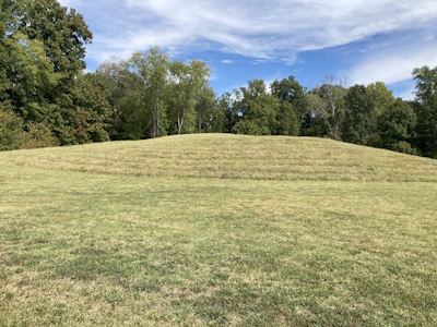
You can choose to visit the outdoor part of the site by car or on foot – for each, they give you a booklet with explanations of the waymarks. I chose the 4km long hike. Before you arrive at the visitor center you’ll notice what looks like farmland on both sides of the road – these are the main Earthworks! It took me strolling through the grass on the first part of the trail to understand that what I was walking on actually was ‘it’. This is the area where the concentric, C-shaped earthen ridges were made. Differential mowing of the grass makes them stand out more, and they are visible if you look hard. White markers indicate where traces of wooden post circles have been found. But this WHS truly is best seen from the sky: it wasn't until archeologist James Ford in the 1950s examined aerial photographs that he recognized the geometric design.
Similar to Cahokia, a fairly busy road cuts through the site (and the Earthworks). ICOMOS gave Poverty Point a Deferral advice (which was overturned at the WHC meeting) because it wanted to have the road diverted. I must say it did not bother me as much here as in Cahokia - at least they have a pedestrian crossing here. On the other side of the road from the visitor center, you can find the main mounds. These weren’t burial mounds and their use is unknown. A boardwalk will lead you up to the top of Mound A, with distant views of another earthwork, Lower Jackson Mound.
The trail then continues through a forest. The prehistoric people found berries here, there was water from a river and wildlife still uses it so it would have been good for hunting. It also has native pawpaw plants that carry edible fruits, which nowadays are used in fancy foods.
Overall it was a pleasant walk and I think the site management of Poverty Point has made the most out of the interpretation of this enigmatic site with its colossal earthworks. The site was only nominated under criterion iii, while Hopewell (with younger and smaller earthworks and oh, an active golf course instead of a road) this year also managed to get in under criterion i (a masterpiece of human creative genius) for the "enormous scale...and geometric precision" of its earthworks, which seems unfair to Poverty Point.
Read more from Els Slots here.
Blake
I went to poverty point in october of 2022, it is extremely out of the way and not near anything. I recommend it as a day trip if you go to new orleans. If you need gas or food the Farmer one stop right by it is something I recommend, it's not gourmet but it's a friendly little spot with a bit of everything. I spent about 4 hours on an archaeological day (highly recommend) there, about an hour and a half to hike the site, 30 minutes in the museum and the rest at the archaleogical day exhibits. Atlatl throwing was my favorite demonstration. I highly recommend the 15 minutes of film the museum offers before you do the hike, it was extremely informative. The Mound A is the highlight of the hike, pictures do not and as far as I'm concerned do not do it justice. It's something that you have to experience in person and it well surpassed my expectations I had for it. It has made me very excited to visit Cahokia soon.
Kyle Magnuson
California - United States of America - 08-Aug-21 -

A hunter-fisher-gatherer society of this size would have required a highly skilled group of people to sustain the community. During my visit, there was a Atlatl (spear-thrower) demonstration. After taking two throwing attempts myself, I could appreciate the skill needed to throw with accuracy. Located only 25 km from the Mississippi River, the people who lived here would have relied on extensive trade networks, as the "foreign" stone artifacts in the visitor center demonstrate.
The ICOMOS evaluation of Poverty Point ended with deferral, not because of lack of OUV, but because of Highway 577, which dissects the property and insufficient boundaries. ICOMOS wanted a buffer zone and preferred further research toward expanding the boundaries to include additional associated sites. Viewing the current National Park Service Map, the boundary of Poverty Point includes a Northern component that centers around Motley Mound, which is 2km North of the inscribed area. According to the Advisory Body Evaluation, this area was recommended for land acquisition. Perhaps there will be a minor boundary modification evaluated by ICOMOS in the near future. Regarding Highway 577, the road "visibility" is minor and the speed limit has been reduced. This is (in my view) an example where ICOMOS was probably too scrupulous in their evaluation, but ultimately I am pleased to learn the United States took steps to meet the recommendations after inscription.
The imagining of Poverty Point is perhaps more rewarding then simply standing in front of Mound A. When you see the satellite images, including Google Maps, the OUV of the site is easy to acknowledge. The artifacts in the visitor center help tell this story, but so much remains unknown. We left Vicksburg, Mississippi early in the morning to limit the effects of walking Poverty Point in the sweltering humidity of a Louisiana Summer. After two hours on-site, including a walk from Mound A to Mound B, we felt satisfied with our time learning more about this ancient culture.
Read more from Kyle Magnuson here.
Kelly Henry

Poverty Point was the largest earthworks structure in the Americas in the period between 1,700 - 1,000 BC. Built by Native Americans as a full-scale city, it is thought to be the center of trade for the Americas at the time and is sited just 25km from the Mississippi River. This site pairs well with the Cahokia Mounds site in Southern Illinois about 900km to the north - also near the Mississippi River.
While there isn't a lot to see today, you can get the idea of how the mounds created a giant "C" shape with easy river access that would facilitate trade. The remains of a dock are even still there. The small museum on site helps to better understand the site but the best way is to look at an aerial view - either on the site's website or Google Earth.
Logistics: I visited Poverty Point in September, 2014, just after it received World Heritage status. It was a 4.5 hour drive from my home in Dallas but Monroe, Louisiana is the nearest airport with decent air service. I agree that you'd need a car in order to visit this site. For US$4.00 you can have the run of the place - possibly even alone - as this site is VERY far off the tourist track. The site is managed by the Louisiana State Parks. Nearby you can find the American Civil War battlefield site of Vicksburg - just 50 minutes to the southeast and the San Antonio, Texas Missions World Heritage site is an easy 9 hours drive to the southwest. You'll need to go to either Vicksburg, MS or Monroe, LA to find the restaurants and hotels of any substance.
Jay T

The Monumental Earthworks at Poverty Point in northeastern Louisiana is the latest US World Heritage Site addition to recognize pre-Columbian cultures. The earthworks are the remnants of a culture that lived along the lower Mississippi River over 3000 years ago, and, although trees have grown and roads have been built, many of its mounds can still be appreciated in a walk around the site. I visited Poverty Point on a grey December day two years ago, and had the park almost to myself. After visiting the small museum, with its archaeological exhibits and overview movie, I started on the trail circumnavigating the site, aiming for the large, distinctive peak of Mound A, also known as the Bird Mound. From the top I could just barely make out the arcs of six concentric rings stretching out through the woods and fields, as well as smaller mounds on either side. The purpose of the mounds still confounds archaeologists, who postulate the area could have been anything from a settlement to a ceremonial site. The distinctive order to the mounds was hard to appreciate from the ground, so I highly recommend also looking at the site via Google Earth. I enjoyed my visit to Poverty Point, but I can understand the lack of architectural remains beyond the mounds will likely leave this site less popular to visitors than pre-Columbian sites in the west of the United States, such as Mesa Verde.
Logistics: The Monumental Earthworks at Poverty Point requires private transportation for access.
ted sojka
Poverty Point , LA
Circles
This city predates agriculture on the continent, and is located in Louisiana. The circular design is functional in many ways. There are six semi circular mounds that remain in concentric rings. The avenues that cut through the rings out of the city correspond to setting points of the sun on solstice days. Houses were constructed on the circular mounds in rows. No evidence of maize has ever been found on the site which covers hundreds of acres.
As many as ten thousand people may have gathered here during the Summers. The erosion has taken away some of the structure over thousands of years of flooding. They had clay, little stone, and very little wood to use in that area at the time of habitation.
The huge mound is seven stories high and is in the shape of a bird. There was little fire wood in the area, and clay briquets were heated in central fires and carried in clay pots to floor recesses in homes, and were used for cooking. Thousands of these decorated clay pieces, adorned with clan symbols are exhibited at the site in a museum on site. I saw dozens made in the shape of little owls. Red hot they would have held heat for a long time.
Ted Sojka
Art Educators of iowa
PS We arrived on a day when the temperature was near 95 degrees and the humidity somewhere between sweat and swimming. I crossed the six ridges of semi circular mounds and bounded up the almost seven story bird mound to take in as much as I could in one view. I had read about the site for years, and it was greater than I had imagined.
The museum was good but not many took the walking tour that day. The site is so large it was not even recognized as all one site until satellite imagery showed its real size.
Amy Martin
The oldest publicly-accessible evidence of ceremonial culture in North America -- and the largest earthwork in the world (I think) - and it's NOT a World Heritage Site? That simply does not make sense. Unlike most other earthwork sites, this one still sites in a landscape much like it did at it's peak, enabling visitors imaginations to form an idea of life for these moundbuilders. Not only is the main site still mostly intact, the outlying mounds are as well -- another rarity among earthworks. Group it with the even more ancient nearby Watson Brake, in university hands, and the mounds on the Frenchman's Bend Golf Course, and created is a prime example of the roots of humanity in North America.
Community Rating
- : Priyaranjan Mohapatra
- : Jeanne OGrady Mihai Dascalu Carl Le Boeuf
- : Tamara Ratz SHIHE HUANG
- : Bin Gary Arndt Kurt Lauer LuHa Kim, Soo-youn David Aaronson & Melanie Stowell Blake Svein Elias Els Slots
- : Randi Thomsen Hanming Xiquinho Silva Matthewsharris Cyberczar Kyle Magnuson Jay T Kelly Rogers Tommy W ZCTLife
- : Zoë Sheng Kelly Henry Michiel Dekker Alessandro Votta Dagmara Lichia Frederik Dawson Jason Boulette MichaelH Ralf Regele Mstrebl1990
- : Alexander Lehmann Bill Maurmann Little Lauren Travels
- : Thomas Kunz
- : Atila Ege
Site Info
- Full Name
- Monumental Earthworks of Poverty Point
- Unesco ID
- 1435
- Country
- United States of America
- Inscribed
- 2014
- Type
- Cultural
- Criteria
-
3
- Categories
- Archaeological site - Pre-Columbian
- Link
- By ID
Site History
2014 Advisory Body overruled
ICOMOS advised deferral, overturned by an amendment from Algeria for inscription
2014 Inscribed
Site Links
Unesco Website
Official Website
Related
In the News
Connections
The site has 12 connections
Art and Architecture
Geography
History
Human Activity
Individual People
Science and Technology
Timeline
Visiting conditions
World Heritage Process
Visitors
95 Community Members have visited.
The Plaque
 (photo by Els)