Atlantic Forest South-East
The Atlantic Forest South-East Reserves comprise 25 protected areas of rare remnants of Atlantic Forest.
The areas range from mountain summits to beaches and include marine and coastal ecosystems. Brazilian Atlantic Forest is the richest rainforest in terms of biodiversity. It has high endemism and a large number of tree species. Rare and threatened animals found here include primates such as the woolly spider monkey, southern muriqui, and four species of tamarin, while ocelot and jaguar occur as well.
Community Perspective: Jureia - Itatins Ecological Station seems to be the favourite location of our reviewers as it is within reach from Sao Paulo. Iain described some additional coastal locations, and João covered Intervales State Park.
Map of Atlantic Forest South-East
Community Reviews
João Aender

I visited another State Park that composes this WHS: Intervales. Atlantic Forest South-East is the only WHS in the State of São Paulo and some pristine areas of the State are within it. My favorites are Cardoso Island (a remote area where cars and new inhabitants are prohibited) and PETAR (full of caves, waterfalls and crystal-clear rivers). Intervales was a private area until 1995, when it became a State Park. The buildings formerly used for private purposes now belong to the State of São Paulo and are used as lodges. Interestingly, they are inside the park so that you can start your trekkings right after leaving front door. Intervales also has caves, waterfalls, cloud subtropical forest and rivers, none of those are as remarkable as the mentioned beforehand. But it is a delight for two or three days and I fully enjoyed being surrounded by nature for a long weekend.
Els Slots

I had already given up on seeing more of these Atlantic Forests than a couple of birds spotted on a short forest walk. But the owner of my pousada kept pushing his contacts for tours to materialize, despite (1) it being a week day while Peruibe & Guarau live on weekend trippers from the big cities, and (2) it had rained consistently all day and the outlook for the next day was only slightly better at ‘medium rain’. Finally, I was able to join a private jeep tour to Praia Caramboré and Barra do Una with a company called Bioventura.
The WHS location that I visited was the Jureia - Itatins Ecological Station, the same as covered by several other community members. Fortunately, it did not rain anymore when we left for the park at 7.30 am the next morning. As others have noted, the road conditions are terrible, and they are even worse after days of rain. But we had a trusty 4WD. The guide, Ed, told that he is participating in jaguar research in the area – but they hadn’t found one yet. Lots of pumas and ocelots though show up on the camera traps. We would see few birds and no mammals during our visit – the forest is too dense and the weather was too cold.
From the village of Guarau, we drove inland to the reserve; it does have a guarded entrance gate, but no fee or other administration is required to enter (more about what is in the core zone and what isn’t at the end of this review). We stopped a few times along the way: once to look at a waterfall with an interesting tree variety at its shore, including invasive species such as the Asian Breadfruit which is common here. The driver also found us some small, sweet bananas with seeds to eat from a wild plant at the roadside.
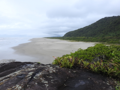
We parked at the entrance of a well-kept campsite (where we spotted a blood-red Brazilian tanager), and then walked downhill to Praia Caramboré. This is a sweeping beach of the typical Brazilian kind, Fernando de Noronha has many of them as well. Overhead we saw frigate birds fly, and on the beach we found a blue crab. At both ends of the beach, the mountains and rocks reach the sea. They are covered with plants such as bromeliads. What I liked best overall about this WHS visit were the parts like this where the forest and varied lower vegetation (often with flowers) contrast with the sand of the beaches.
Our next stop was Barra do Una. Here the Una River, with “water coloured like tea”, runs into the ocean. It’s a pretty place, with a dense forest and mountains in the background (see photo). It also has a density of mangroves. We met a local family which is the only one living in the Reserve on the ‘other’ side of the river. They had to drive with their ancient truck to the beach, get their boat to cross the river, walk for a bit and then meet up with a pre-arranged driver to bring them to the ‘city’ of Peruibe.
We finished the tour with a walk on Una Beach and a good fish lunch at a local restaurant, before driving all the way back on the bad road.
What is included in the core zone? Looking at the official map, it seems that the whole blackened area north of Iguape and towards Peruibe comprises the core zone of this location. Following that logic, the core zone of the WHS would be larger than the ecological reserve. It would include the town of Guarau for example, and the winding road between Peruibe and Guarau. However, Jureia - Itatins Ecological Station is an IUCN category I protected area; this means for example that “Human visitation is limited to a minimum”. That does not correspond with the number of guesthouses and campings present, especially in the beach areas.
To make things more complex, in 2006 the Jureia - Itatins Ecological Station changed its boundaries and was transformed into the Jureia-Itatins Mosaic, covering also Barra do Una Sustainable Reserve and Intingucu State Park for example (category IV protected areas). These combined cover much more hectares than the original nomination. These changes in management structure are not reflected in any way in the official WH data, there also has been no SOC at all since the inscription in 1999. In my opinion, it is likely that the core zone only covers the strictly protected Jureia - Itatins Ecological Station; the one entered at the gate and also where the Paradise Waterfall is.
Read more from Els Slots here.
Philipp Peterer

Like Jarek, I chose Peruíbe for my visit. It is probably the most convenient location to visit and took around 3 hours by rental car from Guarulhos airport. If you arrive at Congonhas it’s even closer, as you don’t have to pass through the center of São Paulo.
I spent the night in Guaraú, a village close to Peruíbe within the core zone. Guaraú beach is nice with some beautiful views over the park. I saw a lot of different birds early at the beach and only around 3 other people. As it’s not a overdeveloped touristy beach, it is still very much enjoyable. The nearby island also seems very nice from the pictures I saw, but with my limited research I didn’t find a way to get there. Instead I drove to the Paradise Waterfall.
The drive to the waterfall took 50 minutes, even though it’s only 12km. You can guess the road conditions when reading these numbers. Unsurprisingly the waterfall was not worth the effort to drive there and back. The low water level added to its unspectacular height and the cloudy weather gave it the rest. However, I’d still recommend doing, as the beach alone is not representative enough for this WHS and I only got the real “core zone feeling” when driving through the jungle on this muddy, rocky, bumpy, so called road. You can spend a month there, exploring this huge area, but a full day covers it pretty much.
Jarek Pokrzywnicki

Just visited a part of rainforest (March 2013). As the site consist of several reserves, National Parks or ecological stations and mostly due to bad weather I decided to stick to one location to have an overall view of the area.
Because of communication issues I go to Peruibe (4 hours by bus from Sao Paulo - Terminal Rodoviário de Jabaquara, there are several buses daily) as the starting place for Jureia-Itatins Ecological Station, in fact a huge reserve, located just close to Peruibe town. If you cross the river you are already in the Jureia Park. The most beautiful place and highly recommended is called Cachoeira do Paraíso and is located some 25 km from Peruibe (there are some buses daily to get there at least in theory, because due to weather conditions the bus may occasionally not operate - it is better to check on Peruibe bus station a day before) or you can walk - on the asphalt road it is possible to hitch-hike.
It is written everywhere that there are only certain amount of people entitled to go to Cachoeira do Paraíso (small lake and waterfall, photo) but I did not encounter any troubles to go there - it is also not necessary to have licensed guide to go there as the path is well marked.
Some practicalities: I stayed overnight in Peruibe. There are a lot of accommodation places as this is huge touristic resort (Atlantic Ocean). Bus terminal (Terminal Rodoviário de Peruíbe) is located in the southern part of the town. From bus station there are occasional local buses to Jureia-Itatins Ecological Station (Nucleo Itungucu or Barra do Una). Good asphalt road is from Peruibe to Guarau hamlet, afterwards there are only unpaved local roads.
Iain Jackson
This is one of the largest, and most fragmented WHS I have ever visited. It consists of about 25 protected areas, National Parks, State Parks, Ecological Stations, wildlife Zones etc.
Some do not allow casual public access while others see large numbers of visitors, mostly, unsurprisingly, Brazilians.
In January 2009 I came off an overnight flight from London at Sao Paulo, took the city bus to Barra Funda bus station and from there a coach to Cananeia.
The site comprises of the Serra do Mar coastal mountain chain (with a maximum height of about 1400m), the coastal plain, the coastline itself and a number of offshore islands.
I had about 4 days in which to explore this huge and diverse area. I could find no way, using public transport, that would allow me to see both the karstic uplands and the coast so I decided to limit myself to just the coastal areas.
Cananeia is a small, characterful sea side town from where I made the brief ferry crossing to Ilha Comprida. My exploration of this large island were severely limited by the lack of public transport.
Throughout the 4 days the weather was never good, with a lot of heavy rain and low cloud so that next day a planned trip to Ilha do Cardoso had to be aborted.
I retreated to Curitiba, looking, unsuccessfully, for drier weather inland and the following day took "the best train ride in Brazil" to Morettes. It may well be but I'm afraid that once again bad weather made it impossible to tell.
From Paranagua, an attractively decaying port in the rain, I took the ferry down the mighty river estuary to Ilha do Mel.
This was a pleasantly relaxed place with gentle waves lapping almost on the steps of the Youth Hostel on the western side of the island while only a few hundred metres walk across the isthmus which joins the two parts of the island mighty Atlantic breakers were crashing onto the shore.
In the whole of the area that I saw, where man has not cut down the trees, vast dark green wet forests stretch over the hills into the distance.
I would welcome the chance to go back to this area in better weather and explore some more, particularly in the limestone hills and caverns inland.
"
Community Rating
Site Info
Site History
1999 Referred
As "Lagoon complex of Iguape" and "Paranapiacaba - Upper Ribeira": Bureau - Brazil tried to convert 3 sites into 2 part way through the process
1999 Revision
Includes former TWHS Estuarine Lagoon complex of Iguape-Cananéia-Paranaguá (Lagamar Complex) (1999) and "Paranapiacaba - Upper Ribeira"
1999 Inscribed
Site Links
Locations
The site has 25 locations
Connections
The site has 28 connections
Art and Architecture
Ecology
Geography
History
Human Activity
Timeline
Trivia
WHS on Other Lists
World Heritage Process
Visitors
66 Community Members have visited.
The Plaque
No plaque has been identified yet for this site.