Yakushima
Yakushima contains the remains of a warm-temperate ancient rainforest and it is the last ecosystem dominated by the Japanese cedar.
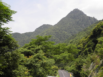
This small and very wet island has high peaks up to 2,000m, all covered in dense forest. It includes a primeval forest of the Japanese cedar or Yakusugi, an evergreen tree that can grow very large in height and diameter. Some of the trees are over 1,000 years old.
Community Perspective: this lovely island can be reached by ferry from Kagoshima, but be aware that the core zone only covers the higher altitude central part, with arms stretching south, east and west to the coast. The hardcore option is to do the hike to Jomon Sugi (8-10hrs; Aovana, Randi & Svein and Zoë did so); an alternative, easier way is to take the Seibu Rindon Forest Path near the coast.


Map of Yakushima
Community Reviews
Randi Thomsen

Having spent the last three weeks travelling “mainland Japan” we arrived Yakushima mid July 2023. The same means of transport (ferry) as everybody else took us from Kagoshima to Miyanoura Port and we started the visit by renting a small car at the harbour.
We drove immediately towards the Yakasugi Museum close to Anbo harbour. We had already decided that we wanted to do the long hike to Jomon Sugi the next day. At the bus stop close by there was a small kiosk that sold tickets for the hike.
We stayed the night in a guesthouse in Anbo called La Isla Tasse, very convenient for the hike. The next morning we left at 4:15, with packed breakfast and lunch. At the bus stop we had some trouble understanding the Japanese queuing system, but we finally found our place. At 5 we were on the bus leaving for the trail base. It started raining during the 40 minutes bus ride, so we prepared by pulling out our raincoats. Starting the hike with several others from our bus we were surprised by the Japanese culture of always using umbrellas, but only 5 minutes into the hike we understood! In this humidity a raincoat makes you more wet on the inside than on the outside, thus umbrellas for everybody – even on a long forest hike. Luckily the rain stopped after a short while.
The trail is on a narrow-gauge railway track which is not steep at all even though the area around is steep. The hike is between the hills and goes through tunnels and crosses the river several times. It is a 9 km hike on this railway track, and it took us about 2 1/2 hours. Then the more challenging part, the 2.8 km forest hike. It’s mostly upwards – but some downwards as well - on ladder-like stairs, rocks, roots, and the uneven forest floor. There were posters with “proceed with caution” and “please watch your step”, but it’s really no problem. The problem is the moist and the heat. Drinking water is essential. There are several places to fill up your bottle btw. About 3 1/2 hours into the trip, we reached our first goal – the sign telling us we were entering the Yakushima World Natural Heritage Property. Wonderful! Another 30 minutes later we reached our second goal, the ancient Jomon Sugi Cedar tree! A series of wooden platforms made us able to study the huge old tree (and all other trees surrounding it) without trespassing the “intimate zone” of the tree. Very nicely done! And the tree is majestic!
We were about to have our lunch break immediately when we discovered the sign saying “no food on the platform” – so we had to move our lunch somewhere else.
The vegetation is primeval in every sense. The living trees, the fallen ones – all covered in green moist moss, all the shapes all around – makes it a jungle although different from the one at the coastline. It was kind of disappointing there were no animals to see, only birds here and there.
The return trip was easier, but it starts tiring your muscles and body. We used about 8 hours in total – and we didn’t rush. Then we had to wait for an hour for the first returning bus.
For the next two nights we stayed at a simpler, but nice guesthouse close to the Miyanoura Port called Minnsyuku Yakushimaya, with traditional Japanese rooms.
The second full day we used the car to see the island and the “other side” of the core zone. No hikes today, the legs needed a rest. Els has explained this in detail, but it helps to get there with a rental car. There are some nice, deserted beaches on the way. It seems like the Japanese are more into onsen than beaches. We enjoyed a beach and a swim and had a wonderful lunch with a view at a little café called Sea & Sun.
The following morning, we had an early ferry back to the Kagoshima, but we were fooled. The 7 o’clock ferry was not departing from the Miyanoura Port, but from Anbo Port. A minor mistake as we got new tickets for the 10:20 ferry. We got a delay but nothing serious.
We had a wonder couple of days on the (kind of remote) sub-tropic Japanese island, a highlight on our Japan trip!
### Randi & Svein Elias
Zoë Sheng
Chinese-Canadian - 10-Oct-18 -

Yakushima is one of those places that just wows you as you even get close to it. It's so amazingly green for one, and the mountains seem to stretch forever even though the island is quite small. Most visitors seem to do a 2 day trip, with the first day of arrival making a visit to Shitatani Unsuikyo (ravine) which inspired the movie Princess Mononoke. This part is great and a 3h hike through mostly roots, rocks, rivers and steps prepares you well for the rest of the hikes on the island. The ravine is NOT inside the UNESCO protected area but I do recommend it for a half-day trip after landing on the island assuming the water levels are low as the river crossings aren't easy.
Yakushima was inscribed for 2 reasons. The "natural beauty" is a little odd-ball because those opinion-related inscriptions are all in the eye of the beholder. The second one is for the vertical distribution that changes with altitude and can be easily observed inside the protected area. There is a great illustration of this inside the World Heritage Center up at the Yakusugi Land museum (free entrance for the center and lots of info on world heritage, Ramsa and other stuff around the island). Basically they make an example that the height of the island has similar climate as up north in Hokkaido but the island is located very south, and the vegetation has EVERYTHING of Japan in one tiny spot, i.e. from subtropical to cool.
Day 2 is that grueling ~10 hour hike to Jomon, the oldest tree on the island, or in Japan? It is the oldest cedar tree in the world apparently. The reason the cedar trees grow older than the usual 1,000 year life span is that the soil is not very rich and they need to grow thicker rings to survive, thus these tough buggers outlive us all. This all-day hike starts with a bus to the museum early morning before sunrise and even in October, Japan's Sports Day of all days, there were many people in line for the shuttle bus to the trailhead. Speaking of the national holiday, I was expecting a lot of people with families but in fact the school kids only arrived in large groups the day I was leaving and only 4 kids did the long hike. The hike only takes you into the world heritage area for the last 30 minutes or so. The Jomon tree is naturally inside this area. There are many hikes that go across the mountains that are less popular and one has to arrange staying in the huts on the mountains. One could, for example, hike from Shitatani Unsuikyo towards Jomon and even continue further west through the world heritage area. Was the hike worth it? Probably yes, but I found the 2.5h trek along the train lines merely interesting for one way and the return was a little pain in the butt even if you get lucky to see deer, yakushimazaru, weasel, (poisonous) snakes, mushrooms. Birds were kind of scarce although you can hear the chirp far up in the trees I didn't see a single one. The tough sections for the last 2h has amazing forestry and several stops on the way. Many Japanese hikers went in groups and the tour guide stopped a lot of times to point out growth behavior, flora and fauna, photo shoots at the big trees, the rest I couldn't guess. There is ample supply of fresh water flowing down the mountain to never worry about carrying too little and the fresh crisp mountain water will boost your energy. In fact since the hike is always in the shade I broke very little sweat. The next morning the legs were rubber though.
If you don't do the hike, the world heritage site stretches all the way to the west coast where buses aren't allowed to go through. Some people in the tourist information center inquired about what to do and they were suggested to seek out a waterfall. I don't find that worthy of coming all the way to Yakushima but so be it. If it is possible to see the vertical distribution of the vegetation there I am not sure. The bus system is a little slow around the island and it might be worth having an IDP to drive either a scooter or car. The "Kei" electric cars are very popular.
If you come in summer you can also observe the loggerhead turtles.
One of my favorite WHS and it happened to be my 500th so I'm very proud of this achievement.
Gary Arndt

I visited Yakushima in 2007.
Yakushima is my favorite world heritage site in Japan, hands down.
When I visited, I was the only non-Japanese person I saw on the island. Being located south of Kagoshima, the southernmost city on Japan's four main islands, it isn't on the radar for most tourists visiting Japan.
Yakushima was the inspiration for the animated film Princess Mononoke.
A cedar forest located in the clouds on top of the island, the mood can be very eerie and surreal.
Read more about Yakushima on my website.
Els Slots

I arrived at Yakushima’s Miyanoura Port from Kagoshima by jetfoil. There are several boats a day by various companies, which is indicative of the popularity this island has among Japanese holidaymakers. People do come here mostly for hiking, and in the main street of Miyanoura well-outfitted Japanese hikers is a common sight. The town itself has a few thousand inhabitants, several good restaurants, a large supermarket and places to stay. And plenty of souvenir shops, of course, selling mostly wooden items.
Hiking is what I did on my first full day too. I went to Shiratani, located a mere half hour uphill by bus. This is the starting point for several short and longer walks. The drive up there already was enough to win me over for this island. The scenery really is spectacular – trees, trees and more trees, in every shade of green that exists. I was on a “normal” local bus, but the bus driver halted at a viewpoint anyway to let me and 6 fellow passengers take photos of the landscape. And he did so too when we encountered a group of Japanese macaques by the side of the road. Many “oohs” and “aahs” were uttered at the sight of these monkeys just next to our bus. It even got better when they were joined by a Sika deer. So we had seen the two most prominent mammal species of the island before even getting into the national park.
At Shiratani, I opted to hike the full loop (about 3 hours long). The trail is well-marked by fluorescent pink ribbons that are tied to trees. I guess someone walks out there every morning to tie new ones. The first half of the walk leads up to Shiratani Hut and is quite easy. At least I thought so until I had to cross a stream marked on the map with “watch out for high water”. Japanese are no wimps, and hikers of all ages managed to cross the stream by stepping/jumping from stone to stone. Maybe it helps when you’re covered in expensive gear. While I was watching them and trying to find some courage in myself, I saw a troop of monkeys appear. They crossed the stream also, not disturbed at all by the presence of humans. And they also had a little Sika deer in tow. A very fun thing to watch. It gave me enough of a boost to cross this and many of the other streams that were to follow. Of course, I passed several of the old Sugi-trees too, some of which have split at the bottom so you can walk through them.
The second part of the hike became more of a run, as the rain started to pour down. I saw no more animals, and I found the forest even more dense and gloomy on this side of the route.
So in one day, I had seen it all, the island's most remarkable flora and fauna. But I did not enter the core zone of the WHS! Although almost the whole island is covered by ancient forests, the designated part is a smaller area that includes the highest mountains and the untouched forests. It is also smaller than the national park, leaving the Advisory Body to suggest an extension could be useful (“Some prime areas of old-growth forest and some scenic features and waterfalls fall outside but adjacent to the nominated area”).
Therefore the goal for my second day in Yakushima was to set foot into the core zone. It is also the least accessible zone of course. But I found out that the WHS extends to the coastline in the western part of the island. It also includes a scenic road: the Seibu Rindon Forest Path. It is too narrow for buses, but I could get to the Ohko-no-taki waterfall and walk from there. It looked like a 3 to 4-km hike on the map, and in reality, it surely wasn’t more. Fortunately, it was a very sunny day. After about 40 minutes I encountered a signboard “Welcome to the Natural World Heritage Area”, with a map clearly showing “You are here” – just at the border of the core zone! I strolled around for a bit, enjoying the fine views of the forested mountains, and encountering even more macaques and deer. I heard and saw many more birds here than at Shiratani, probably a sign that it is quieter on this side of the island.
The conclusion of this review may be clear already: Yakushima is a lovely getaway island.
Read more from Els Slots here.
Aovana Timmerman
I travelled to Yakushima this year in April. The purpose was to see this 7000 yr old cedar tree called Jomon Sugi by the locals. To get to yakushima, we caught the rocket ferry (fast ferry) from Kagoshima.We stayed at the Youth Hostel there and it was clean comfortable accomodation with english speaking host. We were given very clear directions and maps on how to climb to Jomon Sugi. The next morning, we set off around 430am very early to catch a bus to the starting point of the walk. By the time the bus got there , it was alredy 6am. It took us 5 hours to get to Jomon Sugi and another 5 hrs to get back to the starting point .. we saw monkeys, birds,snakes, lots of unusual mountain plants, streams, rivers.. it was just all very well preserved. The walk is very well maintained..and most of the time, you walked on the old railway.. or on wooden steps. sometimes, you will have only dirt tracks and tree roots and rocks to walk on. By the end of the whole walk, I think we were all ready to catch the bus and get back for a shower at the hostel. Good things too about Yakushima is the seafood there, the wagyu beef there. The Japanese people there are so friendly.. and we met one that spends a whole week trekking around Yakushima. Its an amazing island to go to.
Site Info
Site History
1993 Inscribed
Site Links
Unesco Website
Official Website
Related
In the News
Connections
The site has 20 connections
Ecology
Geography
Religion and Belief
Trivia
Visiting conditions
WHS Hotspots
WHS Names
WHS on Other Lists
World Heritage Process
Visitors
45 Community Members have visited.
The Plaque