Pitons of Reunion
The 'Pitons, cirques and remparts' of Reunion Island are renowned for their visually striking landscape and remaining high numbers of endemic plant species.
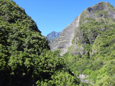
The site consists of two adjoining volcanic massifs, with remparts (steep rock walls) and the three cirques (imposing natural amphitheaters) of Salazie, Mafate et Cilaos that evolved due to erosion and volcanism. The Pitons are covered with subtropical rainforests and cloud forests.
Community Perspective: Kbecq has described the four tough hikes he did here on volcanic terrain, while Els hiked into the Cirque de Mafate.
Map of Pitons of Reunion
Community Reviews
Els Slots

‘Completing’ France is a tough act, as its WHS include sites in four overseas territories scattered across the globe. The French Austral Lands are the hardest (9,000 EUR/28 days if you’re lucky to get a spot). Somewhat near in the Indian Ocean but much more accessible is Réunion, served by daily direct flights from Paris. This island is governed as an overseas department and its culture is very, very French. Réunion is blessed with its own WHS, the Pitons, Cirques and Remparts.
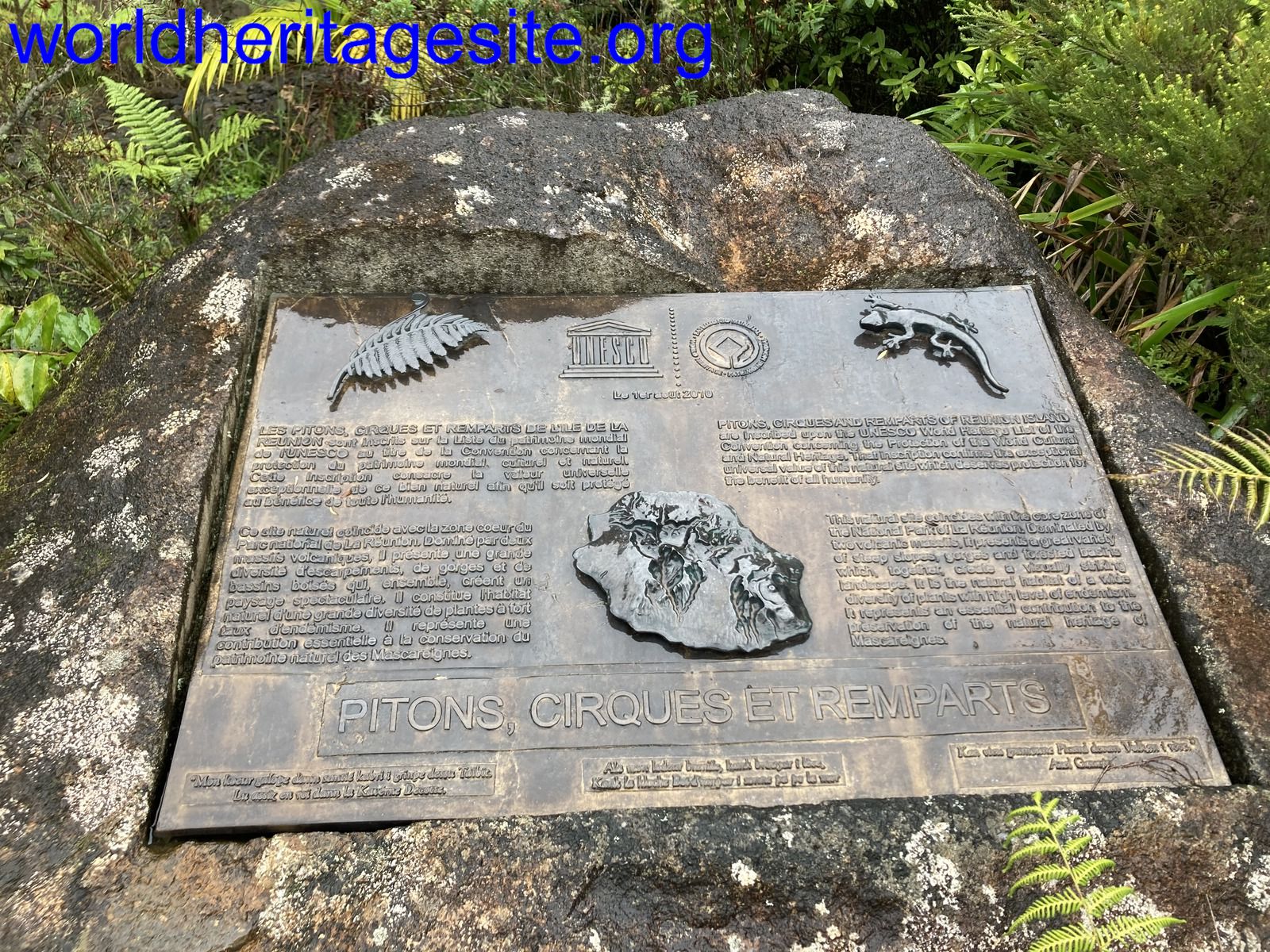
The WHS area geographically is a bit complicated, although it would be hard to never set foot in the core zone while spending a few days on the island. Generally, it covers the whole interior, but, it’s a WHS with an enclave, three enclaves even: they are the villages inside the cirques. And, the WHS is slightly larger than the national park. La Maison du Parc in La Plain des Palmistes, which acts as the park’s visitor center, has a very clear scale model of the island depicting the park’s borders and the WHS extras. I discovered the WHS plaque there as well: it is situated in a flowerbed to the right, about 10m before you enter the building. This WHS overall scores very well on the scale of the WHS commandments, with the wonderful bespoke plaque, the scale model showing core and buffer zones, and the park also being free to enter.
For my deep dive into the park, I choose the Cirque de Mafate. Measuring 14x9 km, it is shaped like a massive natural amphitheater, surrounded by steep ramparts: the result of a collapsed volcano. Due to its inaccessibility, it served as a natural shelter for runaway slaves from Madagascar, who arrived in the 18th and 19th centuries. Even nowadays some 700 people live inside the cirque, though there still is no road access and provisions have to be delivered by helicopter.
I went there on a guided day hike organized by BMR. It departed from the 4×4 car park on the Rivière des Galets in La Possession in the north of the island. This proved to be a popular starting point, and locals run a blossoming 4x4 business from here. The parking is the last place you can reach on your own (I got there by bus from St. Denis to Sacré Coeur + a 20-minute walk). Then you get into one of the 4wd trucks that will take you half an hour to the starting point of the trails. They drive on a rough unpaved track, which includes several river crossings. There and also later on during the hike we met lots of trail runners, a popular pastime here which culminates in the yearly Diagonale des Fous which fully crosses the rugged backbone of Reunion.
We were probably the guide’s tour group from hell: a Bulgarian guy who couldn’t speak French, a French woman who faired well until she started feeling lightheaded and had to lay down so we eventually had to abort the hike 30 minutes from the final viewpoint, and me – a slow climber, bad at descends too and taking even more time along the way to take pictures of birds. Honestly, I would have been just as happy if they had left me somewhere halfway, so I would have had more time to take in the scenery and take better photos of the plants and animals. The most notable sightings in the latter category were those of two tenrecs, a species that has spread to here from Madagascar and looks a bit like a mix of a hedgehog and a rat.
Hiking in Mafate is strenuous because of the technicality of the terrain, and having hiking poles really is a must (I had arranged some via the guide beforehand). At the start of the hike, you have to complete four river crossings, which can be done via stepping stones. I already failed at the first one and waded through the others as well. The water came to my knees, but the river flow wasn’t too strong. In every family/group I noticed at least one person struggling to make the crossings. Along the trail, three footbridges have been added to cross more dangerous ravines. Climbing is mostly done via stairs, which says enough about the steepness of the area. There are no easy hikes in Mafate, and the opportunities at the other two cirques are only slightly better.
Read more from Els Slots here.
Kbecq

Contrary to its neighbour Mauritius, Réunion island does not have a lot of beaches so most people (including ourselves) come for hiking.
Over the course of four days we did four hikes: (i) Trou de Fer, (ii) Col du Taïbit/Marla, (iii) Piton des Neiges, and (iv) Piton de la Fournaise. These and more hikes can be found on the website https://en.reunion.fr/organize/hiking-trails where also GPX tracks can be downloaded and practical information is provided (where to park, distances, …). However, we didn’t need GPX tracks since all hikes are well marked.
Whatever hike you do, it is recommended to do it before noon since later in the day the clouds come in limiting visibility and consequently blocking the nice view you hoped to have after climbing for a couple of hours.
Below some comments per hike we did (end of September):
Trou de Fer: large car park at the Gîte de Bélouve / start of the hike. In principle, this is a easy walk but the day(s) before we arrived it rained and during our walk it started raining again making the trail very very (ankle deep) muddy. We even considered turning back but in the end made it to the viewpoint which was worth the hassle.
Col du Taïbit: only a couple of parking spaces at the start of the route so start early (but alternatively there is a bus stop). The route goes up to the Col du Taïbit and back down to the village of Marla in the cirque (caldera) de Mafate which can only be reached by foot. The hike is classified as hard but we only went up to the Col du Taïbit where you have a nice view over the cirque and Marla.
Piton des Neiges: this hike is also classified as hard and we can confirm that it is! Most people do this walk in two days, spending a night in the Dufour Cave refuge but we decided to do it in one day. This meant starting at 2AM and about 6 hours (and 1.700 meters difference in altitude) later we arrived at the top where you have magnificent views over the cirque de Cilaos. Getting back down took us 5 hours.
It’s not a technical climb but hours and hours of large steps, small boulders as from the refuge and sand/gravel/scree at the end. Without question the hardest hike of the four.
Piton de la Fournaise: large car park which is necessary because this is probably the walk that attracts most people. The last couple of kilometers of road to the parking are in bad shape (full of potholes), but nothing a standard car can’t handle.
Although this hike is also classified as hard, it’s much easier than the Piton des Neiges. There are some steeper sections but it’s perfectly doable for a normal physically fit person. The hardest section is actually at the very end when returning to the car park where you have to go up again.
In terms of variety this is probably the nicest walk of the four (lava fields, view of the crater, …).
This selection of hikes and driving around the island gave us a good impression of the 'pitons, cirques and remparts' of Réunion and its beautiful landscape!
Jarek Pokrzywnicki

Non argueably one of world's wonders. Tropical forests, cirques, volcano, steep mountains, canyoons, watarfalls, everything can be found there.
Reunion National Park covers relatively big area almost entire interior (except those around villages), easy accesible by foot (marked trails) or bus. For those with limited time the best starting point to see the cirques is either Cilaos or Salazie (both accessible by bus).
For visiting the volcano (Piton de la Fournaise) it is better to have your own / rent car good road from Bourg-Murat up to Pas de Bellecombe (free parking). Otherwise it is a half day walk up to Gite de volcano. Piton de la Fournaise resembles Teide of Tenerife but at least the crater area is much, much bigger.
Community Rating
Site Info
Site History
2010 Inscribed
2009 Postponed
"This decision was required due to the fact that three nominations from France were proposed for consideration by the 33rd Session of the World Heritage Committee. The State Party of France had been requested by the UNESCO World Heritage Centre to identify two nominations in line with the limits on annual numbers of nominations set in the Operational Guidelines." (AB ev)
Site Links
Unesco Website
Official Website
In the News
Connections
The site has 20 connections
Ecology
Geography
Human Activity
Timeline
WHS on Other Lists
World Heritage Process
Visitors
75 Community Members have visited.
The Plaque
 (photo by Els)