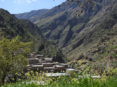
Hawraman/Uramanat

The Cultural Landscape of Hawraman/Uramanat bears testimony to the traditional semi-nomadic agropastoral way of life of the Hawrami people.
The landscape comprises agricultural villages and their lands in two valleys in the Zagros mountains. The semi-nomadic inhabitants perform steep-slope agriculture using traditional dry-stone terracing and water management practices.
Community Perspective: Zoë mostly enjoyed the journey through the valleys.

Map of Hawraman/Uramanat
Community Reviews
Zoë Sheng
Chinese-Canadian - 08-Oct-24 -
I was driving here in the off-season which isn't a good idea in general. This is off a small road leading from Kermanshah to Sanandaj and there wouldn't really be any reason to go here but for the world heritage site. It doesn't usually drop below zero Celsius much here and you shouldn't expect snow but it's still quite chilly. You can see the valleys from this road. The actual spot to visit is called Palangan Tourist Village just aside this road. It is made very touristy on purpose although the Kurdistan formalities don't mean it's tacky or selling out. Because I came in the off-season nobody was really here or expecting tourists. The main point of interest will be viewing the valley plus the houses that rise up the mountain. I've seen similar in Saudi Arabia just definitely not with the Kurdistan ethnicity. Normally there are sellers with shoes, cloths and other baskets, snacks among the collected food, but everyone was staying home during my visit.
Palangan Rural Museum was open and it shows off some tools as well as medical plants found nearby. It helps to understand people do around here a bit better but not really worth the trip. The journey through the valleys, as treacherous as the roads are, was definitely better.
Community Rating
Site Info
- Full Name
- Cultural Landscape of Hawraman/Uramanat
- Unesco ID
- 1647
- Country
- Iran
- Inscribed
- 2021
- Type
- Cultural
- Criteria
-
3 5
- Categories
- Cultural Landscape - Continuing
- Link
- By ID
Site History
2021 Inscribed
Site Links
Unesco Website
Connections
The site has 34 connections
Art and Architecture
Constructions
Ecology
Geography
History
Human Activity
Religion and Belief
Timeline
Trivia
Visiting conditions
World Heritage Process
Visitors
9 Community Members have visited.
The Plaque
No plaque has been identified yet for this site.