Colchic Rainforests and Wetlands
The Colchic Wetlands and Forests comprise two warm-temperate humid ecosystems: ancient Colchic rainforests and wetlands with bogs and mire.
The seven parks consist of low-altitude wetlands, close to the Black Sea on one side, and higher-altitude ancient deciduous rainforests enclosed by mountain ranges on the other side. Their very wet conditions have led to high levels of endemism and intra-species diversity. The ancient forests are among the most important survivors of the glacial cycles of the Tertiary.
Community Perspective: not all components can be (easily) visited. Mahuhe describes a trip to Mtirala National Park from Batumi, while Stanislaw covered Kintrishi-Mtirala and Pitshora and gave some hints about the illegal entry of two others. Nan added more practical information.
Map of Colchic Rainforests and Wetlands
Community Reviews
Els Slots

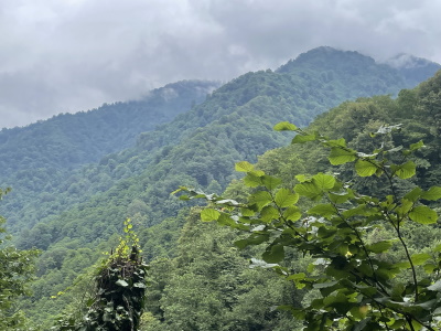
The Colchic Rainforests and Wetlands, being a distinct Floral WHS, never appealed to me much. Still, it was a shoo-in in 2021 as IUCN easily confirmed its global significance (“one of the two most important refuge areas of Arcto-Tertiary geoflora in western Eurasia”; the Hyrcanian Forests are the other one) and was also happy with the site management. I visited the same location as several other reviewers, Mtirala National Park, but happened to do so on a sunny day in May, with the rhododendrons in full bloom.
The road leading up to the park is a winding one, with often no room for cars to pass each other. There are villages and houses everywhere. The Mtirala River flows fast amidst the dense forest landscape.
My driver (Giga from Gotrip.ge, who spoke good English) knew the area well as he grew up there. We parked at the end of the road and he sent me off to my hike. The guy managing the ropeway across the river now asks for 4 GEL for his services, which hopefully covers keeping the ropes in good shape, as all the effort getting to the other side is done by the passenger him/herself by turning a wheel. You have to keep on turning until you are at the landing station and hear a click.
The hike to the lake and waterfall starts going left from there, and across a small wooden bridge (some signage would be helpful here). After about 20 minutes, you arrive at a crossroads where you can choose between going to the lake or the waterfall (you can also do a loop along both). Beforehand, I had worried a bit about the difficulty of the hike, but the path is fairly easy when the weather is dry (it will be muddy and slippery after rainfall). The trail also is not long: from the crossroads, it’s only 1.5km to the waterfall (uphill) and 700m to the lake (downhill).
As I was feeling lazy, I only went to the lake. I took my time, enjoying the spectacle the blooming rhododendrons provided. These plants are one of the key distinguishing plants of the Colchic Rainforests and a feature that sets it apart from the otherwise similar Hyrcanian Forests – 5 different species (labelled "highly charismatic" in the nomination file) can be found at the site. Many birds can also be heard, but I found it hard to spot, let alone photograph them, since the foliage was so thick.
As pretty as the landscape was, I still have to deduct some points for the lack of UNESCO WH information (no hint at all it’s a WHS), the limited accessibility to most of the 7 locations, and the noisy activities (quad riding, zip line) occurring right at the border of the core zone of Mtirala.
Read more from Els Slots here.
Nan

Travelling in Georgia you get used to checking the daily weather forecast. Georgia in summer is hot and humid from the Black Sea and has high mountains: All the ingredients you need for subtropical (= heavy) rains and heavy thunderstorms, specifically at the coast. In Batumi it rains roughly 2.100mm each year. This has created a unique subtropical landscape along the coast, breaking down into two types of location as the site's name suggests:
- Flat wetlands around Poti.
- Subtropical rainforests in the mountains north-east of Batumi. Funnily, while the Georgians made a huge effort to give each wetland a separate location, they grouped the two rainforest National Parks into one location; a bit misleading.
Of the two types, the mountainous rainforests are the true gem. Exiting the car in Mitrala National Park, we immediately felt the air soaked with water like in a greenhouse. We hiked to the waterfall and were impressed with the scenery.
The wetlands meanwhile are rather mundane and pale in comparison to e.g., the Everglades or the Danube Delta on the western shore of the Black Sea. Our initial plan had been to visit the day prior, but thunderstorms that day meant that no boat was going to the national park, so we came back the next day.
Getting There
Stanislaw has a nice rundown of all the components and their respective accessibility. Accessible for tourists are:
- Kolkheti National Park: Boat tours can be arranged at the visitor centre in Poti. Call the visitor centre ahead to make a reservation, especially in high season. Unlike Zoe seems to suggest, Lake Paliastomi is pretty large, so I don't think you can count this without the boat ride. Only option for that would be Gringoleti component to the South of the lake which is fenced and really doesn't offer any views either.
- Mitrala National Park: Taxi (gotrip.ge) from Batumi and hike. The cable car across the river is free nowadays.
- Kintrishi Nature Reserve: Taxi (gotrip.ge) from coast (Batumi) and hike.
Figuring out where to base ourselves for the visit took several days. Batumi felt too far South and too touristy. Initially, Poti seemed like the best option, but it is a rundown place (agreeing with Zoe). We explored several other options along the Black Sea coast, before settling on Batumi. I think this was the correct call as it's really the only nice town along the Georgian coast and connections are best.
We arrived by mashrukta from Mestia (6h). The next day we arranged a driver (gotrip.ge) and travelled via Mitrala National Park, Kolkheti National Park and Vani (T) to Kutaisi.
While You Are There
Batumi has a little old town and a long coastline lined with large modern hotels and casinos. The beach itself is made up of large stones and it rains heavily all year; not sure I would plan a summer vacation here. If you want to explore mountain scenery the Adjara mountains on the Turkish border are said to be nice. Not to be missed is the Batumi Botanical Garden.
Stanislaw Warwas

Visited in April 2023
7 components but officially only 2 of them can be visited:
Kintrishi-Mtirala component – two national reserves located in Adjara region; both can be visited as a day trip from the coast and are pretty well organized in situ, with small tourist information centres and some tracks you can follow; Kintrishi National Reserve is easily reachable from Kobuleti (even using public transportation – there are two minibuses from Kobuleti bus station all the way to Varjanauli, from where you can walk or hitchhike to the core zone), Mtirala National Park – from Batumi (two minibuses daily from Batumi new bus station, the first one at 9:30 am, going to the entrance to the park from where there’s another 3 km to the core zone) and from Chakvi (many marshrutkas to Khala and few to Chakvistavi); in both places you’ll have a chance to walk through Colchic rainforest – the higher you climb, the denser it becomes; in my opinion Mitrala looks more interesting, especially the loop path, very steep in some parts; it is recommended to divide it into two days (there’s a shelter on the way), but I did it in one day, it is around 20 km in total, but sometimes very exhausting… the ‘lower part’ of this park (not in the core zone) is very popular during weekends (zipline, canopy walks) so easily you will find somebody who can give you a lift back to the coast…
The component called Pitshora (as the name of the river Pichori which ends in Paliastomi lake) can be visited by boat from the headquarters of Kolkheti National Park in southern suburbia of Poti; they have even a hotel here; go to the headquarters and tell them you need a boat and they’ll arrange it for you in half an hour; in April it costs 150 lari for a small boat for four people; and the whole tour takes around 90 minutes; you’ll reach the mouth of the river on the other side of the lake but will not be allowed to leave the boat and go to the watchtower… here you’ll see relicts of the forest and shores densely populated with small trees and bushes, reed and grass; I was told that that visitors center can organize pontoon tour that lasts 6 hours, is more expensive, but gives you the opportunity to climb the watchtowers and observe the birds… important: when rainy and windy, no tours at all…
Unofficially – you can step into the 2 more core zones, although I do not know if it is legal… I did it…
Grigoleti component – take the local bus or drive to Lukoil gas station located between Maltkava and Grigoleti; go behind the station to the wire fence and follow it for around 250 meters north (there’s a path, but also lots of bushes, be careful); at certain point the fence ends and you’ll see the sign stating that this is a protected area; you can cross the small stream (just jump over) and you’re in the core zone; expect wetlands and lots of reed and some trees, in the background it looks like meadows, and be careful because the ground is not stable and in some moments the path is not visible at all…
Nabada component for those who like adrenaline! Go to the northern limit of Poti, to Rioni river; there are remains of a bridge but you can still cross it if you’re not scared… on the other side of the river there is a train track and a road leading to Kulevi oil station – cross it and after few meters you’re in the core zone… lots of flowers and grasses…
Mahuhe

I visited Mtirala National Park, which is located in the mountainous hinterland of the Adjarian coast and is one of the wettest places in Georgia. It is characterized mainly by its rainforest with many endemic species.
I took a taxi from Batumi. The road from Chakvi to the national park is paved throughout, passes a campsite and the national park administration, and ends at a restaurant. From there, there is a short hiking trail (about 5 km). First you have to pass the restaurant on the right. There is a small cable car over the river, which costs a small fee. The path then leads first along the river, past the high ropes course and then goes through the forest uphill to a waterfall. Back down the mountain there is then a detour to a small idyllic lake. The path is slippery and I recommend proper shoes. With the hike you only enter the edge of the national park - if you want to go deeper, you can also do a two-day tour with an overnight stay at a hut.
The national park is an attraction for day trippers from Batumi. I arrived early and was therefore relatively alone, but on the way back I met whole tour groups. Also, just outside the national park, ziplines, quad tours and the like are offered to tourists. So if you want untouched nature, you have to hike deeper into the park. But for a first impression even the short hike was interesting - the rainforest is a strong contrast to the mountains of Svanetia and the steppes in eastern Georgia.
Zoë Sheng
Chinese-Canadian - 04-Jun-19 -
I visited Kolkheti on my way to northwest Georgia (Abkhazia and Svaneti). By visited I more or less mean taking a stroll next to lake Paliastomi that borders it. There is actually no way to just walk into the park at the moment which is great for protection but surely a blow for anyone wanting to visit it as the only way to visit is via a boating tour that last around 2 hours. The location just off the Black Sea is great for birds. The area around the park is rather dirty and poor, with Poti being a major port and lots of trucks coming and going (it reminds me of the Bangladesh entry point of the Sundarbans - you will know what I mean if you see it). If this were not on the nominated list I would not drive down to Poti. The road was also under construction and took an extra hour to drive around.
Site Info
Site History
2021 Inscribed
Site Links
Unesco Website
Connections
The site has 28 connections
Ecology
Geography
Timeline
WHS on Other Lists
World Heritage Process
Visitors
45 Community Members have visited.
The Plaque
No plaque has been identified yet for this site.