Barberton Makhonjwa Mountains
Barberton Makhonjwa Mountains contain some of the oldest exposed parts of the Earth’s crust, providing a wealth of information about early Earth.
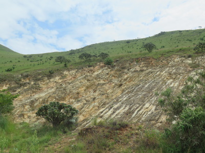
The volcanic and sedimentary rocks are estimated to be around 3.6 billion years old, dating from the Paleoarchean. The geosites show a great variety. Scientists have also found evidence of the largest terrestrial meteor impact event to date near the area.
Community Perspective: There’s a 38km long Geotrail (paved) that you can follow by car, with 11 stops that explain the various geological features. The surrounding landscape is stunning.
Map of Barberton Makhonjwa Mountains
Community Reviews
Svein Elias

Barberton Makhonjwa Mountains world heritage site is in the northeast corner of South Africa bordering northwest Eswatini. There are several reserves in the area and the world heritage site is large and covers a few of them.
The sleepy little town of Barberton, which was founded in the 1880s during a goldrush, is an entrance gate to the geotrail of this site. We started out visiting the museum in the town, but it wasn’t very interesting because it’s focus was golddigging.
We enjoyed this route towards the border of Eswatini. The geotrail is road R40 upwards to the Bulembu border post. The road is paved (asphalt) and can easily be done by a saloon/domestic car. Its 35-40 km and has many stops along the road with information about the earth crust and what is displayed on each stop. Even to an amateur this is interesting, and it’s a very nice journey. The view gets more and more fantastic the higher you go! We found no paths to enter, so there did no hiking. The mountainside is steep so it would have been either steep up or down. In the end (close to the border) the saloon car must return to Barberton.
As we had “another wheels” we wanted to enter Eswatini through the Bulembu border crossing and follow the border south to Ngwenya, but the border post was closed due to covid. The only option left (except to turn around) was to follow the border on the South African side to the Oshoek border crossing. We entered this steep dirt road and descended to the lower area. In total it was a 55 km route in 1 1/2 hours, a partly very bad dirt road not suited for a saloon car.
The Barberton Nature Reserve is a 350 km drive east from Joburg airport. As we arrived from Mapungubwe we had a longer journey of 630 km, an 8-hour drive with a stopover in Graskop. We renounced Krüger national park due to extensive safari earlier on this trip in Tanzania and Malawi.
On our way to Graskop we passed Blyde River Canyon or Motlatse Canyon Provincial Nature Reserve. It is 26 km long and is one of the larger canyons on earth even though it's smaller than Grand Canyon and the Fish River Canyon. Nevertheless, the view is stunning! It literally takes your breath away.
Zoë Sheng
Chinese-Canadian - 12-Feb-19 -

I understand now why there is no buffer zone to this site. Most of the site is on privately owned land and there is no need to protect it with more areas surrounding it. I am actually shocked how this can be listed as WHS but a massive chunk, 20% perhaps, is a private game reserve called Mountainlands.
Coming from the Oshoek border crossing I didn't take the 4x4-only path leading to the Genesis Road. I took the long way around and eventually made it into the core zone. The Genesis road leads you along the border towards the Geotrail but don't expect anything aside from bumps and nice views. There is even a lodge village with a security gate but they are happy to let you through.
The Geotrail completed in 2014 then continues to Barberton. Along the 38km road are 11 spots to park, read a panel and see the rocks for yourself. Some stops are just lookouts to see the mountains and the valleys. The highlight of these is surely the Lebombo View. Not only is the view fantastic, there is a panel for each different rock as seen at the individual spots, e.g. tidal sandstone. Plus there is a toilet (and it encourages going in the fields)!
The area has the oldest most well preserved sequence of volcanic and sedimentary rocks on earth, from time periods 3.2-3.5 billion years ago. With Vredefort Dome, 20% of South Africa's WHS are currently geology related. Add that to the fossil site, rock paintings and a couple of parks listed for cultural reasons, it makes ZA sound very boring on paper. Of course they are not, but the geology sites rank far behind with the others. I think the geotrail is trying to give us an idea of what happened here before and how. The how is not always easily understood. The rocks may contain artifacts of the oldest creatures of earth yet no fossils are visible, so unlike those sites with the “snails” etc you only see the rocks and you can touch anything you want, although you shouldn't touch anything but the examples.
I met a hiker on the way and he confirmed my findings that everything is off-limits aside of staying on the road. He tried to hike the area but people would ask him what he is doing. The private game reservation is probably the biggest shock and they have for sales signs on the fence. If you ever wanted to own a piece of South African world heritage here is your chance.
On the other hand, as beautiful as the park is the main feature for the world heritage listing is seen on the geotrail. The listing is still too recent apparently as there was no UNESCO sign and no plaque along the trail.
The whole trip took less than 3 hours so I didn't stay in Barberton and instead drove on to save time. With the lack of hikes I find the area very lacking of entertainment. Whereas I didn't find it very boring and they are trying hard to make geology interesting, I didn't quite grasp what some of the signs meant and I just find the rock formations interesting. The small sites make it difficult to park if there is another car parked there already, although I didn't run into anyone on the way. Lasty, the scenery is stunning so I have to give it some extra marks. I can't fully recommend it but maybe you can attach it to a visit to Kruger.
Site Info
- Full Name
- Barberton Makhonjwa Mountains
- Unesco ID
- 1575
- Country
- South Africa
- Inscribed
- 2018
- Type
- Natural
- Criteria
-
8
- Categories
- Natural landscape - Mountain
- Link
- By ID
Site History
2018 Advisory Body overruled
IUCN advised Referral
2018 Inscribed
Site Links
Unesco Website
Official Website
In the News
Connections
The site has 9 connections
Damaged
Geography
Human Activity
Timeline
WHS Names
World Heritage Process
Visitors
38 Community Members have visited.
The Plaque
No plaque has been identified yet for this site.