Tanbaly
The Petroglyphs within the Archaeological Landscape of Tanbaly testify to the lives and beliefs of the people of the Central Asian steppe since the Bronze Age.
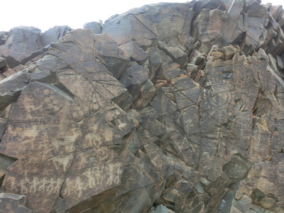
Tanbaly holds large petroglyphs, mostly cut into unsheltered rock faces, that are unique in their iconography. Over 5,000 images across 48 locations have been found. The site also includes ancient settlements, burial sites and sacred sites.
Community Perspective: situated in a remote location, only accessible via private transport. Make sure you or your driver/tour company doesn't confuse it with Tamgaly Tas. The rock engravings are signposted in 7 groups (not all might be open), and can be easily visited in 2 hours. Solivagant’s review zooms in on the cultic complex that they allegedly were part of. Els has provided the most recent overview of what you may expect to find on site.
Map of Tanbaly
Community Reviews
Els Slots

On a map, the Kazakh WHS of Tanbaly (not to be confused with Tamgaly Tas!) doesn’t look to be too far from Almaty, but it takes quite some time to cover the 170km between the two places (we did it in 2h45). I went with a car & driver which I’d hired for the day via Indyguide, and we first had to navigate the busy and chaotic traffic to get out of Almaty. Then there’s a good stretch of highway west and, after the turnoff to the north which is signposted to the Site of Tanbaly, what remains is a B-road with some potholes but little traffic. The only thing you see by the side of the road are large farms, and they keep sheep and horses as livestock. As so often with rock art sites, Tanbaly lies in a remote river canyon that once had special meaning for people living in or passing through the region but lost its significance later on. It’s also the only piece of exposed rock in an area of steppes and offers protection against the sun and wind.
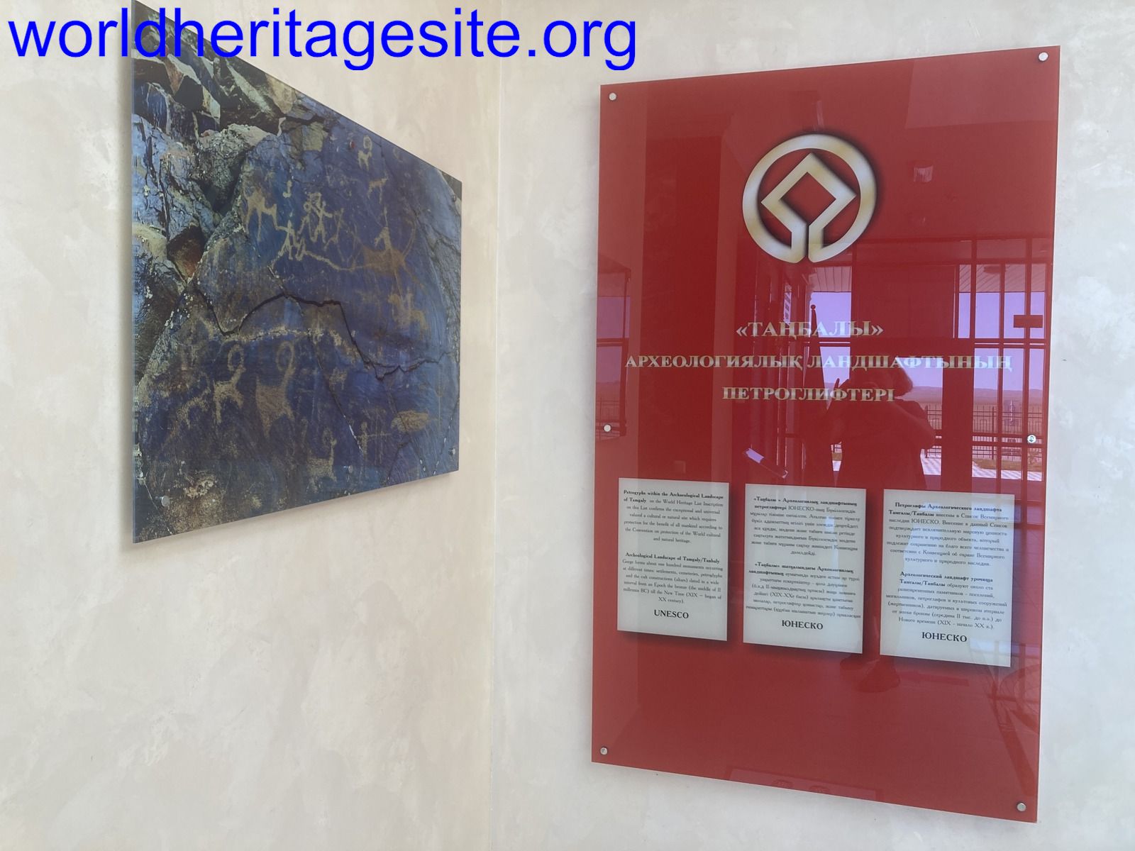
Our first stop was at the museum, which was given a proper building in 2021 and even comes with a museum shop. They show a few findings from the site, such as pottery found in the graves. Otherwise, it is mostly large photographs of the rock art on display. They also explain how they cleared the rocks of graffiti, which has been a real problem at this site in the 1990s when there was no oversight. WH collectors can also find the original WH certificate on a wall inside the museum.
About a kilometre further along the road you enter the fenced reserve where the rock art and associated archaeological sites are. There’s a large parking lot and at the reception area, you must pay the entrance fee of 500 tenge (1 EUR). We were surprised that we were not the only visitors – a large bus was already parked there. It belonged to a group of art students, who were painting ‘en plein air’ at the site for a competition. We found them sitting everywhere with their canvases.
A visit to the site itself is done on foot via well-marked trails. Not all rock panels were open (they have 7) – we did 3, 4, and 5, and watched panel 2 from a viewpoint. Contrary to what I read online beforehand, you do not need a guide and no guides are available at the reception area. I was with a driver/guide who had been there before, but she wasn’t a specialist in the subject. She did know where to look though for the more special engravings such as the pregnant cow, the fighting dog, dancing people and some sun-deities.
I had brought my superzoom camera, which came in handy as the rock art often could be viewed better from a distance than when you were standing right in front of it. The specific kind of rock found here seems very suitable to keep the rock art preserved and the way it was done (chiselling or picketing the objects out of the rock with the use of tools, not carving) seems to be beneficial for the viewing conditions as well. You can see them well and they are not as weather/sunlight dependent as other rock art sites around the world. I especially liked their silvery backgrounds.
The main trail, which takes about 1.5 hours to complete, ends at some Bronze Age burial sites. These are stone ‘boxes’ in the ground (see lower photo). Both adults and children were laid to rest here in crouched positions, and some graves are considered to be cenotaphs (so having had no body at all). A few of the boxes hold interior engravings similar to the rock art.
Overall, I enjoyed my visit - it gets you deep into the Kazakh countryside, the rock art is well-visible and some of it is very old. The site seems well-managed nowadays and there was a pleasant atmosphere with the visiting group of students. We brought our own picnic lunch (there are no restaurants or other amenities in the area) and ate it sitting on one of the benches in the parking lot.
Read more from Els Slots here.
Solivagant

Of the 41 sites currently represented in our “Petroglyphs” Connection only 8, by my count, have been inscribed solely/mainly because of their rock art (Gobustan, Coa/S Verde, Mong Altai, Hail, Alta, Tanum, Valcamonica and Tamgaly). Tamgaly was the 6th of these which we have visited (missing Mong Altai and Hail). Looking back, and trying to discount both the “shock of the new” for the first ones and “travel excess/ennui” for some of the later ones, our view is that Tamgaly emerges pretty well in “interest terms” and significance compared with the others and contains some historically significant representations! It also introduces an archaeological period and culture which is not well known in W Europe/N America possibly because access to it by their archaeologists was cut off for political reasons
As previous reviews have stated, Tamgaly needs to be reached by car, probably from Almaty in a day return trip. We played a slight finesse on this and “saved” a day as we arranged for the vehicle taking us from the Kyrgyz border north of Bishkek to Almaty to take in Tamgaly “on the way”. The turn off north is almost exactly half way between the border and Almaty on National Highway A2 after around 1.5 hours in either direction – Tamgaly then lies another 1 hour along a deteriorating road reaching into ever emptier rolling steppe lands. At the (very) small village of Karabastay there is a visitor centre which neither our guide, archaeologist or driver thought ever opens nowadays – we were told that it only contains photos anyway. I was reminded of the somewhat decrepit Korgalzhyn visitors centre a few days earlier! A couple of kms further on there is a fenced area, a rough car park, a couple of picnic huts, a guard house and 2 rather fine “portaloos” - you have reached “Tamgaly” (except that there seems some debate/confusion as to its name as a number of the signs call in “Tanbaly” in both Cyrillic and Latin script!).
A standard “visit” (we spent a “generous” 2 hours on it with a double circuit) consists of seeing 4 of the 6 groups of petroglyphs as designated by archaeologists and as referred to in literature, by following a reasonably self evident route. The main ones (Titled “Groups II - V”!) lie within a few hundred meters of each other around 500m up the valley from the car park. Group I is passed on the way, but isn’t signed, and group VI is a bit further on. At each group, recently installed, black “marble” notice boards display accurate etched drawings of the rock faces in front of you, together with copies of the main figures – indeed viewing the faces from them with good binoculars was often better than nearer viewing. Good photos of the petroglyphs depend very much on the direction of the sun – they were often better if it wasn’t shining or if a different angle was chosen. Close access to some of the carvings is somewhat ineffectually restricted by ropes – whether you can get close will depend on your guide (we were not restricted) - it appears that all visitors are supposed to have an authorised guide and, presumably, if you arrive without one, then a guard will have to be paid instead? In addition there is a cemetery area with excavated graves. These are a reminder that the full title of the site is “Petroglyphs within the Archaeological Landscape of Tamgaly”. In fact the entire inscribed area contains numerous burial grounds, “Kurgan” burial mounds and remains of areas of settlement, animal enclosures etc. Even though many of these will not be seen it is worth knowing about them in order to understand the overall nature of the site. The graves are of particular importance in helping archaeologists to understand the function of Tamgaly and its cultural environment during the Bronze and Iron ages which is when the majority of the Petroglyphs were made (with the Middle/Late Bronze ages from c1400 BC being of particular significance).
But this was not just a place where pastoral nomads merely passed by at random at various times and filled their spare hours etching pictures on the available rock faces simply for the pleasure of it!! The theory is that the Petroglyphs are situated in a cultic complex – an “Open air temple”. Group IV, in particular, is regarded as the “composition centre” of the whole ensemble. It contains a single panel of 6 (some, including “our” (Russian trained and speaking) archaeologist who (unbeknown to me) was included in our “tour”, say 7) “sun head” images which are believed to represent the “pantheon” of the peoples who carved them. The entire composition portrays a hierarchy of deities, male dancers and women giving birth and, finally at the bottom, “worshippers”. The elevated location of this panel, and the natural amphitheatre surrounding it, is thought to have facilitated its use in rituals, possibly with some personages on the same level as the glyphs and others as “audience” below. “Archaeocoustics” is said to demonstrate the suitability of the site for transmitting sound and the state of the rocks at the base of the composition would seem to show that fires were lit there – so, one could imagine a night time ceremony with flickering flames highlighting the deities and accompanied by sound of rituals! Fanciful? Possibly!
Our archaeologist went further and claimed a link between these depicted deities and those of the Avesta and Rig Veda (Mithra, Indra etc). At which point we move into the realm of the Indo-Aryan migrations and beyond my knowledge and competence! There is no doubt however, that the Tamgaly site is relevant to the debate around migrations, linguistic and belief transfer etc of that time - the burials for instance are assigned to the Andronovo Culture which you could research further if interested. The theory is expounded in detail (782 pages!) in "The Origin of the Indo-Iranians". This tome was published in 2007 by the highly reputable Dutch academic publisher Brill so should have some “credibility” – we are not in Erich von Däniken territory here! The Andronovo story relates to “wider” Kazakhstan and Tamgaly features only en passant, particularly on pages 182/3, 246/7 and figure 56. I briefly quote – “Images of a sun faced character on the … Tamgaly petroglyphs are probably images of the most ancient Indo-Iranian Mithra = Sun God. (.....followed by quotes from the Avesta and Rig Veda )…. All this leads us to interpret the petroglyphs as ancient sanctuaries. Interpreting the semantics of some images and compositions of Andronovo art on the basis of Indo-Iranian mythology is a serious argument in favour of setting the Ayrian homeland in the Steppe”. Figure 56 shows 2 of the “solar faced” characters from Tamgaly including one piece described as a “rock art masterpiece” in the Nomination File - “the solar anthropomorphic image standing on the back of a bull” (Group III). It should be mentioned however that the Nomination file says nothing of this interpretation and assignment of an identified deity to the image!
The other Groups contain further fine examples of petroglyph art – we particularly liked the image in Group III of a calf inside a cow which is also described as a “masterpiece” in the Nomination File (Photo). There are further “Sun men” together with a wide range of animals - camels, horses, deer etc and drawings of human sexual intercourse. LP says that there are also depictions of sexual relations between men and goats – but we didn’t see them and they weren’t pointed out! I thought back to the exhibition called “Sexo in Piedra” which we had seen in the Atapuerca museum a couple of years ago! (See my review). Look out also for the Bronze Age chariot in Group V – the earliest examples of chariots in the World have been found in Andronovo period graves.
The condition of the petroglyphs is a matter for concern. The base rock is sandstone whose flat surface has, in the right orientation and conditions, developed a black surface patina from the sun over the centuries (Called “Desert Sunburn”!). In some examples the artist has deliberately used this for effect by differentially clearing it. The problem is that the rock foliates very easily – primarily from water and frost but also from damage by humans. We were told that vibration has been minimised by keeping the car park well away and also that the area was used by Soviet tanks which shook the rocks. I haven’t been able to verify this so it might be a Kazakh invention! Group IV is particularly a problem with large cracks and separation taking place. I wouldn’t be surprised if, in future years, it will be found necessary to erect a cover and maybe even glass in front. It will also be noted that our favourite cow and calf has lost part of the head and forelegs .
Regarding Tamgaly’s inscribed criteria - Kazakhstan nominated it for i, ii, iii, iv and v. The AB evaluation would seem to indicate that ICOMOS rejected ii, iv and v but accepted i and iii. It did NOT however like the lack of a Management Plan and proposed “Referral”. We have no record of discussions at the 2004 WHC but the recommendation was overturned and the site was inscribed SOLELY on Criterion iii!! What nonsense – its inscription should clearly include Criterion i along with those at Coa and Tanum!!!
Here are 2 other links which anyone interested in discovering more about Tamgaly might find useful
a. This, solely about Tamgaly, has some nice line drawings of the figures, which, given the difficulty of identifying some of them in field conditions, might be of use to anyone going/having been – “The Rock Art of Tamgaly”
b. This also covers Tamgaly in some detail but unfortunately the only version I can find only has the text without the “figures” - “Rock Art sites of Central Asia: Documentation, Conservation, Management, Community Participation”
Thomas Buechler

Tamgaly is the most striking site of rock arts in Central Asia; it is located about 125 km northwest of Almaty, and can be reached only by private transportation. There is no public bus going there, or even going to the villages nearby. I organized it with Stantours, the driver/tourguide (ask for Marat) was very knowledgeable, and is doing this trip on a weekly basis during the tourist season in summer.It is probably a good idea to travel with other people to reduce costs. To rent a car is another option, but you wont have a guide to explain the site. The total number of rock drawings is about 5,000, mainly scenes of goats, horses, warriors, animal sacrifices, and images representing the worshipped sun and their gods; there is even an erotic scene, most probably the first pornographic rock art worldwide, as most of the petroglyphs were made in the Bronze age about 3000 years ago. There is also a scene of dancing men with a woman giving birth. Some stones do have graffitis, unfortunately, or rocks were destroyed by human beings, and carried away. Others show signs of cracks, caused maybe by extreme differences in temperature, frost weathering, or by earthquakes that often occur in this region. The rock engravings are signposted in 5 groups, and can be easily visited in 2 hours. A few steps away, there is also a burial ground of the Turkic period which shows both mass burial, probably of a family with children, and single chamber. Tamgaly was discovered by Anna Maksimova in 1957, and together with some other great archeologists, they researched the rock engravings in the years to come. The site is now guarded, some signboards have been put up with explanations, and it is possible to be accompanied by one of the guards for a few Euros tip.
Brian Searwar
I visited the site at Tamgaly in October, 2005. There is very little security there and one spot looked as if someone had tried to cut one of the petroglyphs out of the rock-face. There was one soldier on guard at the site and that day we saw nobody else as we travelled to the site and returned to Almaty. It is fairly isolated. There was no description at the site except for a few old Russian signs. Things may have changed since then and I would like to know if it's a little more visitor-friendly. There was no entry fee and even my driver had trouble finding the place....he actually got lost a couple times along the way. The rock art is interesting but without a guidebook or a knowledgeable interpreter, it was hard to figure out what it all meant.
Community Rating
Site Info
- Full Name
- Petroglyphs of the Archaeological Landscape of Tanbaly
- Unesco ID
- 1145
- Country
- Kazakhstan
- Inscribed
- 2004
- Type
- Cultural
- Criteria
-
3
- Categories
- Archaeological site - Rock Art Cultural Landscape - Relict
- Link
- By ID
Site History
2021 Name change
From "Petroglyphs within the Archaeological Landscape of Tamgaly" to "Petroglyphs of the Archaeological Landscape of Tanbaly"
2004 Advisory Body overruled
Referral was advised, because of lacking Management Plan
2004 Inscribed
Site Links
Unesco Website
Official Website
Related
Connections
The site has 15 connections
Constructions
Ecology
Geography
History
Human Activity
Timeline
WHS Names
World Heritage Process
Visitors
53 Community Members have visited.
The Plaque
 (photo by Els)
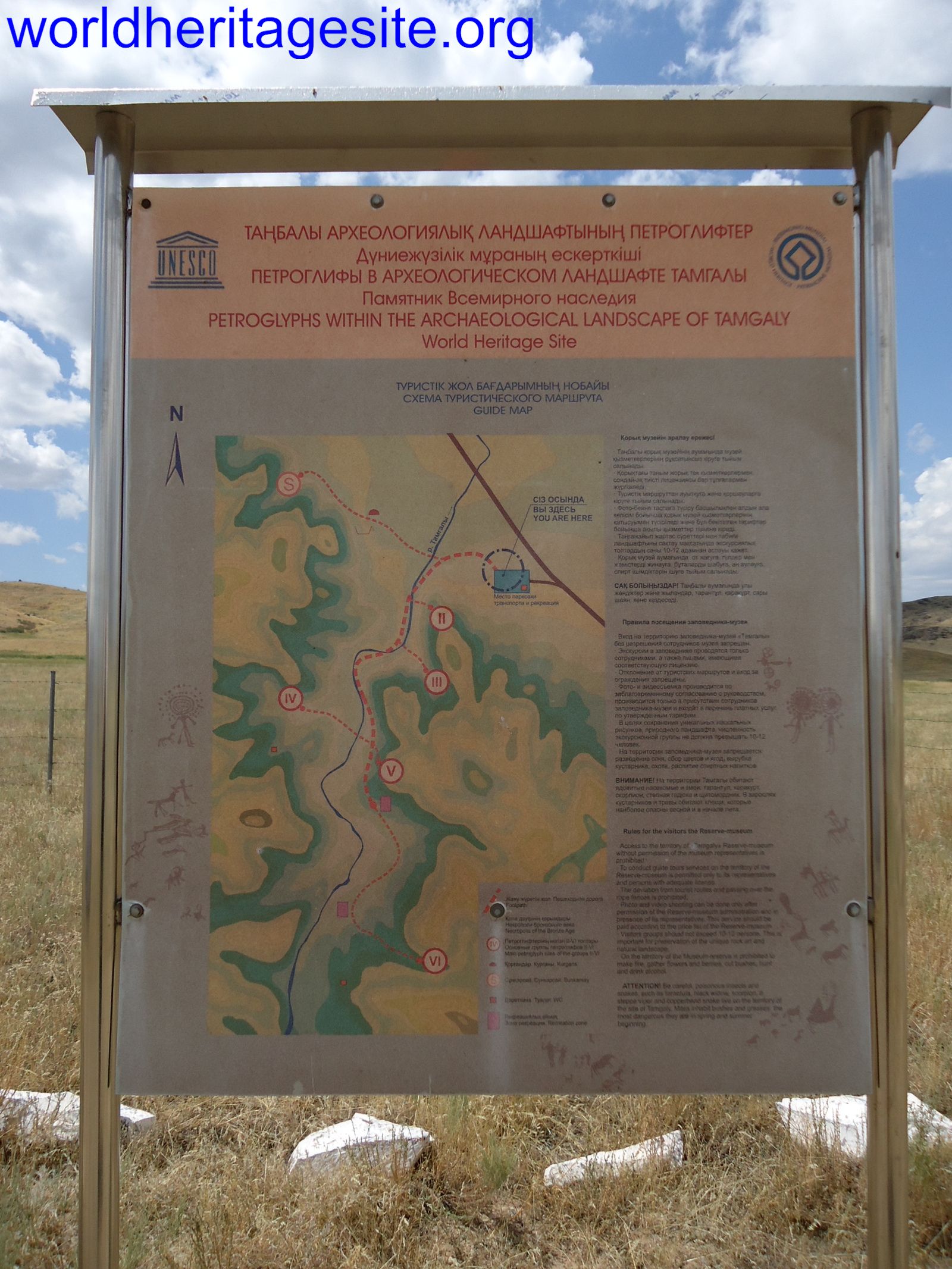 (photo by Jarek)