Alejandro de Humboldt National Park
Alejandro de Humboldt National Park covers a remnant forested mountain ecosystem that is unparalleled in the Insular Caribbean.
This coastal landscape is crossed by many rivers. The park has a high biodiversity, with high numbers of endemic flora, and vertebrates and invertebrates. Its diverse marine species include the West Indian Manatee.
Community Perspective: The park can be visited from the town of Baracoa, where guided tours are available. Inside the park, you can hike or go on a boat trip. You’ll find a gorgeous environment with tropical flora everywhere around you.
Map of Alejandro de Humboldt National Park
Community Reviews
Triath

Visited in January 2023.
The park is the main center of endemic species (and all kinds, both flora and fauna) in Cuba, and in general the largest ecosystem of rainforests in the Caribbean region.
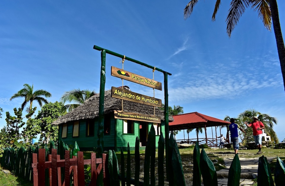
It is located on the eastern edge of the island, near the city of Baracoa, with the foundation of which European colonization began here. Getting there is not so difficult, first you need to get from Santiago de Cuba to Baracoa. Initially, I planned to book a tour to the park from there, but the owners of Airbnb flat convinced me that there was no point in this, it was easier to take a taxi to the park and back. The road is very bumpy, you have to shake quite a bit.
In the visitor center, you can choose one of several routes that are most suitable in terms of difficulty and duration, you must go with a ranger. Our small group got a combined option, we went along the Loma de Piedra trail, it is 8 km long hike, we only had three hours, and the ranger just led us along part of the route during this time.
But we managed to climb to the top of the mountain (only 1110 km), from where a wonderful view of Taco Bay opens up
The soil is red, there is a lot of iron and other minerals, which leads to the appearance of many endemic species in the park. For me, a small joy was to see a chameleon that changed color in the natural environment for the first time in my life. Maybe not endemic, but still a pleasant encounter.
Alexander Barabanov

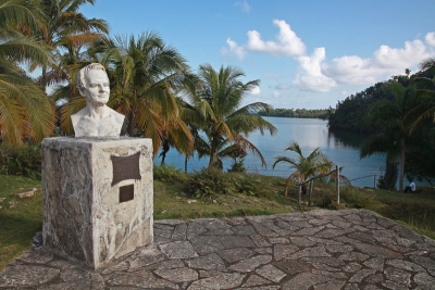
Visited this site in May 2018. There was still very dirty road from Baracoa, which took us over 1 hour to cover 30 km. Parque Nacional Alejandro de Humboldt, covering 707 square km, is famous for its richest fauna in the Caribbean with many endemic wildlife species. The visitor center is located directly on the main road, with some basic information, bust of Humboldt and excellent view over the moon-shaped lagoon. There are 1,200 different species of animals and 1,000 species of plants in the park, 70-80% of them are endemic.
At the time of research, there were three available guided trails, except longest 3.5-day trail and Bahia de Taco trail due to the absence of boats to cross the river. We paid 10 CUCs for two of us and decided to do a boat trip around lagoon with the guide Junior. The boat was completely hand pulled by Junior, as they do not use engines in order to minimize damage to the park. We did a circle around lagoon, visiting mangrove forest, a number of hummingbird nests and enjoying beautiful views back to the shores. This was a very pleasant boat trip followed by a lunch in the family suggested by the guide. The further 20-km stretch of the road to Moa is still dirt and improves around dirt nickel plant only.
Martina Rúčková
Visited in January 2013. The last part of our journey through Cuba was the historically first town on the island, Baracoa. It's the base from which you can easily get to the Alejandro de Humboldt National Park. There are plenty of options on how to visit this site, we chose to take part in a guided tour that included 4 hour long trek around the National park. The price was reasonable, the guide waits you in city centre with bus at hand. The only downside of the tour is getting there, as the road is very rickety indeed, you will have to endure an hour and half of being shaken to your core.
Once you get there, though, it's a different story: tropical flora everywhere around you, many trees and loads of greens that make even the heat of the day much more bearable. There are many curious examples of local fauna, such as tiny frog Iberica, wild hogs with their young piglets and large millipedes. Our guide was very entertaining and made sure we saw most of what could have been seen. The hike is an easy one, apart from first ascend you won't get much elevation. There's a gorgeous lake with a waterfall at the end of the hike, you get to enjoy a soak. Sensible shoes are a neccessity as the red clay on some parts of the trail gets extremely slippery and wet and some shallow river crossings are required.
Site Info
- Full Name
- Alejandro de Humboldt National Park
- Unesco ID
- 839
- Country
- Cuba
- Inscribed
- 2001
- Type
- Natural
- Criteria
-
9 10
- Categories
- Natural landscape - Karst landscapes and caves Wildlife habitat - Flora
- Link
- By ID
Site History
2001 Revision
Successor to former TWHS NR of Terrestrial Molluscs (1997)
2001 Inscribed
1999 Deferred
Bureau - For new protection and boundary definition law
Site Links
Unesco Website
Official Website
Related
Connections
The site has 25 connections
Ecology
Geography
Human Activity
Timeline
WHS Names
WHS on Other Lists
Visitors
40 Community Members have visited.