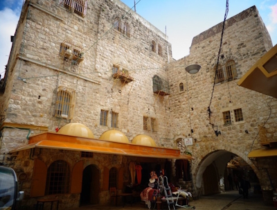
Ahmadabad
The Historic City of Ahmadabad is a 15th-century city especially known for its multicultural character.
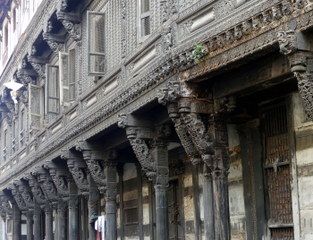
Islamic elements are mixed with Hindu and Jain heritage. The specific style can be seen in the city's religious buildings and domestic wooden architecture. Further notable are its clusters of gated streets (pol), which belong to families of a particular group, linked by caste, profession, or religion. The city is surrounded by a wall.
Community Perspective: Ahmedabad used to be a very dusty and very dirty city, but according to Carlo things have changed a lot for the better since 2022. Several reviewers used the Heritage Walk Ahmedabad to get a grip on the historic elements. Solivagant and Carlo highlight a few structures of interest to explore on your own, while Joel recommends the Gandhi Ashram across the river from the Old City.
Aphrodisias
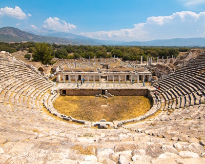
Aphrodisias is an archaeological site that covers the remains of the ancient town with the Temple of Aphrodite and the town’s marble quarries.
The site is representative of the expansion of Hellenistic culture in southwestern Anatolia. The town has other notable monuments such as the theatre, market square, auditorium, public baths and stadium. High-quality marble was quarried a few km away and turned into sculptures in the workshops of Aphrodisias.
Community Perspective: You may already have reached your limits on seeing Classical ruins, but Aphrodisias is ‘different’. It has a good museum and examples of many sculptures that the site is known for. The Tetrapylon and Stadium are worth checking out too.
Asmara
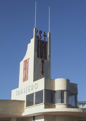
Asmara: A Modernist African City is an Italian-planned colonial city based on early modernist and rationalist architecture.
The urban ensemble was designed during several stages of development on an orthogonal grid plan with diagonal axes. The city was divided into quarters following the principles of racial segregation. During the short fascist period of 1935-1941 the city received its distinct public buildings, which mostly have survived intact since then and keep being part of the Eritrean identity.
Community Perspective: both reviewers so far enjoyed the overall atmosphere of Asmara, but while the freedom of movement for the foreign tourist seems to have improved since 2006, the 2020 review reports that the state of repair of the Art Deco buildings is worsening.
Caves and Ice Age Art
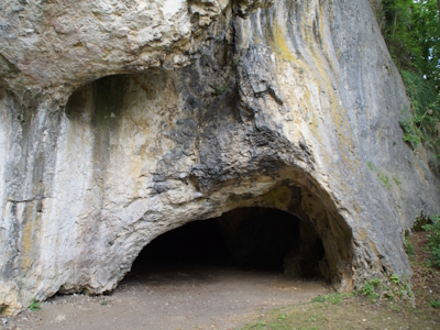
The Caves and Ice Age Art in the Swabian Jura comprise archaeological sites from the Aurignacian period where stone tools, figurative art and early musical instruments have been found.
These six caves in the Ach Valley and along the Lone River have produced evidence of the presence of modern humans who arrived in Europe some 43,000 years ago. The discovered objects were carved from various materials, including mammoth ivory. They include the figurines of the ‘Venus of Hohle Fels’ and the ‘Lion Man’.
Community Perspective: The findings were amazing, but unfortunately they are moveable and have been shipped to museums long ago. A visit won’t be complete without a visit to one of those – the Urgeschichtliches Museum in Blaubeuren is recommended. Among the actual caves, Hohle Fels is the most impressive; Hubert gives a good overview of them all. Nan has described how to get around the area on public transport and Clyde provided an itinerary by car.
Hebron/Al-Khalil Old Town
Hebron/Al-Khalil Old Town is a well-preserved urban fabric that developed during the Mamluk and early Ottoman periods.
The town developed around the Cave of the Patriarchs / Sanctuary of Abraham / Ibrahimi Mosque, a compound dating to over 2,000 years ago and associated with the Holy Books Torah, Bible and Quran. It is a site of pilgrimage for the three monotheistic religions: Judaism, Christianity and Islam.
Community Perspective: This lies in an area under Israeli control. There are 2 entrances to the compound at opposite sides, one for Jews and one for Muslims. People from other religions are allowed to enter from both sides, and you’d do so “for religion or curiosity”, it’s not an “architectural experience”. The surrounding area “is as dead as an abandoned gold rush town on the West Coast”.
Kujataa
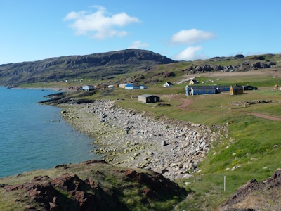
Kujataa Greenland: Norse and Inuit Farming at the Edge of the Ice Cap represents farming and marine hunting cultures adapted to life in the Arctic.
The cultural landscape has features such as archaeological sites, agricultural lands and sheep farms. They include elements belonging to the Norse Greenlandic culture, the first emigrants from Europe to settle here and introduce farming, and to the Thule Inuit culture.
Community Perspective: both reviewers so far described a visit to the “beefed up” former Norse settlements Bratthalid and Gardar, located not far from the international airport of Narsarsuaq.
Kulangsu
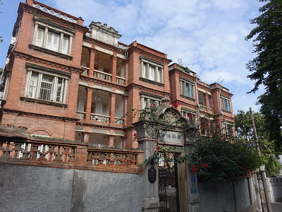
Kulangsu: A Historic International Settlement covers an island where Chinese, Southeast Asian and European architectural and cultural values came together.
Foreign missionaries, diplomats and workers lived on Kulangsu while working in the larger city of Xiamen across the strait. They were instrumental in introducing modern Western culture and technology to China in the late 19th and early 20th centuries. The fusion of cultures also resulted in a new architectural style: Amoy Deco.
Community Perspective: Els has written a comprehensive overview of a 3-hour visit to the island, where the exteriors of the historic buildings stand out.
Lake District
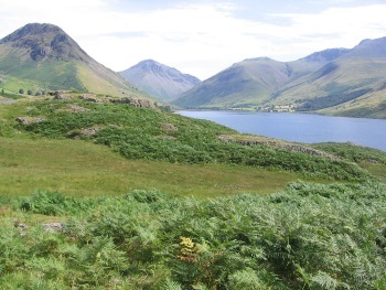
The English Lake District is a cultural landscape shaped by Ice Age glaciers where farming and sheep grazing have defined the land.
It is a mountainous area of great beauty, that has inspired painters and writers since the 18th century. It has the highest peak in England, 13 narrow valleys, 16 lakes of glacial origin and woodlands.
Community Perspective: the landscape can be lovely, but parts are “insanely touristy” (Windermere, Keswick). The quieter places are good for birding and hiking.
Landscapes of Dauria

The Landscapes of Dauria comprise undisturbed and diverse examples of Eurasian steppe with their characteristic wildlife.
The area, which is composed of four reserves in Russia and Mongolia, holds many lakes and wetlands. It is an important breeding ground for three crane species and a breeding and resting place for millions of migrating birds along the East Asian-Australasian Flyway. It also supports the annual migration route of the Mongolian Gazelle.
Community Perspective: Martina has been the only one to review this so far, describing a visit to Adon Chelon. She approached from the Russian side, where most parts need a permit secured well in advance.
Los Alerces National Park
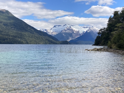
Los Alerces National Park is a visually stunning Andean landscape moulded by glaciations and covered by lakes and temperate forests.
The forests include the best-conserved pockets of the endemic and globally endangered Alerce trees - the second-longest living tree species in the world. The largest and oldest tree here is nearly 60 metres tall and approximately 2,600 years old.
Community Perspective: Access to the park on public transport outside of the high season can be tricky, as testified by Nan. The disadvantage of the high season (January/February) on the other hand is that excursions can get fully booked, as Frédéric noticed. But you can always do a satisfying hike and see an Alerce tree. Timonator stayed overnight.
Mbanza Kongo

Mbanza Kongo, Vestiges of the Capital of the former Kingdom of Kongo, represents the political and religious centre of a vast African kingdom that was transformed by the arrival of the Portuguese in the late 15th century.
The site (now a town of some 175,000 inhabitants) is located on a plateau. It comprises both archaeological remains of the precolonial period as well as colonial structures – often overlapping each other. The Kingdom of Kongo has strong intangible links with the slave trade and the early conversion of African kings to the Catholic religion (with a Cathedral and Jesuit College in place from the early 17th century).
Community Perspective: this site has been unreviewed so far.
Okinoshima Island
The Sacred Island of Okinoshima and Associated Sites in the Munakata Region is an early ritual site associated with maritime safety.
From the 4th century on, votive offerings were made here to pray for safety for boats heading to Korea and China to trade. There are a number of taboos and restrictions on visiting Okinoshima, including a ban on women and the prohibition “to speak of anything they have seen or heard on the Island”. The site includes three nearby islets, Koyajima, Mikadobashira and Tenguiwa, and four living places of worship on Kyushu.
Community Perspective: as the entrance to Okinoshima Island is almost fully barred, the reviewers focused on the associated mainland temples. Hetsu-miya Shrine near Fukuoka is the easiest to visit, and Thomas provides public transport info. AC covered two additional locations and managed to get a glimpse of Okinoshima Island from a distance.
Qinghai Hoh Xil

Qinghai Hoh Xil represents the landscapes and biodiversity of the high-altitude Qinghai-Tibetan Plateau.
Temperatures average sub-zero year-round, which has kept it free from modern human influence. Glacial meltwater supplies the many rivers, lakes and marshlands. The site is also important as a calving area and place of seasonal migration of large numbers of Tibetan antelope.
Community Perspective: The G109 highway as well as the Xining - Lhasa train cut right through the core zone, but you won’t see much that way. Zos managed to make a very adventurous entry but still missed out on the Tibetan antelopes.
Sambor Prei Kuk
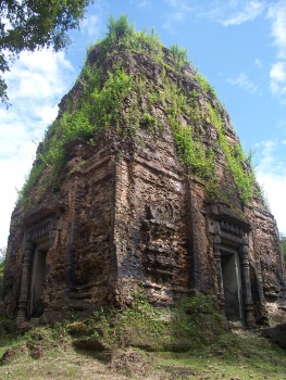
The Temple Zone of Sambor Prei Kuk is an archaeological site of the Pre-Angkorean period.
The site correspondents with Ishanapura, the capital city of the Chenla Empire whose buildings and watercourses influenced later Khmer architecture. 186 fire-brick Hindu temples remain, showing a mix of regional architectural influences and carrying sculptures and important temple inscriptions in the Khmer language. A particular feature is its octagonal-shaped temples, the oldest of their kind in South-East Asia.
Community Perspective: clearly complementary to Angkor, as it provides a good look at pre-Angkorian styles of art and architecture. It does have the same jungle setting with trees growing in and on top of buildings, but due to the smaller crowds (if any) Sambor Prei Kuk is a more intimate experience. Read Frederik’s review for more details on the art styles.
Sviyazhsk

The Assumption Cathedral and Monastery of the town-island of Sviyazhsk covers a Russian-orthodox cathedral renowned for its complete 16th-century cycle of murals.
The monastery dates from the period of Ivan the Terrible, when missionary posts for spreading Christianity in this originally Islamic Tatar region were established. The innovative iconographic program of the monastery’s cathedral shows a fusion of styles from the West (Novgorod, Pskov and Moscow) and the local Volga region.
Community Perspective: Sviyazhsk is an easy half-day trip from Kazan, and you can get there by boat, tour, or car/taxi. It can be hard to get a look at the interior of the Assumption Cathedral and its frescoes, as it seems closed to visitors most of the time.
Taputapuātea

Taputapuātea is a sacral site and cultural land- and seascape on Ra’iatea Island, part of the Society Islands.
The site consists of several archaeological sites and marae (temples). Its main feature is the Taputapuātea marae complex, constructed in the 14th -18th centuries, which is considered the central temple of Eastern Polynesia and has a strong oral tradition connected with it. It was built between land and sea at the end of a peninsula. The marae are of continuing importance to living Polynesian culture.
Community Perspective: Dennis visited already in 1991 and advised coming with a knowledgeable guide.
Tarnowskie Góry Lead-Silver-Zinc Mine
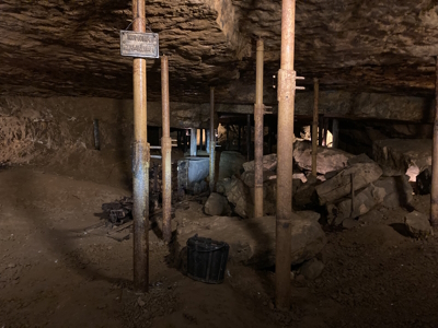
Tarnowskie Góry Lead-Silver-Zinc Mine and its Underground Water Management System represent a historic mining landscape.
Tarnowskie Góry’s lead deposits were used in the smelting of silver gathered from sites in Europe and New Spain in the mid-16th century. A second phase started in the late 18th century during the process of industrialization of Prussia, when it produced mainly zinc. Its hydraulic system for water drainage, necessary because its ore lodes extended horizontally and tended to retain water, is seen as innovative for its time.
Community Perspective: The main guided tour will take you underground, where the excitement lies in a boat tour through the water system. Non-Polish visitors (usually captured on a Polish-speaking tour) often leave with mixed feelings, which are well-described by Solivagant. You can do an additional underground canal boat ride at ‘Black Trout Adit’ – Tsunami has reported on that. Els shared how to get there on public transport.
Valongo Wharf
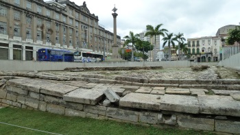
Valongo Wharf Archaeological Site comprises the globally most significant remains of an arrival point of enslaved African persons in the Americas.
The wharf located at Rio de Janeiro’s Jornal do Comércio Square was built from 1811 onwards, and used until the construction of the Empress’ Wharf in 1843. About a quarter of all African American enslaved people to the Americas have arrived here. While its physical remains are modest (fragments of a pavement, a former road), its spiritual associations as a site of conscience for African Americans are strong.
Community Perspective: “The wharf used to jut out into the harbour, but it is now quite a way from the water and there isn't a whole lot to see.” And unless you are “emotionally attached to this place, what you will find is just a very underwhelming and poorly presented 10 minutes easy tick.”
Venetian Works of Defence
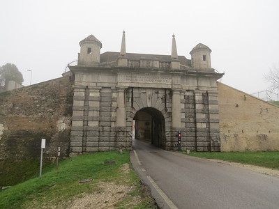
The Venetian Works of Defence Between 16th and 17th centuries: Stato da Terra – Western Stato da Mar represent a defensive network in the Adriatic dating from the historic Republic of Venice.
The bastioned system (‘alla moderna’) was introduced after the increased use of firearms. It protected the Venetian commercial network. The site consists of six components located in Italy, Croatia and Montenegro and spans more than 1000 km.
Community Perspective: all 6 included forts have received a review, they are Palmanova (Els, Ian), Peschiera del Garda (Clyde, Ralf), Sibenik (Alexander, Ilya), Kotor (Jay, Ilya), Bergamo (Ilya, Ralf), and Zadar (Ilya).
Yazd
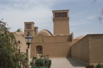
The Historic City of Yazd is a traditional earthen city where life has been adapted to its desert location, most notably via the water system of the qanats.
The earthen buildings have sunken courtyards and underground spaces to deal with the climatic circumstances. Yazd dates back to the Achaemenid era and prospered from trade from the Silk and Spice Roads, which is reflected in religious buildings of diverse religions, bazaars and caravanserais.
Community Perspective: Worth a day’s visit. Solivagant has listed a number of sights around Yazd, although you shouldn’t expect any world class buildings. Michael left with the impression of the colour of mud, as all the buildings are the same colours as the surrounding desert, and Jean enjoyed that it’s human-sized.
ǂKhomani Cultural Landscape

The ǂKhomani Cultural Landscape is a vast desert area associated with ǂKhomani San culture since the Stone Age.
The area amongst the sand dunes of the Kalahari Gemsbok National Park lies in a hostile, dry environment plagued by predators. It was used by the indigenous ǂKhomani San hunter-gatherers for water and (medicinal) plants. The tangible remains include archeological sites and graves.
Community Perspective: reviewers regret that natural aspects weren’t part of the nomination, as Kalahari Gemsbok (the South African part of Kgalagadi Transfrontier Park) is a great park. Walter and Solivagant were relatively early visitors (1997 and 1998 respectively), when the access roads were still mostly gravel and the cultural aspects were not yet much emphasized. Tamas recently deep-dived into the cultural aspects on a 2-day tour.
Extended Sites in 2017
Bauhaus Sites
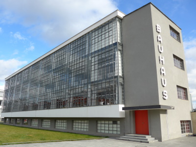
Bauhaus and its Sites in Weimar, Dessau and Bernau represent the most prominent examples of the Bauhaus architectural school, which was the birthplace of Classical Modernism.
The "Staatliche Bauhaus" was responsible for the radical renewal of architecture and design. These seven (groups of) buildings represent both their initial phase in Weimar under Walter Gropius, and the second (and more successful) phase out of Dessau (with Hannes Meyer and Ludwig Mies van der Rohe). The Bauhaus building, made out of concrete, glass and steel, is a landmark in 20th-century architecture.
Community Perspective: This has received glowing reviews from the modern architecture-loving part of the WH community (Ian even wrote 3 reviews!). Taking a guided tour of the Bauhaus building is a good start to understanding their ideas.
Ian Cade UK - 01-May-05

If your idea of a good World Heritage site is a historic city centre, then this is perhaps not the best place to visit as arriving from the train station the Bauhaus itself could easily be mistaken for any other municipal building pretty much anywhere in the world. However if like me you have a keen interest in modern architecture or design this is less a visit and more a pilgrimage.
The main building of the Bauhaus was designed by Walter Gropius after the school was forced to relocate due to political changes in Wiemar. Gropius is one of the key architects of the twentieth century and this building is his masterpiece
Read OnPrimeval Beech Forests
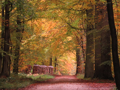
The Ancient and Primeval Beech Forests of the Carpathians and Other Regions of Europe show the expansion and genetic adaptability of the European beech since the last Ice Age.
They comprise the largest remaining forests of the European beech ('Fagus sylvatica') across 18 countries. They also hold the largest and tallest beech specimens in the world. The European beech is a very adaptable species and it is spread across areas of different altitudinal zones, with different climatic and geological conditions.
Community Perspective: “I would like this beech forest madness to stop.” – this cry from Philipp seems to sum up the verdict on this WHS nicely; Caspar also shares some philosophical insights on the matter. But reviewers keep being drawn to its many locations. An inventory of the reviews results in 14 parks ‘ticked’: Vihorlat (Slova) – Els, John, Petteri, Matejicek; Stuzica (Slova) – Jarek, John; Hainich (Ger) – Hubert, John, Ian, Nan, Adrian; Kellerwald (Ger) – Peter, Clyde, Solivagant, John, Nan, Adrian; Grumsin (Ger) – Boj, Tsunami, Adrian; Jasmund (Ger) – Thijs, John, Michael, Matejicek, Nan, Tsunami, Adrian; Serrahn (Ger) – Adrian; Sonian Forest (Bel) – Els, Caspar; Monte Cimino (Ita) – Matejicek; Foresta Umbra (Ita) – Matejicek; Bieszcziady (Pol) – Matejicek; Jizera (Cz) - Matejicek; Bettlachberg (Swi) – Philipp, Adrian; Mavrovo (NMac) – Chris.
Els Slots The Netherlands - 26-May-08

In preparation for my visit, I had a difficult time finding any practical information about the nominated properties in Slovakia. My guidebook has nothing of any value on them but does include a handy map called 'Snina wooden churches' that covers the same area. The IUCN evaluation holds a shady map, which seems to point out only 3 properties on the Slovak side instead of 4. A better bet for maps is the Slovak/Ukrainian nomination dossier. I also found a regional website that has information about villages and parks. It describes access to the Vihorlat Protected Landscape via the village of Zemplínske Hámre. So I turn this route into the goal for myself today, possibly (weather and other circumstances permitting) with a walk to Morské Oko lake.
Read OnStrasbourg
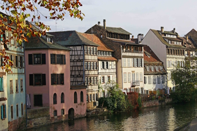
Strasbourg, Grande-île and Neustadt comprise the medieval historic centre of Strasbourg including its Cathedral and its German-built New Town.
The free city of Strasbourg was an important commercial centre in the Middle Ages. Its urban landscape is typical of the Rhineland and shows both French and Germanic influences. The Gothic Cathedral is the center of this city organized around rivers and canals, with an additional network of (post-)medieval streets adorned by timber-framed buildings.
Community Perspective: You’d best spend your time here just wandering around. The German-developed, late 19th century New Town, located across the river from the medieval city, sharply contrasts with the rest of the core zone and divides opinions.
Ian Cade UK - 01-May-05

I have to admit perhaps my favourite places to visit are these medium sized European cities, and Strasbourg was definitely well worth a weekend break.
The city centre is on an Island (Grande Isle) and its main assets are two fold, hopefully shown in the photo. Firstly rows of half-timbered houses overlooking cobbled streets/ waterways. Secondly the massive Gothic Cathedral. It was regarded by Goethe as the finest Cathedral in Europe, and its main edifice certainly ranks up there with the best. Inside is a fine astronomical clock, which like every other one I have seen is achingly under whelming to watch in motion on the hour.
Read OnW-Arly-Pendjari Complex
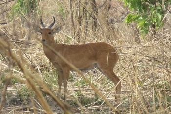
The W-Arly-Pendjari Complex comprises a savanna landscape recognized for its biodiversity of birds, fish and plants.
These three contiguous parks are located within the Volta River basin at a transition zone between savannah and woodlands, with both terrestrial and aquatic ecosystems. The area is a refuge for species that have mostly disappeared from the rest of West Africa, such as elephants, wild dogs, lion, leopard, cheetah and manatee.
Community Perspective: you won’t find wildlife in the innumerable quantities of the East African parks, but at least in visible herds. The facilities suffer from underinvestment and the border area with and in Burkina Faso is considered unsafe. Tamas made an adventurous approach to the part in Niger (Park ‘W’) as did Michael, while Solivagant and Chris focused on Pendjari in Benin.
Szucs Tamas Hungary - 31-Dec-12

West Africa is not the right place to see animals. In most of the West African parks you can see practically nothing but the landscape. This was the case in Mole National Park of Ghana, where the most interesting animals we have seen were ants - forming a long strip on a lakeshore. Park W is much more difficult to reach than Mole, but as a reward, you can see some wildlife. Not comparable with the great East African parks, but at least there you can say, you were not sitting in a 4wd for days in vane. Because getting to the park is definitely not easy. First somehow you have to get to Niger -that can be a challenge itself. We tried to apply for a visa in Berlin, but were refused, so applied again in Accra where some "extra processing fee" helped us to get the visa of our dreams
Read On