Aasivissuit - Nipisat
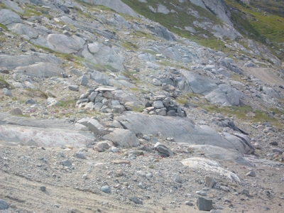
Aasivissuit-Nipisat, Inuit Hunting Ground between Ice and Sea, is a cultural landscape shaped by the seasonal migration of the Inuit.
This Arctic landscape holds key locations along routes that were used from coast to inland in summer and then back again in late autumn. They are archaeological sites and settlements that are still in use. This landscape was settled about 4,200 years ago, with (Palaeo-)Inuit sustaining themselves by marine and terrestrial hunting.
Community Perspective: to put your feet in the area, it only needs participation in a trip to the glacier from Kangerlussuaq – “you drive past/through them but you don't really see anything spectacular” as Zoë sums it up. Michael explored the area on his bike and managed to find a WHS information plaque. The 7 named key locations (settlements, summer camps) so far have been unreviewed.
Al-Ahsa Oasis
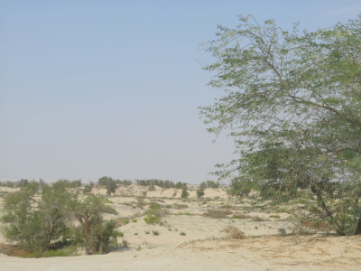
Al-Ahsa Oasis, an Evolving Cultural Landscape, is one of the largest natural agricultural palm oases in the world.
Al-Ahsa has been inhabited since prehistoric times, due to its abundance of water in an otherwise arid region. The water was distributed through a network of canals in the open air. The 12 inscribed locations comprise date palm groves, castles, urban centers, archaeological sites, villages, Jawatha mosque and Al-Asfar Lake.
Community Perspective: the reviewers so far found some of the components still under construction and others not findable at all. Martina declared the mountain Jabal Al-Qarah in the city of Al Hofuf the most interesting stop, while it would be hard to distill anything positive from Zoë’s contribution.
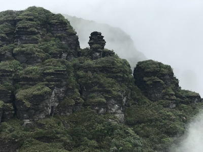
Barberton Makhonjwa Mountains
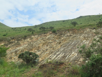
Barberton Makhonjwa Mountains contain some of the oldest exposed parts of the Earth’s crust, providing a wealth of information about early Earth.
The volcanic and sedimentary rocks are estimated to be around 3.6 billion years old, dating from the Paleoarchean. The geosites show a great variety. Scientists have also found evidence of the largest terrestrial meteor impact event to date near the area.
Community Perspective: There’s a 38km long Geotrail (paved) that you can follow by car, with 11 stops that explain the various geological features. The surrounding landscape is stunning.
Chaîne des Puys
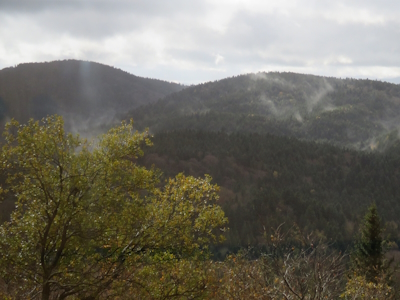
The Chaîne des Puys - Limagne fault tectonic arena shows a number of geological features caused by a continental break-up.
This about 40km long segment of the West European Rift shows the effects of continental break-up on the landscape, such as the Chaîne des Puys volcanoes and the inverted relief of the Montagne de la Serre. The site has been an important place for studying classical geological processes since the 18th century.
Community Perspective: The Puy de Dôme is an easily accessible part of this site, with good overlooks over the landscape dotted with some 80 small dormant volcanoes. Hubert did his best to cover some additional noteworthy components.
Chiribiquete National Park

Chiribiquete National Park - "The Maloca of the Jaguar" is a very large and inaccessible national park in the Amazon rainforest, known for its tepuis and painted rock shelters.
The tepui or tabletop setting has led to a high level of endemism, with numbers expected to rise when more research will be done in the future. The park is home to a healthy population of jaguar and other vulnerable mammal species. It also protects flooded forests called “Purus Varze”. Sixty rock shelters with ca. 75,000 paintings are present at the foot of the tepuis. The depicted scenes are linked to a purported cult of the jaguar and their ceremonial use extends into the present day by isolated indigenous communities.
Community Perspective: tourism into the park is not allowed because of the “potential threat to the rights .. of the voluntarily isolated and uncontacted indigenous peoples” (IUCN Outlook 2020). The only way to catch a glimpse is “through flyovers by small planes on pre-arranged flight paths that are designed to be far away from known human settlements”. Zoë reports about a visit to an area near San José del Guaviare with similar (but uninscribed) rock art.
Fanjingshan
Fanjingshan is an isolated mountain landscape with a high degree of endemism.
The property’s geologic and climatic characteristics have shaped its flora which behaves as if it were on an island. The rugged terrain of primary forest contains many endangered floral and fauna species, such as the Guizhou snub-nosed monkey. Fanjingshan’s wet conditions also result in an extraordinary richness of bryophytes (mosses).
Community Perspective: Zoë definitely recommends a visit and has written a comprehensive review about what to expect (spoiler alert: you’re unlikely to encounter an endangered Guizhou monkey).
Göbekli Tepe

Göbekli Tepe comprises the oldest known monumental megalithic structures in the world.
The archaeological site of a community in transition from hunting-gathering to farming consists of a tell of about 15m in height. From the 10th–9th millennium BCE, circles of massive T-shaped stone pillars were erected here. More than 200 pillars in about 20 circles are currently known through geophysical surveys. The pillars are richly carved with images.
Community Perspective: The site needs proper preparation (watching a few videos or reading some articles mentioned in Solivagant’s review for example) to be understood. The earlier ugly wooden structure covering the remains has now been replaced by a tent that allows some sunlight to come through, and there is a visitor center.
Hedeby and Danevirke
The Archaeological Border Complex of Hedeby and the Danevirke comprises the archeological site of a medieval trading network that existed between Western and Northern Europe.
The Danevirke was a 33km long fortified wall that marked the border between the emerging Danish kingdom and the Frankish Empire. Hedeby was a market town that expanded due to the growing economic power of the Danish Vikings.
Community Perspective: the Viking Museum at Haithabu provides the most comprehensive overview, although its structures are mostly reconstructions as not much of the originals are left beyond the earthworks. Nan provides a local perspective, and Clyde describes a full visit including the Dannewerk museum.
Hidden Christian Sites in the Nagasaki Region
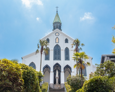
The Hidden Christian Sites in the Nagasaki Region reflect the period from the 17th-19th century when Christianity had to be practiced in secret.
After the introduction of the religion by a Jesuit priest in 1549, many people in the region converted. The Japanese rulers followed with a ban on Christianity (and foreign missionaries), that lasted until 1873. The religious practice however survived in a distinct vernacular version in remote communities.
Community Perspective: Oura Church is an easy ‘tick’ in the center of Nagasaki, and there are more components to be visited in the same general area. Frederik reports on a trip to two coastal communities that hold Ono Church and Shisu Church.
Ivrea
Ivrea, industrial city of the 20th century, was designed as a modern industrial city showing the transition from mechanical to digitalised industrial technologies.
Ivrea was the base of operations for Olivetti, a manufacturer of typewriters, mechanical calculators and, later, computers. Especially Adriano Olivetti in the 1930s developed an interest in architecture and urban planning, and he worked with the best-known Italian architects and town planners of his time. This resulted in industrial and public buildings and a housing plan for workers.
Community Perspective: the state of preservation is far from great and you’ll encounter no-trespassing signs, but there’s a signposted trail with information panels around town. Recently (2023) a new visitor center opened, that has a map of all historic buildings.
Medina Azahara
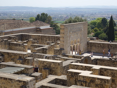
The Caliphate City of Medina Azahara represents the urban planning of the 10th-century Umayyad caliphate in the Islamic West.
Medina Azahara is a ruined city, that lay undiscovered until the beginning of the 20th century. It was a palace-city built by the first Umayyad Caliph of Córdoba, as the symbol of his power. It served as the de facto capital of Al-Andalus. The city included ceremonial reception halls, mosques, administrative and government offices, gardens, a mint, workshops, barracks, residences and baths.
Community Perspective: It took a few years before it fully opened up to tourists – and the Rich Hall only has from Oct 2023 and is still unreviewed. The museum is excellent, but the remains in situ can be disappointing as they are either rubble or visible reconstructions. You have to take a (paid) bus to the archaeological site.
Naumburg Cathedral
The Naumburg Cathedral contains artistic masterpieces of a medieval sculptor and his workshop, known as ‘the Naumburg Master’.
The 13th-century Cathedral shows a combination of architecture, sculptures and painted glass windows. It’s especially renowned for its lifesize polychrome sculptures of the twelve cathedral founders, all created by the Naumburg Master.
Community Perspective: Its scope has been severely limited on the road to the inscription (this was an especially painful one as after 3 times ICOMOS effectively gave up), until only the Cathedral remained. Overall, the reviewers find it worth visiting; it’s a niche site that has been ‘hidden’ for too long in the countryside of the GDR.
Pimachiowin Aki

Pimachiowin Aki is a large forest landscape in the heart of the North American boreal shield that holds sacred meaning for the Anishinaabe First Nations.
Pimachiowin Aki (“Land that gives life”) encompasses three provincial parks: Woodland Caribou and Atikaki Provincial Parks along with Eagle-Snowshoe Conservation Reserve and the ancestral lands of the Anishinaabe First Nations. The Anishinaabe continue to live in this forested area in four small settlements and use its waterways for trapping and fishing. They also hold ceremonies at specific sites. Wildlife in the parks includes Woodland Caribou, Moose, Wolf, and Wolverine.
Community Perspective: Zoë reached the outer edges of the parks and searched for the cultural aspects in Bloodvein. Can gave an overview of the possibilities to access, and kayaked his way in.
Qalhat
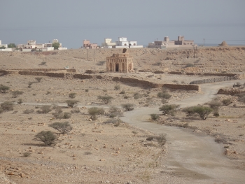
The Ancient City of Qalhat was an important stopping point in the wider Indian Ocean trade network and the second city of the Kingdom of Hormuz.
The site blossomed between the 11th and 16th centuries. Its archaeological remains include the Friday Mosque (Bibi Maryam), necropolises, residences, and workshops. Evidence of trade with China and India has been uncovered.
Community Perspective: most early reviewers were restricted to a view from a parking place on the highway (as the site has been closed for renovation for ages). Clyde was brave and managed to get illegal entry to the remains.
Sansa, Buddhist Mountain Monasteries
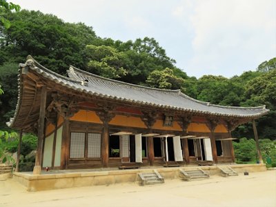
Sansa, Buddhist Mountain Monasteries in Korea, represents the earliest era of Korean Seon Buddhism and its distinctive spiritual practice.
The seven remote monasteries were established in the 7th to 9th centuries. They prospered during the Goryeo Dynasty which established Buddhism as a state religion. The monasteries are still in use as centers of meditation and Buddhist study and have preserved many of their historic structures, objects and documents.
Community Perspective: Five out of the seven included monasteries (all situated in the southern provinces) have been covered by our reviewers: Tongdosa (GabLabCebu), Buseoksa (Kyle), Beopjusa (Kyle, Frederik), Magoksa (Kyle), and Seonamsa (Clyde, Frederik).
Sassanid Archaeological Landscape
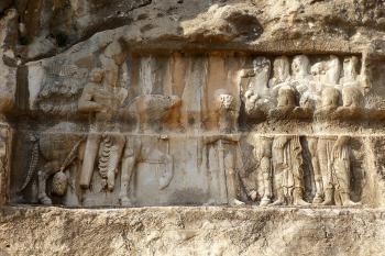
The Sassanid Archaeological Landscape of Fars region covers monumental buildings, inscriptions, and other relevant relics of the three main cities of the Sassanid Empire.
The archaeological sites stand out for their rock carvings and sculptures. The empire also is known for its contribution to the distribution and establishment of Zoroastrianism, and the site includes major Zoroastrian monumental architecture such as the Takht-e Neshin fire temple.
Community Perspective: Solivagant has submitted the only review so far (done so before inscription); he visited two of the ancient cities, Bishapur and Sarvestan, and recommends the bas-reliefs. The "main" location, Firuzabad, so far stays unreviewed.
Tehuacán-Cuicatlán Valley
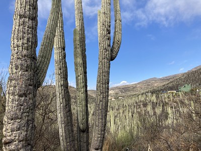
Tehuacán-Cuicatlán Valley: originary habitat of Mesoamerica is a semi-arid area recognized for its remarkable level of biological diversity and precolonial water management system.
Botanically it is of special significance for its 86 species of cacti and the existence of ‘cacti-forests’. The diverse fauna includes threatened amphibian and bird species such as the threatened Green Macaw. The arid conditions led to early plant domestication and the development of water management features.
Community Perspective: The easiest component to visit is the Botanical Garden "Helia Bravo Hollis", where you can see many species of cacti (and even stay overnight, as Clyde did). The surrounding area also shows the ‘cacti-forests’. Sinuhe has described other possibilities as well, and Frédéric did a recommended 3-day tour.
Thimlich Ohinga
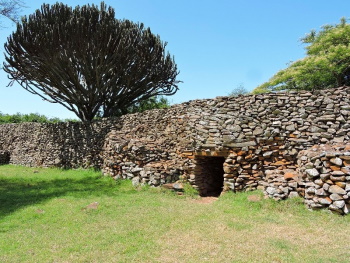
Thimlich Ohinga archaeological site comprises 4 larger fortified settlements that are the best-preserved examples of pure dry stone building in the Lake Victoria Basin.
The dry stone wall enclosures incorporated shared communal settlements (Ohingni) with homesteads, livestock and craft industries. They were founded by the early pastoral communities of the Lake Victoria Basin from the 16th century CE onward.
Community Perspective: “The effort of reaching the site may be greater than the payoff”, but Michael did so anyway – on his bike.
Victorian Gothic and Art Deco Ensembles of Mumbai

The Victorian Gothic & Art Deco Ensembles of Mumbai represent the modernization of Mumbai into a cosmopolitan city by the late 19th century.
The area comprises the urban plan and historic buildings around the open green space of the Oval Maidan. It was created during the two major urban expansions of the city, adding Victorian Gothic public buildings in the late 19th century and Art Deco commercial/private ones in the 1930s. The area also has some interesting Indo-Saracenic and Classical Revival architecture.
Community Perspective: it doesn’t leave any particularly strong memories and reviewers wonder why it hasn’t been made ‘just’ an extension of the CST. Read the nomination dossier to see which notable buildings are included.
Extended Sites in 2018
Central Sikhote-Alin

Central Sikhote-Alin comprises intact forest landscapes in a mountain range in the Russian Far East.
Sikhote-Alin comprises one of the most extraordinary temperate zones in the world, with highly diverse flora and fauna. Species typical of northern taiga (such as reindeer and the brown bear) coexist with tropical species like the Amur tiger and the Himalayan bear.
Community Perspective: The site consists of three protected areas. Martina has described access via Terney, from where she did three hikes. The season here is short, from July to October.
Martina Rúčková Slovakia - 07-Sep-20

Desperate times call for desperate measures. So when Ivan and I got stuck in Russia for a progressively longer and longer time, we started not only revisiting old Russian WHSs, but thought about visiting the new ones too. Not many left, but we did what we could and Ivan planned a week-long trip along regions of Russian Far East.
Having been to Kamchatka and Lena Pillars already, it was Sikhote-Alin Natural reserve that remain to be visited. Your hub will be Vladivostok. From there, there are three ways of getting in and out of Terney, a gateway to the park. One is comfortable, another two are weatherproof. September is said to be the best weatherwise, so we chose the comfortable one - with a small De Havilland Canada DHC-6 Twin Otter aircraft on a daily line between Vladivostok and Terney, operated by Aurora Airlines, a subsidiary of Aeroflot. Prices are subsidized by the government and a plane ticket (2600 rubles) is actually cheaper than 14-hour bus ride (3000 rubles). The bus to and from Vladivostok departs twice a day: in the morning and in the evening
Read On