Bali Subak system
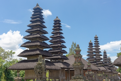
The Cultural Landscape of Bali Province: the Subak System as a Manifestation of the Tri Hita Karana Philosophy comprises five sets of rice terraces and associated water temples.
The Subak System refers to the thousand-year-old self-governing associations of farmers centered around water temples who share the use of irrigation water for their rice fields. Water from volcanic lakes is diverted through rivers and channels to end up in the rice terraces. Ceremonies associated with the temples promote a harmonious relationship with the natural and spiritual world.
Community Perspective: Frederik visited Taman Ayun Temple, Subak Landscape of Pekerisan and Lake Batur, while Frederic additionally covered Catur Angga Batukaru. Clyde even saw all 5 components over a week and shares his favourite spots.
Bassari Country
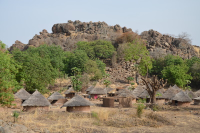
Bassari Country: Bassari, Fula and Bedik Cultural Landscapes represents an isolated, multicultural society of communities who practice traditional agriculture.
A mix of Bassari, Fula and Bedik peoples live in agricultural villages that were settled by several waves of migrations from probably the 11th-13th century on. The villages are located in a hilly, difficult-to-access landscape.
Community Perspective: the villages are hard to reach, but Stanislaw managed to visit three and recommends Bedik Bandafassi.
Bethlehem
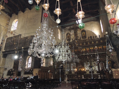
“Birthplace of Jesus: the Church of the Nativity and the Pilgrimage route, Bethlehem” is an early church and major Christian pilgrimage destination.
The Church of the Nativity was built over a cave that since the 2nd century is considered to have been the birthplace of Jesus. The present church dates from the mid-6th century and is the oldest Christian church still in daily use. The complex also consists of a number of Latin, Greek Orthodox, Franciscan and Armenian Convents and churches, and a small part of the Pilgrimage Route from Jerusalem, which is celebrated during the yearly Christmas ceremonies.
Community Perspective: Dozens of buses and tour groups visit this every day, so be ready to queue up to get a glimpse of the actual birthspot. The church itself is “not necessarily in the best state of preservation or aesthetics”.
Çatalhöyük
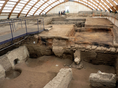
The Neolithic Site of Çatalhöyük consists of two tells with well-preserved remains from the Neolithic and Chalcolithic periods.
This was a large agrarian settlement that was permanently inhabited. Mud-brick houses have been found with wall paintings and other decorations. There were no streets, entrance to the buildings was via the roof and burials were mostly beneath house floors.
Community Perspective: The (still rural) site has a small museum, two excavation sites (one closed to visitors since at least 2022) and a reconstruction of a dwelling. The more interesting findings from Çatalhöyük (including wall paintings) are now on show in the “Museum of Anatolian Civilisations” in Ankara.
Chengjiang Fossil Site
Chengjiang Fossil Site holds marine fossils from the early Cambrian period, 530 million years ago, when life on Earth rapidly diversified.
A rich number of species has been found within the remains of a complex marine ecosystem. Most of the fossils are that of soft-bodied organisms.
Community Perspective: It’s fairly easily accessible from Kunming, though you have to get a taxi for the last 20km to “Maotianshan”. The surroundings are appreciated more by our reviewers than the site itself, which boasts a basic museum, with a showcase area of the cliffside where the first fossils were discovered but overall without much interpretation.
Decorated Farmhouses of Hälsingland
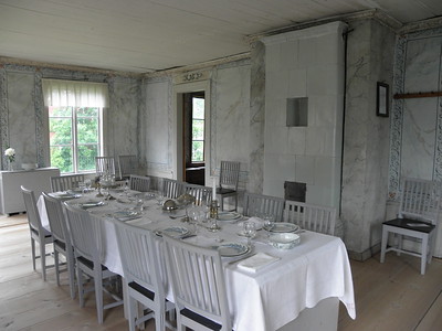
The Decorated Farmhouses of Hälsingland are seven large timber farmhouses with richly decorated interiors.
They date mainly from the 18th and 19th centuries. The decorations were made in the regional folk art tradition, and reflect the prosperity of the farmers of that period. A special room or even a separate house was set aside for festivities.
Community Perspective: The Erik-Anders farm is the most accessible (all are in private use), as it opens daily to tourists in summer. In Långhed you can stay in a similar-style guesthouse and gain access to the inscribed site in town, as described by Ian. Clyde visited the Pallars and Jon-Lars decorated farmhouses.
Elvas
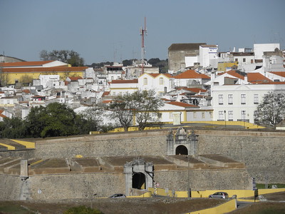
The Garrison Border Town of Elvas and its Fortifications comprise a frontier town that was strongly fortified from the 17th to 19th century.
Elvas guards a key border crossing between Lisbon and Madrid, demonstrating Portugal’s autonomy. The fortifications are of the bulwarked dry-ditched type: as such it is the largest surviving example in the world and it is considered a masterpiece of military architecture of its time. An aqueduct supplied the fortified town with water, so it would be self-reliant during a siege.
Community Perspective: a hidden gem showing remarkable authenticity and completeness. Tourists are almost absent - but this also means that not every building and every church is open to visitors.
Gonbad-e Qâbus
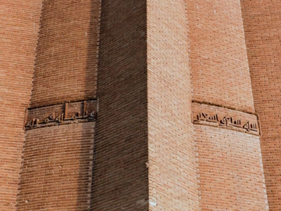
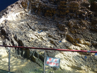
Gonbad-e Qābus is a monumental tomb tower that is an outstanding achievement of early Islamic brick architecture.
The 53 metres high tower was constructed to an intricate geometric plan so the brickwork could bear the load. Its form is cylindrical with a conical roof, which became the prototype for the construction of tomb towers in the wider region. It was built in 1006 as a tomb for emir Qābus ibn Voshmgir, but no traces of remains have been found inside the tower.
Community Perspective: This one is a long way off the route for visiting Iran’s other WHS. For a fee, you can enter the enclosure and climb its mound. After around half an hour and a few circumambulations, you will have seen it.
Grand Pré
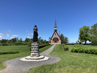
The Landscape of Grand Pré is a polder created for farmland by the Acadian community that holds high symbolic value for them.
The reclamation of the land in this tidal flooded zone was carried out in stages in the 17th and 18th centuries. The polderisation used dykes as well as a community-based management system still in use today. Grand Pré became the place of memory for the Acadian diaspora, as these descendants of the 17th-century French colonists were deported from here in 1755 by British colonial officers. A number of symbolic memorial buildings and monuments to commemorate this have been added to the landscape in the 20th century.
Community Perspective: the site has a large Visitor Center (closed November-April) that tells the Acadian history well. Frédéric describes several viewpoints from which to admire their polder landscape.
Grand-Bassam
The historic town of Grand-Bassam is an example of rational town planning from the colonial period.
Built in the 19th century, this seaport was the French colonial capital of Cote d'Ivoire. Europeans and Africans lived divided into separate residential quarters. It had commercial and administrative zones, in which historic buildings in a sober and functional colonial style have been preserved. The indigenous N’zima village and its vernacular architecture already existed before colonization and were later incorporated into the urban plan.
Community Perspective: Lauren visited in 2019, and found it easily accessible though without tourist infrastructure.
Heritage of Mercury

“Heritage of Mercury. Almadén and Idrija” comprises what were the two largest mercury mining centres in the world.
Spanish Almadén and Slovenian Idrijia produced the rare metal over a lengthy period. They became of strategic international importance due to the need for mercury in the process of extraction of silver and gold by the Spanish in America. The sites include the mine shafts, technical infrastructure and the mining towns.
Community Perspective: Idrija comes as a pleasant surprise to many and warrants a whole day. Solivagant is the only one so far to review Almadén.
Lakes of Ounianga
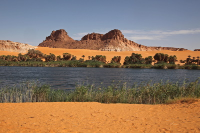
The Lakes of Ounianga are 18 connected, permanent lakes within the arid Sahara desert.
They are being fed by a system of fossil groundwater. The lakes are divided into two groups, 40km apart. They are the remaining part of a much larger lake that existed in this basin 5,000 - 15,000 years ago. The colour variety of the lakes, the floating reed carpets and the surrounding palm trees and sandstone landforms result in a place of high aesthetic beauty.
Community Perspective: The lakes are remote, they lie another day's drive north of the Ennedi Massif, across the pure desert of the Mourdi Depression and not far from the border with Libya. They are situated within an intriguing cultural landscape dedicated to the salt trade and the produce from date palms.
Lena Pillars
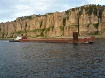
Lena Pillars Nature Park is renowned for its rock pillar landscape and exposure of Cambrian rocks.
The park occupies the right bank of the middle part of Lena River, which is lined by rock pillars up to 100m in height. They include fossilized reefs that carry among the most significant records of events related to the 'Cambrian explosion'.
Community Perspective: The site can be accessed from the Siberian town of Yakutsk, where tours are available for a combined jeep-boat visit. Martina and Alexander did it as a long day tour, while Lena kayaked the river for 10 days.
Lenggong Valley
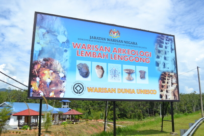
The Archaeological Heritage of the Lenggong Valley comprises four cave and open-air sites related to the stages of early human occupation of this area.
Paleolithic workshops and stone tools have been preserved when they were abandoned due to meteorite impact and volcanic ash. One human skeleton from that period has been found – an Australomelanesoid known as Perak Man, South-East Asia’s oldest most complete human skeleton which is radiocarbon dated to 10,120 BP.
Community Perspective: “the most disappointing of the three early man sites I have visited”. The only place that provides any understanding of this site is the Archeological Museum in Bukit Bunuh, which seems to be in a permanent state of refurbishment. The area is quite hard to visit on public transport, tips are provided by Jarek. Tours with local guides can give you access to the archeological sites and provide more background, but good tours are hard to come by.
Margravial Opera House
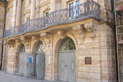
The Margravial Opera House Bayreuth is an 18th-century Court Opera House that is considered a masterwork of Baroque theatre architecture.
It is the sole surviving example of a Court Opera House in the world, and its layout, design and materials have been preserved mostly unchanged. As it is located in a public urban space instead of within the walls of a private residence, the Margravial Opera House can be seen as a precursor to the later great public opera houses.
Community Perspective: It’s the site that closed its doors almost right after becoming a WHS! Its interior has been inaccessible between 2012 and 2018, and you really needn’t go there for the exterior. Hubert was the first one to review it after the reopening and described the visitor experience.
Masjed-e Jâme'
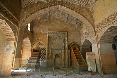
Masjed-e Jâme' of Isfahan is the prototype of a distinctive Islamic architectural style.
The mosque was the first to be built in the four-iwan architectural style (known from Sassanid palaces), placing four gates face to face. Its Nezam al-Molk Dome was the first double-shell ribbed dome. Developed from the 9th century onwards, it is the oldest Friday mosque in Iran and displays architectural styles of different periods.
Community Perspective: It’s an enormous complex with old brick halls (it’s not as flashy and shiny as some other famous mosques in Iran), but it also has beautiful fine mosaics and two great domes opposite each other. Try to be there before the tour groups arrive for a more intimate experience.
Mining Sites of Wallonia
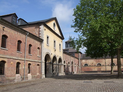
The Major Mining Sites of Wallonia represent industrial mining in continental Europe at various stages of the Industrial Revolution.
Developed in the 19th century, the Walloon mining basin became an exemplary centre of the Industrial Revolution outside England. The remains of the Grand-Hornu, Bois-du-Luc, Bois du Cazier and Blegny-Mine sites include surface and underground mining structures, industrial architecture and worker housing.
Community Perspective: The Grand Hornu is an aesthetically pleasing work of architecture, while at Blegny you can go on an underground tour. Bois du Cazier is an easy site to reach from Charleroi and has a number of exhibition spaces, including one dedicated to the Bois-du-Cazier disaster of 1956. Finally, Bois-du-Luc has a good mix of industrial and social elements.
Mount Carmel Caves
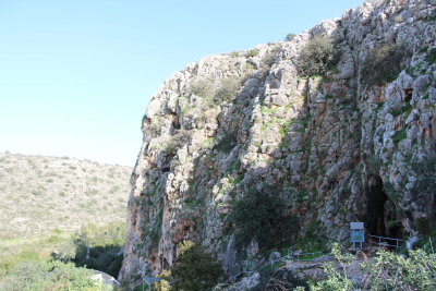
The Sites of Human Evolution at Mount Carmel: The Nahal Me’arot / Wadi el-Mughara Caves testify to more than 500,000 years of human evolution.
The four caves are situated on a cliff in the Mount Carmel range. The area was inhabited by both Neanderthals and modern humans. Findings such as skeletal material, pits and stone structures have made it possible to create a chronological framework of human evolution from the first appearance of modern humans to the transition from hunter-gathering to agriculture.
Community Perspective: As usual with paleontological sites, there is little to see for the casual visitor. The rock views of the surrounding natural reserve are the most gratifying visuals at the site. Solivagant has put the site into historical perspective.
Nord-Pas de Calais Mining Basin

The Nord-Pas de Calais Mining Basin is a mining and industrial cultural landscape along a 120km long coal seam in the far north of France.
It represents the large-scale coal mining of the 19th and 20th centuries, and its associated social developments such as the occurrence of major disasters, international migration and worker unionism. Preserved elements include pits, slag heaps, railway stations and mining villages with schools, religious and community buildings.
Community Perspective: Don’t expect anything as grandiose as the Ruhrgebiet in Germany. The Historic Mining Center in Lewarde (location #22, Fosse Delloye) is a good place to start. Nan and Claire have reported on some locations (there are 109 in total!) in Lens and Liberville.
Pearling
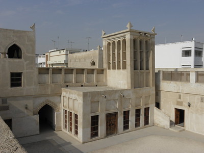
Pearling, testimony of an island economy, is a group of historic sites related to the harvest and trade of natural pearls.
The island city of Muharraq was the main pearl trading city in the Gulf and was prominent in the world until the introduction of cultured pearls by Japan in the 1930s. A pearl industry already existed here in Roman times. The inscribed area comprises Oyster beds in the territorial waters of Bahrain, two fortresses and the remaining buildings of the merchant quarter in Muharraq.
Community Perspective: although all components supposedly are connected via a Pearling Path, many are being renovated or are of little interest. The most rewarding components to visit are the Shaikh Isa Bin Ali House and the nearby Siyadi Complex in Old Muharraq.
Rabat
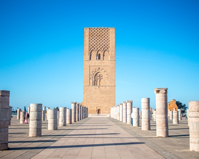
"Rabat, Modern Capital and Historic City: a Shared Heritage" shows different construction phases from the Almohad period (12th century) up to the present day.
The city was substantially modernized by the French from 1912 on when it became the capital of their Protectorate, resulting in the Ville Nouvelle. The modern town planning drew inspiration from the earlier Arabo-Muslim heritage. The site also includes older parts of the city such as the Oudaïa Kasbah, the Almohad ramparts and gates and the archaeological site of Chellah.
Community Perspective: The city overall has a living, cosmopolitan atmosphere. The Chellah, with the mixture of Roman and Islamic ruins, is worth seeing, as well as the Tour Hassan and adjacent Mausoleum.
Rio de Janeiro
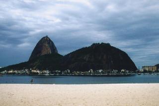
Rio de Janeiro, Carioca Landscapes between the Mountain and the Sea, covers an urban landscape shaped by its dramatic natural surroundings.
Rio’s natural landscape started to be altered in the 17th and 18th centuries to allow sugar and coffee growing. Its parks and gardens later became protected, and as such attributed to the outdoor living culture of the city. Guanabara Bay, Sugar Loaf and the statue of Christ the Redeemer have become global icons and an inspiration for artists.
Community Perspective: the magnificent views are its main drawcard. Be aware that the WHS boundary is actually pretty limited and excludes the majority of Rio’s built environment.
Rock Islands
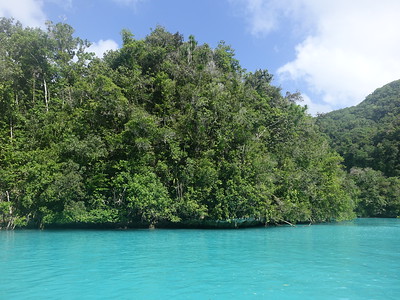
Rock Islands Southern Lagoon is a marine landscape that includes hundreds of iconically dome-shaped, uninhabited islands of great beauty.
The archipelago is of volcanic origin. Abundant rainfall has created diverse habitats, including 52 marine lakes which are “natural laboratories” for the scientific study of evolution and speciation. It is also a critical area for fish and coral preservation. Some of the islands were periodically settled by Palauans in the past, and they continue to visit. Prehistoric cave burial sites, rock art and remains of later settlements on the island clusters of Ulong and Ngemelis and three islands (Ngeruktabel, Ngeanges, and Chomedokl) testify of that.
Community Perspective: all reviewers enjoyed the not (yet) overcrowded surroundings, with days of kayaking, snorkeling, the occasional scenic flight and a visit to the famous Jellyfish Lake for the lucky ones. None have reported back on the cultural aspects of the site yet.
Sangha Trinational
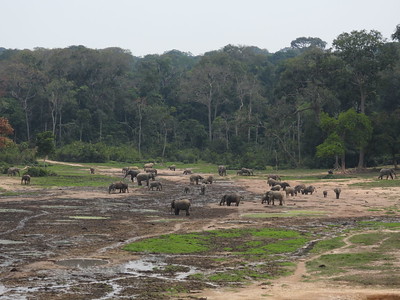
Sangha Trinational is a large and intact natural landscape, mainly consisting of humid forests plus wetlands and natural clearings.
These three contiguous national parks are centered along the Sangha River, a tributary to the Congo River. They harbour tree and mammal species that are much threatened elsewhere due to exploitation and poaching. Large mammals such as Forest Elephants, Gorillas, Chimpanzees, Sitatunga and Bongo are still present in healthy numbers.
Community Perspective: Els visited Dzanga-Ndoki National Park in the Central African Republic. The other two parks, Lobéké National Park in Cameroon and Nouabalé-Ndoki National Park in Congo, have stayed unreviewed so far.
Site of Xanadu
The Site of Xanadu encompasses the remains of Kublai Khan's legendary summer capital of the Yuan Dynasty.
The grassland capital at the edge of the Mongolian plateau includes the former city with temples and palaces, water control works, tombs, and traditional ovoo (stone cairn) shrines of the Mongolian nomads. Its plan shows a mix between Mongolian and Han Chinese traditions. It is also the place from where Tibetan Buddhism expanded over north-east Asia.
Community Perspective: It’s far from everywhere and you’ll need to take a taxi for the last 20km. However, the archeological site is fenced, requires an entrance fee and has multilingual signs. Michael found few remains from the Yuan Dynasty but imagined how the Mongols on horses entered the city after each victory in war.
Western Ghats
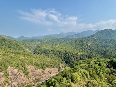
The Western Ghats is a forested mountain chain that shows high speciation in plant in animal life.
It has been formed during the break-up of the supercontinent of Gondwana some 150 million years ago, as the faulted edge of the Deccan Plateau. It forms a ridge from north to south across India, even influencing the monsoon weather patterns. Its rainforests, rivers and grasslands contain a high plant and animal diversity, including rare and endemic species such as Asian Elephant, Gaur and Tiger.
Community Perspective: out of the 39 inscribed components, Frederik visited the Kaas Plateau, while Nan and Shandos covered Silent Valley National Park.