Berat and Gjirokastra
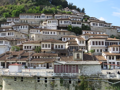
The Historic Centres of Berat and Gjirokastra are well-preserved Ottoman towns, decorated with outstanding examples of kule: Balkan-Ottoman style tower houses.
Berat has been particularly marked by the peaceful coexistence of Ottoman Islam with a large Christian minority. The designated area includes Berat Castle, mosques, churches, and the Gorica Bridge. Gjirokastra was built around a 13th-century citadel and developed into a regional center. Residential quarters, the bazaar, churches, and mosques were built vertically and in stone.
Community Perspective: the two towns lie some 150km apart, complement each other and they warrant an overnight stay each.
Biblical Tells

Biblical Tels - Megiddo, Hazor, Beer Sheba are historic settlement mounds with biblical connections.
The cities dated to the Bronze and Iron Age, and flowered from the 12th to 6th century BCE. They show early urban development in the Levant by a centralized authority that had control of trade routes. The tels hold remains of palaces, fortifications and water collection technologies.
Community Perspective: Megiddo is the most interesting of the three, displaying a sunken grain silo, a huge water cistern, and a water tunnel.
Cienfuegos
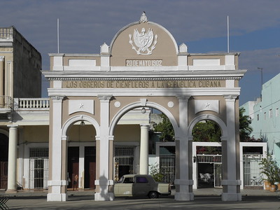
The Urban Historic Centre of Cienfuegos is the best extant example of 19th-century urban planning principles in Latin America.
The homogenous architecture and streetplan of this seaport was influenced by the Spanish Enlightenment and French colonists. New ideas of modernity, hygiene and order were implemented here, and the the streets are of a neo-classic straight and symmetric design, with the use of porches and arcades.
Community Perspective: “the most elegant and prosperous Cuban city”. Visit the Parque José Marti, the central square surrounded by monumental buildings, and the Teatro Tomas Terry.
Coiba National Park
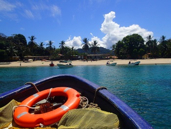
Coiba National Park and its Special Zone of Marine Protection comprise Coiba Island, 38 smaller islands and the surrounding marine areas that are important for the survival and study of many species of fish and marine mammals.
After Coiba got disconnected from the mainland (some 12,000 years ago), new fauna and flora species are being formed, turning the island into a scientific laboratory with a high level of endemism. Pelagic fish and marine mammals inhabit the reefs around the island.
Community Perspective: the park can only be reached with a day trip by boat that takes you surfing, snorkeling or diving. One reviewer calls it “nature at its finest and most untouched”, the other “a disappointing experience”.
Dong Phayayen
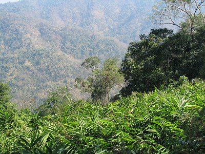
The Dong Phayayen - Khao Yai Forest Complex is renowned for its high number of fauna species.
The five protected areas cover a tropical forested area in the mountains of northeast Thailand. High annual rainfall results in a number of attractive waterfalls. Its endangered or rare fauna includes the Asian Elephant, Tiger, Leopard Cat, Pileated Gibbon, Asiatic Black Bear, Malayan Sun Bear, Smooth-coated Otter and the Siamese Crocodile.
Community Perspective: Khao Yai is the most visited park, both in general and by our reviewers. Frederik also managed to cover Thap Lan (bamboo forest), at a later stage he went to Pang Sida (butterflies), and Ta Phraya (hoodoos) as well. Dong Yai Wildlife Sanctuary still remains unreviewed.
Gulf of California
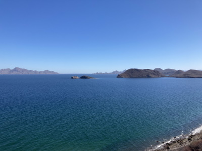
The Islands and Protected Areas of the Gulf of California comprise a stunning coastal and marine landscape.
The areas include 244 islands and 9 further protected terrestrial and marine areas, located between Baja California and the Mexican State of Sonora. It is home to a third of the world's marine mammal species, including the endemic and critically endangered Vaquita. There are also impressive numbers of resident and migratory birds on the islands such as Blue-footed Booby and Black Storm Petrel.
Community Perspective: As this is a vast area spanning both sides of the Gulf, you need to make a choice of which component to visit and reserve some kind of boat tour. Clyde has covered Islas Marietas (hub: Puerto Vallarta), Els Bahia de Loreto (hub: Loreto), and Kyle Cabo Pulmo, Islands of the Gulf of California, Cabo San Lucas and Balandra (hub: Cabo San Lucas or La Paz).
Humberstone and Santa Laura Saltpeter Works
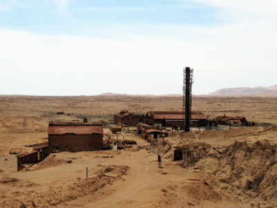
The Humberstone and Santa Laura Saltpeter Works represent the technical heritage and the social transformation brought about by the saltpeter industry.
Exploiting the largest deposit of saltpeter in the world, these two industrial sites were in use from 1872 until the mid-20th century to produce nitrate fertilisers for the rest of the Americas and Europe. Thousands of workers lived in company towns in this remote environment and developed a distinctive Pampinos culture.
Community Perspective: Humberstone has the best-preserved town remains, while Santa Laura is the more impressive for its industrial area but is in a bad and potentially dangerous condition. The sites lie only 2 km apart and can easily be visited by local bus from Iquique.
Incense Route of the Negev
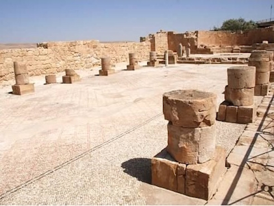
Incense Route - Desert Cities in the Negev reflects the hugely profitable trade in frankincense and myrrh which flourished 2300-1800 years ago.
The site comprises the four Nabatean towns of Haluza, Mamshit, Avdat and Shivta, with their associated fortresses and agricultural landscapes, which are located along a 100km stretch of the Route. The Nabateans used a sophisticated water collection and irrigation system to allow large-scale agriculture in this harsh desert.
Community Perspective: The site lies in a less-travelled part of Israel. Avdat is the most touristy of these four archeological sites. Although the ruins (walls and rubble!) are originally Nabatean, a lot of what you see now is of a later (Christian) period.
Kunya-Urgench
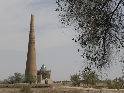
Kunya-Urgench covers the remains of a major trade center on the Silk Road and the capital of the Achaemenid Khorezm region.
The archeological site contains many ruins of monuments from the 11th-16th centuries, including fortresses and a 60m high minaret. Its distinct decorative style and architecture such as dome constructions has influenced buildings in Iran, Afghanistan and the Moghul Empire. The place also is still a place of pilgrimage.
Community Perspective: this site is on a more manageable scale than Merv, there's a footpath that links the monuments and “the atmosphere of semi-desolation in the desert does have a certain appeal”. Solivagant particularly enjoyed the area where local people came to pray for fertility. Clyde found the Mausoleum of Turabek Khanym and its tiling the absolute highlight.
Le Havre
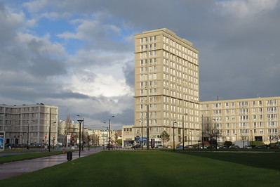
Le Havre, the city rebuilt by Auguste Perret, is an outstanding post-war example of urban planning and architecture.
As a result of numerous air raids during World War Two, the port of Le Havre lost most of its city center buildings. Reconstruction planning began in 1945 with Auguste Perret as chief architect and city planner. Historical patterns like streets and squares were preserved, as well as the 16th-century cathedral that survived the bombings. Modernist buildings based on reinforced concrete were added and prefabrication was used, in order to create a homogenous ensemble.
Community Perspective: Dull and uninteresting to some, but the wide boulevards, the spacious squares, the straight lines and the plain forms do hold an appeal to others. You can visit the interior of the tower of Saint Joseph and a reconstructed show flat designed by Perrett’s studio. Ian has explained that it is even fun for kids.
Macao
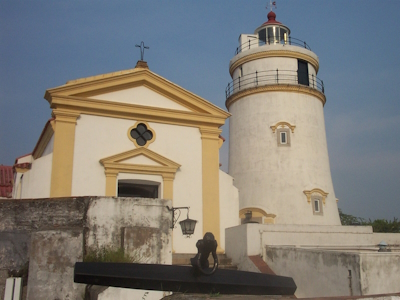
The Historic Centre of Macao represents the early and long encounter between Chinese and European civilizations.
Macao was the first European enclave in Asia, starting with the arrival of Portuguese tradesmen in 1557. Over the years they developed Macao into one of the major trade ports in Asia - as a stopover on the route to Japan or as part of the Silk Route by sea. Both Western and Chinese roots are reflected in its architecture.
Community Perspective: It’s a well-preserved melting pot of architectural styles and full of vivid colours. Highlights include the Portuguese buildings at Guia Hill and the very old A-Ma Temple.
Mostar
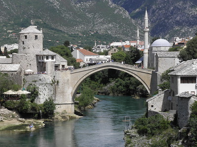
The Old Bridge Area of the Old City of Mostar symbolizes the coexistence of culturally, ethnically and religiously diverse communities.
This Ottoman frontier town developed from the 16th century onward, with the Old Bridge as its major landmark. During the Austro-Hungarian period of the 19th century, a number of administrative and Christian religious buildings were added. These were mainly located on the right bank of the river, across from the old Ottoman (Muslim) town. The Bridge and much of the old town were destroyed during the war in the 1990s and rebuilt in 2004.
Community Perspective: Most reviewers are impressed by the quality of the restorations, although their ‘newness’ shows. Mostar is a touristy town again, and visiting early in the day is recommended. Solivagant visited in 1988 and shares a photo of the Bridge before reconstruction. Els cynically ponders about the site’s ‘peaceful coexistence’ OUV.
Nesvizh
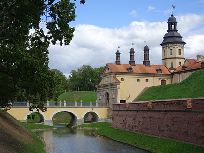
The Architectural, Residential and Cultural Complex of the Radziwill Family at Nesvizh consists of a residential castle and the Corpus Christi Church, which had their influence on architecture all over Central and Eastern Europe.
The Radziwill dynasty acted as politicians and patrons of art from the 16th to 19th centuries. They incorporated influences from Southern and Western Europe, leading to the Renaissance and Baroque design of this complex. An Italian architect was responsible for creating the domed church.
Community Perspective: the interior of the Corpus Christi church has good frescoes and an interesting family crypt, while the palace comes with the usual series of European-style palace rooms.
Osun-Osogbo
The Osun-Osogbo Sacred Grove is a primary forest that sustains living Yoruba cultural traditions.
This grove in Osogbo is the largest remaining shrine to Osun, the goddess of fertility, and other Yoruba deities. Many of these places of worship were revived in the second half of the 20th century when the ‘Movement of New Sacred Artists’ added sculptures and other works of art. The site is in active religious use and there's also an annual festival. The plants in the forest are used for traditional medicine.
Community Perspective: surprisingly, many of the reviewers visited long ago (as far back as 1968) and most highlight the role that Austrian Suzanne Wenger played in the conservation of the site. Solivagant visited as early as 1975 and provides a good overall overview of the site’s history and the ‘situation on the ground’.
Plantin-Moretus Museum
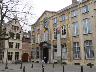
The Plantin-Moretus Museum is linked with the spreading of ideas of European humanism via its printing business Officina Plantiniana.
The museum is housed in the former residence and printing business of famous printers Christoffel Plantijn and Jan Moretus. They had a successful printing workshop and publishing house in the late 16th century, printing humanist and scientific publications. The workshop, its furnishings and the immaterial heritage associated with the business have been preserved in the original location.
Community Perspective: Everyone seems to like this one, and you can easily spend two hours inside drooling over the typographical matrices, the globes, the Gutenberg Bible and the Rubens paintings.
Qal'at al-Bahrain
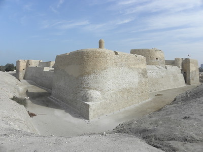
Qal’at al-Bahrain – Ancient Harbour and Capital of Dilmun is the archaeological site of a port that was once the capital of the Dilmun civilization and served more recently as a Portuguese fort.
It is a typical tell - an artificial mound created by many successive layers of human occupation. The hill shows almost continuous remains of fortifications and palaces from ca. 2300 BCE to the 16th century BCE. They span the Dilmun, Tylos, later Islamic societies, and the Portuguese period. This makes it a rare archeological and historical reference site in Eastern Arabia and the Gulf region.
Community Perspective: it is the most famous tourist attraction of Bahrain and popular among locals and tourists, and can easily be visited by rental car or on public transport. Reviewers found the Portuguese fort (too) heavily reconstructed and the excavated remains of the Bronze Age Dilmun civilisation are not very extensive.
Shiretoko
Shiretoko holds rich, correlated terrestrial and marine ecosystems that are influenced by seasonal ice in its sea waters.
The peninsula’s forests are home to a variety of wildlife, including brown bears, deer and foxes. Its biodiversity is very important for salmon, migratory birds and sea mammals, including sea lions. Life in the sea, rivers and forests interacts via salmonid species swimming upstream to spawn and becoming food resources for terrestrial animals.
Community Perspective: Utoro is the tourist hub for this park, from here you can take a cruise along the coast or a bus ride to the Five Lakes. Be aware that the season lasts only until late September (and essentially starts only in July), and that it can get very cold afterward.
Soltaniyeh
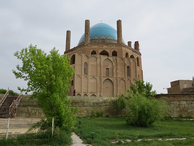
Soltaniyeh was the capital of the Ilkhanate, an empire of Mongolian origin that ruled over Persia in the 13th and 14th centuries.
The city’s main remaining feature is the ‘Dome of Soltaniyeh’, which houses the mausoleum of the Ilkhanid Khan Oljaytu. This is considered a key monument in the history of Islamic architecture: it is the oldest double-shell dome in the world. The octagonal building is crowned with a 50m-tall dome covered in turquoise blue glazed bricks and surrounded by eight slender minarets.
Community Perspective: All reviewers so far have found the interior covered in scaffolding, but you can still climb the stairs and walk on the second and third-floor galleries and admire the dome’s tile and brick work.
Struve Geodetic Arc
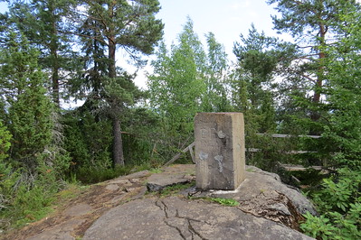
The Struve Geodetic Arc is a technological ensemble that played an important role in the development of earth sciences.
This chain of survey triangulations, stretching from Hammerfest in Norway to the Black Sea, was established to measure the exact size and shape of the earth. It was developed and used by the German-born Russian scientist Friedrich Georg Wilhelm von Struve in the years 1816 to 1855.
Community Perspective: with its 34 remaining stations, spanning 10 countries and over 2,800 km, this has become a real Community Cult Classic, representing the “reductio ad absurdum” of the scheme. To the uninitiated: you may expect to see a slab of concrete with a small concrete fence around it; Ian describes the cult appeal well in his review. Many are located in remote rural areas, often on hilltops. The best among them is the Tartu old observatory, which has an exhibition inside. The ones in Belarus are covered by Jarek and Zoe, the one in Moldavia by History Fangirl, Michael ‘did’ Ukraine, and Els Latvia, while Svein and Solivagant described Norway. Others in the Baltic States, Sweden and Finland have been regularly reviewed as well.
Syracuse
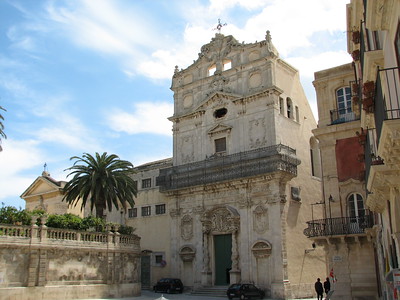
Syracuse and the rocky Necropolis of Pantalica bear testimony to the development of Mediterranean civilization in the past 3000 years.
Syracuse was one of the greatest Greek colonies. The remains from that period can be found on the island of Ortygia and at the archeological park of Neapolis. Later civilizations, such as the Byzantines, Arabs, Normans, Bourbons and Aragonese also left their mark on Ortygia. The Necropolis of Pantalica lies 40km away and holds rock-cut tombs made by indigenous people of Sicily.
Community Perspective: Ortygia is a pleasure to explore on foot and its Duomo is recommended for a visit as it has developed constantly like the city, from the Ancient Greek to the Baroque. The Necropolis at Pantalica is “nothing special”, and Alikander made it to the third component of this eclectic site, the archeological park of Neapolis.
Vredefort Dome
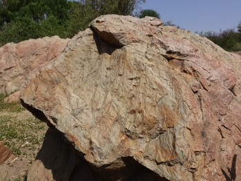
The Vredefort Dome covers the most representative part of the largest meteorite impact site in the world.
The crater has a diameter of roughly 300 km, created by an asteroid of 10-15 km in diameter. It was formed over two billion years ago, making it also one of the oldest verified impact craters. The site still shows on the surface geological structures that are the result of the impact. Nothing of the meteorite itself has been found.
Community Perspective: the included area is accessible on your own from Parys, but is best explored with a guide as the geological evidence isn’t exactly self-explaining and some locations are fenced off. In the reviews below you can find the details for recommended guides.
Wadi Al-Hitan
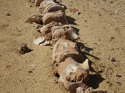
Wadi Al-Hitan (Whale Valley) is the largest and most important site in the world for whale fossils.
These fossils belong to a now-extinct subspecies of whales, which show their transition from land animals to marine mammals: they still have hind legs. The fossils have been found on the surface of the now completely dry landscape of the Western Desert, which was part of the enormous Tethys Ocean 40 million years ago. They comprise many complete skeletons and have been well-preserved in high numbers.
Community Perspective: it can be hard to reach as it is off-the-beaten-track and there may be police checkpoints along the way, but all reviewers managed to without issue (see Nan’s review for public transport options). Once on site, the fossils can be visited by following a signposted trail from the orderly visitor center.
West Norwegian Fjords
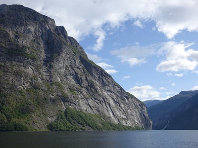
The West Norwegian Fjords – Geirangerfjord and Nærøyfjord are archetypical for fjord landscapes around the world.
They are also among the world's longest and deepest fjords, long inlets of the sea with steep sides or cliffs, created by a glacier. Geirangerfjord and Nærøyfjord offer outstanding scenery, with crystalline rock walls that rise up to 1,400 metres from the sea, forests, glaciers and high waterfalls. These fjords still display active geological processes.
Community Perspective: “among the very best scenic sights in Europe”, it can be seen by joining a (touristy) boat tour, hiking or driving to the scenic viewpoints. John describes a trip to both on public transport, while the Naeroyfjord features prominently on the 'Norway in a Nutshell'-tour that can be done from Bergen.
Yaroslavl
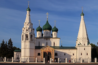
The Historical Centre of the City of Yaroslavl is dotted with 17th-century churches and an example of Catherine the Great's neoclassical town planning reform.
In the 17th century, Yaroslavl was Russia's second-largest city and its main churches date back to that period. They belong to the so-called Yaroslavl type: built of red brick, with bright tiled exteriors. In the late 18th century, the cityscape was redeveloped in a harmonious and uniform Neoclassical style.
Community Perspective: Yes, another day trip from Moscow, though a long one so you may better stay overnight (see Nan’s review for the advantages). The city is worth about half a day and its leafy streets are easily walkable. The views from the Volga walkway are great. Solivagant refers to the visual impact the Soviet period had on Yaroslavl.
Extended Sites in 2005
Belfries
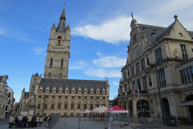
The Belfries of Belgium and France symbolize the growing independence of cities from the feudal system in the Middle Ages.
The site comprises 56 bell towers that were built between the 11th and 20th centuries. The towers are mostly found in town centers, and connected to the local town hall or church. They were used as watch towers but also as meeting places for the city councils.
Community Perspective: “They’re all different” – so you have to visit a couple of them to get the idea. Fortunately, they are often located in towns that are also part of the Flemish Beguinages WHS, or are WHS in their own right – Nan has provided a list of possible combinations.
William Sambrook England - 01-May-05
The beautiful belfry in Mons (Hainaut) is the only Baroque one in Belgium and symbolic of the city. It is located in the highest part of the town, built as the name Mons suggests, on a hill. The youth hostel is right next door. Mons is in the industrial Borinage region of Southwest Belgium and often overlooked in favour of the showcase cities of Flanders. There are, however more world heritage sites or parts of world heritage sites in Hainaut province (4) than in any other in Belgium.
Read OnFossil Hominid Sites
The Fossil Hominid Sites of South Africa comprise three groups of limestone caves where early hominid fossils have been found that contribute to the understanding of the evolution of humankind.
The findings include two different hominid species: Australopithecus africanus and Australopithecus robustus. Among the inscribed locations is the Taung Skull site, where in 1924 the first example of the Australopithecus africanus was discovered. The oldest fossils date to 3.5 million years ago. The oldest stone tools have been discovered here too, and the oldest evidence of controlled use of fire.
Community Perspective: As always, early hominid sites ask a lot from your imagination. Sterkfontein is the most accessible of the 3 locations, but a more intimate experience can be had at Makapang.
André Dique United Kingdom - 01-May-05
It is possible to visit the Sterkfontein caves but you have to find your own way to get there. They do tours of the caves for a nominal fee (tips are optional) but don't expect to see many fossils. The archeolocial digs were all closed off.
The caves are impressive and it is a good day out, considering the many unique private restaurants in the area. That way you could drive around the Highveld countryside enjoying some time away from the city bustle of Johannesburg.
Read OnFrontiers of the Roman Empire

The Frontiers of the Roman Empire comprise significant remains of the Limes Romanus, a border defense or delimiting system of Ancient Rome.
It includes the Upper German-Raetian Limes, Hadrian’s Wall, and Antonine Wall, all built in the 2nd century CE in the northwestern part of the Empire. The Romans constructed military installations (forts, barriers, watchtowers, ditches) and related civilian settlements, linked by roads, to separate their citizens from the “barbarians”.
Community Perspective: The Roman Fort of Saalburg is the most visited part of the German component. The remains of Hadrian’s Wall can be admired on a hike (Ian), by the AD 122 bus, or by some selective exploration (James). A part of the (less well-preserved) Antonine Wall has been covered by Jay and Allan.
David Berlanda Italy / Czech Republic - 01-May-05

In our trip to Germany we have visited the Roman fort of Saalburg, part of the 220 kilometres Limes barrier Raeatian section, one of the walls that have been marking the boundaries of the Roman empire for some centuries. The original fort (90 AD) covered an area of about 0,70 hectares and had a rectangular plan with corner towers. In 135 AD was built a larger fort, of 3,2 hectares (221 by 147 metres), over the earlier one, with four gates, a stone and timber defence wall with rampart walk and a double ditch. The remains of many internal buildings have been excavated and entirely reconstructed in stone and timber under the emperor William II
Read OnMountain Railways of India

The Mountain Railways of India are three fully operational railway tracks that are fine examples of 19th-century technology and the changes they brought with them.
These railways built during the British colonial period stimulated population movements between the plains and the mountains. Heavy and complex engineering, including multi-arch viaducts, tunnels, retaining walls, and a very large number of curves, was used in order to overcome the mountain conditions.
Community Perspective: “a great experience”, both for the landscapes and the use of the original railway equipment and infrastructure. The site includes the Darjeeling Himalayan Railway (covered by Solivagant), the Nilgiri Mountain Railway (Els), and the Kalka-Shimla Railway (Jarek).
Solivagant UK - 01-May-05

India possesses a number of “Hill Railways” built by the British to aid government officials and others in their escape from the major cities to the nearest Hill Country. It is possible that the Niligri Hill rack railway from Metupayalam to Ooty might soon be added to the WHS list but the Darjeeling Himalayan Railway (DHR) from New Jaipalguri/Siliguri to Darjeeling is already inscribed. The World’s industrial heritage is certainly not over-represented on the WHS list and I only know of 3 railway related sites (The DHR plus Semmering in Austria and the Mumbai Railway Station).
Read OnNanda Devi and Valley of Flowers
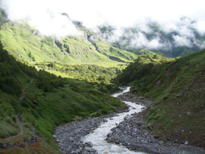
Nanda Devi and Valley of Flowers National Parks cover mountain landscapes in the West Himalayas that are renowned for their diverse alpine flora.
The Nanda Devi is India's second-highest mountain, and its park holds a spectacular landscape of glaciers, moraines, and alpine meadows. The nearby Valley of Flowers has diverse flora and is known for its medicinal plants and a huge variety of butterflies. Mammals encountered in both parks include tahr, snow leopard, musk deer, serow, Himalayan and black bear.
Community Perspective: We're still awaiting a first full review. Nanda Devi NP is closed to tourism (and mountaineering), while the Valley of Flowers does see a decent number of visitors. Go and watch the flowers in full bloom in July-August.
Hiranmay Ghosh India - 21-Aug-11
I visited the Valley of Flowers last week. While there were quite a bit of hardship on the route because of landslides, the valley provided an exhilarating experience. The flowers were in full-bloom and moist with rains. I could not see much of the mighty peaks due to clouds though!
Read OnWorks of Antoni Gaudí

The Works of Antoni Gaudí represent the creative architectural works of this Modernist architect.
The Works consist of seven of his buildings from the late 19th and early 20th centuries in and around Barcelona. They comprise both private residences and public works, including their gardens, sculptures and other works of art. His eclectic style was unique and individual, and made use of modern construction techniques.
Community Perspective: Hard to miss when you’re in Barcelona as especially the Sagrada Familia and Parque Güell are major tourist attractions. Try to get into one of the residences such as Casa Mila (described by Ian, Hubert, Ilya), Casa Vicens (by Tonisan) or Casa Batlló (by Els, Hubert, Ilya) for a more up-and-close experience.
- 01-May-05
I too have admired Gaudi's querky designs. But spare a thought for the poor builders. Gaudi's designs are a nightmare to construct. It is the reason why the Sagrada Familia church has been under construction for 125 years already, and still has some way to go.
Read On