Great Burkhan Khaldun Mountain
The Great Burkhan Khaldun Mountain and its surrounding sacred landscape represent the formalised mountain worship by Chinggis Khan which helped to unify the Mongolian Empire.
The permanently snow-capped Burkhan Khaldun is one of four sacred mountains of that period when official status was given to the long-standing shamanic traditions of mountain worship by the nomadic peoples. It also is the reputed burial site of Chinggis Khan. The landscape further holds a pilgrimage path and three major stone ovoo-s. The mountain and its history is described in the epic 'The Secret History of the Mongols'.
Community Perspective: Michael is the first and only reviewer so far: he was able to reach the site in wintery circumstances and enjoyed the remote, wide-open, mountain scenery. He has described his visit in detail, with both practical information (there is an entrance fee!) and an interpretation of the site’s meaning.


Map of Great Burkhan Khaldun Mountain
Community Reviews
Michael Ayers

Visit in March 2022.
When I began my second period of long-term travel in 2019, there were a small number of countries that I wanted to visit more than any others. One of those was Mongolia, a place that has fascinated me for decades. Accordingly, I planned a lengthy visit, to begin in July 2020, that would fit my usual travel goals, namely, to see a large portion of the country traveling by bicycle, to experience as much of its natural endowment as possible, and, of course, to visit at least two of its World Heritage Sites. I don’t need to explain why the 2020 visit never happened, and, with Mongolia closing more tightly than most other countries, it seemed certain to me that I never would be able to see that part of the World. However, after I had finally decided that I could end my wandering, I found myself still needing to cross the entire Eurasian land mass, from east to west, in a fairly expeditious manner. Just as I was about to start that process, I happily noticed that Mongolia had recently fully reopened its borders, and so I could not pass up the opportunity to finally make a stop there.
The major caveat was that, while my original plans would have involved seeing the steppes in the green flush of summer, with the concomitant increase in observable wildlife, in this case I would only be in the country for the last two weeks of March. Any descriptions of the harsh and lengthy nature of winters on the Central Asian High Plateau are certainly not exaggerations. Indeed, only on the final two days of my time there did the temperature rise above 0C, with the overnight low in one instance dropping to a frigid -25C. That meant that the visible landscapes would alternate between lightly snow-covered and stark, lifeless brown, and the amount of wildlife likely to be seen would be minimal. Additionally, while I may have occasionally been a little over-adventurous on some of my trips in the past, I would also like to think that I am not an idiot, and so had to accept that any meaningful amount of cycling under those conditions would not be a good idea.
Therefore, I did something that I normally wouldn’t, and arranged for package tours from local companies to visit two of the WHSs. For Great Burkhan Khaldun Mountain, after a few email exchanges with various companies, I connected with a freelance guide who was able to arrange for food, accommodations, an off-road vehicle, and driver. For both of these tours I was the first international client in over two years, so there was no problem with availability. Because of the usual “single supplement,” and also because of recent inflation for various items, like fuel, the costs for these trips were a little higher than I might have expected, but I really couldn’t do much about that. For Burkhan Khaldun, the tour involved one day at the Site, two days at other cultural areas further to the east, and one long day to return to Ulaanbaatar.
There is really only one way to reach the Burkhan Khaldun Site. Travel by road on the main highway east from Ulaanbaatar for 120 km to the town of Baganuur. That town was built in the 1970s to support a huge coal mine just to the south, is surpringly large, and contains most necessary services. From there the route turns north along typical Mongolian dirt roads, through the flat valley of the Kherling River, a featureless area that was formally a Russian Army base until the late 1980s. There is a new road being constructed as far as the village of Mungunmorit, fifty kilometers north of the highway, but there is no way to know exactly when that will be completed. I was told that at that time there were a few very basic homestay places in Mungunmorit, though it is reasonable to assume that once the new road is complete a more tourist-oriented accommodation may be built there, which would make that village a good base from which to visit the Site. After around another thirty kilometers of dirt road, you unceremoniously enter the core zone of the Site, and a few kilometers beyond that the road curves to the east and crosses a wooden bridge, which appears on the UNESCO map of the Site, and then reaches the main gate to the protected area. At the time there was an entry fee of around $US 3.00 per vehicle, per day. From the end of the congested part of Ulaanbaatar to that point requires about four and a half hours of travel.
There are a few dozen families living just inside the core zone, in typically rural Mongolian conditions, one of which is located a couple hundred meters before the wooden bridge and has a Ger available for tourists to stay in. There is another Ger just past the gate, which may also be available, so it is possible to stay within the core zone. We spent the first night at the family’s Ger, the owner of which has lived at that location for his entire life. Interestingly, he also served as a guide for the pre-inscription evaluation visit made by Mongolian and UNESCO officials, and showed me his “Commemorative Inscription Certificate,” signed by the UNESCO Director-General, which he received as appreciation for his efforts.
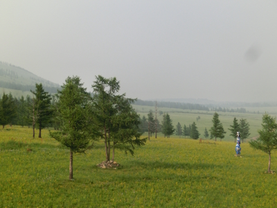
It is possible to continue about another thirty-five kilometers into the Site on the dirt road. One of the concerns the Committees had during the Site’s evaluation was that increased tourism would degrade the important characteristics of the Pilgrimage Route into the Site, and I was worried that, by going in using a motorized vehicle, I might be contributing to that. However, the dirt road had been in place for thirty years at the time and it seems unlikely that the numbers of tourists will increase drastically any time soon. Along the way the route passes near a handful of places marked as "Cultural Sites" on the UNESCO map. Three of those, Lower-, Middle-, and Upper-Khoriud, are located where three perpendicular valleys meet the Kherling Valley. These were originally guard posts established in the thirteenth century, each a place where one or two families lived, who prevented anyone from traveling further towards Burkhan Khaldun. This responsibility was handed down, from father to son, for seven hundred years, until the Communist takeover of Mongolia in 1921, but today there is nothing visible at those locations. The “Two Trees Entrance” is also non-obvious, though that may be a fairly modern-looking gate/monument that is passed along the way. Finally, after ascending a short, but steep, hill you reach the only location where there is something tangible, of a cultural nature, available to see, namely, the “Threshold Pass of Heaven” (pictured.) Located there are two Ovoos, the Mongolian version of cairns, one large and modern, with an already-fading WHS plaque, and another of more modest, traditional design. With clear conditions, it is also possible to see a portion of Burkhan Khaldun itself, but, in all honesty, at that distance the mountain looks extremely ordinary. To get closer to the base of the mountain normally requires leaving all vehicles at the pass for the final ten kilometers. We had no plans to continue further, and, indeed, we were advised against attempting to do so, due to the wintery conditions. Once a year a spiritual ceremony is held at the base of the mountain, but I am not sure how large that is, or how it is arranged. At the summit of Burkhan Khaldun, there are two more Ovoos, built in a low-to-the-ground design, so as not to be visible from the base of the mountain, however, the summit is off-limits to anyone apart from local shamans. I was told that it is possible to sneak up there on your own, but that doing so would risk having some severe misfortunes befall anyone who did so later on.
A few years earlier, I spent a considerable amount of time studying maps and satellite imagery to determine if I could reach the Core Zone on my own by bicycling. At the time I concluded that I probably could, but I was not entirely sure. After seeing the Site I think that I could have reached the start of the core zone without much trouble, and, given the ability to camp near the entrance, and the availability of basic provisions not very far away, I think I would have been able to reach the pass as well, and that would definitely be one of the best ways to visit this Site. However, that would be dependent on how wet the road was at the time. In March, our vehicle had little trouble because the road was frozen rock-solid. During the spring thaw, and the summer rainy period, it would be expected to be somewhat less than ideal. I was told that the best times to visit the Site are mid-May to mid-June and mid-August to mid-September, periods when it should be reasonably dry, somewhat warm, and without the mosquitos of mid-summer. At those times it is also possible to arrange trips to the interior of the Site using horses, which would be another fine way to see the Site. Another advantage of visiting at those times would be increased possibilities for wildlife sightings. In March, there were a few resident birds around, but our only really interesting observation was a brief glimpse of a Gray Wolf, its fur stained blood red after feeding on a recently-killed Elk carcass we found lying on the road.
In the original nomination file, there were to be two other locations included in this Site, the Sacred Binder Mountain and Baldan Bereeven Monastery. These were seen unfavorably by the advisory committees, with the reasoning that they were not currently in legally protected areas and were not specifically related to Chinggis Kahn and the founding of Mongolia, a topic that was considered to be more suitable for the Site, relative to the more general “Sacred Mountains” theme of the original proposal. Consequently, both were removed from the final nomination. We didn’t visit the Monastery, but I disagree with that change and think that Binder Mountain should have been included in this Inscription. That is primarily because Binder does provide a location which contains something with visible cultural and historical relevance and which can be visited fairly easily. Specifically, there is an area with numerous boulder outcrops where a wide variety of rock art types are present. These include petroglyphs of subjects like animals, typical of very old cultures, iconic symbols, some of which were adopted as the personal symbols of Chinggis and other Mongol Khans, and a great number of text inscriptions, presumably Buddhist chants, written in archaic forms of Mongolian, Tibetan, and Chinese scripts, and probably some other languages as well. Along the route between Burkhan Khaldun and Binder, but outside of the current Buffer Zone, were two small, unmarked, sites with Burial Mounds and Deerstones, which were also quite interesting.
I definitely enjoyed my visit, but I am unsure about how to recommend this Site. I think that it really depends on one’s expectations going in. If you wish to get a very in-depth understanding of the cultural and historical significance of the place, you will likely leave somewhat disappointed. However, if you are also willing to enjoy the remote, wide-open, mountain scenery, then a visit will be more rewarding. Consequently, in addition to including Binder, I think that this Site should have been inscribed as a Mixed property. The entire Site is located at the intersection of boreal forest and steppe biomes, and, while that is not the type of glamorous habitats that usually get inscribed as natural Sites, it is very important, ecologically, and that should be recognized as worthy of protection.
Read more from Michael Ayers here.
Community Rating
Site Info
- Full Name
- Great Burkhan Khaldun Mountain and its surrounding sacred landscape
- Unesco ID
- 1440
- Country
- Mongolia
- Inscribed
- 2015
- Type
- Cultural
- Criteria
-
4 6
- Categories
- Religious structure - Indigenous
- Link
- By ID
Site History
2015 Advisory Body overruled
ICOMOS advised referral
2015 Revision
In final stage of nomination, locations were limited from 3 to 1 by State Party. Sacred Binder Mountain and Baldan Bereeven Monastery were omitted.
2015 Inscribed
Site Links
Unesco Website
Related
Connections
The site has 17 connections
Ecology
History
Individual People
Religion and Belief
Science and Technology
Timeline
Trivia
Visiting conditions
WHS Names
WHS on Other Lists
World Heritage Process
Visitors
14 Community Members have visited.
The Plaque
No plaque has been identified yet for this site.