El Pinacate
El Pinacate and Gran Desierto de Altar National Biosphere Reserve represent a large and pristine desert landscape with a rich biodiversity.
The site, located in the Sonoran Desert, comprises the Pinacate shield, a dormant volcanic area, and the Gran Altar Desert with its active sand dunes that can reach 200m in height. The dark-coloured volcanic area forms a stark visual contrast to the sea of dunes. Among the many endemic plants and mammals is the Sonoran Pronghorn.
Community Perspective: Start your visit at the excellent Schuk Toak visitor center, from where you can walk into the dunes or drive your car on the unpaved roads (better with high clearance) into the volcanic part of the park, as described by Kyle. Els and Clyde visited as part of an overnight camping tour.

Map of El Pinacate
Community Reviews
Clyde

I visited this WHS in spring 2024. At first glance El Pinacate and Gran Desierto de Altar National Biosphere Reserve seems to be made up of two completely different components. By visiting the great Schuk Toak Visitor Centre (usually closed Monday to Wednesday, but not always) and its interesting lava trails + 5 kilometre dune trail (closed in summer and when temperatures get too high), you'll already get a good overview of the site (especially the Gran Desierto de Altar National component) and its OUV.
Each season in the Pinacate Biosphere Reserve has its attraction: autumn and winter are good for hiking, astronomical observation and fauna observation, although in winter it gets very cold at night. Spring is much more temperate and is really great for observing flowering flora and for bird watching. Summer tends to be very hot so it is the best time to spot more reptiles, however, the dune trail is closed due to high temperatures.
After being quoted ridiculous prices for day tours from Puerto Penasco (apparently it is very easy to get there from the US, so tourist services are catered (and priced!) mostly for Americans), I decided to follow Els' footsteps and booked a one night-two day camping tour (Noche de Estrellas en El Pinacate) with the excellent Pinacate Tours from Hermosillo. Departure from Plaza Emiliana de Zubeldia is at 6am sharp in a white van. I paid a bit extra for a solo tent, sleeping bag and inflatable mattress for extra comfort). The van stops twice before getting to the site proper, once at around 08:30 at Restaurant Elba in Santa Ana and once at around 14:00 at Sonoyta for lunch and a toilet break. Within the WHS, the only place with toilet facilities is the Shuck Toak Visitor Centre.
Although visiting this WHS alone is possible with a high clearance vehicle (4x4 not needed although quite useful especially if it rains before), logistics of getting the required permit and getting the go ahead to visit certain areas due to land disputes, plus the real risk of not finding your way once inside the reserve, require quite some skills and I'd suggest plenty of water just in case. Away from the main road and visitor centre, mobile phone signal is very weak or non-existent.
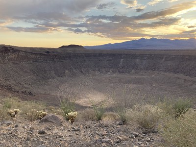
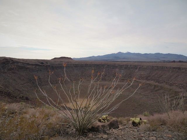
Our first stop inside the El Pinacate reserve is at the Sahuaro Danzante, a peculiar shaped arborescent Saguaro cactus. Our next stops for the day were at the mined cinder cone of La Laja, the spectacular El Elegante crater, with a diameter of 1,600 metres and depth of 250 metres, before stopping at the camping area known as El Tecolote (almost no light pollution on a clear day, so our accompanying student astronomer could easily point out the different stars, planets, constellations, satellites, etc. using her laser light after our BBQ with sandwiches, sausages and marshmallows).
El Pinacate has two kinds of volcano, a composite volcanic mountain that began erupting before 2-3 million years ago and ceased to erupt around 1 million years ago, and a distributed monogenetic volcanism that scattered nearly 500 cone volcanoes across the mountain and surrounding desert starting before the mountain was extinct. The monogenetic volcanoes, also called "cinder cones", were each built in a single, continuous, short eruption from its own unique magma. A few of the cone eruptions ended with magma mixing into ground water to create steam explosions that blasted large craters into the landscape, creating "maar calderas" far larger than any of the monogenetic cones.
The following day, just before sunrise we hiked up Cono Mayo for about 20 minutes to enjoy sunrise and the panoramic view over the Sonoran desert. After breakfast, we packed our tents and proceeded to the Cerro Colorado crater, a tuff-cone and a hydrovolcano without a maar caldera. After that, we headed towards the Schuk Toak Visitor Centre (the UNESCO WHS plaque and inscription certificater can be found here) and hiked to the dunes which are surrounded by mountains on one side and the sea on the other. After about 3 hours, we headed to the Puerto Penasco Malecon before driving back to Hermosillo and arriving around 11:30pm.
Overall, I was very happy with the whole tour and managed to observe quite a lot of flowering flora (some cacti flowers are only visible just before sunrise) and avifauna (ex. Gila Woodpeckers, Leconte's Thrashers, American Kestrels, Greater Roadrunners, etc.). I also managed to spot several butterfly species and caterpillars in the Gran Desierto de Altar dunes, as well as desert iron-claded beetles, darkling beetles, long-nosed leopard lizards, desert iguanas, chuckwallas, and a few round-tailed ground squirrels, desert cottontails and a black-tailed jackrabbits. The highlight species I managed to spot during my short visit was the Gila monster, a large venomous lizard.
Els Slots

EPGDABR, short for “El Pinacate and Gran Desierto de Altar National Biosphere Reserve”, is another rarely visited WHS in the far North of Mexico. After contemplating a lot of options on how to get there (Fly to Mexicali and rent a car? Take a bus the loooong way west from Chihuahua?), I stumbled upon a 2-day / 1-night camping tour out of the Sonoran state capital of Hermosillo. It ticked all my boxes as it would cover both the sand dunes (Gran Desierto) and the volcanic landscape (El Pinacate), provide transport & lodging, and it was cheap and convenient as well. This WHS is complicated in many ways, so brace yourself for a long review.
The first question that needs to be answered is “What is it exactly about?”. The landscape is a mix of volcanic craters, cactuses, high sand dunes, and starry nights, all in the Sonoran Desert. As the long name already suggests, it covers actually two adjacent areas with different values. I can see that for management purposes they have been linked, but it does feel like visiting two different sites. El Pinacate I would describe as “Iceland with cactuses”, while the Gran Desierto de Altar is like a smaller version of the Namib Sand Sea. The fabled “stark contrast of a dark-coloured area comprised of a volcanic shield and spectacular craters and lava flows within an immense sea of dunes” (OUV Statement) I found a bit prosaic, as the two areas only touch at certain points.
Its main volcanic features are the Maar craters: shallow craters formed by steam blasts. We visited Cerro Colorado (known for its colouring during sunset) and El Elegante (just a pretty one!). Note that it took at least an hour on a bumpy unpaved road to reach Cerro Colorado, and the other ones are even deeper inside the Reserve. The circuit is signposted, there are car parks and an easy hiking trail will get you to the edge of the craters. We didn’t encounter any other tourists during our visit to El Pinacate, we only met one park ranger on patrol by car.
There is a campground inside the park, in an area called Tecolote. It is nothing more than a flat area to pitch your tent plus a few benches and fire pits. It easily had space for our 15 tents. Only after a dog came begging in the evening when we had sausages roasting on the fire, we noticed that we had neighbours as well: 2 females (+ dog) in a van. The camp area also has two short trails and two smaller volcanic cones to climb.
In the 1940s and 1950s, parts of the area have been mined for its volcanic rock and pyroclastic material. It was used to build highway #2 and for construction purposes. Cinder mining has ceased since it was declared a national Biosphere Reserve, but it has left it with another colourful attraction. The Laja cone (photo) shows its rusty-red colours due to the high iron levels. The top of the cone has collapsed due to mining.
When you stand on top of one of the volcanic cones and scan the surrounding desert, your eyes cannot evade the brown stripe in the distance to the north. It is what the Mexicans call “The Wall of Trump”. Actually more a fence, it is the physical border that was built from 2020 on. As it limits the “connectivity and movement of key wildlife populations, such as the Sonoran Pronghorn and the Bighorn Sheep”, the WHC in its last session has urged the US and Mexico to an “assessment of impacts that the construction works might have already had on the OUV of the property”. Although I can see that the Mexicans find the whole construction an unnecessary provocation, it must be said that the aforementioned highway #2 on the Mexican side also is an eyesore with its continuous flow of white trucks. Many sheep will have been killed there as well. We did not see one mammal by the way, during our full 26-hour visit to the site.
The fence doesn’t only limit the movements of larger animals between Mexico and the USA, it was meant to prevent human migration. The Reserve’s Schuk Toak Visitors Center does focus on the story of the Tohono O’odham, the native people of the area. Maps show how they used a network of ancient salt trails to get around this barren region. One wonders whether the site couldn’t have been proposed as a cultural landscape as well.
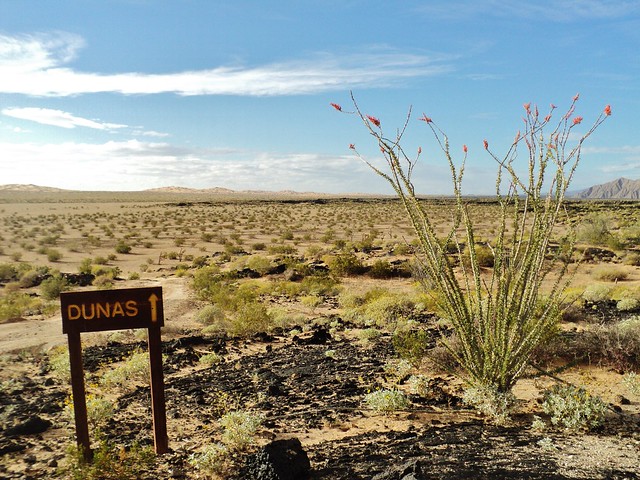
A few km beyond the Visitors Center, the sand dunes start. My tour mates liked this part of the tour the best, for me, it was a bit of “Been There, Done That”. It’s a hot walk for about 2km through the desert until you reach the golden sands. Its specialty is the very large star dunes, with sharp edges created by winds coming from many different directions. There were a few other US and Mexican day-trippers here as well, with a total of five cars in the parking lot.
In hindsight, I can think of 3 good ways of getting there & around:
- When you’re a confident driver on unpaved roads (with experience in Namibia and Botswana for example), you can explore the park in a rental car with high clearance. In case of need, there is cell phone reception in the areas on higher ground.
- You can do the same camping tour as I did. I found it well-organized. The amenities are fairly basic though, and the ride from and to Hermosillo is long (6+ hours).
- Base yourself in Puerto Penasco and try to find a full-day private tour with a driver/guide
I doubted whether to award the site with a 3.5 or 4-star rating. Usually, I reserve 4 stars for the WHS where I have a real WOW!-moment and can clearly see the OUV. Here I only had a short WOW! at El Elegante crater at sunset. The volcanic and desert features certainly are good, but are they globally outstanding? Both scores combined, I go for a 3.5. But anyway it is a very interesting and satisfying place to visit, that has left me pondering about so many subjects. And I even didn't start writing on the issue of land ownership... or the many species of cactus (including the 'dancing' saguaro).
Read more from Els Slots here.
Dan Pettigrew

I visited in April 2021 to El Pinacate. The Shuck Toak Visitors Center has a lot of good information about the area and it's history. I was the only one there that morning and they started a documentary in English in the theater for me. They informed me the reason the entrance to the loop road to El Pinacate was closed was that a property owner in the area was creating problems. They didn't explain what the problems were but that I wouldn't have been allowed anyway because I was traveling by motorcycle. With that development I chose to hike out to the dunes, the largest in North America. They have you sign a form when you go out and then again when you leave to make sure you made it out. I saw one other person out at the dunes and she was really impressed by them. I hope to have another chance someday to go out to the craters.
Kyle Magnuson
California - United States of America - 03-Jan-17 -
I began 2017 with a return journey to Sonora, Mexico and the stunning "Reserva De La Biosphera El Pinacate Y Gran Desierto De Altar". I was determined on completing two specific hikes/drives, which I missed during my first visit in March 2014. First, I wanted to hike to the dunes and second I wanted to see the reserves iconic otherworldly craters. We were graced with rain the previous night before our visit, which turned out to be a special surprise.
Here is the view from the dunes:

From the visitor center, you can take a 3km dirt road to a small parking lot to begin the hike. The road begins in a strange way, but its well-kept. the hike itself takes between 1.5 - 2hrs, depending on how often you take pictures and how far you want to go. Once you make it up to the summit of the nearby dunes you will have a great view of El Pinacate, and in the distance you can sea the Gulf of California.
No other hikers made the journey. In fact, only a handful of people made it to the visitor center in the couple hours we were in this section of the park. Most Arizona travelers are purpose-bound for the drinks and resorts in Puerto Penasco (Sandy Beach). I felt like I was the slowest driver on the highway, since I followed the (kilometer) speed limit, perhaps the Americans thought it was miles!
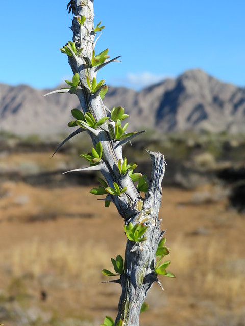
El Pinacate receives less than 4 inches of rain per year, and its just so happened a good portion of that rain fell the night before our visit. Unique results inevitably occur when rainwater is present in a park that's known for its dryness. For example, the Ocotillo cactus often produces green buds literally overnight. The sand and volcanic rock really absorb the water, and the color of the park is a bit different. Indeed, wildlife sightings are more common as well. We did spot a very fast jack rabbit, but little else with the exception of beetles and birds. Holding a sliver of hope in seeing the pronghorn or Desert Bighorn Sheep, we came away seeing some interesting footprints left in the moist sand. Realistically, its a long shot you will see any of the endemic mammals considering the reserve is over 1.7 million acres!
Now for the craters. Firstly, after some encouraging words from the excellent park ranger, I felt re-assured my sedan would be able to make the 3-4 hour circular route to visit the craters. My confidence was slightly misplaced! If you are in a truck, jeep, van or SUV you will be fine. However, for most sedans the dirt road, while certainly passable, is extremely bumpy and slow work in some portions. There was no danger of getting stuck or anything of that nature, but for about 27 kilometers to the first and greatest crater, El Elegante, it will be an uncomfortable and slow drive. The crater itself is stunning and you should hike the main course of the rim trail. However, in the end we decided not to complete the entire route to the other 2 accessible craters in fear of our vehicle, but also 3-4 hours can easily turn into 5 or more (if you enjoy the hikes).
I really love this reserve, and both portions deserve your time. I look forward to seeing which of you journey to this unique addition to the world heritage list. Visitors who have 3-4 days can comfortably visit 2 world heritage sites (El Pinacate + Islands of the Gulf of California).
Read more from Kyle Magnuson here.
Kyle Magnuson
California - United States of America - 03-Mar-14 -

Leaving Los Angeles at 5am, roughly 8 hours later my wife and I found ourselves crossing the border into Mexico at Lukeville, Arizona. No hassle and very quick. From here it takes 1hr to drive to Puerto Penasco, your right-side landscape is the El Pinacate Grand Desert Biosphere Reserve for most of this drive. There are 2 major access points to the reserve, one at the 72km mark, and the other at the 52km mark. Visitors will only access a small portion of this immense reserve, but the vastness of the land will leave a lasting memory.
The visitor center (recently built) is accessed at the 72km mark and is well-displayed by large signs. You won't miss it. The turn-off is a paved 7km road that ends with one of the most scenic areas of the reserve. The Schuk Toak visitor center is very much worth visiting and is a excellent facility to plan and learn about this incredible landscape. The staff are friendly and informative. There are short walks and medium hikes that traverse this area. The location was chosen specifically for its diverse and unique surroundings. Lava flows are everywhere, diverse plant species abound, massive sand dunes are reachable by a 45 minute hike, and views of El Pinacate are often superb.
You can happily spend 2-3 hours exploring this area. The fee for the reserve is 60 pesos ($5) and this fee allows visitors to explore both access points. After one completes their visit of the Schuk Toak area of the reserve, one can drive to the 52km mark and take the more ambitious route to explore some of the reserves wonders. Here at the 52km mark is a 76 km NON-paved loop road (dirt) that leads to some of the reserves massive craters (3 in total). The dirt road is maintained and passable to cars, but it does take at least 3-4 hours with stops.
Access to the dunes is from a short dirt road from the visitor center parking lot:
Therefore, visitors have 2 choices when exploring the El Pinacate reserve. Firstly, they can spend 2-3 hours enjoying and exploring the visitor center area. Secondly, if prepared, one can spend another 3-4 hours on a dirt road, viewing the representative craters of the reserve. Be prepared with water and a full tank of gas. Because of time constraints and some concern over our Toyota making the long dirt road journey, we limited our visit to the first access point.
El Pinacate is exceptional. The landscape, particularly in March is beautiful and very photogenic. Despite previous visits to several desert national parks/monuments in the United States (Death Valley, Mojave, Joshua Tree, Saguaro, Organ Pipe Cactus, Petrified Forest), I was never disappointed or letdown by this tremendous landscape. Indeed, El Pinacate in many ways incorporates many of the unique features of these diverse parks into one massive reserve. A worthy world heritage site, and accessible by car for US travelers based in Los Angeles, San Diego, Las Vegas, Phoenix, or Tuscon.
While I would be pleased to see the park extended to include the Organ Pipe Cactus National Monument in a transnational property, it is not absolutely critical to the protection of either area, and nor does it add vital areas of importance. Still a worthy extension, but probably not something we'll see in the near future.
Read more from Kyle Magnuson here.
Community Rating
Site Info
Site History
2013 Inscribed
Site Links
Unesco Website
Official Website
Related
In the News
Connections
The site has 23 connections
Ecology
Geography
History
Science and Technology
Timeline
Trivia
Visiting conditions
WHS Names
WHS on Other Lists
World Heritage Process
Visitors
23 Community Members have visited.
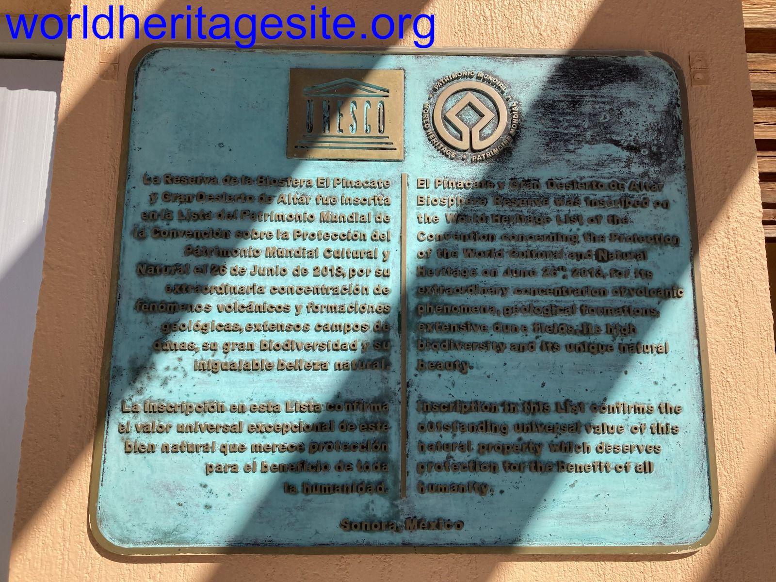
The Plaque
 (photo by Els)