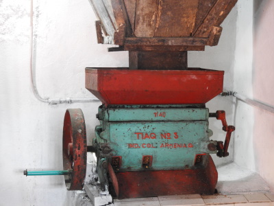
Al Ain
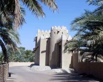
Cultural Sites of Al Ain: Hafit, Hili, Bidaa Bint Saud and Oases Areas are archeological sites representing sustainable human development in the desert since prehistory.
The Bronze and Iron Age remains show how a fertile environment was created on the Arabian Peninsula suitable for sedentary human occupation. The 17 locations include stone tombs, partially underground aflaj irrigation systems, oases, and mud-brick constructions.
Community Perspective: the sites are scattered around the heavily urbanised city of Al Ain. With a rental car they can be visited within one day if you plan well, some are accessible by public transport also. Worth visiting are the Al Ain National Museum with the Sultan Fort and the Al Ain Oasis next door, and the photogenic Al Jahili Fort. Solivagant in his review elaborates on the site’s somewhat disputed inscription.
Ancient villages of Northern Syria
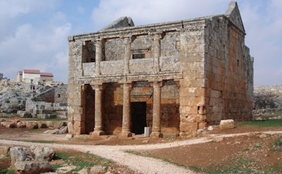
The Ancient villages of Northern Syria are the remains of rural societies from late Antiquity and early Christianity.
The inhabitants of this limestone mountain landscape gradually converted to Christianity. They were inspired by hermits such as Saint Simeon, who drew lots of pilgrims. Some 40 abandoned villages are included with often well-preserved monuments. Notable elements include the Church of Saint Simeon Stylites, Serjilla, an early Byzantine town, and the Pyramidal tombs at Al-Bara.
Community Perspective: this can be done as a day trip from Aleppo on private transport, it used to be quite popular under the name of “Dead Cities” with intrepid tourists. The area however has been ‘closed’ since the Syrian Civil War as it is in SDF territory.
Bridgetown
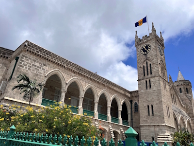
Historic Bridgetown and its Garrison represent a fortified port town designed by the British to safeguard their trade interests in the region.
Bridgetown was an entrepot for goods and enslaved persons, linked to the island's sugar industry and the rest of the Caribbean. The site comprises the old town, the port and the former garrison. The old town still has the medieval English-style street plan, and holds examples of creolized forms of architecture, including Caribbean Georgian. The former garrison protected the town and the port, and served as the headquarters of the British Navy in the region.
Community Perspective: Most reviewers find it underwhelming, but Sebasfhb and Clyde have more flattering things to say and consider the unique Screw Dock as one of the highlights.
Causses and Cévennes
The Causses and the Cévennes, Mediterranean agro-pastoral Cultural Landscape has evolved over three millennia due to farming and breeding of sheep.
It is located in the higher regions of the Massif Central, in an area of granite and limestone slopes and deep valleys. It is known for its chestnut farming and mulberry cultivation. Local breeds of sheep graze on open common land.
Community Perspective: The natural aspects of this area are much more appealing (and easier to recognize) than the agro-pastoral. See the reviews by Els, Hubert and Frederik for some ideas on what to see and do.
Citadel of the Ho Dynasty

The Citadel of the Ho Dynasty comprises the remains of a late 14th-century capital of Vietnam.
At the time when Neo-Confucianism became influential in his government, Prime Minister Ho moved the capital from the vulnerable Hanoi (Thang Long) to this more central countryside location. The city was laid out in harmony with the landscape according to geomantic principles. The walls were constructed from large blocks of stone, an answer to the invention of gunpowder in the hostile China.
Community Perspective: The site needs private transportation to reach. Look beyond the photogenic gate, to watch the farmers working their land within the boundaries of the citadel and check out the Nam Giao altar some 2km away. There’s also a small visitor center near the gate.
Coffee Cultural Landscape
The Coffee Culture Landscape of Colombia is a system of collectively cultivated coffee plantations in a mountainous landscape.
The area comprises 6 regions with a total of 18 villages and 24,000 small coffee farms. Together they account for around 35% of Colombian coffee production. The plantations and associated villages were founded in the 19th century and are still in use.
Community Perspective: the first reviewers tried to make sense of which areas exactly are part of the core zone, until Solivagant shed light on the matter. Els describes the particular way of coffee production that got the site inscribed, and Solivagant (in his 2nd review) highlights the coffee towns.
Fagus Factory
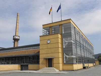
The Fagus Factory in Alfeld, an operational factory producing shoe lasts, is an important example of early modern architecture.
The group of buildings was built in 1911 by the architect Walter Gropius. Light was required for work purposes: this led to an almost entirely glazed building, via the innovative use of "curtain walls" (vast glass panels). The functionalist approach was a major break with the existing architectural and decorative values of the time and it is considered the starting point of the Bauhaus movement.
Community Perspective: Access to the main factory buildings is possible only on weekends by guided tour (though Ian got some VIP access!) – on other days you have to make do with the interesting exhibition in the former storehouse and the outside views of the glass panels.
Fort Jesus
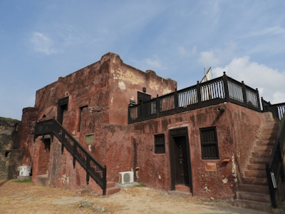
Fort Jesus, Mombasa is a fort built by the Portuguese to control the Indian Ocean trade.
The fortress was the first European-style fort constructed outside of Europe designed to resist cannon fire. Today, it is one of the finest examples of 16th-century Portuguese military architecture, which has been influenced and changed by both the Omani Arabs and the British.
Community Perspective: Worth about an hour. Your only choice to make is whether to hire a guide or not.
Hiraizumi
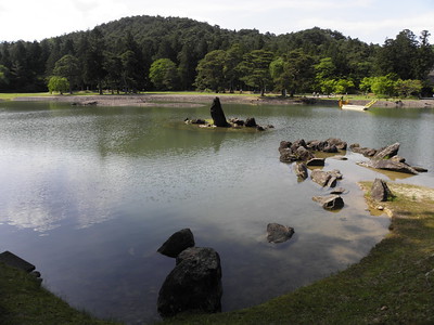
Hiraizumi –Temples, Gardens, Archaeological Sites Representing the Buddhist Pure Land comprises the ensemble of four gardens and a sacred mountain that is seen as a unique and influential example of planning and garden design.
Hiraizumi blossomed as a rival to Kyoto as the political and administrative centre of northern Japan in the early 12th century. These monuments were built by the ruling clan during this short-lived period. They mix indigenous Japanese concepts of nature worship with the ideals of Pure Land Buddhism, a branch of Mahayana Buddhism.
Community Perspective: “a mix of Kyoto temples in the location of Nikko, in a region with a lack of significant cultural sites compared to other parts of Japan”. Motsuji is deemed the highlight among the inscribed locations.
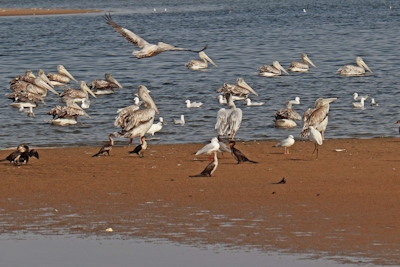
Kenya Lake System
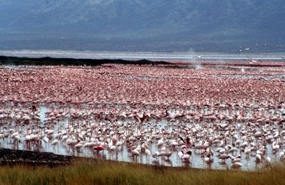
The Kenya Lake System in the Great Rift Valley consists of three soda lakes in the valley basin, known for their high concentration of Lesser Flamingo.
Lake Elementaita, Lake Nakuru and Lake Bogoria are shallow, alkaline, and are hydro-geologically connected through sub-surface seepage of water. The alkalinity of the three lakes supports the abundant growth of the green algae which is the food of the Lesser Flamingoes which congregate in the lakes in great numbers, and also attract breeding Great White Pelicans and migratory birds.
Community Perspective: try to find out beforehand which lakes have flamingoes at that time. The active and regular geysers and volcanic fumaroles are worth visiting too. Lake Elementaita is the easiest of the lakes to visit without a 4WD/with public transport.
Konso
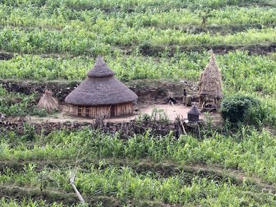
Konso Cultural Landscape represents a traditional way of living known for its construction of dry stone terraces and fortified towns.
The Konso people migrated to these highlands, where they constructed terraces to support agricultural fields. Their cultural tradition has existed for over 400 years in a hostile, dry environment. The area has 12 stone-walled settlements with thatch-roofed public structures and domestic buildings. The Konso are noted for their erection of memorial stelae called waka.
Community Perspective: Solivagant describes the history of its WH inscription and his visit to a village in 2007, while Wojciech visited Gamole village in 2022.
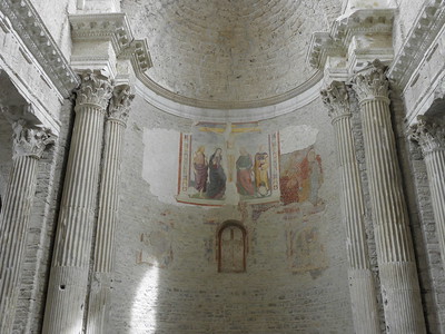
León Cathedral
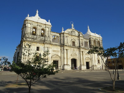
León Cathedral shows a regional interpretation of different church-building traditions.
The monument reflects the transition from Baroque to new architectural and artistic expressions typical of the 19th century, with Antigua Guatemalan touches. It is the largest Cathedral in Central America and, since 1531, one of the oldest dioceses in the Americas. Because of the strength of its walls, it has survived earthquakes, volcanic eruptions and wars.
Community Perspective: It’s a massive landmark covered in stucco plaster, with a sober interior. Two of the more interesting aspects can only be visited with a separate ticket: the roof and the cloister.
Longobards in Italy
"Longobards in Italy. Places of the Power (568-774 A.D.)" marks the transition between Antiquity and the European Middle Ages.
This heritage was left behind by the Longobard / Lombard elite, a people of Germanic origin who converted to Christianity. They supported the monastic movement but also were instrumental in transferring literary, architectural and other works from Antiquity to the Middle Ages. Their built structures show stylistic diversity.
Community Perspective: The serial site comprises 7 groups of monuments spread across Italy, of which you’d need to visit a couple to get the idea. Reviewed are Monte Sant'Angelo (Klaus, Matejicek), San Salvatore-Santa Giulia in Brescia (the best place to start; John, Els, Nan), Cividale del Friuli (Ian, Tom, Claire), Tempietto del Clitunno and San Salvatore in Spoleto (Clyde, Els, Tom, Nan), Castelseprio-Torba (Els), and the Santa Sofia Complex in Benevento (Aspasia).
Meroe
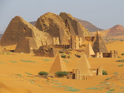
The Archaeological Sites of the Island of Meroe contain the best-preserved relics of the Kingdom of Kush at the height of its power.
Meroe became their capital in the 3rd century BCE, with its proximity to the Nile making it a viable location for human existence. The three components include the town of Meroe and its cemetery, and the associated sites Musawwarat es-Sufra and Naqa which are located in the desert further from the river. As the site of royal burials, most notable are the more than 200 Kushite pyramids that have survived.
Community Perspective: It doesn’t lie too far from Khartoum, so it is more often visited than Gebel Barkal. The focal point is the pyramid field of the Meroë Necropolis, but don’t miss Musawwarat (it has a finely restored temple and magnificent carvings) and Naqa (where the Kushites showed that they'd been in contact with Roman / Hellenistic structures).
Ningaloo Coast

The Ningaloo Coast holds a fringing coral reef known for its seasonal feeding concentrations of the whale shark.
Due to seasonal nutrient upwelling, a group of 300-500 whale sharks gather here yearly. The marine area also is rich in coral, reef fish, mollusc, turtle and crustacean species. Adjacent to Ningaloo Reef, the limestone karst landscape of Cape Range has a remarkable density of underground caves and other karst features, providing a habitat for birds and reptiles.
Community Perspective: This is a hard-to-reach site, but it still is popular with the diving crowd. Zoë has described such a scuba diving trip. The best chance to see a whale shark is from mid-March to the end of July.
Ogasawara Islands

The Ogasawara Islands are a group of oceanic islands that display the evolution process since the birth of the islands.
The forested landscape holds plant species of both Southeast Asian and Northeast Asian origin. It is a habitat for endemic and endangered species, including the Bonin Flying Fox, a critically endangered bat. Also remarkable are its 134 species of land snails and its variety of vascular plants.
Community Perspective: Zoë has been the only reviewer so far, and she reports back on an expensive group of islands with ample opportunities for hiking and sea-based activities such as diving and snorkeling.
Persian Garden

The Persian Garden comprises a set of gardens that have influenced garden design from Andalusia to India and beyond.
Persian Garden design is dominated by geometry and the use of water as a central element. They derive from the Chahar Bagh model: the division of a site into four sectors, opening out into the four cardinal directions. The site comprises nine gardens from different epochs and climates.
Community Perspective: You’ll likely come near one of these nine gardens when travelling in Central Iran. Bernard, who visited 3, found them “humble, modest and unpretentious gardens”, while Joyce, who managed 6, recommends not visiting in the wintertime.
Petroglyphs of the Mongolian Altai

The Petroglyphs of the Mongolian Altai comprise the largest, oldest and least damaged concentrations of rock art at the intersection of Central and North Asia.
The petroglyphs are spread out across three components over a large area in mountain valleys at the remote western edge of the Altai mountains. The earliest images date from the Late Pleistocene (11,000 years BP). They extend into the Bronze Age, Iron Age and Turkic period (9th century). The images evoke historical cultural landscapes and lead to a better understanding of pre-historic communities in this area of Asia.
Community Perspective: this site has been unreviewed so far.
Prehistoric Pile Dwellings
The Prehistoric Pile Dwellings around the Alps are the remains of prehistoric agrarian lake shore communities.
Rising water levels since prehistory led to the abandonment of these stilt house settlements. Covered by lake and river sediments, organic materials such as wooden structures have been preserved. Archeological findings further include the oldest textiles discovered in Europe, dugout canoes and wooden wheels. About 30 different cultural groups were responsible for creating these pile dwellings.
Community Perspective: only at very few of the 111 locations can original remains be seen, at the others, you will be staring “intently at the water trying to spot the merest hint of some buried rotten wood”. Molina di Ledro and Fiave in Italy are your best bets. Solivagant contemplates what a visit to the Pile Dwellings entails, and Hubert has visited multiple locations.
Residence of Bukovinian & Dalmatian Metropolitans
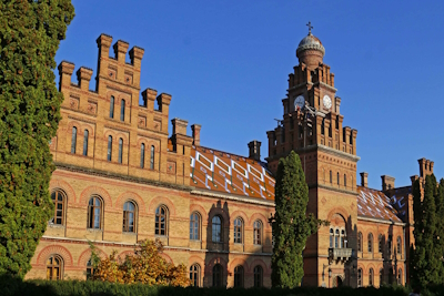
The Residence of Bukovinian and Dalmatian Metropolitans is a 19th-century example of historicist architecture.
The complex was the seat of the (arch)bishopry of the Bukovinian Orthodox Church, which developed while this region was under Austrian Habsburg rule and lasted til 1940. In addition to Gothic and Baroque architecture, Byzantine forms were used, mixed with decorative patterns in the local folk tradition. It now is in use as a University.
Community Perspective: The complex lies on the outskirts of the charming historic town of Chernivtsi, close to the Romanian border. The interior of the buildings can only be seen on an organized tour (in Ukrainian), which seems to be conducted on a regular basis.
Saloum Delta
The Saloum Delta is representative of a traditional coastal lifestyle of shellfish gathering and fishing in brackish water.
The site holds numerous shellfish mounds, some of them several hundreds metres long. They were produced by humans over a period of 2,000 years and form a structure of reclaimed land. Several of them hold funerary sites (tumuli).
Community Perspective: The shell mounds are impressive - if you manage to see them within this wide area. They can best be reached from Toubacouta (Jarek), where boat rides are on offer. Another option is Djiffer (Thomas), although more geared towards the (uninscribed) natural features of the Delta. Squiffy reports of an entirely nature encounter in Fathala Forest (within the core zone).
Selimiye Mosque
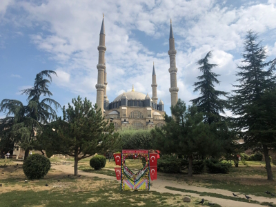
The Selimiye Mosque and its Social Complex in Edirne are considered the pinnacle of the career of the most famous Ottoman architect, Sinan.
The mosque was built between 1569 and 1575 and owes its beauty to the symmetry of the building and the optimal lighting inside. It has a large dome surrounded by four 71-meter-high minarets. The adjacent building complex has a social function with a religious background and includes two madrasas, a bazaar, a courtyard and a library.
Community Perspective: Edirne is a pleasant city and worth staying overnight in (don’t do it as a day trip from Istanbul, see Nan’s review why). The mosque has been under renovation for a long time now, but even then it is worth visiting as Els reports.
Serra de Tramuntana
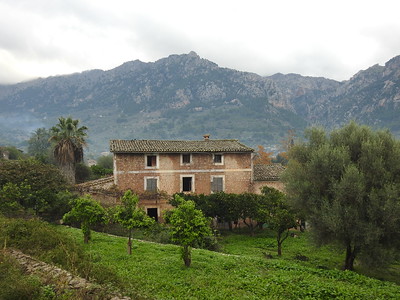
The Cultural Landscape of the Serra de Tramuntana is a man-made agricultural landscape on a mountain range on Mallorca.
Olives, grapes, and oranges were and still are grown on the farms. The land has been made productive by the construction of agricultural terraces and irrigation canals in the Arabic tradition. In addition, towns, villages, churches, and chapels were founded.
Community Perspective: The Serra de Tramuntana is mostly worth a visit because of its sometimes stunning landscape. Solivagant wonders however where its "cultural landscape" status has come from, while Els tries to distinguish what's in the core zone and what isn't.
Wadi Rum
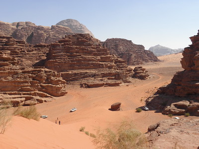
The Wadi Rum Protected Area is a true desert landscape with iconic landforms and traces of ancient human habitation.
The landscape was created by tectonic activity and further shaped by erosion, resulting in natural arches, mushroom rocks, narrow gorges and spectacular networks of honeycomb weathering features. The area has been inhabited by many human cultures since prehistoric times, including the Nabateans. They left rock art and ancient Arabian inscriptions.
Community Perspective: Some reviewers have resented the persistent Bedouins selling 4x4 tours of the area, but you have to succumb to one to get a rewarding visit (look up an agency with good reviews beforehand). A day tour (as described by Els) will bring you to a circuit of sights including both petroglyphs and natural features such as arches, an overnight stay (as done by Jay and Squiffy) will add hikes, camel rides, Bedouin hospitality and a starry sky.
West Lake
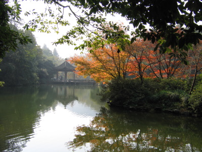
The West Lake Cultural Landscape of Hangzhou is an implementation of the classical Chinese landscape aesthetic ideal by improving the natural landscape
The natural lake has been made more beautiful with bridges, pagodas, causeways, pavillions, ornamental trees, etc to demonstrate the harmony between man and nature. The 'improved' landscape had a profound impact on the design of gardens and landscapes in and outside of China.
Community Perspective: Frederik has written a good introduction to this site, while Nan added more ideas and tips for using public transport to get to the lake.
Extended Sites in 2011
Primeval Beech Forests
The Ancient and Primeval Beech Forests of the Carpathians and Other Regions of Europe show the expansion and genetic adaptability of the European beech since the last Ice Age.
They comprise the largest remaining forests of the European beech ('Fagus sylvatica') across 18 countries. They also hold the largest and tallest beech specimens in the world. The European beech is a very adaptable species and it is spread across areas of different altitudinal zones, with different climatic and geological conditions.
Community Perspective: “I would like this beech forest madness to stop.” – this cry from Philipp seems to sum up the verdict on this WHS nicely; Caspar also shares some philosophical insights on the matter. But reviewers keep being drawn to its many locations. An inventory of the reviews results in 14 parks ‘ticked’: Vihorlat (Slova) – Els, John, Petteri, Matejicek; Stuzica (Slova) – Jarek, John; Hainich (Ger) – Hubert, John, Ian, Nan, Adrian; Kellerwald (Ger) – Peter, Clyde, Solivagant, John, Nan, Adrian; Grumsin (Ger) – Boj, Tsunami, Adrian; Jasmund (Ger) – Thijs, John, Michael, Matejicek, Nan, Tsunami, Adrian; Serrahn (Ger) – Adrian; Sonian Forest (Bel) – Els, Caspar; Monte Cimino (Ita) – Matejicek; Foresta Umbra (Ita) – Matejicek; Bieszcziady (Pol) – Matejicek; Jizera (Cz) - Matejicek; Bettlachberg (Swi) – Philipp, Adrian; Mavrovo (NMac) – Chris.
Els Slots The Netherlands - 26-May-08

In preparation for my visit, I had a difficult time finding any practical information about the nominated properties in Slovakia. My guidebook has nothing of any value on them but does include a handy map called 'Snina wooden churches' that covers the same area. The IUCN evaluation holds a shady map, which seems to point out only 3 properties on the Slovak side instead of 4. A better bet for maps is the Slovak/Ukrainian nomination dossier. I also found a regional website that has information about villages and parks. It describes access to the Vihorlat Protected Landscape via the village of Zemplínske Hámre. So I turn this route into the goal for myself today, possibly (weather and other circumstances permitting) with a walk to Morské Oko lake.
Read On