Upper Sepik River Basin
Upper Sepik River Basin is part of the Tentative list of Papua New Guinea in order to qualify for inclusion in the World Heritage List.
The Upper Sepik River Basin holds an undisturbed region of freshwater and rainforest, inhabited by numerous culturally diverse groups. Its fauna is especially notable for its endemic birds and fish. Culturally, the architecture of the gabled spirit houses stand out.
Map of Upper Sepik River Basin
Load mapThe coordinates shown for all tentative sites were produced as a community effort. They are not official and may change on inscription.
Community Reviews
Solivagant

As is often the case, the extent and possible boundaries of this T List site are not at all clear. Although the title refers to the “Upper Sepik”, the UNESCO description simply states that it covers “the middle and upper reaches of the Sepik River basin including slopes of the Central Range”. We are also told that the area is “the size of France”, whilst topographic names are limited to “the Hunstein Range Wildlife Management Area” (WMA) and the “Telefomin region”. We visited this general area in Sept 2007 - but I had always steered clear of doing a review for fear of discovering that we hadn't visited the actual TWHS! However, recent “research” I have carried out (more later) means that I now feel confident of making a valid review of it, as well as adding to the “knowledge base” about Papua New Guinea's (PNG) TWHS on this Web site.
At the time of writing, information here about PNG as a whole is very “thin” - few visits, fewer reviews, no Forum topic and no links to other informative Web sites or “News”. Yet Port Moresby (PM) is only a 1.5 hour (525 mile) flight from Cairns!! Of course you first have to get to N Queensland and then go on somewhere from "unlovely PM". Ex Europe, flights with Singapore Airlines, code sharing with Air Niugini through to PM are the most direct route – but still VERY expensive compared with other World-wide destinations. And then PNG’s reputation isn’t “good” – theft and violence, expense, travel difficulties……and, for those prioritizing “WHS ticks”, there is currently just the 1 at Kuk with not a lot to see!
It may be true that most of the violence is inter-tribal, but PNG is only the second country in the World where I have been “mugged” (The Gambia being the other). Some might say that being mugged once is unfortunate but being mugged twice smacks of carelessness! Perhaps? It occurred just outside the Goroka show whilst photographing locals getting “made up”. It was neither overcrowded nor isolated …luckily the knife was aimed at my camera strap and not at me ….. and I did get the camera back (though that’s another story….!) with which to take the most amazing photos throughout the trip. True, I got no WHS ticks (despite being only a few kms from the then un-inscribed Kuk) but I can “claim” the T List “Upper Sepik” - and very fine it was too, so don’t let my “mugging experience” put anyone off!!
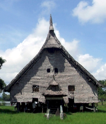
The Sepik is PNG’s longest river - at 1136kms, almost as long as the Rhine (but with nearly 2.5 times as much water discharge). It first flows westwards in the highlands, turning north and criss-crossing the "straight line" Irian Jaya border before dropping and flowing east again for the majority of its meandering length in a vast flood plain which, 6000 YBP, was a shallow sea. Along this plain it is joined by a series of tributaries flowing mainly from the south. The terms “Upper”, “Middle” and “Lower” do not appear to have agreed geographic definitions but the “Middle Sepik” generally seems to be regarded as constituting a stretch of the flood plain from around Pagwi to the confluence of the Yuat River - and is undoubtedly the correct term for this site. It is perhaps worth mentioning that, in cultural terms, the Lower. Middle and Upper Sepik differ significantly, with each having its own tribes and languages. The Middle Sepik lives off subsistence farming and fishing and is particularly famous for its giant “Spirit Houses” or “Haus Tambaran” (photo), for its tribal Art and for the beliefs and practices (e.g "Scarification") which (to some extent) continue. Each village is different and this Web site gives an idea of the artistic specialities and of the villages involved.
But how best to visit? I have met people (particularly birders) who have traveled independently in PNG but, for those with limited time and a desire to get to several of the more “remote” areas across it, then use of a local agency is required. We chose the reasonably up-market “Trans Niugini Tours” (TNGT). It has its own light planes, hotels and a boat on the Sepik, so could provide an “end to end” route across several areas of PNG. The “result” for its customers is of course not “adventurous” at all - but really rather comfortable!! The Hotel into which one flies for the Sepik is at Karawari Lodge. Its main section is designed as a “Haus Tambaran” and is packed with fine examples of the local art – very stylish (although not really “luxurious”!). We then had a 3 night “cruise” on the “Sepik Spirit” traveling down the Karawari/Blackwater rivers into the main Sepik before flying out of Timbunke. This mission town is connected by roads from Wewak for those who want to travel independently or take a land based tour using local river transport. There are no roads on the southern side of the Sepik.
The "Sepik Spirit" pulls with it a small but speedy flat bottomed “tender” to reach otherwise inaccessible villages within the many shallow lakes in the area which would otherwise be inaccessible to the main boat. Each day contained several “Village visits” with plenty of opportunities to find out about/see aspects of village life/beliefs/customs etc and interact with the locals with or without local guides as intermediaries (we were just 14 people and, once in a village, didn’t have to move as a group all the time). The main “event” at each was to visit the “Haus Tambaran” (Female “tourists” were allowed in despite the Taboo on that for locals!!). Inside are carved beams, sacred drums, flutes, masks and costumes - their meaning and purposes require lengthy explanation but this Web site gives a flavour. Similarly styled (but usually rather smaller!!) articles were offered for sale – but without any pressures. There would also usually be a cultural dance/music show or activities like making semolina!
We have experienced such “tribal visits” around the World and it is always a difficult line to tread between partaking of “poverty porn” and being genuinely interested in learning about other cultures and contributing at least something to them. This type of encounter raises many issues. The "exchange" is undoubtedly "unequal” - but is it too “unfair”? How “authentic” is what is on show and is this type of visit helping to preserve heritage or is it actually altering/destroying it? These people were clearly "poor" by "Western" measures compared with their visitors but many would have been quite wealthy in terms of local measures of pigs, yams, shells, wives (!) etc and there were no signs of the abject poverty/malnutrition/poor health etc which can be experienced in Africa and the Sub Continent. We found the villagers to be “friendly” and there was no hint of the difficulties or taboos regarding “strangers” entering property for which PNG is infamous. Neither did I sense any undercurrent of dissatisfaction regarding our presence and what they perceived was “expected” of them. TNGT would, of course, have made negotiated recompense for the visit to be taken from our payment to them and this avoided all the awkwardness often associated with individual visits to such cultures.
Looking back on our PNG visit, the intangible cultural aspects which we viewed and learned about provided a major "take out". The assessment of "Value" as described above (and what makes a "big man"!), the concept of "Pay back" (particularly the local "banking system" operating with "Pigs" as "currency" and sources of credit!), the inter-tribal conflicts (and what people will do for group loyalty including resorting to violence), the "customary justice" system operating for many aspects of life "outside" more (and not always relevant) "Western" concepts as operated by "remote" central government), the syncretic nature of the received Christianity (do visit the churches as well as the "Haus Tamborans"!), the public notices in Tok Pisin giving an indication of the presence of issues like wife beating and corruption......These were not simply the "strange" practices of "far away peoples" but reflections of very similar aspects (albeit with different practices) within "European culture".
Although the T List entry indicates that the site would be nominated as a “Mixed” WHS, the journey we made concentrated almost entirely on the area’s “Cultural values”. Karawari is situated at the start of the forest/higher ground and would probably be the best of the places we visited to do serious “nature viewing”. Of course there are “ordinary” PNG birds everywhere, but that wasn’t the focus of our “River voyage”. We didn’t visit any WMA and no expert “Wildlife guide” was provided. We might have “missed out” on some things, but generally it didn’t matter to us - we were getting enough (for us) Birds of Paradise etc elsewhere in PNG. (Indeed, later on at Rondon Ridge we actually got the same guide as had appeared with David Attenborough to help him see Birds of Paradise!).
So. how am I confident that our visited area does lie inside the current T List boundaries? I have come across this report of Jan 2015 (Peter Hitchcock & Jennifer Gabriel - the former, who died in 2019 was an internationally respected environmentalist, who was also a doyen of IUCN and a long term participant in World Heritage nominations and site management) which reviews all 7 of PNG’s T List sites in detail including their boundaries where defined (No doubt Els will now add it to the DB!). For the Sepik see “Boundary Description” on Page 174 and maps on pages 175 and 189/90. These indicate that the included area of the T List site includes all of our “Middle Sepik” journey from Karawari to Timbuke (and does use the Yuat river as the eastern boundary), but doesn’t include the headwaters of the Sepik in the mountains around Telefomin. Rather it is concentrated on the upper flood plain and rivers flowing into it from the south. This confirms that the current titling of "Upper Sepik" is inaccurate - but of course that sounds so much more "remote" and "adventurous" than does the mere "Middle Sepik River basin"!! Only a single contiguous area was envisaged and the current “dot” on this Web site’s map at the centre of the Hunstein Range WMR (Now a part of the bigger “April-Salomi FMA”) is reasonably placed geographically but doesn't really capture the extent of the surrounding areas which have been included largely for "Cultural rather than "Natural" reasons. The dot at Telefomin village is certainly outside the defined area (The UNESCO description’s reference to “Telefomin Region” refers to parts of that sub-district on the northern side of the Central Range). The dot at Korogo identifies a (random but significant) village/"Haus tamboran" within the boundary but should perhaps be removed altogether or replaced by one further to the East to represent that area?
The report also identifies a major aspect of “value” not mentioned at all in the UNESCO description in the form of Cave Paintings in the Upper Karawari area which had only been identified and studied since 2006 and could constitute “the greatest example of rock art in the whole of Melanesia”. At this point the report wonders whether the caves might not be better dealt with as separate nomination - but concludes not. A similar point could be raised about the mixing of cultural and natural aspects across such a large area when these aspects are significantly (albeit not totally) geographically separated. At the moment it seems a bit like proposing a single WHS for e.g the entire "Garonne Basin" mixing all the natural, cultural and Cultural landscapes into a single giant WHS! Apparently it is envisaged that the site would claim 8 different OUV criteria (Missing out ii and vi). Currently only Mt Taishan and Tasmanian Wilderness have achieved 7. PNG has adopted the "Mixed site" approach across all of its 7 T List sites. But what tangible cultural OUV would be claimed for the Upper Sepik? I note that we have categorised it as a "Continuing CL" - but neither the current UNESCO description, nor the T List Review Report mention "CL" for it anywhere. The "Haus Tamborans" are clearly structures with significant OUV - but there isn't a lot of obvious further "tangible" value in the villages and their fields. That hasn't of course prevented many areas of Africa being inscribed as CL and a similar approach would no doubt identify many further aspects of the wider landscape as having "Cultural value".
The report’s biggest concern relates to a proposed Copper Mine in the Upper Sepik. This was forecast to commence production “not before 2016” but hasn’t yet even commenced construction. However, planning permission is still actively under consideration by the PNG government with the request coming from a company which is now 80% Chinese owned via Australian and other subsidiaries. Infrastructure developments, tailings disposal, barge traffic (already a problem from logging) etc all threaten the River and the Basin area. The mine and a WHS for the Sepik seem incompatible…. And that is what those who are campaigning against the mine believe - so they are currently pushing for a Nomination of the Sepik to be actively pursued (See "The Way Forward" and the "claim" of "legal personhood" for the River).
Whatever happens regarding the mine, one can be sure that the Sepik area will undergo major change (and I can see from recent reading that it already has done so in the 15 years since our visit). Its peoples need and deserve improvements to all aspects of their lives. I am just glad that we saw the area in 2007! Anyone who hasn’t yet seen it might be advised to do so as quickly as they can.
Site Info
- Full Name
- Upper Sepik River Basin
- Country
- Papua New Guinea
- Added
- 2006
- Type
- Mixed
- Categories
- Cultural Landscape - Continuing Natural landscape - Diverse ecosystems
- Link
- By ID