Wanuskewin
Wanuskewin is part of the Tentative list of Canada in order to qualify for inclusion in the World Heritage List.
Wanuskewin features topography that is unusual for the Great Plains of North America. A deep and wide valley cuts through the otherwise flat prairie, offering sheltered terraces and coulee depressions alongside a source of fresh water. Within this small radius are nineteen Pre-Contact archaeological sites that offer a complete record of cultural development on the Northern Plains, spanning 6,400 years. Habitation sites, bison jumps and pounds, tipi rings and the northern-most Medicine Wheel recorded in North America narrate the varied uses for the site, and demonstrate an evolution of land-use and methods for survival. Nowhere else is there such an extensive record in such close proximity.
Map of Wanuskewin
Load mapThe coordinates shown for all tentative sites were produced as a community effort. They are not official and may change on inscription.
Community Reviews
GabLabCebu

Wanuskewin is not the kind of place you simply stumble into; it's a site one would usually have to make quite a journey for. Most definitely, it once drew Native Americans in far greater numbers than it does today's tourists. However, I was lucky enough to visit Western Canada in July 2024 and figured it was the perfect time to make the journey all the way out here. A journey it was! Unless you live in or frequent Saskatchewan, it's a 6-hour drive from the big cities of Alberta over endless fields of grass, corn, and canola. At least Prince Albert National Park is just about a 2-hour drive away, to make the journey more worthwhile.
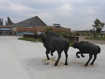
Located just outside Saskatoon, Wanuskewin feels a lot more rural and isolated than it really is. Many visitors probably just end up at their visitor center, which has a good exhibition on the site and the associated First Nation cultural heritage, as well as a great restaurant serving Native American cuisine. Others may be drawn by the opportunity to see their bison herd (personally, I'd suggest Elk Island National Park near Edmonton for that). The main draw for World Heritage Travellers, however, is the hiking circuit that takes you around the site to various scenic, historic, and spiritual points of interest. A quick overview of the historic points at a fairly fast pace took me an hour; a thorough and relaxed experience of the whole area could take 2-4 hours.
Looking at the map I was provided, the highlights for a historic tour seemed to be a bison jump, a bison rubbing stone, a bison pound, tipi rings, and of course the northernmost medicine wheel. The bison jump site was pretty much just down the valley from the visitor center, and its view was mostly blocked by overgrowth. The bison rubbing stone was perhaps the most interesting site, featuring an extremely smooth and polished boulder in the middle of a small grassy plateau on the opposite side of the river. It turns out that the bison herds would rub their horns on the rock, polishing it over the millennia. My excitement to see the remaining sites, however, turned to disappointment as I passed them one by one; there were only signs that marked their sites, but no sign of the archaeological findings could be seen (perhaps just to my untrained eye, but I really did scour every inch of the ground I could see). Neither was there any comprehensive explanation of what was found in these places and their significance. In fact, most signs in Wanuskewin's points of interest seemed to cater more to the spiritual aspect, trying to illustrate the viewpoint of the natives that once inhabited the area. I mostly just enjoyed the rubbing stone and the many viewpoints of the landscape, though to say the site stood out for scenic beauty or uniqueness would also have been a stretch. To many, it would just be another little valley snaking through the prairie.
Back at the visitor center, some of the archaeological findings were on display. Most notable was a stone with a petroglyph uncovered by the reintroduced bison in the area (see picture). The visitor center is also a cultural center for the indigenous cultures, and natives do talks and performances there regularly to educate the general public. Displays also go into detail about the site’s journey to World Heritage status. It is indeed a very significant site for natives and archaeologists. Personally, I’m just not a fan of sites whose OUV lies mostly in its removable artifacts. Better examples of bison jumps and pounds and tipi rings can also be observed at Head-Smashed-In. The medicine wheel was especially disappointing to me because the staff had informed me not to take pictures of it because of its sacred nature, but when I arrived, I genuinely couldn’t tell what I was supposed to not take a picture of… all I could see was grass. While the breadth of archaeological timing and findings is impressive, I simply don’t find any single thing too exceptional here. Most especially, the lack of tangible observable remains for visitors to see in situ really made it hard for me to appreciate Wanuskewin as a future WHS. That being said, it still wouldn’t surprise or annoy me too much to see this inscribed soon. It is definitely unique and may fill a niche in the WHS list. If any of you make the trip out here, make sure to leave room for their bison dishes!
Site Info
- Full Name
- Wanuskewin
- Country
- Canada
- Added
- 2018
- Nominated for
- 2028
- Type
- Cultural
- Categories
- Archaeological site - Pre-Columbian
- Link
- By ID
Site History
2024 Preliminary Assessment
2018 Added to Tentative List
Site Links
Visitors
7 Community Members have visited.