Cara Sucia / El Imposible
Cara Sucia / El Imposible is part of the Tentative list of El Salvador in order to qualify for inclusion in the World Heritage List.
Cara Sucia / El Imposible comprises a mixed proposal of a pre-Columbian archaeological site and the largest extant forest in the highlands of El Salvador. It used to be a regional center of the Cotzumalhuapa culture. The site holds an acropolis, two enclosed ballcourts, and a 14-meter-high pyramid, as well as several minor pyramids and platforms. They were made of large river cobble stones. The site is now mostly overgrown and has been subject to looting.
Map of Cara Sucia / El Imposible
Load mapThe coordinates shown for all tentative sites were produced as a community effort. They are not official and may change on inscription.
Community Reviews
Dennis Nicklaus

My daughter and I really enjoyed our visit to El Imposible in January 2023 and we had a really good hike here. We were driven up the same terrible access road that Els described, and I think we went to the same ranger station/mirador for the start of our hike. However, we hiked all the way down to the bottom of the gorge to the confluence of two rivers. After some fun exploration along the boulders and streams and swimming in the little pools there to cool off, we of course had to hike back up, about 7 miles round trip. A sign at the top says you're at 780 meters above sea level, so it was maybe 500 meters elevation change? The forest was enjoyable and we had a good local guide for the interpretive plant trail that was pretty interesting. But it is far from virgin forest as most of the area where we hiked used to be a coffee plantation, we were told. This seemed to be a pretty standard tour for El Imposible, but I was disappointed that our tour didn't even include the "impossible" bridge that the park is named after. I think there are many other hikes you could do, and I think there might be adrenaline sport activities inside the park boundaries in other spots. I don't think the part of the park that we saw was really WHS worthy, but maybe other parts are better. Our tour guide (who we'd used for a tour of Maya sites of El Salvador) suggested that we'd enjoy a hike through El Salvador's Montecristo cloud forest better. In any case, it was nice to explore a part of the country that most people don't visit.
Since it was such a long drive from Santa Ana as a day trip, I couldn't convince our driver/guide to make a detour to the Cara Sucia ruins site, unfortunately, and he couldn't even determine that they were actually open to the public. Also, on the terrible access road, on the way down, a pickup truck was broken down in the middle of the road, and we were just *barely* able to squeeze by on one side to get around him. I would not have wanted to be the one driving that road!
Els Slots

At first sight, there isn’t much potential in El Salvador’s Tentative List. I did visit a couple of the sites though, just to get a feel for different parts of this small country. I choose El Imposible because of its intriguing name. It lies in the “far” northwest of the country. This national park shares its entry with the Cara Sucia archaeological site in the nearby larger town, which I did not visit. The name “El Imposible” comes from the time when this was a cacao farming area. The mules had a hard time crossing a difficult mountain pass that would bring the product to the ports at the Pacific Ocean.
I went there with a car+driver from San Salvador. It’s only a 115 km drive, but El Salvador has a serious traffic problem (probably related to its high population density) and the final 13km to the park are on a very bad unpaved road. So it took us about 3 hours. There’s even a local bus that struggles up the road! This last stretch also introduces you to what El Salvador once was. I really enjoyed watching the people here, the older men proudly wearing their machetes, and the women carrying a small bag of flour fresh from the mill to prepare lunch. The traditional wooden houses now are often replaced by stone ones, funded by money sent home from the US (“to show off”).
The park protects the largest extant forest in El Salvador. It has a visitor center and park guides. They are all geared up to receive a steady flow of visitors, but the terrible access road does not help, as is the hot and dry climate (my driver said that local tourists prefer to go somewhere cooler as it is always hot in the cities as well).
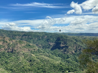
With my guide Rosa I set out for a short walk. We went up to the first Mirador and then the same way back. It was a fairly flat and easy forest walk. The forest is so dense, you see little else than trees. It was a very windy day and the birds did not show, except for a few raptors that could be seen from the Mirador. The king vulture is the park’s flagship species. There were a few pretty and large butterflies around, especially one with green/beige camouflage.
The Mirador also is the point where you can see the sheer size of the forest. If there is any OUV, it should come from its plant species. A few trees are showcased on an interpretative trail, such as the chaparrón and ojushte (breadnut), both with medicinal qualities. And the non-native bambu from cacao times.
Read more from Els Slots here.
Site Info
- Full Name
- Cara Sucia / El Imposible
- Country
- El Salvador
- Added
- 1992
- Type
- Mixed
- Categories
- Archaeological site - Pre-Columbian Natural landscape - Forest
- Link
- By ID
Site History
1992 Added to Tentative List
Site Links
Locations
The site has 2 locations