Switzerland
Swiss Tectonic Arena Sardona

The Swiss Tectonic Arena Sardona is a significant example of the process of mountain building.
The Tectonic Arena contains a major break in the Earth's crust: the Glarus thrust. It is a clearly exposed and well-accessible example of thrust faults in general, and has as such played an important role in the development of geological knowledge on mountain building.
Community Perspective: To see the whole area you can hike from Elm to Flims – a tough hike of 21.5km if you do it in full (Nan can probably still feel his legs). Lazier people can (like Els did) go and reach the Fil de Cassons from Flims by chairlifts and a cable car ride, but Ralf recently has reported that this route is under construction until at least the end of 2024.
Site Info
Official Information
- Full Name
- The Swiss Tectonic Arena Sardona (ID: 1179)
- Country
- Switzerland
- Status
-
Inscribed 2008
Site history
History of Swiss Tectonic Arena Sardona
- 2008: Inscribed
- Inscribed
- 2005: Requested by State Party to not be examined
- As Glarus Overthrust
- Type
- Natural
- Criteria
- viii
Links
- UNESCO
- whc.unesco.org
- Official
-
- unesco-sardona.ch — Sardona Welterbe
- Related
-
- en.wikipedia.org — Wiki on Glarus thrust
All Links
UNESCO.org
- whc.unesco.org — whc.unesco.org/
Official Website
- unesco-sardona.ch — Sardona Welterbe
Related Resources
- en.wikipedia.org — Wiki on Glarus thrust
Community Information
- Community Category
- Natural landscape: Glaciation
Travel Information
Recent Connections
-
IUGS Geological Heritage Sites
Glarus Thrust -
Suspended cable cars
Cable car Elm-Tschinglen / 1964 / 1,496… -
Tectonic processes
Criterion (viii): .. The Swiss Tectonic…
Connections of Swiss Tectonic Arena Sardona
- Geography
- Ecology
-
-
Tectonic processes
Criterion (viii): .. The Swiss Tectonic Arena Sardona provides an exceptional display of mountain building tectonics
-
- Damaged
-
-
Damaged by Landslide
The Glarus Alps are ... the site of the largest post-glacial landslide in the Central Alpine region (AB ev)
-
- World Heritage Process
-
-
Natural sites filling gaps cited by IUCN
tectonic sites -
Inscribed on a single criterion only
viii. to be outstanding examples representing major stages of earth's history, including the record of life, significant on-going geological processes in the development of landforms, or significant geomorphic or physiographic features
-
- Constructions
-
-
Via Ferrata
a historic Via Ferrata called Pinut at Fil de CassonsSee en.wikipedia.org
-
Passage of the Sun
-
Suspended cable cars
Cable car Elm-Tschinglen / 1964 / 1,496m 8min
-
- WHS on Other Lists
-
-
IUGS Geological Heritage Sites
Glarus Thrust
-
- Timeline
-
-
Eocene
Entlang der weit herum sichtbaren Linie, der "Glarner Hauptüberschiebung", schoben sich 250-300 Mio. Jahre alte Gesteine über eine Distanz von 35- 40 Kilometern auf viel jüngere, 35-50 Mio. Jahre alte Gesteine.See www.welterbe.ch
-
- WHS Hotspots
News
No news.
Recent Visitors
Visitors of Swiss Tectonic Arena Sardona
- Adam Hancock
- Afshin Iranpour
- Alexander Lehmann
- alicemears
- A. Mehmet Haksever
- Argo
- Atila Ege
- Axel Hansson
- AYB
- BaziFettehenne
- Bin
- Brendan Carroll
- Can SARICA
- Caspar
- Cezar Grozavu
- chenqtao
- christof
- Christoph
- Christravelblog
- Claire Bradshaw
- Clyde
- Cobaltrage
- Cristina Erba
- ctravel
- cwthong
- Daniela Hohmann
- Daniel Chazad
- Daniel Gabi
- Dan Pettigrew
- David Berlanda
- Deffra
- Dimitar Krastev
- Dirk-pieter
- Dorejd
- Echwel
- Elliot
- Els Slots
- Emilia
- Erik G
- Errol Neo
- Eva Kisgyorgy
- Fan Yibo
- Farinelli
- Frederik Dawson
- Gary Arndt
- GeorgeIng61
- Harald T.
- Hasco
- Henri
- heywhatever2
- Iain Jackson
- ih0000
- Ivan Rucek
- Jakob F.
- Jana and Matt
- Janina Lehmann
- Janos
- Jan-Willem
- Jarek Pokrzywnicki
- Jasam
- Jay T
- Jean Lecaillon
- Jeanne OGrady
- Jeffrey Chai
- Jens
- Jezza
- JL
- Joel on the Road
- Jonas Kremer
- Jonas Martinsson
- Joyce van Soest
- Karito Vies
- Kbecq
- Lara Adler
- Li
- Luis Filipe Gaspar
- Maciej Gil
- Mahuhe
- Martina Rúčková
- Marty
- Max
- MaxHeAnouBen
- MaYumin
- michaelsballard
- Mikko
- MoPython
- Mstrebl1990
- nan
- natlefebvre@hotmail.
- Nihal Ege
- PabloNorte
- Patrik
- Paul Schofield
- PeterH
- Petteri
- Philipp Leu
- Philipp Peterer
- phillipmeng
- Piotr Wasil
- Porcho
- Ralf Regele
- Randi Thomsen
- Roger Ourset
- Roman Bruehwiler
- Roman Raab
- Rudegirl
- Sabrina Liebehentschel
- Schnitzel
- Sergio Arjona
- Shandos Cleaver
- Solivagant
- Stijn
- Svein Elias
- Szucs Tamas
- Taotao Chen
- Thomas Buechler
- Thomas van der Walt
- Thorben
- Truls Brekke
- Tschibi
- Tsunami
- Vanessa Buechler
- WILLIAM RICH
- Wojciech Fedoruk
- Yevhen Ivanovych
- Zoë Sheng
Community Reviews
Show full reviews
When I visited the castles in Bellinzona a little over a week ago, there was a UNESCO exhibit in one of the rooms allowing visitors to vote for their favorite Swiss World Heritage Site. Not surprisingly, the local site took first, but I was a bit surprised to see that the least popular site (underperforming against both pile dwellings and a beech forest) was the Swiss Tectonic Arena Sardona. That's a shame, since it was quite an extraordinary place to visit. I can only assume the tectonic arena may be just off the beaten path for most visitors to Switzerland, who gravitate to more popular mountain peaks.
The Swiss Tectonic Arena Sardona is a photogenic region of mountains south of the Walensee in eastern Switzerland, not far from the border with Liechtenstein. The site was inscribed as a World Heritage Site under Criteria VIII for its rich geologic history. Two Swiss geologists, Arnold Escher von der Linth and Albert Heim, and a French geologist, Marcel Bertrand (son of the mathematician Joseph Bertrand), studied the mountains in this area extensively in the 19th century to determine why exposed layers of older rock were found over layers of younger rocks. Their research led scientists to ultimately recognize that the older layer was pushed atop the younger layer as a result of tectonics -- a geologic process called a thrust fault. The scientists named this example the Glarus Thrust (or Glarus Overthrust), after the canton many of the outcrops can be found in.
…
Keep reading 0 comments
Mid August we visited the Sardona region for a couple of days. As mentioned in the description, the area is most famous for the ‘Glarus thrust’ whereby older mountains are located on top of younger mountains because of movement of the earth's crust. Below some practical points with respect to the three hikes we did in and around the core zone.
Elm: from the small village of Elm, the Tschinglenbahn cable car goes to the Tschinglenalp where a relatively short and easy hike to the Firstboden viewpoint starts. Starting the hike from the lower end of the cable car is also possible. From the Firstboden viewpoint there is an excellent view on the Glarus thrust and the Martinsloch (cf. picture). A small parking is available at the cable car station and also one a couple of hundred meters down the road. The fee for the cable car is CHF 18 (return ride) and on the Tschinglenalp there is a place to eat and drink (Tschinglen Wirtschaft).
Wangs: the 5 lakes hike starts in Wangs with a cable car to Furt, a chairlift from Furt to Gaffia and another chairlift from Gaffia to Pizolhütte at 2.222 meters. The hike ends at the Gaffia chairlift so the way down is somewhat shorter. A combined return ticket will set you back CHF 98 (plus CHF 5 for the (large) parking). The hike is a good 11 kilometers with three steeper sections, a total ascent of approx. 600 metres. The total decrease …
Keep reading 0 comments
I mainly want to give an update about the accessability of the WHS area. In Flims, the old cable cars are replaced by a new system called "Flims Express", which will serve the Foppa-Naraus-Fil de Cassons line. However, the new lift is not expected to be operational before the end of 2024, and the old cable cars are already out of service. This means that the cable car tour described in some of the other reviews is no longer available. You can still hike the Foppa-Fil de Cassons route, but this means hiking all the way up from Flims and down again. To at least get a a good view of the main "arena" area with the Tschingelhörner, I opted for the alternative route from Flims, which is going up by the second main cable car line "ArenaExpress" up to Nagens. The WHS area can't be seen from there, but there is a rather short (30min) hiking trail over the mountain hump to the end station of the "Grauberg" lift (which was also not running). From there, you have a pretty good view over the main arena area (see the picture). However, you are technically still only at the border of the core zone. To be sure, you have to go down the hiking trail to the "Untere Segnesboden", the lower plain below the Segnes pass. Although it was a nice sunny September day, the whole area was already covered in ice and snow. Considering my flimsy shoes and equipment, …
Keep reading 0 comments
In what was dubbed by some a mini meetup me and Philipp ventured into the Sardona Tectonic Area. It was a mostly sunny July day when we set out from Flims to cross the mountain range at the Pass dil Segnas and descent on the other side to Elm.
It all started with a bit of a misunderstanding. Philipp had send me a trail map of the 6th day of the world heritage trail. I took it to mean he wanted to do the full trail when his original intention was to do only a part of it. He didn't see the need to correct me on my misunderstanding. Or put in any effort to clarify what the Swiss mean when they categorize a trail as hard. So we did the full trail.
We met in Chur in the morning and took the bus to Flims. In Flims you can start the trail or catch a lift up into the mountains. There are multiple stops on different altitude levels. We decided to go up to the first stop, Focca, from where we started our 8h, 19km, 1500m altitude difference (up and down) hike.
On the Flims side it's a fairly steady climb on good trails in a beautiful landscape. For parts of it we followed a mountain river. When we reached the upper plateau at Camona de Segnas it started to rain. Philipp hadn't bothered to bring a rain coat. And I noticed that I had forgotten mine …
Keep reading 0 comments
I visited this WHS in June 2014. I based myself in Flims and already getting there by car made my trip worthwhile. About 100m from the tourist information centre, I bought my tickets to the Fil de Cassons. From Flims I went up to Foppa (1420m) by chairlift, up to Naraus (1843m) again by chairlift, and up to Cassonsgrat (2695m) by cable car. The return trip cost around 35 euros. At every stop there are information boards, a bar or restaurant, a panoramic viewpoint and toilets. I suggest taking your time to acclimitise at each stop to avoid any possible altitude sickness. The temperature difference from Flims to Cassons was around 18 degrees so wear layers and bring a good windjacket and good hiking boots. Once I arrived at Cassonsgrat, I hiked at the panoramic viewpoint with the UNESCO information boards and a clear view of the Tschingelhörner. From there I ventured on a strenuous hike on a trail called "Fuorcla Raschaglius" (30 minutes) and another trail called "Pass dil Segnas" (2.5hours). Although I visited in late June, it was quite cold and there was quite a lot of snow left. After spotting several marmots and alpine birds and flora, I found my way back to Cassons and down to Flims.
Keep reading 0 comments
For my visit, I chose the approach from the south side. Two chairlifts and a cable car ride from the town of Flims brought me up on the Fil de Cassons, at the altitude of 2634m. This mountain ridge itself is part of the core zone of the WHS. The best thing however is the view of the surrounding mountains: no less than 555 Alpine peaks can be seen from here on a clear day. And although IUCN did not value the scenery as exceptionally beautiful, I found the 360-degree view pretty spectacular.
There's an easy hike at the ridge of the Cassons with displays to tell you all about the geology, flora and fauna. In preparation, I had tried to read the nomination file for this WHS, but it seems to have been drafted specifically for geology experts. It includes so many specific words that I did not really get a clue what it all is about. The only element that I can reproduce is that older rocks occur here on top of younger rocks, an effect created by the movement of the earth's crust. The different effects this has on the layout of the mountains can indeed be easily seen from here.
The area also is the starting point for several hikes. From Cassons I walked down to the lowest cable car station in Naraus. The path descends very steeply all the way. It is narrow, and loose stones and muddy stretches keep you on alert …
Keep reading 0 comments
I visited the Sardona range from two sides. From the north by the bergbahn from Flims, accessed by postbus from Chur. The next day I approached from the south, by cable car from Elm, accessed by Postbus from Schwanden.
More of the tectonic area is visible from the south side.
Keep reading 0 comments
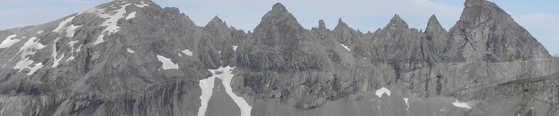
The most impressive mountains of the Swiss Tectonic Arena Sardona are the Tschingelhörner. To go there I suggest you travel to Elm, a small picturesque village in the Glarus region. The village is easily reached by car. Otherwise take a bus from Glarus (the city) as there is no train. In Elm you will find a small funicular that brings you close to the mountains. To get a closer look the only way is to hike. There are (quiet expensive) 1 to 2 days guided tours on weekends that bring you close to the Tschingelhörner. To see the whole area you can hike from Elm to Flims. The trip takes about 6.5 hours and shouldn't be done by inexperienced mountain hikers.
Keep reading 0 comments