North Macedonia
Kokino Archaeo-astronomical Site

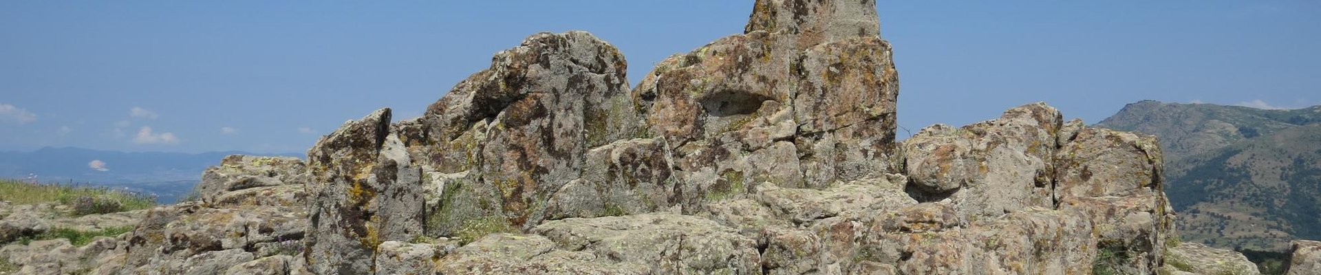
Kokino comprises a holy mountain and ancient observatory from the Bronze Age.
The hill was formed by volcanic rocks, which crack into blocks which have been used by prehistoric dwellers. A platform holds four stone “seats” and nine marker cuttings. Archaeological missions have unearthened fragments of ceramic vessels, hinting on a settlement.
Site Info
Official Information
- Full Name
- Archaeo-astronomical Site Kokino (ID: 5413)
- Country
- North Macedonia
- Status
-
On tentative list 2009
Site history
History of Kokino Archaeo-astronomical Site
- 2012: Requested by State Party to not be examined
- .
- 2011: Incomplete - not examined
- .
- 2009: Added to Tentative List
- Added to tentative list
- Type
- Cultural
- Criteria
Links
- UNESCO
- whc.unesco.org
- Related
-
- academia.edu — Kokino: Archaeological Site and Megalithic Observatory
All Links
UNESCO.org
- whc.unesco.org — whc.unesco.org
Related Resources
- academia.edu — Kokino: Archaeological Site and Megalithic Observatory
Community Information
- Community Category
- Archaeological site: Prehistoric
Travel Information
Recent Connections
News
No news.
Community Reviews
Show full reviews
The Archaeo-astronomical Site Kokino is a Bronze age site in the north-east of the Republic of Macedonia, not far from the border with Serbia. It was rediscovered as recently as 2001 by local archeologist Jovica Stankovski. There’s a lot of overenthusiastic misinformation about the site on the web, consisting of often repeated statements such that it is already a WHS or that it gained a 4th place among astronomical sites by NASA research. For now it is on Macedonia’s Tentative List, being put forward as an ancient observatory and holy mountain. Though it may come across as an obscure site, it is fairly well-known within the country's tourist industry.
I visited Kokino on the penultimate day of my short Balkan Tour of 2015. There’s no public transport going to the site, so I hired a car with driver from travel-macedonia who did the 3 hour round-trip including an hour's wait for a reasonable 40 EUR. The road to Kokino is fully signposted from the turnoff at the Alexander the Macedonian motorway (the country's other main motorway by the way is named after the 2nd best known Macedonian: Mother Teresa!).
The archeological site of Kokino is located at 1013 meters altitude, so when we got closer I searched diligently among the hills in the area in the hope of spotting the site from afar. Without success. After an hour’s drive we suddenly arrived at the "parking" of Kokino. Could this be it? I then noticed a rock protruding above the trees, …
Keep reading 0 comments
Though it is called in the touristic brochures "The Stonehenge of the Balkans", Kokino is definitely far less spectacular. But if you happen to visit Macedonia, or on the way form Central Europe to Greece - as we did - it is an easy and pleasant detour. There are quite a few publication that describe how was it built (or used), and place Kokino among the paleo-astronomical observatories of the world. I am not an expert ob it, so I rather omit theis part. if you are interested, you can read it here, or here. Anyway, it is quite useful, if you make a reasearch before, and print out one of these articles as on the site you will find no clue what is what, and what should you find, or seek. So, as for the scientific side you can be prepared, but if you would like to know the practiclaities, you jump in one of the black holes of the net. Event on the site that looks like an official site of the place, if you open the "How to get there" section you get a detailed list of the airlines that serve Skopje, but nothing closer. Other sites it is write, that it is "near Staro nagorichane", without any exact defitnition of being "near". it is not clear either how steep is the slope leading to the observatory, whether it can be done without special hiking experteese. So here it is:
If you do not have your own …
Keep reading 0 commentsJarek Pokrzywnicki
Kokino Archaeo-astronomical Site
Kokino Archaeo-astronomical Site (On tentative list)

Visited in August 2011. Very difficult to get without your own car. The site is located quite far from civilization. I took the road from Prohor Pcinski (Serbia) to Kumanovo (Macedonia), around 7 km from the border in the village of Dragomance turn left (there should be a sign). The road is not very wide (althoug asphalted) and goes mostly thoughout uninhabited land (hills). From Dragomance it is around 14 km to the observatory (parking place from which it is arond 500 m on foot).
Frankly speaking it is not clearly visible, there are no standing structures, just rocks formed by nature or it so distroyed that it looks like natural. Anyway the views are amazing (it is placed on the top of the hill). Also be prepared for strong wind there.
Keep reading 0 comments