Belarus, Estonia, Finland, Latvia, Lithuania, Moldova, Norway, Russia, Sweden, Ukraine
Struve Geodetic Arc


The Struve Geodetic Arc is a technological ensemble that played an important role in the development of earth sciences.
This chain of survey triangulations, stretching from Hammerfest in Norway to the Black Sea, was established to measure the exact size and shape of the Earth. It was developed and used by the German-born Russian scientist Friedrich Georg Wilhelm von Struve in the years 1816 to 1855.
Community Perspective: with its 34 remaining stations, spanning 10 countries and over 2,800 km, this has become a real Community Cult Classic, representing the “reductio ad absurdum” of the scheme. To the uninitiated, you may expect to see a slab of concrete with a small concrete fence around it; Ian describes the cult appeal well in his review. Many are located in remote rural areas, often on hilltops. The best among them is the Tartu old observatory, which has an exhibition inside. The ones in Belarus are covered by Jarek and Zoe, the one in Moldavia by History Fangirl, Michael ‘did’ Ukraine, and Els Latvia, while Svein and Solivagant described Norway. Others in the Baltic States, Sweden and Finland have been regularly reviewed as well.
Site Info
Official Information
- Full Name
- Struve Geodetic Arc (ID: 1187)
- Status
-
Inscribed 2005
Site history
History of Struve Geodetic Arc
- 2005: Inscribed
- Inscribed
- Type
- Cultural
- Criteria
- ii
- iv
- vi
Links
- UNESCO
- whc.unesco.org
- Official
-
- norgesverdensarv.no — Norwegian measurement points
- maanmittauslaitos.fi — Finnish sites
- Related
All Links
UNESCO.org
- whc.unesco.org — whc.unesco.org/
Official Website
- norgesverdensarv.no — Norwegian measurement points
- maanmittauslaitos.fi — Finnish sites
Related Resources
Community Information
- Community Category
- Secular structure: Science and Education
Travel Information
Serial Transnational Sites
Red Zone Travel Advisory
Recent Connections
-
Perfect Inscriptions
2005 -
Red Zone Travel Advisory
Ukraine parts fully off-limits -
Full White Nights
Norway
Connections of Struve Geodetic Arc
- Geography
-
-
Lapland
-
Full White Nights
Norway -
Arctic Ocean
-
Arctic
-
Baltic Sea
Svartivara Island (Finland) Mäkipällys and Ponit Z on Hogland Island (Russia). All three on island in the Baltic See.
-
- Trivia
-
-
Built or owned by Germans
Von Struve was a Baltic German, born at Altona (Hamburg), Germany -
Repainted in a different colour
Tartu Observatory in Estonia: from bright yellow to white -
Furthest distance apart
Fuglenaes (Norway) and Staro-Nekrassowka (Ukraine) are approx 2830kms/1758 miles apart
-
- History
-
-
Been part of independent Finland (de facto)
Mäki-Päälys, Hogland Z: The island of Gogland or Suursaari in Finnish, Högland in Swedish, was a part of Finland until 1939 when Soviet Union occupied it. Finnish army took it back in 1941 but Soviet Union occupied it definitively in 1942.
-
- World Heritage Process
-
-
First inscriptions
Moldova 2005 (with many other countries) -
Serial Transnational Sites
10 countries (Ukraine Sweden Russia Norway Lithuania Latvia Finland Belarus Estonia) -
Perfect Inscriptions
2005 -
Transboundary only
Moldova
-
- Constructions
-
-
Obelisk
STARO-NEKRASSOWKA Stara Nekrasivka component (and the one at Beresnäki is similar, but not narrow tapering from its base)
-
- Timeline
-
-
Built in the 19th Century
the surveys were made between 1816-55
-
- WHS Hotspots
- Science and Technology
-
-
Astronomy and Astrology
Tartu Observatory -
Mathematical Concepts
Triangulation. Triangulation is the process of determining the location of a point by forming triangles to it from known points, especifically by measuring the angles of the formed triangle. Struve used this approach to measure the meridian and oblateness of the earth by measuring the angles formed of the geodetic points.See www2.mae.ufl.edu
-
Scientific Developments
Determination of Earth's size/shape
-
- Visiting conditions
-
-
Free entrance
-
Red Zone Travel Advisory
Ukraine parts fully off-limits
-
- WHS Names
-
-
Named after individual people
German-born Russian scientist Friedrich Georg Wilhelm von Struve
-
News
No news.
Recent Visitors
Visitors of Struve Geodetic Arc
- AC
- Adrian Turtschi
- alex
- Alexander Barabanov
- Alexander Lehmann
- Alex Baranda
- Ali Zingstra
- A. Mehmet Haksever
- Ammon Watkins
- Ana Lozano
- Anne
- Argo
- Ask Gudmundsen
- Astraftis
- Atila Ege
- BaziFettehenne
- Bill Maurmann
- Bin
- Birgitte Sørensen
- BobSmithseestheworld
- Bram de Bruin
- Carlos Sotelo
- CeeMon
- Cezar Grozavu
- Cheryl
- ChrisDorn
- Christer Sundberg
- Christian Wagner
- Christoph
- Christravelblog
- Claire Bradshaw
- Clyde
- Cody Ayers
- Colossus
- Coppi
- Csaba Nováczky
- ctravel
- CugelVance
- cwthong
- Cyberczar
- Daniel Chazad
- Dan Pettigrew
- David Berlanda
- DavidS
- debatecoach
- del
- Dimitar Krastev
- Dolemite92
- DouglasR
- Elaine McArdle
- Elia Vettorato
- Ellen Nielsen
- Els Slots
- Erik G
- Erik Jelinek
- Errol Neo
- Eva Kisgyorgy
- Evgenii
- Farinelli
- Federico P.
- Feldhase
- Felicité
- Femke Roos
- Filippo Ubaldi
- Frédéric M
- FS
- Gary Arndt
- g.emma_bae
- George Gdanski
- GeorgeIng61
- Gernot
- Grzegorz Andruszkiewicz
- Hadrianus
- HaraldOest
- Harald T.
- Harry Mitsidis
- Hdhuntphotography
- henrik_hannfors
- hotpickle
- Hubert
- Iain Jackson
- Ian Cade
- Ingemar Eriksson
- Ingrid
- Ivan Rucek
- Jacob Choi
- Jakob F.
- Jakubmarin
- janis
- Jan Korpeg
- Janos
- Jan-Willem
- Jarek Pokrzywnicki
- Jasam
- Jay T
- Jean Lecaillon
- Jens
- Jesse S 2010
- Jezza
- JobStopar
- Joel on the Road
- Jonas Hagung
- Jonas Kremer
- Jonas Martinsson
- jonathanfr
- Jon Eshuijs
- jonstst
- Joyce van Soest
- Juha Sjoeblom
- KarenBMoore
- Karito Vies
- Kbecq
- Ken DJ
- Klara Woodson
- Klaus Freisinger
- Knut
- Kurt Lauer
- Lara Adler
- Leonie Geurts
- lichia
- Loic Pedras
- Luboang
- Lucio
- Ludvan
- Luis Filipe Gaspar
- Maciej Gil
- Maciej Gowin
- Maja
- Małgosia Łupicka
- marcel staron
- MarcoB_0
- Martin
- Martina Rúčková
- Mateusz
- Mathijs
- MatusBeber
- Max
- MaxHeAnouBen
- MaYumin
- MH
- Michaela0705
- Michael Ayers
- Michelle2323
- Mikko
- Mikko Syrjä
- Milan Jirasek
- Miloš Tašković
- MMM
- MoPython
- nan
- Nihal Ege
- Olli-Pekka Turunen
- PabloNorte
- Patrik
- Patrik_globe
- Paul Schofield
- Peltzi
- petar
- PeterH
- Peter Lööv
- Petteri
- Philipp Leu
- Philipp Peterer
- Piotr Wasil
- Rafał Kałczuga
- Rahelka
- Ralf Regele
- Randi Thomsen
- Reiseblitz
- Remigiusz
- Remski
- Reza
- Riccardo Quaranta
- Roger Enarsson
- Roger Ourset
- Roman Bruehwiler
- Roman Raab
- Rudegirl
- Schnitzel
- Sebasfhb
- Sergio Arjona
- Shandos Cleaver
- Slavi
- Solivagant
- Ssong.x
- Stanislaw Warwas
- Stijn
- Svein Elias
- Szucs Tamas
- Tamara Ratz
- Taotao Chen
- Tarquinio_Superbo
- Tatiana Nikulnikova
- Tevity
- TheTravelingRanger
- Thomas Buechler
- Thomas Harold Watson
- Thomas van der Walt
- Tinamu
- Tom Flaten
- Tony H.
- triath
- Tsunami
- usagi1974
- WalGra
- Walter
- Wimmy
- Wojciech Fedoruk
- Wo_ko
- wolfboy
- YaroMir
- Yevhen Ivanovych
- Zach
- zfish
- Zoë Sheng
Community Reviews
Show full reviews
Visiting your first component of the Struve Geodetic Arc is a rite of passage for a WH Traveller: it marks the moment that you have gone from a tourist enjoying the sights of the world into a nerd obsessed with the quirky details of lists. I have visited components of the Arc in several countries over the years. But I had not yet been to the place where Struve started it all and where some of the more interesting remains lie: Estonia.
Born in Altona (near Hamburg, but at the time under Danish rule) in 1793, Struve emigrated with his parents to the Russian Empire. More specifically, to Livonia, an area that was later divided between Estonia and Latvia. He studied at the University of Dorpat (now Tartu) and became a Professor of Mathematics and Astronomy there. It was during this period that he started his geodetic surveys in a small area around Tartu. Later on, even becoming the director of the Tartu Observatory, he obtained funds to extend his surveys further north and south and to further develop his equipment. The full measurements of ‘his’ Arc were only completed in the 1850s, requiring lots of international scientific cooperation and funding. The Nomination Dossier especially highlights the “considerable amount of international labour under various climatic, topographic and geographic circumstances”.
What Struve and his colleagues tried to do was to determine the size and shape of the earth by way of triangulation. How they did this precisely is explained in Appendix …
Keep reading 3 comments
In our extensive coverage of Struve sites, the Latvian locations so far have been underexposed. On my recent road trip across Latvia I used the quirky city of Jekabpils for an overnight stop – it is large enough to have amenities such as a decent hotel, ánd it has a Struve location in the city center.
The marker is located in a small park, renamed “Struve Park” in 1992 after it had been known as Pushkin Park during Soviet times. The ‘shrine’ looks well cared for. From the information panel (upper photo) we learn that this site was measured by Struve and his team in May-June 1826 and that the process to determine the correct astronomical point took 3 weeks.
Struve put a brick post here with an iron pole in the centre, and the surrounding area was fenced off. In 1931 a 42m high wooden tower was built above the Struve point, which subsequently was used by Latvian scientists and students. Both historic markers have since disappeared; nowadays there are three markers next to each other: the small obelisk with a copper WHS plaque that we also know from other locations, a granite stone dating from 1931 that was put on top of the damaged original one by a local science teacher, and an artist’s sculpture from 2008 symbolizing a triangulation tower.
And the Struve excitement wasn't over yet: on my way to a supermarket at the other end of Jekabpils city center, my eye fell …
Keep reading 0 comments
January 2023 this is possibly one of the least exciting WHS to visit. Anyway WHS lunatics want to tick it off the bucket list. On our Baltic Trip 2017 I completely blanked out the two spots around Vilnius. Years later I was still mad about. Now, on a spontaneous trip to Tallinn and surrounding my travel buddy asked me, whether visiting Tartu would be within our itinerary.
Of course! I am happy to visit! So after daytrips to Helsinki and Laheema NP in our 4th travel day we took an early train to Tartu through wonderful snowy Landscape and arrived approx. 2 hours later.
Tartu will be European Cultural Capital in 2024, so there is a bit more to visit than just the observatory. On Sundays it's closed unfortunately, but I guess you get to see more than at some other measuring points. The view above Tartu is also lovely.
Tartus old City alone is worth a daytrip from Tallin. We enjoyed this sleepy and charming town.
Keep reading 0 comments
Visit in July 2020
The Pandemic of 2020 completely demolished any hopes I had of ever attempting to visit any of the European Pile Dwellings locations, and it did its best to similarly affect that other collection of unobtrusive artifacts in obscure, out-of-the-way locations, the Struve Geodetic Arc. However, in the latter case I refused to be defeated. I originally had planned to see one or two of the locations in Lithuania, as many others have already done, but since that became problematic I needed to find another alternative. As luck would have it, the cluster of triangulation points in central-western Ukraine were not far from where I expected to be in late July, so I salvaged the opportunity to claim my Struve site visit by heading in that direction. Since it doesn’t seem that any of these locations have been seen by others here, I will add another Site review.
There are three points surrounding the city of Khmelnytski, one to the south, another to the southwest, and the third to the northwest. Whoever added the points to the Google map here on this site put the makers in the exact spot where the Struve points are, so a big thank you is due to whomever worked on that (you know who you are.) The point to the south of the city appears in Satellite View to be in the middle of a crop field at the moment, so I decided not to try for that one. …
Keep reading 0 comments
WHS hunting is interesting and fun. Some are more interesting some er more fun. The interesting part of the Struve geodetic arc is the story about Friedrich Georg Wilhelm von Struve and his work. The fun is the hunting - finding obscure places – like those with a Struve “tag” on it.
We have visited 14 of these sub-sites in 5 countries (of the total of 34 in 10 countries), mostly by car.
Our first encounter was in Finland 2010 (just a small wooden pole in the woods). In 2019 we visited all five in Belarus (all stone monuments - and fairly easy to locate) and this year we completed the four in our own country, Norway. Few of these Norwegian sites are very visual, but it is fun finding a way to reach them.
Struve Norway
Norway’s got the northernmost Struve sites thus making it a bit “out of the way” for most travellers, but for us WHS hunters we make our business “everywhere” and a visit to for instance the site of Alta with its rock art is mandatory. Not far from the centre of Alta situates one of the easiest one, and our first – in 2016.
Lille Raipas
A little less the 2 km east of the World Heritage Center – Alta museum turn right and follow the E45 for 3 ½ km. Then turn left and cross the river and follow Raipasvegen (the Raipas road) for another 3 km. …
Keep reading 0 comments
"Struve Stories" (continued) - 1187-001 FUGLENAES (Norway)
John Booth reviewed this location back in 2010 but, following our visit in Dec 2018, there are a few more aspects about it, and the Struve Arc as a whole, which I think are worth recording. This is the very furthest north location of the Arc and has been allocated reference number "001" by UNESCO. It certainly possesses a rather fine memorial (photo) and is, presumably, where the whole survey started?
Well not really. The idea that Struve and his team went to a furthest point and “triangulated” their way South to the other end isn’t how it happened. The process leading to the inscribed continuously surveyed arc took around 40 years and didn’t even start with that objective in mind. 2 "Russians" (the former was born in Altona, then under Danish sovereignty, of a German speaking family which emigrated to Russia and he is usually characterised as "German Russian whilst the latter was born in present day Estonia!) - the Astronomer Prof Struve (1816) and Lt Gen C.F Tenner of the Russian army (1817) had started in different parts of W Russia for different reasons – the former in Livonia for largely scientific ones and the latter in Lithuania for military mapping purposes (this was soon after the Napoleonic wars and the military and Tsar Alexander I recognised the need for better maps of his country). By 1828 they started to work together and, around 1831, Tsar Nicholas I agreed to give …
Keep reading 0 comments
I had finally made it. After always ignoring this WHS due to the distances involved in getting to any or the lack of interest to actually go out of the way to see a monument I would drive along the road in Belarus to see a Cyrillic UNESCO World Heritage sign on the side: Leskovichi Ivanovo. I had obviously added this to my list of places to visit knowing it was so easy to attach to the itinerary. There is even a bus stop here in the middle of nowhere!! You don't have to go far to see the marker, 5 meters off the road. Behind the Struve monument is an old device used for measuring plus a sign post to explain the arc, it's importance and history in English as well. Overall I was satisfied and spent a good 15 minutes reading, taking pictures and doing a quick Wikipedia read plus the sun was out in early April.
I suppose I don't recommend visiting unless you are into science or history, or both, but this was so convenient I couldn't dismiss it.
Keep reading 0 comments
This was the most satisfying UNESCO site to date, which seems crazy to me.
Getting there from Chisinau was pretty easy. A driver took me (about 3hrs each way). Cost about 50 euros total for the taxi. We also stopped at the Rudy Monastery nearby.
The monument is in the middle of an Apple Orchard. No one at my hotel in Chisinau, my taxi driver, or anyone at the monastery knew about the Struve point or where it was. However, a local farmer knew how to get to the point. There's actually a sign off the highway, but it's not clearly visible. Using the gps points didn't work.
Like other Struve points, there's not much to see. However, I felt euphoric afterwards.
Read more about my Unesco World Heritage travels on my website.
Keep reading 0 comments
After seeing several Struve monuments or geodetic points in Norway, Lithuania and Latvia (there are several points which have not been inscribed!), I made an effort to get a better understanding of this WHS by visiting the old Tartu Observatory in Estonia in September 2016. Some pointers to keep in mind if you intend to visit: opening hours are Tuesday to Sunday 10:00 to 18:00 and if your very keen and have enough time you can also try your luck by booking at least 3 days in advance for a night visit including an observation from the old observatory’s main telescope, a Carl Zeiss Refractor from 1911. The old observatory is situated in the middle of Tartu on a hill full of trees. This means you'll most likely not be able to see it while driving around in circles to find a parking spot. There are stairs leading up to the observatory from different points around the hill. Make sure to bring a mosquito repellent in summer, you won't regret it. There is a Struve Monument just in front of the old observatory and a metal sheet/Unesco plaque just next to the entrance. Once you enter the old observatory, make sure to look where you're standing while paying the entrance ticket. Most probably you'll be standing on the observatory's Struve Geodetic point, the first point of the geodetic arc (centre of my photo collage). Next to the point, there is an information board on Struve and a huge one storey …
Keep reading 0 comments
With the Struve Arc being “in the news” on this site because of the 2016 “WHS Travellers Meeting” visit there, it seems a good time to add a review of another location which, as far as I can see, hasn’t previously been reviewed here - UNESCO Ref 1187-013 Porlom II in Finland which was visited by us in Aug 2016.
The site is very conveniently situated about half way between Helsinki and the WHS of Verla Board Mill - a visit to it by car from Helsinki will still get you to Verla in time for lunch. At around 115kms out of Helsinki, turn north off route 6 along 1771 (The WHS is not signed at this turn off). After 10kms you will reach the village of Porlammi. There, take 1751 north for a few kms and you will see a sign to the WHS pointing right (north) along a dirt road which leads to a beach (In Finnish = “Uimaranta”) on the nearby Lake Pyhäjärvi (apparently, there are 39 lakes in Finland named “Pyhäjärvi” which means “Holy Lake” so, if you are using map software, be sure you get the right one!). There are no more signs along a road which has a fair number of junctions - you just have to navigate on dead reckoning north towards the lake following the most “used” tracks!
If you reach the shore you have gone about 300 metres too far. Set back from the road in light undergrowth to the left …
Keep reading 0 comments
Four years since my last visit.
Three weeks of internet research.
A three hour flight.
685 km of driving.
One aborted attempt to visit from a more logical place on the map.
One surprise sign post pointing us in the right direction.
6 km of off road rallying.
One creative bit of parking to accommodate another car heading in the other direction down the country lane.
600m of scrabbling over rocks through the forest.
7-8 insect bites.
And this is a photo of our reward.....
Was it worth it?
Mr Cade said yes!
Mrs Cade wasn't quite as enthusiastic.
Keep reading 0 comments
Belarus has 5 sites related to Struve. 3 of them are located quite close to Ivanava (Polish name Janów Poleski) in the southern part of Belarus.
Easily to see if you have your own transport. On the main road Brest - Pinsk there are no signs of the site. From Janów take road H472 to Motol (Motal). From there turn right to Osownica (Asaunica). Struve point is located on the top of the hill (south-eastern part of the village).
Next point is in the forest close to Szczekuck (Szczakock) - road Motol - Janów, there is a sign of Struve, the point located some 500 meters from the road.
The last point is completely unmarked located on the hill (in the middle of corn fields) close to the village of Laskawiczy (no road nor path to get there).
All sites looked to be well maintained and recently prepared for visiting
Keep reading 0 comments
Last autumn I found some more sites within the Baltic States:
Simuna and Voivere, Estonia - an obelisk in Simuna and an underground stone at Voivere, both sites accessible by bus from Rakvere.
Tartu, Estonia - the observatory, on a hill overlooking the town, is closed on Mondays and Tuesdays. There is a memorial to Struve nearby. The site is accessible from Tallinn by bus and train.
Jekabpils, Latvia - the site is located in Struve Park on Struve Street, close to the Daugava River. The town is accessible by bus from Riga.
Keep reading 0 comments
I am happy to finally be able to tick off this weird WHS, and present to you a trip report to another one of the measure points. I choose “Oravivuori”, located on the top of a hill some 30km south of Jyväskylä in Central Finland. A GPS or car navigation will steer you close using the provided coordinates. The site is also signposted well from the main road between Tampere and Jyväskylä, and you should follow these signs to reach the improvised parking lot at the foot of the hill. It’s better to turn off the car navigation for the final stretch, as at least my TomTom wanted to take me on a different (unpaved) route.
The site lies 8 km from the main highway. The road is mostly half-paved and unpaved for the last km. Access is not maintained in winter, and I also wouldn’t advise a visit during or just after heavy rains. From the car park, a path leads uphill for one km to the top, where the measuring point is and also an observation tower. “One km” doesn’t sound far, but it is a steep climb on a narrow path. There are information boards at the start and along the way, as well as wooden benches to sit on every 250m. It surprised me how well-looked after it all is, as it isn’t a site where the casual tourist would show up.
There’s an open area at the top of the hill, just enough …
Keep reading 0 comments
If you want to choose one point to visit Struve Geodetic Arc the best place is probably the Tartu old observatory. The observatory is located on a hill next to the town centre. Inside of a observatory there was small exhibition about astronomy and 2 very helpful ladies who told about the history of observatory and the geodetic arc. There was big map of the Struve arc and some brochures and sign saying it's world heritage site.
Otherwise Tartu is very lovely town, worth of day trip from Tallinn for example. There's buses (and slow train) going all the time between the cities.
I have also visited the Aavasaksa point of arc in Finnish Lapland long time ago. It's right next to the road between Tornio and Kilpisjärvi and good place to stop on your way to north and see the beautiful views to Tornio River valley.
Keep reading 0 comments
Sturve Geodetic Arc is a very stange multi-location site.
Each location is quite small, some corresponding to a 100 meter diametre circle centered on a traingulation point. Those points may consist just of a small mark on a stone.
I visited 3 of those sites in June 2009.
The first went to Tornea church in Finland. A simple church typical of that area, from which tower Sturve made a triangulation point. Easy to find in an otherwise unremarkable Finnish border town.
The second point I visited was Peera-Vaara in Sweden. It is a point atop a flat hill, which is supposed to be the highest point in the area. It is difficult to find. It is closed to the village of Hedenäset. The dirt road going to the point is not marked, and I was lucky to have printed the map included in the nomination file to find my way. Follow a dirt road going on the left from road 398 from the village. After 10 minutes turn right uphill, and after a few minutes, there is a small parking spot (place for 2 cars only). From there, 10 minutes walk on a wooded path.
You then reach a mark on a stone with a wooden sign above it. It is in the middle of the forest (hence no view). This place is only for the World Heritage collectors, even if the forest walk is quite nice.
The third point is luckily much easier to find ; Avasaksa is a …
Keep reading 0 comments
So far I have only visited several site on the arc in Scandinavia, although like Ian I fear there may be more in the future.
I reached the Alatornio Church by travelling from Kemi station by bus to Tornio, a town located on an island in the Tornio River. The church with its distinctive clock tower is on another island further south and facing the Swedish town of Haparanda on the opposite bank. The short way to the church is by crossing a footbridge back to the Finnish shore, going south, then crossing the railway bridge linking Sweden and Finland, with its dual gauge tracks. This brought me to the cemetery at the back of the church.
On the bus journey through Lapland from Rovaniemi to Alta I stopped in Enontekio and Kautokino, but didn't locate the Struve markers in either place or in Alta.
But I did visit the Struve obelisk on the Fuglenaes Peninsular near Hammerfest. Although it is in a fairly industrial part of town my only companions were a herd of reindeer grazing on the newly planted lawn. Hammerfest, on an island connected by bridge and tunnel to the Norwegian mainland, is the end of the line for a bus service from Alta. I was amazed to find here at latitude 70 deg N that there is a city, factories, grass and animals. I had previously been at latitude 70 deg S (Antarctic Peninsular) where there are only rocks, ice and penguins.
Keep reading 0 comments
At some stage this interest in World Heritage Sites turned from an awareness of major tourist sites into a full blown obsession. This was perhaps best illustrated by the fact I found myself alone in a field a few km off of the Vilnius- Minsk highway on a particularly chilly Saturday morning.
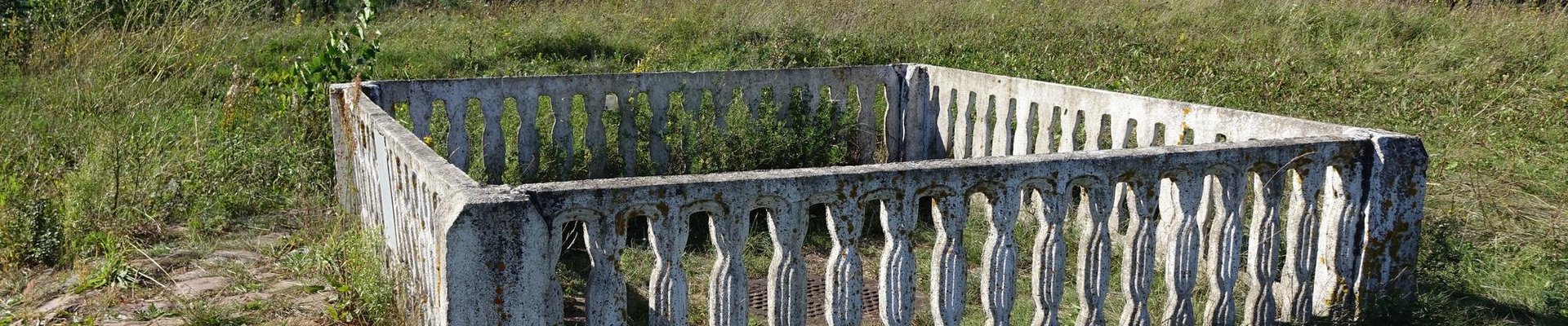
The measuring post I visited was at Beresnäki about 18km from Vilnius. It is essentially a slab of concrete with a small concrete fence around it. Next to this is a small obelisk marking its inscription on the World Heritage List. There was also an information board. Aside from that there was nothing else in the field. I walked about 3km to get to the field from a local bus stop. There were a few houses on this route and two locals stopped me to ask where I was going, unfortunately I hadn’t learnt “I’m going to look at a geodetic measuring post in a field up ahead” in Lithuania by this point, and probably never will. Despite being so close to the capital this area did feel particularly rural. You won’t be surprised to find out that mine were the only set of footprints in the snow that led up to the site.
Altogether it took me about 1h45mins to visit this site including about 5 minutes at the site taking photos and doing a few laps.
I’m now left in a quandary about when to count the Struve Geodetic Arc as a visited site. I have …
Keep reading 0 comments
I've been to four sites(Alatornio kirko,Aavasaksa,Dorpat observatory and JACOBSTADT point).
It's scientific interest,but almost sites are difficult to get.
Thus the more these are difficult to get,the more emotional when found.Struve Geodetic Arc is so.
When I've been to the Dorpat Observatory in Tartu,Estonia,it isn't open for public.
But the workers to restore the architecture allowed me to see inside and climb the ladder up to the top so that I could see over the view of city of Tartu.
Keep reading 0 comments