Sweden
Southern Öland


The Agricultural Landscape of Southern Öland is a site that has been in agricultural use since prehistory.
One of its main features is the Stora Alvaret, a so-called "limestone pavement", a biological environment based on a limestone plain with thin or no soil. Local farmers have adapted to the circumstances and use it for grazing their livestock. Among the archeological sites are Alby, where excavations have revealed vestiges of wooden huts around a prehistoric lagoon, ringforts at Eketorp, and various Viking settlements.
Community Perspective: Reachable by a bridge from Kalmar on the mainland, Southern Öland also has fine natural features (such as Ottenby Nature Reserve and the savannah-like grass of Stora Alvaret). The overall appearance is a bit similar to the Netherlands with several wooden mills on a flat landscape.
Site Info
Official Information
- Full Name
- The Agricultural Landscape of Southern Öland (ID: 968)
- Country
- Sweden
- Status
-
Inscribed 2000
Site history
History of Southern Öland
- 2000: Inscribed
- Inscribed
- Type
- Cultural
- Criteria
- iv
- v
Links
- UNESCO
- whc.unesco.org
- Official
-
- sodraoland.com — Southern Öland World Heritage
All Links
UNESCO.org
- whc.unesco.org — whc.unesco.org/
Official Website
- sodraoland.com — Southern Öland World Heritage
Travel Guides
- en.oland.se — Öland's official visitor guide
Community Information
- Community Category
- Cultural Landscape: Continuing
Travel Information
Recent Connections
-
Cultural WHS set within an IUCN recognised protected area
Ottenby, IUCN Category Ib (Nature Reser…
-
Hunting Lodge or Castle
Ottenby Royal Estate (Ottenby Kungsgård…
-
Perfect Inscriptions
2000
Connections of Southern Öland
- Individual People
-
-
Carl Linnaeus
Linnaeus was the first visitor to record the distinctive features of Öland, in the description of his Öland journey in 1741 (nom file)
-
- Geography
-
-
Baltic Sea
-
Isostatic Rebound
The entire island only rose from the Baltic 10000 years ago. The plateau of Stora Alvaret contains several 7000 year old iron age settlements which today are set well back from the coastline - remains show the early inhabitants to have been involved in fishing -
Straits
Kalmarsund -
Notable lakes
Möckelmossen "West of Möckelmossen there are three groups of house foundations which were excavated during the 1970s. Finds have included bone fragments of cattle, horse, sheep/goat and pig." - nomination fileSee sv.wikipedia.org
-
- History
-
-
Bronze Age
"On Stora alvaret there is a series of large Bronze Age burial cairns" -
Palaeolithic and Mesolithic
-
Neolithic age
"Passage graves on Västra Landborgen provide evidence for permanent settlement in the Neolithic period." (AB ev) -
Iron Age
"Large burial grounds from the Iron Age testify to a rich and important pre-history. The present agricultural community has a continuity which partly extends as far back as the Iron Age." - nomination file
-
- Ecology
-
-
Bird Migrations
Southern Oland's Ottenby Bird Observatory (migrating birds)
-
- Architecture
-
-
Dry Stone Construction
Eketorp Castle -
Vernacular architecture
-
- World Heritage Process
-
-
Perfect Inscriptions
2000
-
- Religion and Belief
-
-
Fortified religious buildings
Hulterstad, Remso
-
- Human Activity
-
-
Irrigation and drainage
Alby -
Viking settlements
"Later, around the years 800 to 1000 several Viking settlements appeared in the periphery." (wiki) -
Hunting Lodge or Castle
Ottenby Royal Estate (Ottenby Kungsgård) is a historic Swedish royal domain on the southern tip of Öland island, known for its royal hunting grounds
-
Royal Hunting Grounds
royal hunting park until 1801 (nom file) -
Ongoing Archaeological digs
Sandy Borg (2010 to present) Dept. of Museum Archaeology/Kalmar County Museum, The Linnéaus University and Stockholm University. -
Writing systems
Runic Script "Prominent among the 20 or more runestones of Southern Öland is the Karlevi stone, with a unique skalde poem in the dróttkvaett verse foot, commemorating a man called “Sibbe the wise”. - nomination fileSee en.wikipedia.org
-
- Constructions
-
-
Cemeteries
Nordic Bronze Age grave field of GettlingeSee en.wikipedia.org
-
Windmills
"Farmsteads and other buildings are constructed of materials from Öland, with the “Geatish homestead” and windmills forming distinctive features" (AB ev) -
Lighthouses
Lange Jan Lighthouse located at the most southern point of Oland
-
- WHS on Other Lists
-
-
Ramsar Wetlands
Ottenby 1974, Öland Eastern Coastal Areas 1974See www.ramsar.org
-
Cultural WHS set within an IUCN recognised protected area
Ottenby, IUCN Category Ib (Nature Reserve)
-
Natura 2000
- Large portions of Southern Öland were added after inscription. "In the south of Öland about 13,900 hectares have been proposed for inclusion in Natura 2000. 1,806 hectares of these are designated as “Bird conservation areas” while 12,477 hectares are proposed as “Natural habitat protection area”. Fifty-five of the species included in the annexes to the Habitats and Birds Directive are represented in the south of Öland." - nomination file
-
- Timeline
-
-
Built in the 7th millennium BC
About Alby: "The village prehistory dates to the early Stone Age when settlers from the mainland migrated across the ice bridge connecting the island via the Kalmar Strait about 6000 to 7000 BC" (wiki) and "The first human beings to come to the island of Öland were the hunter-gatherers who arrived 8000 years ago." (AB ev)
-
- Science and Technology
- Literature & Film
-
-
Works by Nobel Prize winning authors
Selma Lagerlof (1909) - The Wonderful Adventures of Nils -
Poetic Quotations
- "Prominent among the 20 or more runestones of Southern Öland is the Karlevi stone, with a unique skalde poem in the dróttkvaett verse foot, commemorating a man called “Sibbe the wise”. - nomination fileSee en.wikipedia.org
-
News
No news.
Recent Visitors
Visitors of Southern Öland
- Alexander Barabanov
- Alexander Lehmann
- Argo
- Ask Gudmundsen
- Atila Ege
- Axel Hansson
- BaziFettehenne
- BeyondMonkey
- Bill Maurmann
- Bin
- Birgitte Sørensen
- Bodil Ankerly
- Cezar Grozavu
- Cheryl
- Christer Sundberg
- Claire Bradshaw
- Clyde
- Csaba Nováczky
- CynthiaW
- Daniel Chazad
- Daniel Gabi
- David Berlanda
- Delphine Delaunay
- Dimitar Krastev
- Dirk-pieter
- Ellen Nielsen
- Els Slots
- Erik Jelinek
- Errol Neo
- Eva Kisgyorgy
- Farinelli
- Femke Roos
- Frederik Dawson
- George Gdanski
- GeorgeIng61
- Hadrianus
- Harry Mitsidis
- Hdwilsonau
- hegeline@icloud.com
- henrik_hannfors
- Iain Jackson
- Ingemar Eriksson
- Ivan Rucek
- Jaakkotoivanen
- Jacob Choi
- Jana and Matt
- Jan Korpeg
- Janos
- Jarek Pokrzywnicki
- Joel on the Road
- Johan
- jonas
- Jonas Hagung
- Jonas Kremer
- Jonas Martinsson
- Karito Vies
- Kbecq
- Kim, Soo-youn
- Klaus Freisinger
- Kyle Magnuson
- Laurey
- Lazerway
- Linneaaasaurus
- Luis Filipe Gaspar
- Lukasz Palczewski
- Maciej Gil
- Maciej Gowin
- marcel staron
- Martin
- Martina Rúčková
- MH
- Michael Ayers
- Mikko
- Mikko Syrjä
- Milan Jirasek
- Miloš Tašković
- MMM
- Monica66
- nan
- Nasebaer
- Nihal Ege
- Olli-Pekka Turunen
- Patrik
- PeterH
- Peter Lööv
- Philipp Leu
- Philipp Peterer
- Piotr Wasil
- Potsdamer
- Randi Thomsen
- Roccobot
- Roger Enarsson
- Roger Ourset
- Roman Bruehwiler
- Rudegirl
- Sabrina Liebehentschel
- Schnitzel
- Sergio Arjona
- Shandos Cleaver
- SirLoydd
- Solivagant
- Stanislaw Warwas
- Stefan Loov
- Svein Elias
- Szucs Tamas
- Tarquinio_Superbo
- Tatiana Nikulnikova
- Thomas Buechler
- Thomas van der Walt
- Tom Flaten
- Truls Brekke
- Tsunami
- Walter
- Wojciech Fedoruk
- YaroMir
- Zoë Sheng
Community Reviews
Show full reviews
I had one full week in Öland, so I knew I would have ample time to fully explore and comprehend this somewhat elusive WHS. My ancestors are from two small villages Northeast of Borgholm. Moreover, since this was Midsummer, one of the most important holidays in Sweden, I was fairly busy meeting relatives, celebrating the holiday, visiting family grave sites, and exploring the Northern portion of the Island via my cousins car or bike riding.
Late June gave me nearly 18 hours of daylight, and at 8am I left Borgholm for a truly all-day trip to every key portion of the inscribed area of Southern Öland. This took much research, including reading the vague nomination file, which rarely identifies specific sites and the pictures are hardly visible (captions). Here is a list of key places to help the would be traveller. This list is not exhaustive, there are various other runestone markers, stone fortress ruins, and historic churches that I hope to see during a return visit.
Iron Age landscapes
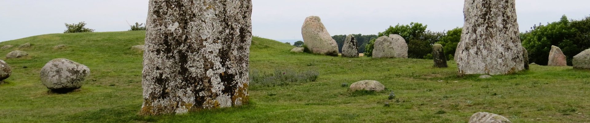
- Gettlinge Grave Field
- Mysinge Grave Field
- Eketorp Fortress (reconstructed)
Viking Age
- Karlevi Runestone (de facto Northern border marker of the core zone)
Middle Ages
- Resmo Church
- 'Geatish'-style farmstead in Nasby (Radby)
- Line Villages (Southeastern Öland, Nasby to Gårdby)
- Gammalsby Coastlands (Gammalsbyören)
Royal Hunting Reserve (17th Century)
- King Karl X Gustav's Wall (1653)
- Ottenbylund (hunting reserve)
Industrial Age (18-19th Century)
- Alum Works in Degerhamn (Södra Bruket)
- Långe Jan Lighthouse & Ottenby Bird Observatory
Stora Alvaret (Hike/Walk)
- Möckelmossen
Ramsar Sites
- Ölands …

I visited this WHS in July 2016. I drove here from Vaxjo and after crossing the bridge to the island I stopped on the right to pick up some information brochures and maps. It was really a wise thing to do as the interesting sites are not visible on most GPS navigators and are only marked with a brown sign along the road. However, any resting spot, hotel or windmill might have the same brown sign so without a map you might miss worthwhile stops. Hopefully, now that I've been there I can give some pointers on what in my opinion is worth visiting and the names you should be on the lookout for. I inputted Ottenby Nature Reserve on my GPS and drove along the outermost road with the flat Stora Alvaret on one side (a limestone habitat of several rare and endangered species) and the Baltic Sea on the other. The Stora Alvaret landscape is nowadays an agricultural landscape with several mounds and burial stones here and there. Aesthetically it reminded me a lot of Hvar, Croatia or Terceira in the Azores. Oland is the second largest island in Sweden so expect to drive for an hour or so to get to the southernmost tip but you'll be stopping along the way and walking for quite a bit so plan at least half a day to scratch the surface. I cannot understand why such a site has not been inscribed as a mixed site because it clearly has …
Keep reading 0 comments
I drove to Öland from Karlskrona, which takes about 1.5 hours. The bridge from the mainland to Öland was fairly busy with tourist traffic and lots of caravans and campervans. The north of the island is said to be a popular holiday destination. I had come to the south of the island of course, as that's where the WH lies. The core zone however comprises about 1/3 of the island, so just after leaving the bridge and turning to the right, I started seeing WH signs.
I had no clear plan of what to see and did not know what to expect of it either. "Looks like Holland" is not why I came all the way down here for a Saturday. But already from the beginning, there were lots of cute little windmills by the side of the road. They are much smaller than their Dutch counterparts. 62 have been preserved, though none of them are in use anymore.
Other iconic sights in Öland are the Bronze Age and Iron Age burial sites. Just like the mills, they are conveniently close to the main road southwards down to Ottenby. Every site has a small parking lot and an information panel, most of the time in Swedish, German and English. The most impressive burial site that I visited was the Gettlinge burial ground, which is an example of the "stone ship" burial custom where stone slabs surrounding a grave are laid out in the outline of a ship.
After an hour …
Keep reading 0 comments
When I read guidebook's review on Oland, I was curious with their wordings "haunted beautiful", the words that in my opinion a very strange way to summarize certain place; however, I could not agree more with the wordings they chose after I saw this place. From the historic city of Kalmar, I rented a car and drove to Oland, while most of tourists turned left to the north part of the island for beach and cultural villages; I easily decided to turn right to the opposite direction where the World Heritage Sites located, the agricultural landscape of Southern Oland.
At first the flat landscape of farmland was quite Dutch nostalgic with many windmills, large red farmhouses and light forests, then the landscape changed to green hill with stonewall and many impressive standing stone of Viking tombs against the misty sky that made mystery or maybe spooky aura, a landscape that not so Swedish at all! After the strange farmland area, I was at the Stora Alvaret, a large limestone plain; the area looked very dry compared to other area on the island. The stone plain was full of dry savannah-liked grass with some bush and wildflowers, another odd landscape of this island. I continued to finish my trip at Ottenby which was the most southern spot of this island. The area was the desert landscape of peat, hundreds of mosses covered rock and Baltic Sea that were merged together into some kind of a weirdly bog wetland that …
Keep reading 0 comments
In my 2 weeks in Sweden, this was the most interesting WH site I have come across. The landscape of the Stora Alvaret is unique and fascinating, like nothing I had ever seen before. A barren limestone plateau, it covers the southern half of Öland and combines many historic sites with unique natural features (I think it should be a mixed WH site). Driving or cycling is probably the best way to explore Öland, but public transport is also an option. I took the bus from Kalmar (a great city by the way, with a fantastic castle and a nice old town) across the impressive Öland Bridge to the pretty port of Färjestaden. From there I went to Eketorp, an interesting Iron Age fortification that is today a major tourist attraction. Next I went to the Ottenby Nature Reserve on the southern tip of the island, which features a wide range of habitats for migrating birds - and I also climbed Scandinavia's tallest lighthouse there. I thought this was the most interesting place I saw on Öland. Taking the bus is a bit complicated, because even in summer, they don't run very often, but with a bit of planning, it works out fine, and many interesting landscape features can be admired just as easily from the bus.
Keep reading 0 comments
There are several buses that cross the bridge from Kalmar to Oland. I took a #103 bound for Ottenby, and returned on a #105. Along the way I passed several ancient earthworks, stone walls and circles and a number of old windmills while crossing the flat arable landscape. At Eketorp I visited the castle and then the Ottenby Nature Reserve near the lighthouse.
I stopped off at Gronhogen for lunch and to inspect a windmill and some walls and earthworks near the harbour, but there was nothing by way of explanation of what they represented.
Keep reading 0 comments
Although the words (I mean the description of the monument) are there, they do not say anything. You should see the immense alvar yourselves - incredibly flat limestone plateau of Southern Oland. I hope, they included also the fairytale Midlandsskogen (Middle Earth Forest) with the misterious Ismantorps borg - strange, abandoned limestone city with seven gates. The city is located in middle of this huge beach and oak forest.
Keep reading 0 comments