Ecuador
Sangay National Park

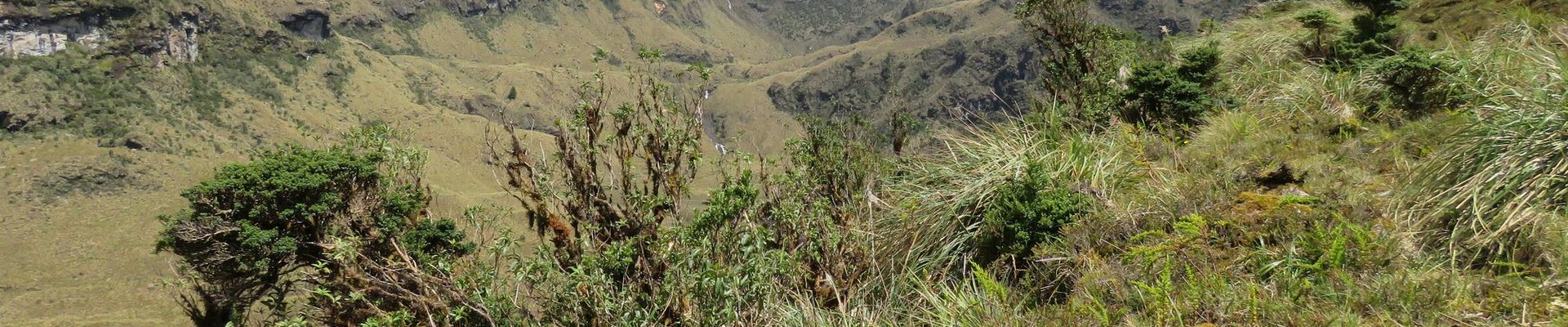
Sangay National Park contains two active volcanoes (Tungurahua and Sangay) and ecosystems ranging from tropical rainforests to glaciers.
Volcanic ash has created fertile soil, which has led to over 3,000 species of flowering plants in the park. It also contains one of the largest areas of páramo (alpine tundra) occurring in Ecuador, with plant species adapted to the cold climatic circumstances. Over 400 bird species inhabit the Park, and it comprises two Endemic Bird Areas. It is also home to the endangered spectacled bear and mountain tapir (both only found in the Northern Andes).
Community Perspective: the best way to see it is by driving down the controversial Guamote-Macas road. Be aware that it can be cold, wet and cloudy out there.
Site Info
Official Information
- Full Name
- Sangay National Park (ID: 260)
- Country
- Ecuador
- Status
-
Inscribed 1983
Site history
History of Sangay National Park
- 2005: Removed from Danger list
- 1992: In Danger
- heavy poaching of wildlife, illegal livestock grazing and encroachment
- 1983: Inscribed
- Inscribed
- Type
- Natural
- Criteria
- vii
- viii
- ix
- x
Links
- UNESCO
- whc.unesco.org
- Official
-
- areasprotegidas.ambiente.gob.ec — Parque Nacional Sangay
All Links
UNESCO.org
- whc.unesco.org — whc.unesco.org/
Official Website
- areasprotegidas.ambiente.gob.ec — Parque Nacional Sangay
Community Information
- Community Category
- Natural landscape: Diverse ecosystems
Travel Information
Exact locations inscribed twice (or more)
Recent Connections
-
Perfect Inscriptions
1983 -
Centres of Plant Diversity
SA31 Paramos and Andean forests of Sang… -
WWF Global 200
Terrestrial, Montane Grasslands and Shr…
Connections of Sangay National Park
- Individual People
-
-
Visited by Alexander von Humboldt on his travels
Jun 19 1802 Climbed Tungurahua
-
- Geography
-
-
Caldera
This first Sangay, pockmarked by secondary ridges, is thought to have been 15-16 km (9-10 mi) in diameter, with a summit located 2 to 3 km (1 to 2 mi) southeast of the present summit. The curved shape of the remnants of this first structure indicates that it suffered a massive flank collapse, scattering the nearby forest lowlands with debris and causing a large part of its southern caldera wall to slide off the mountain, forming an embayment lower on its slopes" (Wiki) -
Amazon Basin
"Major rivers drain eastwards into the Amazon Basin" -
Pacific Ring of Fire
-
Andes
"Located in the middle of the Ecuadorian Andes" ... "With an altitudinal range extending from 900 to 5,319 metres above sea level" (OUV statement) -
Glaciers
When inscribed in 1982 Tungurahgua did have a "small summit glacier" but this melted away after an increase in volcanic activity in 1999! (It is not known when Sangay's glacier disappeared) -
Recently Active Volcanoes
Tungurahua "During the past 1300 years eruptive episodes were generally once per century, and commenced with .... pyroclastic flows, followed by lava flows.. . This cycle was observed in the largest historic eruptions in 1773, 1886 and 1916-1918". There were also recent eruptions in 1999-2008 and 1944". Eruptions in January 2008 forced the evacuation of 1000 people. Two large eruptions occurred on 6th February 2008 with ash to 47,000 ft altitude. Sangay is one of the world's most active volcanoes with a current active cycle from 1934 to present. On 12th August 1976 and eruption killed two people and seriously injured three, from a British expedition team.
-
- Trivia
-
-
Greatest Altitude Variations
an altitudinal range extending from 900 to 5,319 metres above sea level (4,419m variation)
-
- Ecology
-
-
Cloud forest
-
Rainforests
-
Otters
Giant Otter -
Bears
Spectacled Bear -
Stratovolcanoes
-
Endemic Bird Species
The Park contains two Endemic Bird Areas, the Central Andean Páramo, home to ten bird species of restricted range, and the Eastern Andes of Ecuador and northern Peru, home to 15 restricted-range species. (UNEP-WCMC) -
Tapirs
Mountain tapir -
Sloths
brown-throated sloth -
Jaguar habitat
-
Anteaters
Giant Anteater
-
- World Heritage Process
-
-
Perfect Inscriptions
1983 -
Exact locations inscribed twice (or more)
A stretch of the Qhapaq Nan passes through it. -
Inscribed on all 4 Natural criteria
-
Former In Danger List sites
1992-2005
-
- Human Activity
-
-
Natural sites with indigenous human population
The resident Indian groups are the Quichuas-Puruháes in the northwest and centre, the Quichuas-Cañaris in the south and southwest and Shuar in the south and southeast. (UNEP-WCMC)
-
- WHS on Other Lists
-
-
World Heritage Forest Programme
-
WWF Global 200
Terrestrial, Montane Grasslands and Shrublands: (108) Northern Andean ParamoSee web.archive.org
-
Centres of Plant Diversity
SA31 Paramos and Andean forests of Sangay National Park - "Although the flora is poorly known, at least 3,000 species are expected to occur in the park and, given the special conditions, probably exhibit a high degree of endemism." -
Biodiversity hotspot
Tropical Andes
-
- Timeline
-
-
Middle Pleistocene
Sangay developed in three distinct phases. Its oldest edifice, formed between 500,000 and 250,000 years ago, is evidenced today by a wide scattering of material opening to the east, defined by a crest about 4,000 m (13,120 ft) high. (wiki)
-
- WHS Names
-
-
Named after a Mountain
Sangay 5230m
-
News
No news.
Recent Visitors
Visitors of Sangay National Park
- Alberto Rodriguez Gutierrez
- Bram de Bruin
- Carlos Sotelo
- Christoph
- CynthiaW
- Els Slots
- Erik Jelinek
- Francky D'Hoop
- Frederik Dawson
- Hdhuntphotography
- Iain Jackson
- Jay T
- Jean Lecaillon
- KarenBMoore
- Loic Pedras
- Lucas Del Puppo
- Ludvan
- Malgorzata Kopczynska
- Michael Ayers
- Patrik
- Randi Thomsen
- Riccardo Quaranta
- Roger Ourset
- Roman Bruehwiler
- Sergio Arjona
- sibariam
- Solivagant
- Stijn
- Svein Elias
- Tevity
- Thomas Buechler
- Thomas van der Walt
- Timothy C Easton
- tony0001
- Westwards
- Zoë Sheng
Community Reviews
Show full reviews
Some practical advise for a visit to the Lagunas de Atillo and Laguna Negra out of Riobamba. I organised a car with driver for USD 70.- from a small travel agency that is located right at the entrance of Rayuela Restobar (probably one of the best and cleanest restaurants in town) in Riobamba. The contact person is Mrs. Maria Del Carmen Baez, and she did it for the next day, so no reservation needed. We drove even a bit down direction Macas, into Morona Santiago province, experiencing a great change of vegetation with the sudden sighting of palm and banana trees amid tropical temperatures.
Keep reading 0 comments
Sangay National Park is a rarely visited WHS in the central highlands of Ecuador. Only 17 community members were there before me, resulting in an 874th spot in the ranking of Most Visited Sites. That’s less than Zabid (Yemen) or Ilulissat Icefjord (Greenland) for example. It would be interesting to find out how the other visitors approached Sangay, especially before the controversial construction of the Guamote-Macas road. I did it the same way as the only other reviewer so far (Jay T): with a car and driver/guide arranged by Julio Verne Travel in Riobamba. They also advertise downhill bike tours along that road and can arrange multi-day hikes into the area.
The WHS covers only about half of Sangay National Park: the most restricted area. When you drive along the Guamote-Macas road, you’ll be in the core zone for only 8 km. The map from 2009 at the UNESCO website clearly shows the road at the southwestern tip, plus a lake system called Lagunas Magdalenas right beside it. Confusingly, their popular name is the Atillo Lakes (named after the nearby village). The outline of my day trip was to visit these lakes and drive all the way down the Guamote-Macas road to a town called 9 de Octubre, to see the landscape change from subalpine Páramo grasslands to subtropical rainforest (one of the key features of this WHS).
Driving up from Riobamba, the scenery starts with rich agricultural lands. The lava soil is nutritious. One of the main …
Keep reading 0 comments
The road through Sangay National Park is a fait accompli, providing a quicker route to the Ecuadorian city of Macas, east of the Andes. I can't speak to the ecological impact of the road on the park, but it did provide an easy way to access the Atillo Lakes region of the park, where I spent a couple of hours hiking in the Andes last month. The weather was not the most promising, with low, grey clouds obscuring the volcanic peak of Sangay; rain held off, however, and at times the sun did its best to disperse some of the cloud cover. My driver arranged for a local guide, Dora, to lead a hike through a high mountain valley to the first of the Atillo lakes. The region serves as a watershed for the western Andes, and the hills were marshy and covered with grasses and wildflowers; I was very glad my tour company provided rubber boots for the hike. The lakes themselves are very popular with local fishermen, and with all the rain the Andes have had this year, there were several waterfalls flowing on the mountains above the valley. Although the park has some larger species of wildlife, including spectacled bears, foxes, and tapirs, the largest wildlife I saw were ducks. While I would have liked a better day for the hike, I enjoyed my brief tour in the upper reaches of the Andes Mountains. Maybe if I return one day I'll get to see Sangay mountain on …
Keep reading 0 comments
Yes, as a wildlife ecologist studying the endangered mountain tapir in Sangay National Park, I fought against the egregious Guamote Macas road but the road prevailed due to the violent threats the official received from the road's proponents. This was surely a triumph of ignornance and irreverence for life over wisdom and reverence for life. The Purshi Valley was one of the highest virgin Andean forests, reaching the way to Laguna Negra at over 4000 meters elevation. It was a safe haven for the endangered mountain tapirs. Here they bred and conducted their very benign million-years-old life style, seeding many plants and helping to build rich, humus containing soils. It is such a shame that the Guamote Macas Road was ever constructed, and I pray that an earthquake utterly destroy this abomination! Then the lovely paramos and cloud forests of this enchanting region can restore themselves and the destructor man will be excluded. Only those who enter with respect to observe and not to destroy will be allowed. This was, after all, the true law and international agreement that the government of Ecuador pledged to uphold in this region. So much for broken promises! What a disgrace! The best value of this region is to let all the many species who live here and have for millions of years, and including many wonderful orchid species, carry on in their uniquely beautiful and harmonious way!
Keep reading 0 comments
Hi All,
My name is David Hlatky, I have dual citizenship (Ecuadorian and Australian); I grew up in Ecuador and lived there until I was 24 years old. When I turned 24 I finished my Uni degree and travelled to Australia to further my studies and eventually finished my master's degree in Environmental Management.
I have (sporadically - some time ago now) been in contact with Craig Downer from the Tapir Foundation and Mark Hockings from the United Nations.
I wanted to emphasise the fact that the national park is being exploited by increasing human settlements all along the Guamote - Macas Road. The national park is shrinking all along the road and settlements are going deeper and deeper inside the National Park. If no action is taken is only a matter of years before we lose critical habitats and species within the park.
I hope this letter is added to a number of claims already made from interested parties; I hope this claim does not fall into deaf ears.
Regards
David Hlatky
Keep reading 0 comments