Uganda
Rwenzori Mountains


Rwenzori Mountains National Park supports the richest montane flora in Africa.
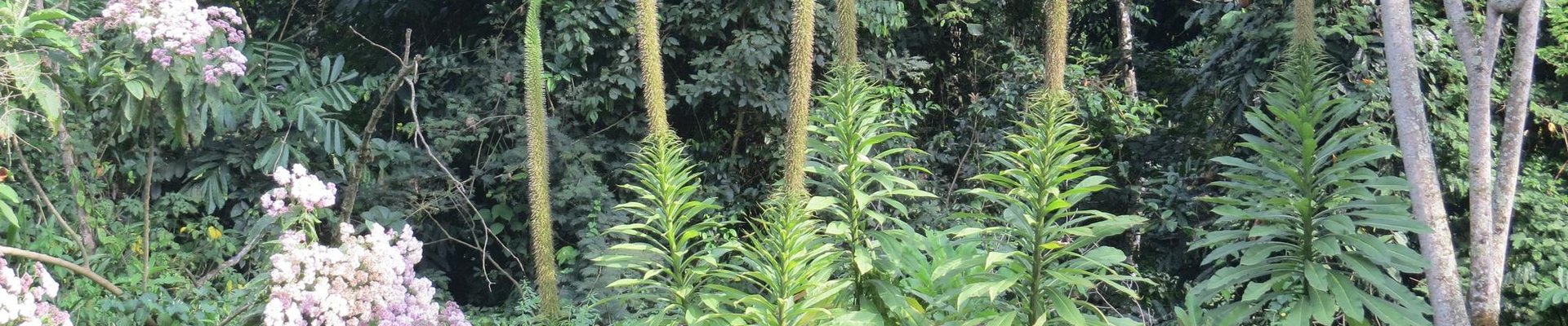
This mountain range with steep slopes ranges from 1,670m to 5,109m in altitude. Its highest peaks have permanent snow fields and glaciers. It also constitutes a vital water catchment area, sheltering the highest and most permanent sources of the River Nile. Due to high and regular rainfall, the area is home to luxuriant and unusual flora such as giant lobelias.
Community Perspective: the park has two entries for visitors, two main entries: one at Nyakalengija and one near Kilembe. Michael and Randi have described what a day visit to the former entails, while Els covered the latter. To see the unusual flora would require a seven-day trek to the higher elevations of the Rwenzori Mountains.
Site Info
Official Information
- Full Name
- Rwenzori Mountains National Park (ID: 684)
- Country
- Uganda
- Status
-
Inscribed 1994
Site history
History of Rwenzori Mountains
- 2004: Removed from Danger list
- 1999: In Danger
- Security situation
- 1994: Inscribed
- Inscribed
- Type
- Natural
- Criteria
- vii
- x
Links
- UNESCO
- whc.unesco.org
- Official
-
- ugandawildlife.org — Uganda Wildlife Authority
- Related
-
- nomadic-by-nature.com — Rwenzori Trekking: Equatorial Snow
- rwenzoritrekking.com — Rwenzori Trekking Services
All Links
UNESCO.org
- whc.unesco.org — whc.unesco.org/
Official Website
- ugandawildlife.org — Uganda Wildlife Authority
Forum Discussion
- worldheritagesite.org — Visiting information
Related Resources
- nomadic-by-nature.com — Rwenzori Trekking: Equatorial Snow
- rwenzoritrekking.com — Rwenzori Trekking Services
News Article
- April 1, 2021 bbc.com — Uganda climate change: The people under threat from a melting glacier
- May 16, 2020 theguardian.com — Floods and rock slides from Rwenzori devastate western Uganda
Community Information
- Community Category
- Natural landscape: Mountain
Travel Information
Recent Connections
-
Perfect Inscriptions
1994 -
Megaherbs
giant groundselsSee en.wikipedia.org
-
Endemic Species that include the WHS name
Rwenzori Duiker, Rwenzori Tree Frog (Am…
Connections of Rwenzori Mountains
- Individual People
-
-
Henry Morton Stanley
First European to see the range (1889) during his expedition to rescue Emin Pasha. Highest peak named after him.
-
- Geography
-
-
World's most prominent mountains
Mt Stanley 28th most prominent (3951 m) -
Territorial Highest points
Mt Stanley (Margherita Peak) 5110m/16765ft. Uganda/DRC -
Highest (over 5000m)
Mount Stanley (5109m) -
Glaciers
"In 1906 the Rwenzori had 43 named glaciers distributed over 6 mountains with a total area of 7.5 km?., about half the total glacier area in Africa. By 2005, less than half of these survive, on only 3 mountains, with an area of about 1.5 km?" -
Contiguous separate sites across national boundaries
Contiguous with Virunga, Uganda vs DR of the Congo -
On National Border
On DRC border -
Nile
the glaciers of the Rwenzori park are seen as one of the sources of the Nile
-
- Trivia
-
-
Greatest Altitude Variations
1700 - 5119 (Mt Margherita): 3419m difference
-
- Ecology
-
-
Chimpanzee habitat
-
Megaherbs
giant groundselsSee en.wikipedia.org
-
Elephants
African elephant (forest elephant) -
Endemic Species that include the WHS name
Rwenzori Duiker, Rwenzori Tree Frog (Amietia ruwenzorica) -
Strepsirrhini
dusky bushbaby, dwarf bushbaby
-
- World Heritage Process
-
-
Perfect Inscriptions
1994 -
Former In Danger List sites
1999-2004
-
- WHS on Other Lists
-
-
Centres of Plant Diversity
Af77 Rwenzori Mountains - "The higher altitude zones, covered by heath and Afro-alpine moorland, extend from around 3,500 m to the snow line and represent the rarest vegetation types on the African continent. Significant species include the giant heathers, groundsels, lobelias and other endemics" -
Biodiversity hotspot
Eastern Afromontane -
WWF Global 200
Terrestrial, Tropical and Subtropical Moist Broadleaf Forests: (7) Albertine Rift Montane ForestsSee web.archive.org
-
Ramsar Wetlands
Rwenzori Mountains Ramsar SiteSee www.ramsar.org
-
World Heritage Forest Programme
-
- Timeline
-
-
Pliocene
The mountains formed about three million years ago in the late Pliocene as a result of an uplifted block of crystalline rocks such as: gneiss, amphibolite granite and quartzite,[1] "pushed up by tremendous forces originating deep within the earth's crust". (Wiki)
-
- Visiting conditions
-
-
No road access
On foot -
Foreigner prices
Park fees: 15,000 UGX for East African Community passport holders, 25 USD for foreign residents and 35 USD for other foreigners.
-
- WHS Names
-
-
Named after a Mountain
"a range of mountains in eastern equatorial Africa, located on the border between Uganda and the Democratic Republic of the Congo. The highest peak of the Ruwenzori reaches 5,109 metres (16,762 ft), and the range's upper regions are permanently snow-capped and glaciated. Rivers fed by mountain streams form one of the sources of the Nile" (Wiki)See en.wikipedia.org
-
- Literature & Film
-
-
Marvel Cinematic Universe
Black Panther, aerial footage of park used to portray fictional nation of Wakanda
-
News
- bbc.com 04/01/2021
- Uganda climate change: The people …
- theguardian.com 05/16/2020
- Floods and rock slides from Rwenzo…
Recent Visitors
Visitors of Rwenzori Mountains
- A. Mehmet Haksever
- amychemu
- Aspasia
- Atila Ege
- Bram de Bruin
- Digits
- Dolemite92
- DouglasR
- Els Slots
- Gernot
- H Beswick
- Iain Jackson
- Jeffrey Chai
- KarenBMoore
- Loic Pedras
- Martin
- Michael Ayers
- Mihai Dascalu
- Nihal Ege
- PabloNorte
- Peltzi
- Philipp Leu
- Priyaranjan Mohapatra
- Randi Thomsen
- Roman Bruehwiler
- Solivagant
- Svein Elias
- Thomas van der Walt
- Tim Allen
- Vanessa Buechler
- Wo_ko
- Zoë Sheng
Community Reviews
Show full reviews
Our second World Heritage Site on our Uganda road trip september 2025.
We started our day hike from the Mihunga main gate (Nyakalengija), heading into the Rwenzoris. As others have noted, it takes several days of trekking to reach the alpine zone with its unique flora – similar to what we were lucky enough to experience on Mount Kenya around 3,500 meters, earlier this year.
Our hike covered about 10-11 kilometers return with 500–600 meters of elevation gain. The first four kilometers were fairly gentle, following a good trail through lush rainforest and fern forest, with two river crossings and a few ladders, before reaching the first shelter.
From there, the trail became much steeper. We had hoped to climb high enough for a clear view of the peaks, but to get there you’d likely need to continue all the way to the first camp at Nyabitaba – about 1,000 meters of ascent and 10 kilometers one way. That makes for a very long and strenuous day, more than we were ready to take on.
Even without the big panoramia, the hike was rewarding. The rainforest was vibrant and full of life, with butterflies, wildflowers, wild bananas, and dense ferns creating the atmosphere of true wilderness. We also spotted both red-tailed monkeys, colobus monkeys and even an chimpanzee along the way. An armed park ranger accompanied us – and while I believe that’s mandatory, the path was easy to follow and well marked.
The drive to Mihunga gate added to …
Keep reading 0 comments
I can't add much new to this site. I did even less hiking than Els doing only 4.75km to the first camp and then back to the main gate. It is easy to add this to any itinerary but not usually offered by your agencies by default as they don't expect tourists wanting to visit. The road from Kasese is long and rough though. You won't experience anything special on your hike as the exclusive flora is deep in the range which means a 7 day trek is required. It's mainly done by hardcore trekkers. The camps will be cold, no shower, tough hiking if it's raining. The best part of my journey was the scenery around me. Surrounded by lush forest butterflies, birds, a monkey here and there is good, but the peaks in the near distance make you believe this is Jurassic Park. No road, people in sight. It's a shock when you meet a fellow trekker or porter. Most people coming to Uganda will prefer gorilla or chimpanzee trekking, safari game drives as a bonus, but adding a tough hike like Rwenzori isn't really their thing. The branded spring water sold in Uganda isn't even from the mountains.
Originally my plan was to do a night at the camp and return but seeing that it's only 2h hiking each way I said well do it quicker and I have extra day for seeing something else. I know this sounds silly but with all the other activities …
Keep reading 0 comments
Visit in December, 2020
The post made by Els for this Site is informative and comprehensive, but I will add a short review because, though my visit was also rather minimal, I utilized the alternative entry point to the park. Specifically, the gate reached by turning off the main highway at Mubuku. From there a dirt/gravel road gains 700 meters of elevation over 17 kilometers, with a variable quality, but which can be traversed by any type of common vehicle. The route follows the Mubuku River valley, which is surprisingly densely populated with rural villages. That was an issue during the previous month of May, when a severe flash-flood tore down from the mountains of the Park, taking three lives and causing significant property damage, providing another example of the misfortunes of that particular year.
I stayed at the Ruboini Community Camp, which has the benefit of being owned and operated by local residents, which keeps the monies collected close to the community and the Park. The camp has a small restaurant and cottages, which, at the time, cost $US 25 per night. These had wood-heated hot water, but the Camp had no phone or internet service. From there it is short walk to the Park gate, though when I arrived at 9:30 AM on December 23rd I was dismayed to find the gate post unoccupied. Thinking that this might have been due to the upcoming holiday, and still feeling frustrated by recent failed attempts to get to …
Keep reading 0 comments
Rwenzori Mountains National Park covers an 80km long mountain ridge in the far west of Uganda. It forms a natural border with the DR of Congo. The park attracts some 2,700 visitors a year, of which at least half are local schoolchildren. The others are mainly trekkers and mountaineers, arriving to hike a 10-day circuit or give the 3rd highest peak in Africa (Margherita’s Peak) a try. WH travellers do not often make it there: so far, only 16 claim to have visited it, while no one has written a review yet.
In preparation for my visit, I had been looking for the best access point to get into the park without having to do a multi-day hike. I found out that there are two main entries: one at Nyakalengija (with the Equator Snow Lodge and Ruboni Community Camp) and one near Kilembe. I chose the latter, as the Rwenzori Trekking Services (RTS) advertised one-day treks into the park departing from the associated Trekkers Hostel Kyanjiki. The office of the RTS, whose members accompany the hikes and maintain the trails, is also found on the hostel’s premises. The Nyakalengija trailhead is managed by another company (Rwenzori Mountaineering Services), which gets mixed reviews, especially due to its mountaineering safety standards.
So I ended up in Kyanjiki near Kilembe, itself already an extraordinary sight: it is an abandoned mining village, with lots of collapsed buildings and a broken-down cable car system. The endless rows of houses for the miners are now rented …
Keep reading 0 comments