France, Spain
Pyrénées - Mont Perdu

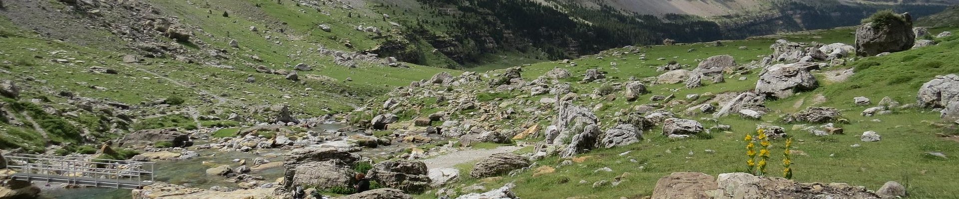
Pyrénées - Mont Perdu is a visually dramatic mountain landscape shaped by a pastoral transhumance system.
The protected area centered around the peak of Mont Perdu lies at the tectonic collision point of the Iberian and West European plates. The calcareous massif has several important geological, scenic and botanical values. A centuries-old transhumant system of grazing also continues within the area with frequent movement of herds across the French-Spanish border.
Community Perspective: On the Spanish side, the Ordesa Valley is the best suited for a visit and offers good hiking. The French side offers the Cirque de Gavarnie (you can even ski here!).
Site Info
Official Information
- Full Name
- Pyrénées - Mont Perdu (ID: 773)
- Status
-
Inscribed 1997
Site history
History of Pyrénées - Mont Perdu
- 1999: Extended
- To include the upper Valley of Héas (on the French side)
- 1997: Revision
- Partially includes Parc National dOrdesa - Viñamala
- 1997: Inscribed
- Inscribed
- Type
- Mixed
- Criteria
- iii
- iv
- v
- vii
- viii
Links
- UNESCO
- whc.unesco.org
- Official
-
- randopyrenees.fr — Mont-Perdu
- ordesapirineos.com — Parque Nacional de Ordesa y Monte Perdido
All Links
UNESCO.org
- whc.unesco.org — whc.unesco.org/
Official Website
- randopyrenees.fr — Mont-Perdu
- ordesapirineos.com — Parque Nacional de Ordesa y Monte Perdido
Community Information
- Community Category
- Natural landscape: Mountain
- Cultural Landscape: Continuing
Travel Information
Exact locations inscribed twice (or more)
Recent Connections
-
Perfect Inscriptions
1997 -
Desman
"La grande faune du site ne présente pa… -
IUGS Geological Heritage Sites
Monte Perdido massif tectonic structure…
Connections of Pyrénées - Mont Perdu
- Geography
-
-
Canyons
-
Situated on a Continental Divide
Mont Perdu French sections drains into the Atlantic Ocean Spanish sections into the Mediterranean Sea -
Cirques
the precipitous northern slopes are carved into three sheer-walled glacial cirques, including Cirque de Gavarnie (UNEP-WCMC) -
Highest cultural WHS
3,355 m -
Pyrenees
-
Glaciers
Mont Perdu/Monte Perdido Glacier (Has shrunk by 30% since 1991) -
Dark-sky preserve
Pic du Midi de Bigorre
-
- Trivia
-
-
Viewable from another WHS
Mont Perdu can be seen from the Parish church of Gavarnie (Route of Santiago in France).
-
- History
-
-
Neolithic age
Mont Perdu - several sites including the Dolmen from Tella
-
- Ecology
-
-
Bears
-
Desman
"La grande faune du site ne présente pas une valeur exceptionnelle; par contre quelques espèces comme le desman (mammifère –endémique des Pyrénées et montagnes du nord de l'Espagne)", 2017 Reactive Mission reportSee whc.unesco.org
-
Beech Forests
Ordesa and monte perdido: "At elevations up to 1,000-1,700 meters, there are extensive forests of beeches (Fagus sylvatica), Abies alba, pines (Pinus sylvestris), oaks (Quercus subpyrenaica), and a lesser extent of birches (Betula pendula), ashes (Fraxinus excelsior), willows (Salix angustifolia)." -
Otters
Ordesa -
Significant Karst Features
Outstanding example of alpine glaciated karst to 3352 m (AB ev) -
Tectonic processes
Criterion (viii): ...The region is distinguished by its location at the tectonic collision point between the Iberian and west European plates.
-
- World Heritage Process
-
-
Extended
1999: To include the upper Valley of Héas (on the French side) -
Mixed and Transboundary
-
Reduced from broader TWHS
Only partially includes former TWHS Parc National d'Ordesa - Viñamala -
Mixed sites inscribed on 5 or more criteria
Criteria: iii/iv/v/vii/viii. 3 - 3 Cultural 2 Natural -
Transboundary sites
-
Perfect Inscriptions
1997 -
Mixed and Cultural Landscape
Continuing CL -
Exact locations inscribed twice (or more)
Also part of Rock Art of the Mediterranean Bassin location no545 (Abrigo de la Ermita de San Urbez near Fanlo) situated within Pyrénées-Mont Perdu borders.
-
- Religion and Belief
-
-
Christian Pilgrimage Sites
As part of Route of Santiago de Compostela -
Legends and Folk Myths
Brèche de Roland, an abrupt gap in the crest associated in legend with the defeat of the warrior Roland at Roncevaux in Charlemagne's campaign against the Saracens (UNEP-WCMC)
-
- Human Activity
-
-
Pastoralism
The site is also a pastoral landscape reflecting an agricultural way of life that was once widespread in the upland regions of Europe but now survives only in this part of the Pyrénées (AB ev) -
Alpine ski areas in core zone
Gavarnie-Gadre Ski Resort -
Transhumance
an outstanding example of a type of transhumance that was once widespread in the mountainous regions of Europe, but which today is rare (OUV)
-
- Constructions
-
-
Cemeteries
Le cimeti?re des pyr?n?istes -
Via Ferrata
Via Ferrata de Coumély -
Tombs
Dolmen of Tella -
Cycoliths (Stone circles)
Gavarnie
-
- WHS on Other Lists
-
-
Natura 2000
"le site du patrimoine mondial est couvert par un complexe de zones Natura 2000" -
IUCN Green List
Pyrénées National Park (core area) (2014) -
European Diploma of Protected Areas
Ordesa y Mte Perdido NP -
Centres of Plant Diversity
Eu10 Pyrenees - "the region is of great interest for science and conservation, possessing a panoply of geological, panoramic, faunistic and floristic elements that make it one of the most important Alpine protected areas in Europe." -
IUGS Geological Heritage Sites
Monte Perdido massif tectonic structure -
World Biosphere Reserves
Ordesa-Vinamala (1977) covers Spanish part
-
- Timeline
-
-
Late Pleistocene
"Remains of human settlement - stone circles, caves and a dolmen - dating from the Palaeolithic (40,000-10,000 BC) have been found in the area" - it is unclear when the tradition of pastoralism started -
Eocene
Ces sédiments occupant une mer peu profonde ont été surélevés lors de la formation de la chaîne des Pyrénées il y a 40 millions d'années (wiki)
-
- WHS Names
-
-
Named after a Mountain
Mont Perdu Monte Perdido 3355m
-
News
No news.
Recent Visitors
Visitors of Pyrénées - Mont Perdu
- Adolfo
- alicemears
- Alikander99
- A. Mehmet Haksever
- Ammon Watkins
- Angela Vandyck
- Argo
- Atila Ege
- AustralLights
- BaziFettehenne
- Bin
- BobSmithseestheworld
- Brendan Carroll
- Caspar
- Cezar Grozavu
- Christian Wagner
- Claire Bradshaw
- Clyde
- Cobaltrage
- Corinne Vail
- Daniel Chazad
- Daniel R-F
- Dan Pettigrew
- Dirk-pieter
- DutchHorn
- Dwight Zehuan Xiao
- Ellen Nielsen
- Els Slots
- Eva Kisgyorgy
- Fan Yibo
- Femke Roos
- Francky D'Hoop
- FS
- GeorgeIng61
- HaraldOest
- Harry Mitsidis
- Hasco
- Hubert
- Iain Jackson
- Ingemar Eriksson
- Ivan Rucek
- Jakob F.
- Jana and Matt
- Janina Lehmann
- Jarek Pokrzywnicki
- Jasam
- Jean Lecaillon
- Jeanne OGrady
- Jezza
- Joel on the Road
- Jonas Kremer
- jonathanfr
- Jon Eshuijs
- jonstst
- KarenBMoore
- KateY
- Kbecq
- KeithBailey
- Kevin247
- krtek
- Kurt Lauer
- Laetitia Yin
- Lara Adler
- Loic Pedras
- Lucas Del Puppo
- Luis Filipe Gaspar
- Maciej Gil
- Maciej Gowin
- Mahuhe
- Małgosia Łupicka
- M. Huineman
- michaelsballard
- Mikko
- MMM
- Nihal Ege
- Nikolay Marinov
- PabloNorte
- Patrik
- Paul Schofield
- Persian Globetrotter
- PeterH
- Petri Jurescu
- Petteri
- Philipp Leu
- Philipp Peterer
- Pieter Dijkshoorn
- Rahelka
- Ralf Regele
- Randi Thomsen
- rivr
- Rodinia
- Roel Sterken
- Roger Ourset
- Roman Bruehwiler
- Rosemary
- Sabrina Liebehentschel
- Schnitzel
- scubarrie
- Shandos Cleaver
- Shannon O'Donnell
- sibariam
- Solivagant
- Stanislaw Warwas
- Szucs Tamas
- Tamara Ratz
- Tarquinio_Superbo
- Tevity
- Thomas Buechler
- Thomas Harold Watson
- Thomas van der Walt
- Tim Allen
- Tinamu
- Tom Flaten
- Tonisan
- triath
- Truls Brekke
- Tsunami
- Van Hung
- Viaje al Patrimonio
- voyager
- Walter
- Wieland
- Wojciech Fedoruk
- Xiquinho Silva
- Zoë Sheng
Community Reviews
Show full reviews
This report has to do with the French side. The main place to visit is Gavarnie, the site of one of the three "Cirques" in the area.
In visiting a WHS I don't think I have experienced so many "twists" as I did with this Pyrenees WHS.
When I was planning a trip to finish mainland France in winter 2019-2020 (just before the pandemic), I realized that it was better to visit all national / nature park-related WHS in France / Andorra in summer, not only because you can see more, but because public transportation is more frequent. So I postponed my visit to this Pyrenees WHS until some summer later.
Then, when I was planning such trip to visit this and other French / Andorra WHSs in summer 2022, I came across the following statement on the top page of the Gavarnie-Gedre Ski Resort: "In winter, near the Cirque de Gavarnie, discover a ski area ... in the heart of a UNESCO World Heritage Site!"
Pardon??? In the heart? You mean in the core zone? It can't be true! (I had in my mind the Bansko Ski Resort at the Pirin National Park WHS in Bulgaria where the ski area lies within the buffer zone surrounded the the core zone.) Upon my careful inspection of the WHS map, however, I concluded that at least one of the ski lift stations was within the core zone. I was fascinated by the idea …
Keep reading 0 comments
Unlike the previous reviewers, I visited the French part of the World Heritage Site, to be more precise the Cirque de Gavarnie. The Cirque is a deep, amphitheatre like valley formed by glaciers, with steep, very high cliffs (the mountains rise up to 1500 meters above the valley floor). It is also home to one of the highest waterfalls in Europe.
I visited the Cirque in July 2020 on a day trip. I stayed overnight in Lourdes and drove by car to the village of Gavarnie (takes about an hour). You are not allowed to enter the village center by car, but there is paid parking near it. I think, the earlier you arrive, the better. In high season, there is the real possibility of traffic jam on the small roads leading to the village. And when I arrived around 10 a.m. the parking was already quite full, too.
Even from the village - provided there are no clouds - you have spectacular views of the Cirque. After an easy hike on dirt roads (duration about one hour), I reached the restaurant at the entrance of the Cirque. From there, you can take several trails. I decided against the path to the waterfall and instead crossed the river and walked past sheep to a snow field at the foot of the rock walls. Much more challenging routes (including through the cliffs up to the Breche de Roland pass) are also available for the more ambitious hikers. But I …
Keep reading 0 comments
Like all other reviewers until now, I approached this WHS from the Spanish side through Ordesa National Park. The town of Torla is an easy and comfortable access point. At 7.30 a.m. I took one of the first shuttle buses of the day into the park. There were 10 other hikers aboard, certainly not a lot for a Saturday in July. The Mont Perdu WHS apparently sees more than 2 million visitors yearly (Spanish and French totals combined), which is hard to believe given its low-key appearance.
I had been in doubt about which hike to do: the longer trail along the ridge (Senda de los Cazadores), or the shorter one through the valley. My experiences from a few days before in the Madriu Valley made me choose the shorter trail: I am not fond of climbing a lot or getting soaking wet due to a surprise rain shower. The valley hike is still 17km long and takes 5 to 6 hours. Both trails end at the Cola de Caballo waterfall.
The valley hike has three distinct parts. It starts with an uphill slug through a forest, not the most interesting stretch and it took me 1.5 hours. Things brighten up a lot when you’re in the open at last: the path next to the river is lovely. I especially liked all the flowers in bloom, their colours and their smell. After a series of steep waterfalls, you’ll reach the alpine plateau with views of Mont Perdu. It …
Keep reading 0 comments
In May 2014, we spent three days in the National Park Ordesa y Monte Perdido, the Spanish part of this transnational WHS. Beside the Monte Perdido summit the inscribed area comprises four deep valleys that are accessible to hikers: Ordesa, Añisclo, Escuain, and Pineta. We went for two hiking tours in the Valle de Ordesa and one in the Canyon de Añisclo .
There are hardly any roads in the National Park, one of the few is the access road (HU-631) to the Añisclo valley from Escalona. The ride on this very narrow and winding road was exciting and offered wonderful views into the deep gorge. After 12 km we reached the parking lot at the Ermita de San Urbez. The Añisclo valley is a very narrow canyon between steep, almost vertical cliffs. The hiking trail runs continuously uphill along the Bellos river and through forest and lush vegetation. It is easy to walk, there are only a few steep sections. After about 3.5 hours we reached the Fonblanca waterfall and returned on the same route to the parking lot. We enjoyed very much our hike through this striking landscape, but the Valle de Ordesa was even more impressive.
The starting point for tours in the Valle de Ordesa is the picturesque village of Torla. From there it is only 5 kilometres to the parking lot Pradera de Ordesa (at 1350 metres altitude) where several hiking trails start. Ordesa is very popular with hikers and climbers, the parking lot is …
Keep reading 0 comments
I visited this WHS in May 2014. I spent 3 days hiking in the Ordesa Valley and I saw Mount Perdu both from strenuous uphill trails like Faja de Pelay at high altitude (not suitable for those who don't have a head for heights) as well as from the easy trail in the valley with lovely cascades, streams and waterfalls. I must say that the most picturesque hike is indeed the easy hike by the Rio Arazas which takes about 7-9 hours if you stop for lunch and to take lots of photos. If you start early at around 7am you will beat the crowds and it really is a very enjoyable trek with rainbows forming early in the morning over the many cascades and waterfalls. The UNESCO plaque is immediately visible after a few minutes of hiking. The Cola de Caballo waterfall is beautiful but you should arrive early there as it's also the place where everyone stops to have lunch. I was surprised that I didn't have to pay an entrance ticket of any sort. All you need there are good hiking shoes and an empty bottle to fill with pure water from the gushing streams. During 3 days of hiking I spotted the rare Lammergeier (Bearded Vulture) amongst different birds of prey and scavengers as well as smaller birds. I was lucky to spot a couple of marmots and 2 big castors near Cola de Caballo and I also enjoyed the varied mountain flora with different kinds …
Keep reading 0 comments
WHS-collectors should do this beautiful hike first: from the eastern end of the Pradera de Ordesa, cross Río Arazas and climb steeply up through the woods on the valley's south side. This hardest part, called "Senda de los Cazadores" (Hunter's Path), in which you ascend 600m, takes an hour. Then it's level or downhill all the way along the high Faja de Pelay path to the 'Circo de Soaso', a rocky balcony whose centrepiece is the Cola de Caballo (Horsetail) waterfall. Return by the easy path along the bottom of the valley, passing through several waterfalls. This circuit takes 7 hours, so bring those picnic sandwiches and mineral water. (Summer 2010)
Keep reading 0 comments
The scenery in the Ordesa Valley I found reminiscent of that of Yosemite: high rock walls with numerous waterfalls. I reached the park by travelling by bus from Sabananigo (on the Jaca to Zaragoza rail line) to the attractive village of Torla. After paying the 4.50 euros to enter the Ordesa National Park I boarded the free bus that stopped first at the visitor centre at the entrance to the park, then at the Pradera car park inside the park. This is the starting point for a number of walking tracks around the park. By following the Rio Arazas to the WHS plaque I reached the view of Mount Perdido.
Keep reading 0 comments