Denmark
Møns Klint


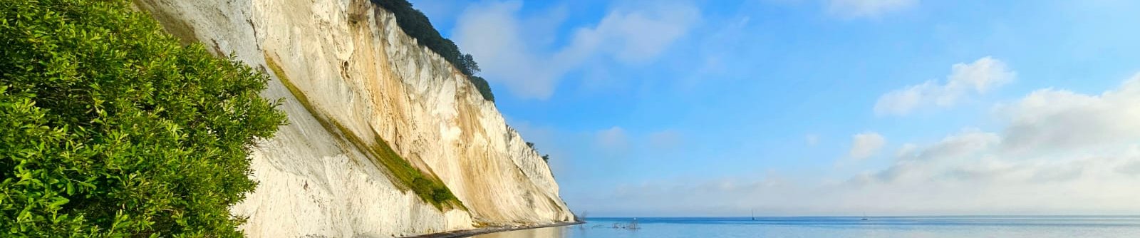
Møns Klint is a 6km long coastal chalk cliff displaying the impact of glaciotectonics.
The cliff developed from the effects of glaciation during the last Ice Age: it’s a former seabed pushed upwards and into folds. The process is exposed in visible layers in these cliffs. Some of the cliffs fall a sheer 120m to the sea below. Ongoing erosion brings new insights into its geological history and exposes fossils.
Community Perspective: Reviewers mostly enjoyed the sheer height of the cliffs, the scenic landscape and hiking opportunities. It's easiest to reach by car, but in summer, buses run all the way to the GeoCenter from Stege.
Site Info
Official Information
- Full Name
- Møns Klint (ID: 1728)
- Country
- Denmark
- Status
-
Inscribed 2025
Site history
History of Møns Klint
- 2025: Advisory Body overruled
- ICOMOS advised Referral
- 2025: Inscribed
- Meets criterion 8
- 2023: Added to Tentative List
- Added to tentative list
- Type
- Natural
- Criteria
- viii
Links
- UNESCO
- whc.unesco.org
All Links
UNESCO.org
- whc.unesco.org — whc.unesco.org
Community Information
- Community Category
- Natural landscape: Eroded
Travel Information
Recent Connections
-
Orchids
18 species of orchids (AB ev)
-
Chalk
the property includes chalk cliffs (OUV…
-
Flint extraction
"The impact of the geological heritage …
Connections of Møns Klint
- Geography
-
-
Dark-sky preserve
Møns Klint overlaps with ... a Dark Sky Park. (AB ev) https://darksky.org/news/mon-and-nyord-designated-scandinavias-first-ida-dark-sky-places/
-
Baltic Sea
Lies at "the easternmost part of the Island of Møn in the southeastern Danish archipelago in the Baltic Sea" (AB ev)
-
- Ecology
-
-
Beech Forests
"crowned by green beech tree forests on top" (OUV statement)
-
Orchids
18 species of orchids (AB ev)
-
Tectonic processes
"a well exposed cross section through one of the world's largest glaciotectonic complexes" (OUV crit viii)
-
Fossils
The Cretaceous chalk is rich in fossils, particularly of the diverse benthic fauna which are constantly exposed by erosion and found on surrounding beaches. (AB ev)
-
Chalk
the property includes chalk cliffs (OUV statement)
-
- World Heritage Process
-
-
Inscribed on a single criterion only
Crit VIII
-
- Human Activity
-
-
Flint extraction
"The impact of the geological heritage has shaped local history from land use practices to material culture, e.g. prolonged use of flint stone in tool making." (AB ev)
-
- WHS on Other Lists
-
-
World Biosphere Reserves
In addition, Møns Klint overlaps with the UNESCO Biosphere Reserve Møn (AB ev)
-
Natura 2000
In addition, Møns Klint overlaps with a Natura 2000 Site (area no. 171) (AB ev)
-
- Timeline
-
-
Late Pleistocene
Formed by fast-flowing Pleistocene glaciers: "Approximately 17,000 years ago, during a period known as the Weichselian glaciation, immense glaciers pushed and folded the ancient seabed, thrusting the chalk upwards to create the impressive landscape we see today. This timeframe, falling between 129,000 and 11,700 years ago, places the formation of Møns Klint firmly within the Late Pleistocene." (Google gemini)
-
- Science and Technology
-
-
Scientific Developments
The site has played a key-role in the scientific history and acknowledgement of glaciotectonics, including important methodological contributions to the scientific discipline of glaciotectonism.
-
- WHS Names
-
-
Untranslated Toponyms
Klint = "a geological term of Scandinavian origin describing a coastal cliff or escarpment; the term has its roots in the Old Norse word "klint," meaning cliff."
-
News
No news.
Recent Visitors
Visitors of Møns Klint
- Albert
- Alexander Lehmann
- Ana Lozano
- Argo
- Ask Gudmundsen
- Astraftis
- Bill Maurmann
- Bodil Ankerly
- Catoplayer
- Christoph
- Christravelblog
- Csaba Nováczky
- ctravel
- Daniel Chazad
- Dan Pettigrew
- Echwel
- emvcaest
- Eva Kisgyorgy
- Farinelli
- Feldhase
- George Gdanski
- Hadrianus
- Harald T.
- henrik_hannfors
- Ingrid
- Ivan Rucek
- Jarek Pokrzywnicki
- Jean Lecaillon
- JobStopar
- Jonas Kremer
- Jonas Martinsson
- Kbecq
- Kurt Lauer
- Lukasz Palczewski
- Martina Rúčková
- MichaelH
- nikolasruffet
- Olli-Pekka Turunen
- Patrik
- Peter Lööv
- Philipp Peterer
- Rachel Perkins
- Randi Thomsen
- Roger Ourset
- Roman Bruehwiler
- Roman Raab
- serghei.belous
- Stanislaw Warwas
- Svein Elias
- Szabolcs Mosonyi
- Tony H.
- Tsunami
- Valentina
- Westwards
- Wojciech Fedoruk
- Zoë Sheng
Community Reviews
Show full reviews
I visited Møns Klint on a beautiful summer day in 2016, followed by Stevns Klint (WHS) later that same day. While both are impressive, I remember talking to my fiancée about how Møns Klint should be a WHS (it wasn't even a TWHS at the time). It brings me again to a question I often wonder: some sites really have it all, but what makes a great WHS otherwise? Is it more about being spectacular even to a visitor who lacks background knowledge about the site's significance? Or does real value lie in historic/scientific/religious importance?
I must admit it's often the former for me. To take this example, I understand and appreciate that Stevns Klint is more significant in terms of geology but the maximum height of its cliffs is about 40 meters, while some cliffs at Møns Klint rise to about 120 meters. Plus with the great hiking trails through the woods, the viewpoints, the rocky beach and the pristine waters, it's simply stunning, probably the most beautiful place I've seen in Denmark. I'm not challenging the status of Stevns Klint as a WHS, but if it's on the list, Møns Klint should be there too.
Keep reading 0 comments
Møns Klint claims its OUV from the glacial landscape formation and being part of one of the world's largest glaciotectonic complexes. But much more significant what is described as “scenic value”, which means the cliff is simply nice to look at.
As the aesthetics are a big part of this, I selected a day for the visit I knew the sun would shine. We took a rental car from Copenhagen Airport and drove there, with a detour to Roskilde and a stop at the unimpressive Borgring. Once you are off the freeway, the drive is very scenic, with typical Danish landscape, great old houses and lots of green. You can drive to the GeoCenter Møns Klint, where there is parking (6 EUR for 1 day), walking paths and stairs to the beach.Getting there by public transport is possible I guess, but you would need to take a train to Vordingborg, a bus and still find a solution for the last 6km. So, I would not recommend it.
At the GeoCenter we opted for hike number 4, further up north along the cliff through the forest, down the stairs and back along the beach. The hike was fantastic, with great views at the cliff. I assume the views might be more restricted once all the trees have their leaves back. Unfortunately, the info board at the GeoCenter did not mention, that the stairs we were supposed to use as a turning point, were closed (and it seems not since …
Keep reading 1 comment