Andorra
Madriu-Perafita-Claror Valley


The Madriu-Perafita-Claror Valley is a pastoral landscape reflecting an agricultural way of life that was once widespread in the upland regions of Europe but now survives only in this part of the Pyrenees.
The valley was a place of passage with tracks linking it to France and Spain. Shepherds, charcoal burners, miners, blacksmiths, farmers and even smugglers have used these footpaths within the Madriu river basin over the centuries. The highest part is a glacial landscape, the rest was and still is used as pastures for the grazing of cows and horses during the summer. The two settlements within the valley are only used in the summer months. Terraced fields have been constructed to grow rye, and wheat and to provide hay. The land is communally owned.
Community Perspective: Several marked trails lead into the area. But as beautiful as the scenery might be, it will not bring you closer to understanding the cultural value and one reviewer even wondered how alive the pastoral tradition really is.
Site Info
Official Information
- Full Name
- Madriu-Perafita-Claror Valley (ID: 1160)
- Country
- Andorra
- Status
-
Inscribed 2004
Site history
History of Madriu-Perafita-Claror Valley
- 2004: Inscribed
- Inscribed
- Type
- Cultural
- Criteria
- v
Links
- UNESCO
- whc.unesco.org
- Official
-
- madriu-perafita-claror.ad — La Madriu-Perafita-Claror Valley
All Links
UNESCO.org
- whc.unesco.org — whc.unesco.org/
Official Website
- madriu-perafita-claror.ad — La Madriu-Perafita-Claror Valley
Community Information
- Community Category
- Cultural Landscape: Continuing
Travel Information
Recent Connections
-
Historic climate change
"Its spectacular glacial landscapes wit…
-
Perfect Inscriptions
2004 -
Desman
"Toutefois, on retrouve, parmi la faune…
Connections of Madriu-Perafita-Claror Valley
- Geography
-
-
Highest cultural WHS
2,500 m -
Pyrenees
-
Located in a microstate
Andorra (468km2 / 71822 inhabitants) -
On National Border
On Spanish border -
Cirques
glacial cirque of Estanyons (AB ev) -
Located in a Capital City
Andorra la Vella (Capital of Andorra) -
Glaciers
Contains "rocky glaciers"
-
- Trivia
-
-
Tour de France
2016 Stage 9 did cross through the core zone in the panhandle -
Covers more than 5 percent of country
9,13%
-
- History
-
-
Historic climate change
"Its spectacular glacial landscapes with vast pastures and wooded valleys reflect climate change" (OUV statement)
-
- Ecology
-
-
Desman
"Toutefois, on retrouve, parmi la faune, des espèces particulièrement intéressantes comme le desman des Pyrénées (Galemys pyrenaicus), une petite taupe aquatique endémique du nord de l’Espagne." (Nom File)
-
- Architecture
-
-
Dry Stone Construction
Houses in the valley are made out of dry, local 'gathered' granite stone (AB ev)
-
- World Heritage Process
-
-
First inscriptions
Andorra 2004 -
Only WHS in their country
-
Perfect Inscriptions
2004 -
Inscribed on a single criterion only
v. to be an outstanding example of a traditional human settlement, land-use, or sea-use which is representative of a culture (or cultures), or human interaction with the environment especially when it has become vulnerable under the impact of irreversible change
-
- Human Activity
-
-
Man-made Terraces
-
Iron production
-
Transhumance
"The centuries-old transhumant system of grazing continues within the area. with frequent movement of herds across the French-Spanish border." (AB eval) -
Vineyards
historical vineyard -
Pastoralism
the persistence of pastoralism (AB ev)
-
- Constructions
-
-
Via Ferrata
To Rocs d'EsquersSee visitandorra.com
-
- WHS on Other Lists
-
-
UNESCO Intangible Cultural Heritage Lists
Art of dry stone construction, knowledge and techniques (2024)See ich.unesco.org
-
Ramsar Wetlands
2013
-
- Timeline
-
-
Built in the 13th century
the origin of the communal land ownership system
-
- Visiting conditions
-
-
No road access
On foot - however if you look at page 7 of the nomination dossier, you'll see that the park border has a tip where it crosses a road. It's unsure whether one can enter the park from there.See whc.unesco.org
-
- WHS Names
-
-
Microcosm
"The Madriu-Perfita-Claror Valley is a microcosm that illustrates the way in which man has harvested the mountain resources over the past millennia." (OUV) -
Named after a River
- "The nominated area fits precisely within the basin of the Madriu River, giving it a natural coherence. This river starts its course at high level in an area of plateaus, glacial lakes and rocky glaciers, and then flows west through a large glacial valley. A secondary valley, the Perafita–Claror, enters the Madriu Valley from the south-east at Entremesaigues." (IUCN)
-
News
No news.
Recent Visitors
Visitors of Madriu-Perafita-Claror Valley
- 2Flow2
- Adam Hancock
- Adrian Turtschi
- alicemears
- Ammon Watkins
- Ana Lozano
- Andrea Szabo
- Anna Wludarska
- Argo
- Atila Ege
- AustralLights
- Bauchat
- BaziFettehenne
- Bin
- Bodil Ankerly
- Bram de Bruin
- Can SARICA
- Carlo Medina
- Cezar Grozavu
- chenboada
- Cheryl
- Christian Wagner
- Christoph
- Christravelblog
- Clyde
- Corinne Vail
- Cristina Erba
- ctravel
- CugelVance
- Daniel Chazad
- Daniel Gabi
- Dan Pettigrew
- David Aaronson
- Digits
- Dimitar Krastev
- Dirk-pieter
- Dolemite92
- Dwight Zehuan Xiao
- edstar500
- Els Slots
- Emili Xaus
- Eva Kisgyorgy
- Evgenii
- Fan Yibo
- Filip Murlak
- Frederik Dawson
- Gary Arndt
- George Gdanski
- GeorgeIng61
- GerhardM
- Gilles
- giloudepuertorico
- HaraldOest
- Harry Mitsidis
- Hasco
- Hubert
- Hurrvinek
- Iain Jackson
- Ilya Burlak
- Ivan Rucek
- Jakob F.
- James F
- Jana and Matt
- Jan Korpeg
- Jan Zimmermann
- Jarek Pokrzywnicki
- Jasam
- Jawnbeary
- Jean Lecaillon
- Jezza
- João Aender
- Joel on the Road
- Jonas Hagung
- Jonas Kremer
- jonathanfr
- Joyce van Soest
- jxrocky
- Kbecq
- Kevin Padley-Knight
- KngAlaric
- Knut
- krtek
- Kurt Lauer
- Lado Joel
- Lara Adler
- Loic Pedras
- Luis Filipe Gaspar
- Maciej Gil
- Mahuhe
- Maja
- Małgosia Łupicka
- MarcoB_0
- Martinacurra88
- Martina Rúčková
- Marty
- Matthewsharris
- Max
- MH
- M. Huineman
- michaelsballard
- Mikko
- MMM
- Monica Tasciotti
- MoPython
- Mstrebl1990
- napalm
- Nihal Ege
- PabloNorte
- Patrik
- Paul Schofield
- Persian Globetrotter
- PeterA
- PeterH
- Petri Jurescu
- Petteri
- Philipp Leu
- Philipp Peterer
- Piotr Wasil
- Porcho
- puessergio
- Purrfect
- Rahelka
- Ralf Regele
- Randi Thomsen
- Riccardo Quaranta
- Roger Ourset
- Roman Bruehwiler
- Schnitzel
- scubarrie
- Sergio Arjona
- Shandos Cleaver
- Shijie ZHU
- Slavi
- Solivagant
- Sorel Americo
- Stanislaw Warwas
- Szucs Tamas
- Tamara Ratz
- Taotao Chen
- Tarquinio_Superbo
- Thomas Buechler
- Thomas van der Walt
- Tim Allen
- Timothy C Easton
- Tinamu
- Tonisan
- triath
- Tsunami
- Vincent Cheung
- WILLIAM RICH
- Wojciech Fedoruk
- Xander Huang
- Xiong Wei
- Yongcheng Liu
- Zoë Sheng
Community Reviews
Show full reviews
This is an area with some very beautiful hikes! I recommend a visit after seeing it in May 2025!
Now, whether this site is of "outstanding value to humanity", as many reviewers have commented, is debatable. As Els mentioned in her review over a decade ago, it's questionable the extent to which this site "reflects the persistence of pastoralism and a strong mountain culture, notably the survival of a communal land-ownership system dating back to the 13th century" as the inscription claims. The Madriu-Perafita-Claror Valley is located decently near Andorra's main highway that connects the whole country, and is close to the city of Encamp, which itself feels fairly like a mix of any generic Western European nation blended together with any outdoorsy city in the the modern American West. The amount of people doing intense outdoor biking and the number of trendy outdoor gear shops astonished me, but I didn't see anything that really reminded me of "pastoralism".
If you treat this as simply a nice hike with the added bonus of you getting to "check" a WHS (or a visit to Andorra, for that matter) off your list, then I think you will enjoy this. There are a whole host of trails, and the Valley's official website has a ton of different recommended routes (13 as of this writing) categorized by "Low", "Moderate", or "More" difficulty. If you are extra particular about trying to immerse yourself in the "core" zone of the WHS region …
Keep reading 0 comments
Visited June 2024.
As this is one of my first reviews, I will aim to limit myself just to the important information reviewers before me have not covered. The situation seems to have changed somewhat since the signage situation was most recently reviewed, which is principally what I will cover here.
As with all my trips, I challenged myself to do this without my own vehicle or any private vehicle.
I'm hardly a strong hiker and always conscious of doing stuff like this by myself. Like many other reviewers, I opted for the route to the Fontverd Plateau and found it -- if not nothing -- completely accessible and felt safe the whole time.
Andorra La Vella is more giant mall than European capital, so I opted to see this site en route from Toulouse to Barcelona, making use of the Andbus service leaving at 9:45 from Toulouse and arriving in Barcelona around 23:00. It would also be doable as a daytrip from Barcelona, but not from Toulouse as it leaves too little time in Andorra itself.
I took the bus through the parish of Encamp (not to be confused with the town of Encamp which is quite far from where you'll want to be). From here it is a short walk to the starting point of the 'Lakes Circle'. All the 'information points' I saw listed in Google Maps in this area appeared to have been closed for some time. Perhaps this is …
Keep reading 0 comments
I hiked from Escaldes (start from Hotel Muntanya on Avenida Carlemany close to the square with the Carmen Thyssen museum), there is a signboard Cami de la Canaleta, this is the shortcut that leads to the Repsol gasoline station, cross the road, and continue steep uphill on Cami de la Muntanya, this leads you in about 45 min to the official entrance with signboard of this UNESCO site. Around here is also a big parking, it is the same road that passes here to Engolasters, first the village with the San Miquel church, then the lake. But just to say: You can do it without renting a car in Andorra which was in my case impossible on an extended weekend Andorra was loaded with tourists, mostly from neighboring Spain. About 30 minutes into the hike from the parking comes the first waterfall, and stone houses as well.
Keep reading 0 comments
I visited this WHS in April 2017 with my wife and dog. Signage seems to have improved since the visits of previous reviewers, as there's now at least a "Welcome to the WHS" sign (two of them, in fact!).
We drove our car up to the hotel at the top of Engolasters and parked in their parking lot, before walking into the forest. It's about 90 minutes walk from here to the start of the site, and it's a very pretty trail through pine forest, over rocks and through a small tunnel as well. For most of it there are great views back to the city of Andorra La Vella.
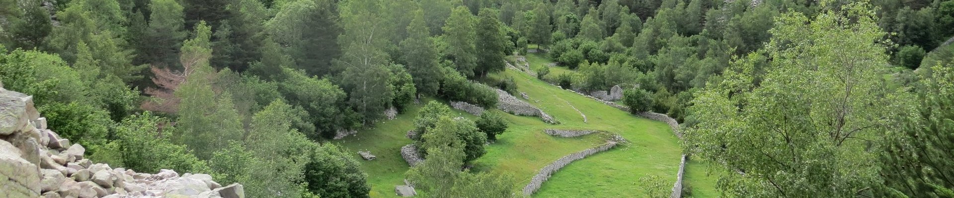
There is a look-out at the border of the actual world heritage area from where you can see most of the valley, but since all three of us were tired we took some photos and decided to turn back. Pressing on would have required a serious downhill walk and then a serious uphill walk as well! You can see some evidence of the shepherd's huts and trails from this vantage point, albeit at quite some distance.
Overall it's not the greatest site we've been to so far, though if we'd started earlier and been fitter we might've found it more interesting!
Keep reading 0 comments
The Madriu-Perafita-Claror valley is the last remnant of a pastoral landscape in Andorra, whereas the rest of the small country has developed during the past decades almost entirely in a ski resort and a shopping paradise for bargain hunters. The valley has been preserved mainly because it is connected with the rest of Andorra only by small paths, there are no roads.
We visited the valley in May 2014. The tourist website of Andorra suggests several hiking routes within the inscribed area, we had chosen the Madriu valley route: a 13.5 km route starting in Les Elcades alongside the Madriu river up to the Lake Bova, and on the same route back. We started our hike at the old Pont d'Escaldes and followed the Carni de la Muntanya uphill. This section is already in the core zone of the WHS. After one kilometre, near the crossing of the Road Cornella I de la Plana and the Road to Engolasters, we reached the area of the National Park. An information board explains the flora and fauna of the valley, but there is no WHS sign. The route runs constantly uphill, in the first two thirds on a stone paved path, certainly convenient in the past for donkeys and mules, but strenuous for hikers, in particular downhill and as on our tour, because the stones were slippery from the rain in the night before. We passed drystone walls, terraced fields and huts, but we've seen no cattle and no shepherd. The valley …
Keep reading 0 comments
This WHS can only be reached on foot: there are no roads leading into the core zone. I started from the kiosk just below the Hotel Camp del Serrat at the Lake of Engolasters (where I stayed overnight). The kiosk gives away hiking maps, and I was handed one focused on the Madriu Valley including explanations on why it’s a WHS and what’s to see. So the Andorrans must have improved on advertising their only site on the List. There still are no signs however, so you’ll have to do without souvenir pictures of yourself posing before a “Welcome to Madriu WHS” signboard.
I had chosen to do the Fontverd route, a 13km hike to the Fontverd plateau which has a refuge and a cabin. This route partly follows the red-and-white striped GR-11 long-distance path into the valley. The trail is easy to find and you do not really need a map. What I did use the map for is to look for some 'things to see' in the valley of cultural value. They are few and far between: some Orri (shepherd's huts) are shown, but all are deep into the mountains and not near to any of the easier hiking trails. So I just decided to enjoy the walk and let the surroundings surprise me.
The core zone starts from the Col Jovell, about 45 minutes into the hike and after a steep ascent. Just over the edge of this mountain ridge is the best view into the valley …
Keep reading 0 comments
I visited this WHS in May 2014. There was no information apart from a few hiking trail signs and no sign anywhere informing people that this is a WHS or indeed a national park for that matter. Over the internet I found a list of different trails that do pass from the main core zone of this WHS and since I didn't want to spend days of hiking after having visited the Ordesa Valley a couple of days before, I opted for the shorter hike from Encamp to Engolasters which offers a couple of panoramic views and a few streams of water from the melting snow on the mountain peaks. In Engolasters, at 1616 metres, there is a lake in a glacial depression with clear turqoise water and plenty of fish. There's also a small church originally built in the 11th-12th century called Sant Miquel d'Engolasters which is very similar to the ones in the Val de Boi in Catalonia, Spain. Those were the main highlights of my visit together with the many birds of prey present in the valley. More effort should be made by Andorra to provide some information boards along the various hiking trails and to promote this WHS instead of only promoting the many shopping centres only.
Keep reading 0 comments
I visited Andorra in July 2008, and also found little information about accessing the WHS at the Tourist Office. But I did find a minibus that went from Escaldes to Engolasters, a resort high in the mountains. From here there were a number of marked trails through the forest, one of which led to a viewpoint from where there was a panorama of the Madriu Valley.
Keep reading 0 comments
I visited this site in August 2008. The weather was very pleasant with lots of sunshine and a cooling breeze at higher levels.
This site is also a National Park, which is (I think) co-terminous with the WHS.However I found no WHS plaque nor acknowledgement of its NP status.I saw no NP staff, nor interpretative material of any sort, only a very few footpath signs (tho' the system of paint flash waymarks was mostly very good) and no signs of agriculture or forestry. What few buildings there were seemed to be abandoned and there appears to be no public vehicular access.
This is a cultural site but nothing seems to be done to tell the visitor what (s)he is looking at.
Given the Andorran predeliction for covering all available land with shopping centres and/or ski resorts the cynical might conclude that this area was recognised as too remote and too steeply sloping to have any such potential and therefore designated as a NP and WHS in the hope of bringing in the tourists and their money that way.
To try and get a feel for the site I had decided to follow a route which a leaflet from the Tourist Office told me had a Difficulty rating of "Medium to High" and involved a climb of 970m. With an hours walk at the beginning and end to and from Escaldes to the Start point I anticipated quite a tough day.
Having been a bit grumpy so far in this review …
Keep reading 0 comments