Sweden
Laponian Area


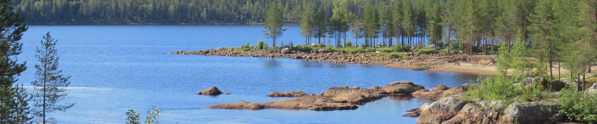
The Laponian Area is a vast Arctic landscape that is inhabited during the summer by some 200-250 indigenous Saami people.
They fish in the area and practice reindeer husbandry. The Saami arrived here some 4000-5000 years ago and turned to herd domesticated reindeer in the 17th or 18th century. The 9400 square kilometres of wilderness is part mountains, part taiga lowlands. Natural features include mires, wetlands, glaciers, moraines, canyons, ravines, and boulder fields.
Community Perspective: The 9 components cover a vast area and it takes multiple days to do this site justice (use Gallivare as a base). Muddus National Park is a good option for short hikes, and Stora Sjofallets NP for the views. The Ajtte Museum in Jokkmokk is recommended for an insight into Saami culture. Nan describes his experience with the 35km of the Rallarstigen hike.
Site Info
Official Information
- Full Name
- The Laponian Area (ID: 774)
- Country
- Sweden
- Status
-
Inscribed 1996
Site history
History of Laponian Area
- 1996: Revision
- Includes former TWHS Sjaunia (1990)
- 1996: Name change
- At inscription, its name was changed from "The Lapponian Area" to "The Laponian Area"
- 1996: Inscribed
- Inscribed
- 1990: Deferred
- As former TWHS Sjaunia: Full evaluation required
- Type
- Mixed
- Criteria
- iii
- v
- vii
- viii
- ix
Links
- UNESCO
- whc.unesco.org
- Official
-
- laponia.nu — Laponia - World Heritage Site in Swedish Lapland
- Related
-
- samer.se — About the Sápmi
- laponia.info — Focus Laponia - Ájtte Museum
All Links
UNESCO.org
- whc.unesco.org — whc.unesco.org/
Official Website
- laponia.nu — Laponia - World Heritage Site in Swedish Lapland
Forum Discussion
- worldheritagesite.org — Laponian Area lodging
Related Resources
- samer.se — About the Sápmi
- laponia.info — Focus Laponia - Ájtte Museum
News Article
- Aug. 18, 2021 reuters.com — Sweden's once-highest peak loses 2 metres height in year as glacier melts
Community Information
- Community Category
- Natural landscape: Glaciation
- Human activity: Agriculture
Travel Information
Recent Connections
-
WHS with enclave
At least 5 enclaves can be seen on the …
-
Full White Nights
-
Extension Supported
"would welcome the consideration of a t…
Connections of Laponian Area
- Geography
-
-
Arctic
-
Glaciers
Sarek NP contains over 200 glaciers, Stora Sjöfallet NP's "most prominent sights are the peaks and glaciers of the Akka range". -
On National Border
On Norway border -
Lapland
-
River deltas
Rapa River Delta -
Cirques
Well-developed geomorphological features that illustrate the origin and ongoing processes in the area include ... glacial cirques... (AB ev) -
Full White Nights
-
- Trivia
-
-
Slow Food Movement
Reindeer Suovas (smoked meat) -
Tourist Treks
The Kungsleden (King's Way) -
Minority communities
Saami
-
- Ecology
-
-
Taiga
-
Peat
"(Sjaunja Nature Reserve) contains the largest mire (peat -based wetland) in all of Western Europe outside the Soviet Union." (AB) -
Permafrost Mounds
"A wide variety of features illustrating both historic and on-going geological processes are found. These include features such as ......... palsa bogs." (AB eval) -
Tundra
It bas excellent examples of ice and frost action in a tundra setting (AB ev) -
Otters
-
Bears
Brown bear -
Inselbergs
Well-developed geomorphological features that illustrate the origin and ongoing processes in the area include monadnocks... (AB ev) -
Notable Trees
Muddus NP: Sweden's oldest known pine tree is also located here. It has been estimated to be at least 710 years, as it was found to have withstood a forest fire in 1413. (wiki) -
Swamps and Marshes
"a variety of swamp types cover another 1,000km2, the latter being the largest untouched mire complex in western Europe" (AB ev) -
Eagles
White-tailed sea eagle, golden eagle (Official description) -
Strict Nature Reserve
Partly: Sjaunja Nature Reserve. Visitor access seems not to be restricted, as "A public road which bisects the World Heritage site runs via Sjaunja Reserve through Stora-Sjöfallet Park". (UNEP-WCMC) -
Oldest National Parks
Sarek National Park + Stora Sjöfallet National Park: 1909 (oldest in Europe)
-
- World Heritage Process
-
-
Potential Transboundary sites
Norway - Tysfjord, the fjord of Hellemobotn and Rago -
Mixed sites inscribed on 5 or more criteria
Criteria: iii/v/vii/viii/ix. 5 - 2 Cultural, 3 Natural -
Extension Supported
"would welcome the consideration of a transboundary site with Norway." (Decision 20 COM VIII.B) -
WHS with enclave
At least 5 enclaves can be seen on the official map.
-
Cultural landscape not recognized
Proposed as a cultural landscape and recognized as such according to OUV crit v : a cultural landscape reflecting the ancestral way of life of the Saami people -
Extensions on Tentative List
The Laponian Area - Tysfjord, the fjord of Hellemobotn and Rago (Norway)
-
- Religion and Belief
-
-
Sacred Mountains
Áhkká in the southwestern corner of Stora Sjöfallet National Park: in the Sámi tradition it is a holy mountain (wiki)
-
- Human Activity
-
-
Pastoralism
one of the last and among the best preserved of those few [Pastoral transhumance landscapes of this kind] that survive (AB ev) -
Transhumance
one of the last and unquestionably the largest and best preserved examples of an area of transhumance (OUV)
-
- WHS on Other Lists
-
-
Ramsar Wetlands
Sjaunja, 1974 -
Natura 2000
See en.wikipedia.org
-
European Diploma of Protected Areas
Muddus National Park & Sarek and Padjelanta National ParksSee www.coe.int
-
- Timeline
-
-
Built in the 4th millennium BC
"The area ...was first occupied in the Palaeolithic period, towards the end of the last Ice Age, about 10,000 years BP. The settlers were nomadic hunter-gatherers, subsisting principally on wild reindeer.... remains of human settlement over wide areas of the site indicating a hunting and fishing culture from between 3500 and 2000 BC evolving around 2000 BC into use of trapping pit systems. Extensive reindeer domestication and nomadic life based on herding of tame reindeer did not develop until the17th and 18th Centuries" (IUCN) "This area has been occupied continuously by the Saami people since prehistoric times (having) .. arrived from the east 4000-5000 years ago ...(They) began hunting wild reindeer, like their predecessors, but slowly replaced them by domestlcated herds, wlth which they migrated during the year. They practised a form of transhumance, spending the summer in the mountains and the winters in the coniferous forests to the east. (ICOMOS) " Timeline based on arrival of Sami.
-
- WHS Names
-
-
Name changes
At inscription, its name was changed from "The Lapponian Area" to "The Laponian Area"
-
News
- reuters.com 08/18/2021
- Sweden's once-highest peak loses 2…
Recent Visitors
Visitors of Laponian Area
- Alexander Lehmann
- Anna Wludarska
- Argo
- Artur Anuszewski
- Atila Ege
- Axel Hansson
- Bamse
- BaziFettehenne
- Bin
- Birgitte Sørensen
- Cheryl
- christof
- Clyde
- Delphine Delaunay
- Dimitar Krastev
- Dorejd
- DutchHorn
- Ellen Nielsen
- Els Slots
- Erfe91
- Federico P.
- Filip Murlak
- Geert Luiken
- g.emma_bae
- George Gdanski
- Gernot
- Gilles
- Harry Mitsidis
- henrik_hannfors
- Iain Jackson
- Ian Cade
- Ingemar Eriksson
- Ivan Rucek
- Jana and Matt
- Janos
- Jarek Pokrzywnicki
- Jasam
- Joel on the Road
- Jonas Hagung
- Jonas Kremer
- Jonas Martinsson
- jonathanfr
- Kurt Lauer
- Laurey
- Li
- Liamps91
- Luis Filipe Gaspar
- Martina Rúčková
- Mikko
- MMM
- nan
- Nihal Ege
- PabloNorte
- Patrik
- Peltzi
- PeterH
- Peter Lööv
- Petteri
- Piotr Wasil
- Priyaranjan Mohapatra
- Randi Thomsen
- Remigiusz
- Roger Enarsson
- Roger Ourset
- Roman Bruehwiler
- Roman Raab
- Sabrina Liebehentschel
- Schnitzel
- Sergio Arjona
- Shandos Cleaver
- Solivagant
- Stefan Loov
- Stijn
- Svein Elias
- Szucs Tamas
- Tom Flaten
- Tsunami
- WalGra
- Walter
- Wojciech Fedoruk
- Zoë Sheng
Community Reviews
Show full reviews
In the summer of 2010 before we said goodbye to Norway, we had one final roadtrip to visit a large part of this country. We drove as far North as Lofoten, then cut across to Sweden and came back south through there. We crossed the polar circle in Norway and passed it again by a nice sign on the way back. This is the Laponian area of Sweden. There was a nice museum in Jokkmokk on the indigenous people who were living here and we found this sign on the side of the road with a detailed description. The site has both natural, hiking and people components to it. As we had limited time and were traveling with young baby we stopped at the museum, took pictures of the signs, but did not have the time for hiking or much exploring.
Keep reading 0 comments
“Nan, those are your shoes?” Me and two colleagues stood outside our company’s headquarters in Stockholm and they were having big grins on their faces. I was wearing sneakers and was desperately trying to get back into the building.
They knew what I was planning to do: Go hiking in Northern Sweden. In my hiking shoes. But those were in my bag, seven floors and one impassable security gate away. After some lamentation and plenty of cursing, I resigned and off in sneakers I went.
When researching how to visit Laponia, I settled on Muddus National Park and Stubba Nature Reserve. Both are located in the lowlands and easiest to get to and from. The other parts are more remote and more mountainous.
In addition, I found a historic trail running from Gällivare to Porjus, the Rallarstigen, which is closely related to the founding of my company: Vattenfall. Vattenfall means waterfall in Swedish. The Swedish state founded the company at the beginning of the 20th century to electrify Laponia via hydro power plants. In Porjus is one of the earliest hydro power plants built. The construction workers for Porjus hiked along Rallarstigen. And now I wanted to follow their footsteps.
To be frank: It was an amazing hike. I really enjoyed visiting and will try to come back to see the other parts. But next time in hiking shoes.
Getting There
The hub for Laponia is Gällivare. The town has an airport …
Keep reading 0 comments
I visited this WHS in June 2018. I used Gallivare as my base and stayed there for 3 nights focusing mainly on the inscribed Muddus National Park and Stora Sjofallets National Park.
The Laponian Area is a mixed WHS and is inscribed for its nature and for the Saami culture. There are protected rivers, vast boreal (taiga) forests, glaciers, mountain massifs and a landscape that bears geological testimony to its formation over eons. 4 National Parks (Padjelanta, Sarek, Muddus and Stora Sjofallet) and 5 nature reserves (Stubba, Staunja, Tjuolta Valley, Sulitelma glacier and Rapa delta) are inscribed. The national parks and nature reserves are jointly managed with the Saami people which reminded me of a similar agreement in Australia at Uluru.
For thousands of years, the Saami people lived in these mountains and forests. The sun and the wind steer people's nomadic lives here. Reindeer provide humans with food and clothing. The few Saami remains which can be seen are a number of barely visible stones in a ring on the ground which form hearths which marked the Saami's temporary homes, settlements and reindeer foraging areas.
Today Laponia is where Saami people from 9 communities live and work. They follow the reindeer herds on their seasonal foraging migrations. On a wider scale, the Swedish Laponia forms part of what is known as Lappland or Sapmi, which stretches from Norway to Russia. The best way to visit this immense area (9400 sqaure km) is either by weeks of …
Keep reading 0 comments
The Laponian Area is a big WHS comprising 9 nature reserves that need some time and research to cover. Not many general interest tourists put it on their itinerary: on the web, I mostly found trip reports about multi-day hikes, for which you have to take everything with you on your back (25 kg seems to be a minimum). Paths are scarcely marked: those who are experienced enough to hike here get along fine with GPS and/or a compass. From the comfort of my rental car, I encountered several of these long-distance hikers with their huge backpacks by the side of the road, waiting for a bus or just getting ready to start their walk.
The designated area lies north of the Arctic Circle between the towns of Jokkmokk and Gällivare. I used the latter as my base for 2 nights. The town will never win any beauty contest, but if you’re not fussy, I can recommend Gällivare B&B and the local Thai restaurant. I started my Laponian exploration with a day trip by car to Stora Sjöfallet National Park. From Gällivare, it takes 2.5 hours (184 km) to Ritsem, which is as far as you can go into the park on a paved road.
The forest landscape is beautiful against a clear sky; it often reminded me of the Jasper area in Canada. However, the views here are tainted by omnipresent mega-electricity poles that run parallel to the road to Ritsem: the area has several huge hydro-electric plants. The …
Keep reading 0 comments
From the moment we hit the road north of Skelleftea airport we felt a long way from London. The endless pine forests, lakes and sight of reindeer galloping next to the car certainly provided that disconnect from our day to day life that you hope for on a short break.
As two pretty dedicated urbanites we were out of our comfort zone and trying to get something from one of Europe's largest wildernesses in a short amount of time provided a different set of challenges for us, but I must admit I rather enjoyed my first Arctic world heritage site.
Within the world heritage site proper we visited the southern part of Muddus National Park, which marks the eastern extent of the Laponian area. We had a short hike to visit the small waterfall near Skaite, which gave us a brief glimpse of the natural aspects of the site and provided me with an extensive array of insect bites for my troubles. It was enjoyable and only took a short while to get a bit of a taste of our environs. The drive through the inscribed area also enabled us to get some nice views of the wilderness extending beyond the man-made lakes that litter the area.
We also visited the Ajtte museum in Jokkmokk which attempts to explain the virtues of the area. It was a good place to get a grip on both the natural and cultural aspects of the Sami heartland, though a few of the exhibits …
Keep reading 0 comments
My day trip to Ritsem passing through parts of the Muddus and Stora Sjofallet National Parks started from the picturesque old railway station in Gallivare. From outside the station I took a #93 bus and spent the day travelling to and from Ritsem, stopping off at several spots along the way, and taking a hike up to get a view of Mount Akka across the lake from Ritsem.
The cultural aspect of this site is a bit hard to find, and visually it doesn't compare with the more dramatic mountain scenery of the South Island of New Zealand.
Keep reading 0 comments
I visited the Laponian area in June 2009. The weather was good, sunny and warn, to the point of being able to bathe in the lakes. The Laponian area consists of 7 national or nature parks. The most intesrestings are (un)fortunately only accessible by several days trekking. Even in excellent waether condition, it is only advised for experienced trekkers, due to its remote locations, and arctic climate. Sarek National Park, which seems to be the most interesting area is therefore of reach for independant traveller.
I rented a car in Kiruna (easy and relatively cheap air acces from Stockholm) which allowed me to travael trough four of the parks. Going from the east to the west, the landscape gradually changes from lowland to mountanious. From the Malmberget to Jokkmokk main road, I took a small dirt road to the east, going to the Muddus National Park. The park preserves un undisturbed primeval forest and several deep ravine with a few waterfalls. The road stops at the park entrance, but they is several hikes (easy to walk, clerlay indicated) that follow a canyon to a waterfall.
Then I backtracked to the main road, and then took the 142 km long road west to Ritsem. The road pases the Stubba and Sjaujna nature reserves consisting mostly of lowlands. It follows the Stora Lulevatten Lake (an artificial lake actually not part of the WH site) with nice view on the moutains to the West. They are no easy hikes there.
I then reached …
Keep reading 0 comments