Finland, Sweden
High Coast / Kvarken Archipelago

The High Coast / Kvarken Archipelago shows outstanding examples of geological processes caused by glaciation.
Historical Ice Ages have shaped the landscape of these two components on opposite sides of the Gulf of Bothnia. The High Coast is important for research on isostasy, in which the land rises as the weight of the melting glaciers is lifted. This is a still continuing process that leads to the emergence of new islands and lakes. Kvarken features unusual moraine ridges (“De Geer moraines") that were formed when boulders and stones were pushed to the edge of the melting continental ice sheet.
Community Perspective: the site provides excellent views if you get to a higher viewpoint and enjoyable hiking. The area is good for birding as well. Finnish Kvarken has been covered by John (cruising) and Els (driving+hiking), while the Swedish High Coast was done by John (cruising), Clyde (driving+hiking) and Nan (public transport+hiking).
Site Info
Official Information
- Full Name
- High Coast / Kvarken Archipelago (ID: 898)
- Status
-
Inscribed 2000
Site history
History of High Coast / Kvarken Archipelago
- 2008: Name change
- From "Kvarken Archipelago / High Coast" to "High Coast / Kvarken Archipelago"
- 2006: Extended
- To include the Kvarken Archipelago, Finland
- 2006: Name change
- From "High Coast" to "Kvarken Archipelago / High Coast, Finland and Sweden"
- 2000: Inscribed
- Inscribed
- 1999: Deferred
- High Coast: Bureau - better doc of marine aspects. Also consideration of a "Cultural Landscape".
- Type
- Natural
- Criteria
- viii
Links
- UNESCO
- whc.unesco.org
- Official
-
- kvarkenworldheritage.fi — Kvarken World Heritage
- hogakusten.com — Highcoast
All Links
UNESCO.org
- whc.unesco.org — whc.unesco.org/
Official Website
- kvarkenworldheritage.fi — Kvarken World Heritage
- hogakusten.com — Highcoast
News Article
- Aug. 9, 2006 hs.fi — Kvarken archipelago: a moraine mosaic. The unique sea area was declared a UNESCO World Heritage Site
Community Information
- Community Category
- Natural landscape: Glaciation
Travel Information
Recent Connections
-
Free entrance
-
Holocene
9,600 years ago the landscape has risen… -
Ramsar Wetlands
Quark Archipelago (Sweden)
Connections of High Coast / Kvarken Archipelago
- Geography
-
-
Archipelagos
(Land Elevation) "consists of 7000 skerries and islets. The land rises by 8-8,5 mm annually and creates about 1 km2 new land every year. With this rate the land uplift will create a permanent gateway over the Kvarken in about 2500 years." -
Fjords
Several -
Full White Nights
Kvarken -
Gulf of Bothnia
Both sites are on either side of the Gulf of Bothnia -
Isostatic Rebound
Kvarken: raised shore lines and new islands showing an uplift over the last 9600years in the order of 285-294m which is the highest evident ?rebound? known -
Baltic Sea
-
Marine sites
"Note that about 71% of the property is sea" - Retrospective Statement of OUV -
Straits
KvarkenSee en.wikipedia.org
-
- Trivia
-
-
Depicted in Mizielinska Maps
Skuleskogen NPSee i.pinimg.com
-
Nudist beaches
Storsands Nature Reserve on the Mjallom Peninsula near Norrfällsviken on Sweden's "High Coast". -
On beer cans and bottles
KvarkenSee untappd.com
-
- History
-
-
Neolithic age
"toward the end of the Stone Age, and many contemporary dwelling sites have been discovered" (nom file) -
Bronze Age
Remains were found -
Iron Age
Remains were found
-
- Ecology
-
-
Taiga
-
Bears
brown bear (UNEP-WCMC) -
Swamps and Marshes
"As a consequence of the advancing shoreline, islands appear and unite, peninsulas expand, lakes evolve from bays and develop into marshes and peat fens" (AB ev) -
Peat
lakes evolve from bays and develop into marshes and peat fens (AB ev) -
Seals
the ringed seal and the grey seal
-
- World Heritage Process
-
-
Serial Transnational Sites
-
Extended
2006: To include the Kvarken Archipelago, Finland -
Country gained extra WHS by an extension
Originally High Coast (Sweden); 2006 Finland -
Inscribed on a single criterion only
viii. to be outstanding examples representing major stages of earth's history, including the record of life, significant on-going geological processes in the development of landforms, or significant geomorphic or physiographic features
-
- Human Activity
-
-
Seal Hunting
Kvarken Archipelago: seals were hunted in the past by locals, there's a display on it in the TerraNova museum in Vaasa
-
- Constructions
-
-
Notable Bridges
High Coast Bridge, a suspension bridge (1997). At a length of 1,867 meters, it the eleventh longest of the worldSee en.wikipedia.org
-
Lighthouses
Six lighthouses within the core zone. High Coast: Högbonden (1909), Skagsudde (1957) – Kvarken Archipelago: Norrskär (1846), Ritgrund (1863), Valassaaret (1886), Utgrynnan (1960)
-
- WHS on Other Lists
-
-
Natura 2000
See ec.europa.eu
-
Ramsar Wetlands
Quark Archipelago (Sweden)
-
- Timeline
-
-
Holocene
9,600 years ago the landscape has risen close to 500 m The highest parts break the surface of the water
-
- Visiting conditions
News
- hs.fi 08/09/2006
- Kvarken archipelago: a moraine mos…
Recent Visitors
Visitors of High Coast / Kvarken Archipelago
- Alexander Barabanov
- Alexander Lehmann
- Allan Berry
- Ana Lozano
- Anna Wludarska
- Argo
- Atila Ege
- Axel Hansson
- Bamse
- Bill Maurmann
- Bin
- Birgitte Sørensen
- Bram de Bruin
- Brendan Carroll
- Cheryl
- Christer Sundberg
- christof
- Claire Bradshaw
- Cluckily
- Clyde
- Csaba Nováczky
- Daniel Chazad
- Dan Pettigrew
- David Berlanda
- Dimitar Krastev
- DutchHorn
- Ellen Nielsen
- Els Slots
- Erfe91
- Erik Jelinek
- Errol Neo
- Farinelli
- Federico P.
- Feldhase
- Filip Murlak
- FS
- Gary Arndt
- Geert Luiken
- George Gdanski
- GeorgeIng61
- Gernot
- Hadrianus
- Harry Mitsidis
- henrik_hannfors
- Hubert
- Iain Jackson
- Ingemar Eriksson
- Ivan Rucek
- Jana and Matt
- Jan Korpeg
- Janos
- Jarek Pokrzywnicki
- Jean Lecaillon
- Joel on the Road
- Jonas Hagung
- Jonas Kremer
- Jonas Martinsson
- Juha Sjoeblom
- KarenBMoore
- Kbecq
- Klara Woodson
- Kurt Lauer
- Laurey
- Liamps91
- Luis Filipe Gaspar
- Maciej Gil
- Małgosia Łupicka
- manuel011197
- Martina Rúčková
- MH
- Michael Turtle
- Mikko
- Miloš Tašković
- MMM
- nan
- Nihal Ege
- Olli-Pekka Turunen
- PabloNorte
- Patrik
- Patrik_globe
- PeterH
- Peter Lööv
- Petteri
- Philipp Leu
- Philipp Peterer
- Randi Thomsen
- Remigiusz
- Remski
- Roger Enarsson
- Roger Ourset
- Roman Bruehwiler
- Roman Raab
- Schnitzel
- Sergio Arjona
- Shandos Cleaver
- Slavi
- Solivagant
- Stefan Loov
- Svein Elias
- Szucs Tamas
- Tamara Ratz
- Tarquinio_Superbo
- Thomas van der Walt
- Tom Flaten
- Tsunami
- Vincent Cheung
- WalGra
- Walter
- Wojciech Fedoruk
- YaroMir
- ZCTLife
- Zoë Sheng
Community Reviews
Show full reviews
In the summer of 2010 before we said goodbye to Norway, we had one final roadtrip to visit a large part of this country. We drove as far North as Lofoten, then cut across to Sweden and came back south through there. On the way back, Becki and Jasper flew from Lulea to Stockholm while I drove the car through boring forests for ten hours. About halfway there is this WHS which is of geological importance as it is the fastest rising place in the world due to the glacier melting. They had a nice visitor center and a map with the UNESCO sign, so I was happy while I took a picture. For the rest this place is not very exciting, a lot of trees, water and I am sure a lot of mosquitoes.
The place is kind of in the middle of nowhere, but I guess that is relative as it is still in a western country within hours of an airport and easily to reach by car from Stockholm. Maybe I should have stayed longer and done some hiking reading from the other reviews, but I had to get back on the road.
Keep reading 0 comments
On my way back from Laponia to Stockholm I spend one day hiking along the High Coast (Höga Kusten). It wasn't easy to get to. It was a 6h ride from Lulea and another 6h ride to Uppsala in the evening. But this is the plight of the world heritage traveler. Or any traveler trying to visit Northern Sweden as distances are great and connections infrequent.
Similar to Clyde I visited Skuleskogen National Park and hiked up Slattdalsskrevan. My views were more limited than Clyde's thanks to the whole area still covered in magical morning mist. After lunch, the sky eventually cleared and I could see the outer islands.
If you are not a geologist, the High Coast looks and feels pretty much like many coastal areas in Sweden. Forests, rocks and islands are there in abundance. But it's a fine example of a Swedish coast and a very pleasant visit.
Getting There
I arrived in Docksta around 22:00h by bus. I came from Lulea via Umea. During summer, it’s still bright this late at night. My hotel was within 200 meters of the bus stop and they provided me with an entry code, so the late check-in was no problem.
The next day, I hiked to Bjästa from where you can catch buses to Örnsköldsvik and Umea (north) or Sundsvalls (south). Örnsköldsvik has a train station and an airport. Trains run north to Umea and south to Sundsvall. The airport connects you to Stockholm. …
Keep reading 0 comments
I visited this WHS in June 2018. I actually visited the High Coast, the Swedish component of this transnational WHS, over 3 full days. I used Sandöverken as my base and covered most ground by rental car, stopping at different viewpoints and choosing a variety of hikes and trails to explore different aspects of this WHS.
To get a good overview and in-depth information on this WHS, I started by visiting the Naturum Hoga Kusten Visitor Centre in Docksta which is free (another good information point is at the High Coast Hotel reception by Sweden's longest suspension bridge). From here you can get lots of information on different trails, hikes and vantage point and they also have the UNESCO WH certificate on display. If you're adventurous and not afraid of heights, from here you can go abseiling up the Via Ferrata on Skuleberget which is one of the inscribed components of the High Coast. If this is not your thing, you'll be better off opting for the chair lift (FriluftsByn) up to a panoramic viewpoint to the Top Cabin serving ice cold Hoga Kusten beer.
If you choose the latter, you can follow short hikes (O. Bergstigen and Kalottstigen) to see different viewpoints, flora and the world's highest coastline at 286 metres above sea level. The High Coast, together with the Kvarken Archipelago in Finland) has been inscribed for its geological OUV. Nowhere else in the world has the land uplift been so extensive after the latest ice …
Keep reading 0 comments
The Kvarken Archipelago is easily accessed nowadays because of the over 1 km long Replot bridge that was built in 1997. It connects the islands of Replot and Björkö with the Finnish West Coast, near the city of Vaasa. Replot and Björkö are two of the largest islands in the archipelago, large enough to hold a couple of villages and summer houses. I stayed overnight in Vaasa and visited the Terranova ecomuseum there for an introduction to the story of this area. It’s only a small exhibition but provides good insight into what it is all about (such as explaining the isostatic rebound).
The next morning I drove to Svedjehamn on the island of Björkö. This is about as far as you can go into the core zone with a car. Svedjehamm is a small fishing town and has some tourist facilities. I had chosen it for its hiking trails. At 8.45 my car was the first at the car park, and I set off for the “Bodvattnet Runt” combined with a detour to “Langgrundet”. All routes are clearly marked, and it isn’t easy to lose your way anyway as there are few turns.
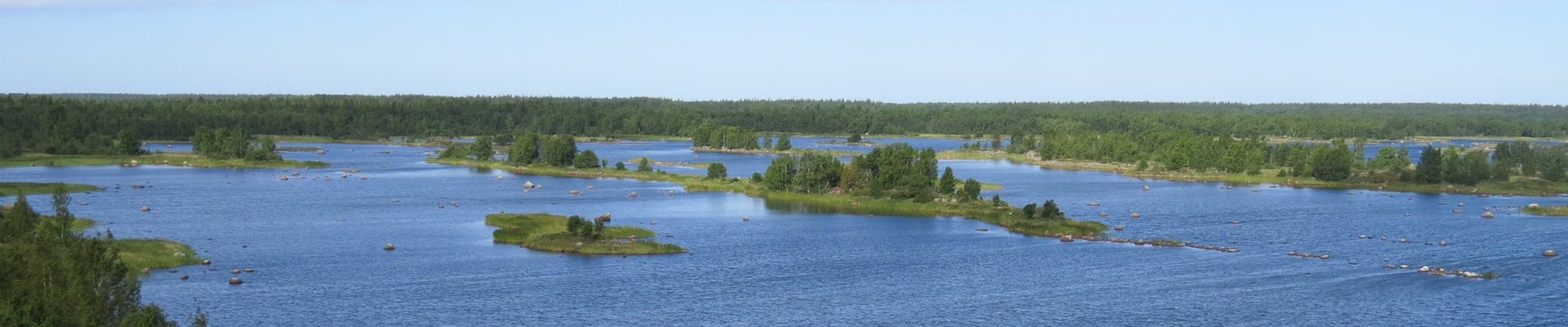
One of the highlights of this walk is right at the beginning, only 800m from the car park. Climbing the Saltkaret Observation Tower rewards one with excellent views of the many long reefs and small islands that have developed just off the coastline. You need to be at some height to be able to …
Keep reading 0 comments
I travelled down the High Coast of Sweden using the services of the #100 bus, from Ornskoldsvik, past Skuleberget, Docksta and Ullanger to Harnosand. But the highlight was going from Ornskoldsvik to Kopmanholmen by bus (#421), then cruising on the MF Ulvon to Trysunda, and to Fjaren and Ulvohamn on North Ulvon Island. The effect of the raising of the land is quite pronounced around the waterfronts of these small ports.
I cruised the Kvarken Archipelago aboard the mv Tirra and went ashore for lunch on Kuusisaari Island. This was a day long cruise from Vaasa's inner harbour costing 11 euros.
Keep reading 0 comments