Australia
Budj Bim Cultural Landscape


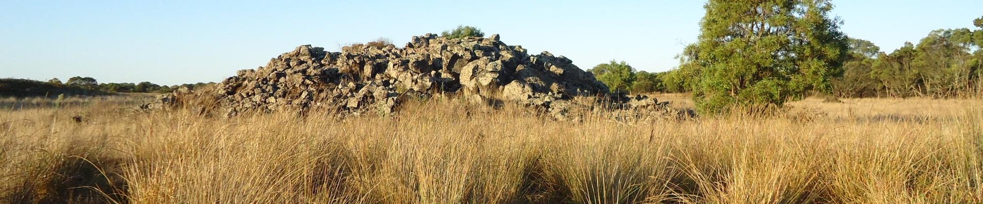
The Budj Bim Cultural Landscape covers an ancient aquaculture system developed by the Gunditjmara Aboriginal people.
They manipulated the water flow through volcanic rock and trapped fish there (especially kooyang). The associated practices are still part of the Gunditjmara living cultural tradition.
Community Perspective: The site doesn’t lie far from the Great Ocean Road from Melbourne to Adelaide. Frederik has described the Tyrendarra component (could use more guidance), while Jarek covered Budj Bim / Mt. Eccles with Lake Surprise (pretty scenery, but not much to see in terms of ancient human activity). Carlo has tips for tours.
Site Info
Official Information
- Full Name
- Budj Bim Cultural Landscape (ID: 1577)
- Country
- Australia
- Status
-
Inscribed 2019
Site history
History of Budj Bim Cultural Landscape
- 2019: Inscribed
- Inscribed
- Type
- Cultural
- Criteria
- iii
- v
Links
- UNESCO
- whc.unesco.org
- Official
-
- parks.vic.gov.au — Parks Victoria: Budj Bim National Park
All Links
UNESCO.org
- whc.unesco.org — whc.unesco.org/
Official Website
- parks.vic.gov.au — Parks Victoria: Budj Bim National Park
News Article
- May 14, 2021 abc.net.au — Feral pigs and deer killed in aerial cull to protect Budj Bim Cultural Landscape
- Jan. 19, 2020 abc.net.au — Budj Bim Cultural Landscape fire reveals new sections of ancient aquatic system
- Jan. 1, 2020 standard.net.au — Budj Bim continues to burn after lightening strike on Saturday
- Oct. 23, 2019 abc.net.au — Feral pigs put UNESCO world heritage site Budj Bim at risk of 'tremendous damage'
- Aug. 18, 2019 theage.com.au — Visitors flock to Budj Bim Indigenous site after World Heritage listing
Community Information
- Community Category
- Cultural Landscape: Associative
Travel Information
Recent Connections
-
Perfect Inscriptions
2019 -
Christian missions
Lake Condah Mission (Church of England,… -
Melina Mercouri Prize
2023: "Residing in southwestern Victori…
Connections of Budj Bim Cultural Landscape
- Trivia
-
-
Minority communities
testimony to the cultural traditions, knowledge, practices and ingenuity of the Gunditjmara (OUV) -
Customary ownership
the land is either owned by the Gunditjmara Traditional Owners and designated as Indigenous Protected Areas, or managed as the Budj Bim National Park by the State Government through Parks Victoria in cooperation with the Gunditjmara (AB ev) -
Cultural sites closely connected to volcanoes
The property also includes Budj Bim, a Gunditjmara Ancestral Being and volcano that is the source of the lava flow on which the aquaculture system is constructed. (AB ev)
-
- World Heritage Process
- Religion and Belief
-
-
Christian missions
Lake Condah Mission (Church of England, 1867)
-
- Human Activity
-
-
Aboriginal Australians
Criterion (iii): The Budj Bim Cultural Landscape bears an exceptional testimony to the cultural traditions, knowledge, practices and ingenuity of the Gunditjmara -
Aquaculture
OUV crit iii: "The extensive networks and antiquity of the constructed and modified aquaculture system.."
-
- WHS on Other Lists
-
-
Melina Mercouri Prize
2023: "Residing in southwestern Victoria within the Budj Bim heritage areas, the Gunditjmara people were recognised for their exceptional efforts in preserving and managing cultural landscapes."See neoskosmos.com
-
- Timeline
-
-
Built in the 5th millennium BC
6,600 years old
-
- WHS Names
-
-
Named after a Mountain
- "Budj Bim, also known as Mount Eccles, is a dormant volcano near Macarthur in southwestern Victoria, Australia. .......Budj Bim is the Gunditjmara name, meaning "High Head". The roughly conical peak rises 178 metres (584 ft). The peak is a scoria hill that was thrown up beside a group of three overlapping volcanic craters that now contain Lake Surprise." (Wiki)
-
News
- abc.net.au 05/14/2021
- Feral pigs and deer killed in aeri…
- abc.net.au 01/19/2020
- Budj Bim Cultural Landscape fire r…
- standard.net.au 01/01/2020
- Budj Bim continues to burn after l…
Recent Visitors
Visitors of Budj Bim Cultural Landscape
- Alexander Parsons
- Alex Goh
- BenReeve
- c82wc1
- Carlo Sarion
- CeeCeeSR
- Daniela Hohmann
- David Scott King
- Dimitar Krastev
- Emilia
- Frederik Dawson
- Hadrianus
- Henri
- Janos
- Jarek Pokrzywnicki
- Jean Lecaillon
- Jeanne OGrady
- Joel on the Road
- marcel staron
- Michael Turtle
- Mihai Dascalu
- PabloNorte
- Philipp Peterer
- phillipmeng
- Piotr Wasil
- Risson
- Roman Bruehwiler
- Schnitzel
- Shandos Cleaver
- Stijn
- Tango
- Thomas Buechler
- Wojciech Fedoruk
- Zoë Sheng
Community Reviews
Show full reviews
Budj Bim Cultural Landscape was the final UNESCO World Heritage site I visited in 2025 (visited Dec 2025). We based ourselves in Mount Gambier, about a 1.5-hour drive away from the site. The property comprises three components: Budj Bim (northern), Kurtonitj (central), and Tyrendarra (southern). While it is technically possible to visit certain publicly accessible areas in each component in a single day, I chose to slow things down and focus on one area instead—Lake Surprise within the Budj Bim component.
Budj Bim and visitor access
Budj Bim is the largest component, accounting for around 90% of the total area, and is arguably where most visitors go. Meaning “high head” in the Gunditjmara language, Budj Bim refers to the volcanic complex (Mount Eccles was its colonial name), with Lake Surprise forming its crater lake. Tae Rak (Lake Condah) and Lake Surprise are the main visitor-accessible areas within Budj Bim. The Tae Rak Aquaculture Centre in Tae Rak offers cultural tours to Budj Bim and Kurtonitj but is closed on Mondays and Tuesdays—the very days we were staying in Mount Gambier. Winda-Mara Aboriginal Corporation also offers tours to Tyrendarra, but after contacting their office they confirmed that they were understandably on a holiday break from 22 Dec until 5 Jan.
Activities around Lake Surprise
Walking, picnicking, camping, and cycling are essentially the main activities available to visitors in the area. We arrived at the campground shortly after lunch and set up for a picnic. After finishing our snacks and a bottle …
Keep reading 0 comments
I did the "lazy" thing and just parked at Lake Surprise, part of Mt Eccles National Park, which is easy as long as you have your own car. It was way back in 2018 so maybe things have changed now - for one it's actually inscribed as a UNESCO property now and the path around the lake is actually clear. Back in the days I met with the caretaker (more of a hippie that was doing this on the side) and he was a bit concerned that logs had fallen onto the path - and he made sure I would drive safely to avoid hitting 'roos - mkay. The path around the lake is usually quite easy and doesn't take too long. You can see plenty of birds this way too. From this area you can hike more inwards for the lava tunnel and "natural" bridge. Overall you are ok with half a day here and that's what I did on a drive-by. Naturally, I missed two other areas (which perhaps weren't cleared marked back in the days) but I wouldn't go back for it. I don't think this is a huge phenomenon to visit. I think what was nicer is that the entire area was empty and one is alone for a bit.
Keep reading 0 comments
Site visited in March 2018, both designated components. As Frederik described Tyrendarra area I would focus mainly on Budj Bim - Mt Eccles National Park.
To get there you will probably need your own car as there are no public transportation in the area. The best place to start the visit is a parking near Lake Surprise (coordinates - 38°03'30.8"S 141°55'21.5"E). It is also a camping area with a small visitors centre with basic information about the place. Lake Surprise is a crater lake where former volcanic activity is still visible. There are 2 hiking paths around the lake the one just near the lake (allow at least one hour for the loop) and the second that goes on the crater rim (2 hours). The area is quite spectacular although there is not much to see in terms of ancient human activity.
From that point you can also visit lava blisters and natural volcanic caves. One of them is called Natural Bridge and is located some 45 min from the visitors center. there is a direct hiking path and unsealed road. Coordinates of the place: 38°04'12.5"S 141°55'09.0"E.
If you wish to see the Tyrendarra area from Mt Eccles it is necessary to go around (via Bessiebelle to the East or using Ettrick-Condah Road to the West)
Official visitors guide with a descent map of the area:
http://parkweb.vic.gov.au/__data/assets/pdf_file/0004/315607/Mt_Eccles_NP_parknote.pdf
Keep reading 0 comments
Fortunately, UNESCO added Budj Bim in the tentative list before I finalized the whole itinerary of my Australia trip, so after checking its location, I conveniently put this unknown place as one of the must stops along the famous Great Ocean Road from Melbourne to Adelaide. Since the site was relative unknown, it was quite hard to find information and I afraid that the visit without any professional guide will not make my trip to be worthwhile, I still decided to go and explore the site by myself.
There are two components of Budj Bim, old Volcano of Mount Eccles together with nearby lake Condah and the old lave flow near town of Tyrendarra. After checking with google map, I decided to visit only the Tyrendarra area as the geography of shallow lake Condah and swampy Tyrendarra both are quite similar, and I have no interest to climb Mount Eccles or old mission ruins. On the road, I put my navigator to Tyrendarra Indigenous Protected Area, while the road is good just next to the main highway, the place gave a feeling that it was located on the middle of nowhere. I parked my car and saw a sign of warning of flood and snakes! Since I visited on spring, the small creek flooded the whole area of old lava flow. The small pedestal bridge to the nominated area was almost submerged by the strong high water. After I crossed the bridge I found an explanation board of the …
Keep reading 0 comments