Mauritania
Banc d'Arguin


Banc d'Arguin National Park is renowned for its many nesting and migrating birds.
The park covers a rich marine and coastal ecosystem between the Sahara and the Atlantic Ocean. Its mudflats and sandbanks provide resting places for over two million migrant shorebirds from northern Europe, Siberia, and Greenland. Due to the permanent upwelling off Cap Blanc, the surrounding waters are some of the richest fishing waters in western Africa.
Community Perspective: it’s a huge park, but the general bird-viewing conditions seem disappointing. Solivagant describes his visit in March 2007, which included a 4x4 seashore drive and a boat ride. Els visited in late 2024 and especially enjoyed the offshore sandbanks that look like floating icebergs.
Site Info
Official Information
- Full Name
- Banc d'Arguin National Park (ID: 506)
- Country
- Mauritania
- Status
-
Inscribed 1989
Site history
History of Banc d'Arguin
- 1989: Inscribed
- Inscribed
- Type
- Natural
- Criteria
- ix
- x
Links
- UNESCO
- whc.unesco.org
- Official
-
- pnba.mr — Le Parc National
All Links
UNESCO.org
- whc.unesco.org — whc.unesco.org/
Official Website
- pnba.mr — Le Parc National
Community Information
- Community Category
- Wildlife habitat: Fauna
Travel Information
Recent Connections
-
Oceanic Dolphins
“The bottlenose dolphin and the Atlanti…
-
Perfect Inscriptions
1989 -
Théodore Monod
Monod was one of the founders and major…
Connections of Banc d'Arguin
- Individual People
-
-
Théodore Monod
Monod was one of the founders and major promoters of this park. He conducted research there since the 1920s and 1930s, studying: Marine and coastal fauna (especially migratory birds), seagrass beds and coastal ecosystems, and the Imraguen communities, a fishing people living in harmony with the environment. He contributed to the recognition of the site's ecological and scientific importance, well before its inscription on the UNESCO list. The Banc d'Arguin embodies his vision of a respectful and sustainable coexistence between man and nature. -
Prince Henry the Navigator
Sponsored a trip to "the Bay of Arguin in 1443 and built an important "forte-feitoria" (a fort protecting a trading post) on the island of Arguin around the year 1448."See en.wikipedia.org
-
- Geography
-
-
Antipodes points
BANC D ARGUIN NATIONAL PARK=LAGOONS OF NEW CALEDONIA(atolls d'entrecasteaux) N20 14 4.992 W16 6 32.004 = S18 26 12 E163 4 49 -
Sahel
"The biogeographical province of the Western Sahel in which Banc d • Arguin is located" (AB ev) -
Cape
Cape Tafarit -
Atlantic Ocean
Part of the East Atlantic migratory flyway and faces the Atlantic. It was also part of the Atlantic trade route down the African coast
-
- Trivia
-
-
Built or owned by Dutch
Arguin Island (part of the WHS) was captured from Portugal by the Dutch 1633-78 (apart from a brief recapture by England in 1665). And then again -this time taken from the French in 1722-4 -
Built or owned by Germans
Arguin was owned by Brandenburg/Prussia from 1685-1721. They built a fort there. -
Built or owned by Portuguese
The island of Arguin was controlled by Portugal from 1445 - 1633. -
Slow Food Movement
Mullet Bottarga (roe)
-
- History
-
-
WIC
Arguin was conquered by the WIC in 1633, using it for the trade in natural gum -
Castaways or shipwrecked mariners
French frigate Méduse (1810) struck the Bank of Arguin off the coast of present-day Mauritania and became a total loss. .. Survivors resorted to suicide or killing each other, or "landed immediately on the coast of Africa, with most of the survivors making their way overland to Senegal, though some died on the way". After 13 days at sea, the raft was discovered with only 15 people still alive.See en.wikipedia.org
-
Shell Mounds (Middens)
-
Neolithic age
Neolithic archaeological sites and vestiges of the Almoravid civilization are found on some of the islands. (EOEarth)
-
- Ecology
-
-
Turtles and tortoises
Habitat of green, hawksbill, loggerhead, leatherback and olive ridley turtles
-
Mangroves
The mangrove swamp in the park is a relict of a previous humid geological period when Banc d'Arguin was a vast estuary mouth for rivers flowing from the Sahara. (unesco website) -
Dunes
Coastal dunes -
Ratites
common ostrich -
Seals
monk seal -
Seagrass beds
the vast expanse of marshes covered with seagrass beds (crit ix) -
Flamingos
"Wintering shorebirds ... include tens of thousands of flamingo (Phoencopterus rubber)" (AB ev) -
Strict Nature Reserve
Partly: Cap Blanc Integral Reserve. Visitor restrictions unknown. -
Pelicans
"Notable breeding birds include white pelican Pelecanus onocrotalus" (AB ev) -
Mudflats
"coastal areas covered with marshes and mudflats" (AB ev) -
Oceanic Dolphins
“The bottlenose dolphin and the Atlantic hump-backed dolphin are frequently sighted in the property.” (OUV)
-
Bird Migrations
Eastern Atlantic Migratory Flyway, Birds -
Swamps and Marshes
"this Park is formed of sand dunes, areas of coastal swamps, small islands and shallow coastal waters" (OUV)
-
- World Heritage Process
-
-
Perfect Inscriptions
1989 -
First inscriptions
Mauritania 1989
-
- Human Activity
-
-
Boats
French frigate Méduse (1810) struck the Bank of Arguin and became a total lossSee en.wikipedia.org
-
Natural sites with indigenous human population
1000 or so Imraguen people live in the park, subsisting by fishing. -
Traditional Hunting
fishing techniques involving collaboration with wild dolphines practiced by the Amrig
-
- WHS on Other Lists
-
-
Ramsar Wetlands
Banc d'Arguin, 1982
-
- Timeline
-
-
Holocene
Formed first by a "marine transgresion" from sea rise following the last ice age which "invaded" the shore line and was then followed by an ongoing process of tidal and wind sand deposition. SeeSee www.academia.edu
-
News
No news.
Community Reviews
Show full reviews
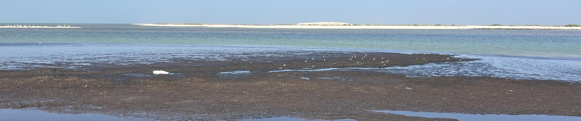
Mauritania’s Banc d’Arguin NP is rarely visited and has only been reviewed once, about 18 years ago. However, this is the number one place for waterfowl and migratory waders among the several "bird WHS" along the West African Coast. It is “better” than Djoudj and the Saloum Delta, and only the 2025 nomination of the Bijagos Archipelago in Guinea-Bissau comes close, but it still has only 50% of its numbers. We spent a full day and a night in its core zone, stretching 170km along the Atlantic Coast.
The Banc d’Arguin is so rich because it lies next to an ocean upwelling that produces nutrient-rich cooler waters. This sets a whole food chain of phytoplankton-filter feeders-fish-birds-marine mammals in motion.
We approached it from the South, driving for 2.5 hours from the capital Nouakchott. This is mostly a good paved road, where our drivers even clocked 130km/h. The surrounding landscape is rather featureless, though you will see some dromedaries roaming around. We made a first stop at Mamghar, one of the seven fishing villages inside the park. The smell of fish is predominant here: the people leave their gutted fish drying out on the fences surrounding the corrals for the goats.
On the outskirts of town, you can walk onto the seabank and observe bird colonies that have found their nesting or resting spot right there. We saw two sandbanks right offshore, fully covered by a variety of bird species, including larger ones such as pelicans. A bit more inland, there …
Keep reading 2 comments
The global significance of Banc d’Arguin is incontrovertible – “Of the estimated seven million wading birds which use the Atlantic flyway, approximately 30% spends the winter at Banc d'Arguin, which hosts the largest concentration of wintering waders and one of the most diversified communities of nesting piscivorous birds in the world.” However, like most “wetland” WHS, it is primarily a destination for ornithologists who can give it the right amount of time and expertise at the optimum season of the year.
The Park is huge and stretches along c30% of Mauritania’s coast. Its designated area is about 50% maritime and 50% land and a 4x4 vehicle is essential for the latter. The nearest asphalt is at the Chami entrance at approximately the mid point N-S. From there it is 30kms across sandy and often unclear tracks to the fishing village of Iwik which is the main place for hiring the boat necessary to reach the “banks” themselves where the main birding areas are. Any attempt to go north or south from Iwik can take you on tracks leading into dunes or areas inundated at high tides and having treacherous crusted surfaces. Our local driver drove these to the southern exit at Mamghar in order for us to see the Cape Timrit area. From there we had hoped to take the “classic” c170 kms “low tide” sea shore drive to Nouakchott but the tide times were not convenient and we had to “force” a route east out of …
Keep reading 0 comments