Niger
Air and Téneré

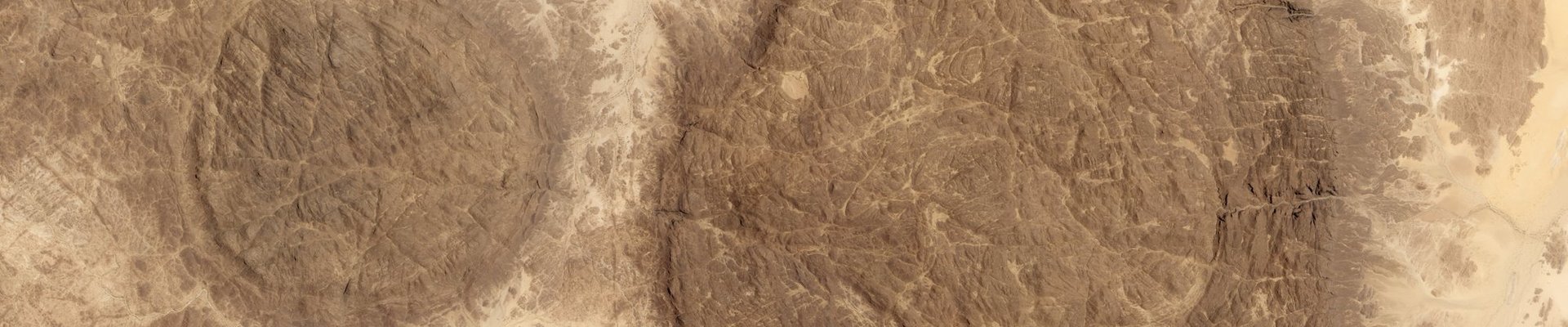
The Air and Ténéré Natural Reserves comprises a large protected area that includes the Saharan desert of Ténéré and the volcanic massif of the Aïr Mountains, a Sahelian ‘island’ within the desert.
The landscape with its blue marble mountains and sand dunes is of outstanding beauty. Due to its isolation, numerous Saharo-Sahelion wildlife species that are rare elsewhere have managed to survive in the Aïr. One-sixth of the reserve is a sanctuary for Addax, a critically endangered species of antelope.
Community Perspective: This site is rarely visited due to the safety situation and remote location.
Site Info
Official Information
- Full Name
- Air and Téneré Natural Reserves (ID: 573)
- Country
- Niger
- Status
-
Inscribed 1991
Site history
History of Air and Téneré
- 1992: In Danger
- region in which this site is situated has been affected by civil disturbance
- 1991: Inscribed
- Inscribed
- In Danger
- region in which this site is situated has been affected by civil disturbance Since 1992
- Type
- Natural
- Criteria
- vii
- ix
- x
Links
- UNESCO
- whc.unesco.org
- Related
-
- africanworldheritagesites.org — African World Heritage Sites
All Links
UNESCO.org
- whc.unesco.org — whc.unesco.org/
Related Resources
- africanworldheritagesites.org — African World Heritage Sites
Community Information
- Community Category
- Natural landscape: Desert
Travel Information
Red Zone Travel Advisory
Niger fully off-limits
One thousand visitors or fewer
Recent Connections
-
Perfect Inscriptions
1991 -
Red Zone Travel Advisory
Niger fully off-limits
-
Location for a classic documentary
Tenere (2020)See www.imdb.com
Connections of Air and Téneré
- Individual People
-
-
Ibn Battuta
Possible: "We first came to the country of Air, a land rich in pasture. People buy sheep from the Berbers there and cut their meat into strips, which they dry. "
-
- Geography
-
-
Sahel
The Aïr constitutes a Sahelian enclave surrounded by a Saharian desert (AB ev) -
Territorial Highest points
Mont Idoukal-n-Taghès (2,022m): the highest mountain in Niger -
Sahara
"The Aïr constitutes a Sahelian enclave surrounded by a Saharian desert" (OUV)
-
- Trivia
- History
-
-
Songhai Empire
Became the furthest northern outpost of the Songhai Empire in the early 16th century - until recaptured by the Tuareg later in the century -
Neolithic age
Palaeolithic and Neolithic archaeological sites are found at many locations in the reserve, as are rock engraving sites. (unesco website)
-
- Ecology
-
-
Strict Nature Reserve
Partly: Sanctuaire des Addax (visitor access unknown) -
Critically endangered fauna species
Dama gazelle (100-200 extant individuals worldwide), Northwest African cheetah -
Bird Migrations
The massif of the Aïr also constitutes a transit zone for a large number of afrotropical and palaearctic migratory birds. (unesco website) -
Dunes
The "live dunes" of the Ténéré are an example of erosion under way the landscape is rapidly modified on a geological time scale by the displacement and deposition of sand (AB ev) -
Ratites
common ostrich -
Ergs
"The "live dunes" of the Téneré are an example of erosion under way the landscape is rapidly modified on a geological time scale by the displacement and deposition of sand" (IUCN eval). There is no Nom File but the actual word is applied on the Site's UNESCO page with a photo of "A dune sea (Erg) between Fachi and Bilma." -
Hyper-arid
Ténéré (desert environment OUV): "The climate is hyper-arid, extremely hot, sunny and dry year-round and there is virtually no plant life." (wiki) -
Yardangs
-
Multiple biogeographic realms
At the junction of Palaearctic and Afrotropical realms
-
- Damaged
-
-
Poaching
The most noticeable problem is poaching of gazelles and ostriches within the reserve by military personnel (AB ev) / Poaching continues to strongly affect the site due to insufficient or lack of control linked to the large area of the property. Illegal hunting has decimated African ostrich populations in Africa North, addax and dama gazelle during the last years but it now threatens other mammals. Dorcas gazelles, Barbary sheep and Nubian and Arabian bustards are the species currently affected by poaching. (IUCN)
-
- World Heritage Process
-
-
Slow Starters
1974-1991 : 17 years -
Perfect Inscriptions
1991 -
First inscriptions
Niger 1991
-
- Human Activity
-
-
Natural sites with indigenous human population
The 3,500-7,000 Twareg inhabitants for the most part maintain a lifestyle of transhumant pastoralism, raising goats and camels (unesco website) -
Petroglyphs
-
- WHS on Other Lists
-
-
Ramsar Wetlands
Gueltas et Oasis de l’Aïr -
World Monuments Watch (past)
Giraffe Rock Art Site, Agadez (2000) -
World Biosphere Reserves
Air et Ténéré (1997) -
IUCN Conservation Outlook Assessment Critical
-
- Timeline
-
-
Proterozoic
La zone du socle précambrien de l'Aïr est composée de dépôts de roches sédimentaires plissées et métamorphisées (gneiss, schistes) et de roches volcaniques datant du Protérozoïque inférieur. (wiki fr)
-
- Visiting conditions
-
-
Red Zone Travel Advisory
Niger fully off-limits
-
One thousand visitors or fewer
DD :“Il n'y a pas eu de tourisme dans la zone en raison des problčmes d'insécurité jusqu'en 2013. Par la suite, il y a eu quelques petites excursions organisées par des opérateurs locaux, mais pas de maničre officielle”
-
- WHS Names
-
-
Named after a Mountain
"The Aïr Mountains or Aïr Massif (Tamashek: Ayăr; Hausa: Eastern Azbin, Western Abzin) is a triangular massif, located in northern Niger, within the Sahara. Part of the West Saharan montane xeric woodlands ecoregion, they rise to more than 1,800 m (5,900 ft) and extend over 84,000 km2 (32,000 sq mi)" (Wiki)
-
- Literature & Film
-
-
Location for a classic documentary
Tenere (2020)See www.imdb.com
-
News
No news.
Recent Visitors
Community Reviews
Show full reviews
Amazing isolated rock formations filled with send. And no tourists as all depends on Tuareg activities in the region.
Keep reading 0 comments