Denmark
Aasivissuit - Nipisat

Aasivissuit-Nipisat, Inuit Hunting Ground between Ice and Sea, is a cultural landscape shaped by the seasonal migration of the Inuit.
This Arctic landscape holds key locations along routes that were used from coast to inland in summer and then back again in late autumn. They are archaeological sites and settlements that are still in use. This landscape was settled about 4,200 years ago, with (Palaeo-)Inuit sustaining themselves by marine and terrestrial hunting.
Community Perspective: to put your feet in the area, it only needs participation in a trip to the glacier from Kangerlussuaq – “you drive past/through them but you don't really see anything spectacular” as Zoë sums it up. Michael explored the area on his bike and managed to find a WHS information plaque. Thomas managed to get to the "hidden" archaeological places with a local guide.
Site Info
Official Information
- Full Name
- Aasivissuit – Nipisat. Inuit Hunting Ground between Ice (ID: 1557)
- Country
- Denmark
- Status
-
Inscribed 2018
Site history
History of Aasivissuit - Nipisat
- 2018: Inscribed
- Inscribed
- Type
- Cultural
- Criteria
- v
Links
- UNESCO
- whc.unesco.org
- Official
-
- inuithunting.gl — Inuit hunting
All Links
UNESCO.org
- whc.unesco.org — whc.unesco.org/
Official Website
- inuithunting.gl — Inuit hunting
News Article
- Oct. 27, 2021 wallpaper.com — Greenland’s Qaammat Pavilion for Unesco celebrates land and people
Community Information
- Community Category
- Cultural Landscape: Continuing
Travel Information
Recent Connections
-
Untranslated Toponyms
Aasivissuit means 'summer camps' in Inu… -
Built in the 3rd Millennium BC
from 2150 BC to present day -
Located in a TCC Territory
Greenland
Connections of Aasivissuit - Nipisat
- Geography
-
-
Dependent territories
Part of Greenland, an autonomous territory within the Kingdom of Denmark. -
Arctic
-
Arctic Ocean
-
Glaciers
Isunnguata Sermia -
Linear inscriptions
-
Fjords
Partly located in fjord areas -
Full White Nights
-
- Trivia
-
-
Largest cultural WHS
417,800 ha (#4) -
Cultural sites taking up an entire island
Nipisat Island -
Minority communities
rich archaeological record of Palaeo-Inuit and Inuit cultures (OUV) -
Tourist Treks
Arctic Circle Trail : Kangerlussuaq / Sisimiut (Duration: 7 days or more)See aac.gl
-
- World Heritage Process
-
-
Inscribed on a single criterion only
crit v only -
Perfect Inscriptions
2018
-
- Human Activity
-
-
Hunter-gatherers
"Fisher-hunter-gatherer cultures have created an organically evolved and continuing cultural landscape" (official description) -
Traditional Hunting
-
- Constructions
- WHS on Other Lists
-
-
Located in a TCC Territory
Greenland
-
- Timeline
-
-
Built in the 3rd Millennium BC
from 2150 BC to present day
-
- WHS Names
-
-
Untranslated Toponyms
Aasivissuit means 'summer camps' in Inuit.
-
News
- wallpaper.com 10/27/2021
- Greenland’s Qaammat Pavilion for U…
Community Reviews
Show full reviews
Well before our visit, I made contacts with the UNESCO liaison office for Aasivissuit-Nipisat-it is a small group of 3 dedicated officers based in Sisimiut and Kangerlussuaq. One of them is the park ranger, Christian who patrols the area every day and calls it his office, exactly 585,000 football fields large! We rented a car (an adventure on itself to find it, price around 100 Euros) and Christian volunteered as driver and probably the best guide you could find, as he knows some hidden archaeological places along the road to the ice cap and Point 660. Like remains of hunting grounds, and places where the rendeer meat was dried before transport to the camps. As he works full time, he is normally available late afternoon. He can be contacted under chpj@qeqqata@gland one has to agree with him time and fees, but it is more economical than the organized tour, and the emphasis is the Inuit Hunting grounds, not the ice bergs. As we traveled privately, we could stop at any photo opportunity along the way which there are plenty. The landscape is amazing. Christian also has a fleet of 10 electric fatbikes which are offroad bicycles with oversized tyres, perfect for the long gravel roads and a sustainable way to discover the beauty of Greenland. In October 2024, the new road from Kangerlussuaq to Sisimiut should be opened, providing yet another opportunity to discover the UNESCO core zone in the opposite direction to the sea shore. You could bring your …
Keep reading 0 comments
Visit in July 2019
I have only a small amount to add to the two previous reviews.
If you should happen to have your own bicycle in Kangerlussuaq, it is possible to ride through the core zone of the Aasivissuit-Nipisat WHS along the way to the western edge of the Greenland Ice Sheet. In total, the road runs for 35.5 km from the airport in Kangerlussuaq up to the edge of the ice, rising from sea level to 520 meters a.m.s.l. along the way. It is Greenland’s longest road, and, some may say, Greenland’s only road, which is, more or less, correct. The road is gravel, and at the start is in a reasonably good condition, but, in a typical manner, as you progress towards the east the condition deteriorates more and more, with several short, steep sections having a rather loose surface near the end. At around the 23 km mark, there is a locked gate which you can walk or ride around. The sign there, which is one of the few around that is only in Greenlandic and Danish, mentions something about motorized vehicles, so they are probably prohibited beyond that point. However, I encountered two tour buses, two researcher’s trucks, and two unidentified vans after the gate, so presumably official and tourism vehicles are allowed.
One kilometer beyond that gate, you enter the core zone of the WHS. There is a small information plaque on a stand about 20 meters off the road, which …
Keep reading 0 comments
Landscapes are always a bit tricky to see or understand. Hunting grounds of the Inuits even more. There is little infrastructure to get into these places. The base to explore is Kangerlussuaq, 1h away from Ilulissat or Nuuk either way. The town is small but hotels are plentiful. (I stayed at the Old Camp mainly because the Polar Lodge was already full but it is also that much cheaper, although then you are 2km away from town and need to take an hourly bus to move around. The tours still pick you up here though.)
You can only organize tours via the same agency and the programs are set by date and time slots. I was told one could potentially customize a tour but that ended up not being done. I took two tours: the ice wall and the sightseeing tour. The sightseeing tour will explore the hunting area and other parts like the harbor, the shut US research station (apparently ordered to be moved by the Trump administration), the town and Husky puppies (sho qwute!!).
The main reason this was worth is because of the Inuit guide Kimmi. She is Greenland's unknown superstar and I shall not go into details of what her personal life holds. All I can tell is that she's a really good guide and a hunter. I don't mean this in a advertisement but having her as guide means she will try to understand what you want to know about the area and …
Keep reading 0 comments
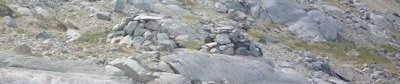
During my trip to Greenland in 2012 I spent two days in Kangerlussuaq, Greenland’s biggest airport and usual entry point for most tourists. There is little to do in this small village (though there is small museum), although you can hike around or take a trip to continental glacier, located around 40 km from Kangerlussuaq (the road to the glacier is actually the longest in Greenland). Based on the map from the nomination file, the road crosses the core WHS area of Aasivissuit-Nipisat. Although the highlight of the trip is the glacier itself, the road is also interesting, with picturesque landscapes of small lakes, meadows (really green in the middle of July) and various stone forms. I remember our guide told us a lot about Innuits, their hunting habits and everyday life. On the road there were at least two Innuit tombs (see photo), dated 400 years back (I suspect they are marked on the official map as “place of worship”). Innuits buried their dead in sitting position and the body was then belayed by stones. On top there was always a flat stone, which also helped to differentiate burial mounds from orientation points. Such a construction of the tomb protected the buried body from wild animals.
I remembered this area as a nice natural landscape, perhaps other places in the core zone provide more artifacts of Innuit culture and justify inscription as cultural, not mixed site.
Keep reading 0 comments